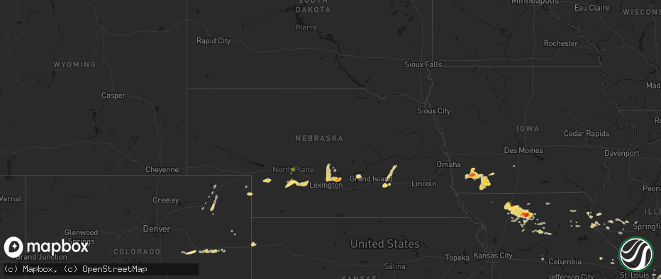
Hail Map in Nebraska on May 16, 2026
The weather event in Nebraska on May 16, 2026 includes Hail, Wind, and Tornado maps. 11 states and 896 cities were impacted and suffered possible damage. The total estimated number of properties impacted is 68,678.
Hail
Wind
Tornado
68,678
Estimated number of impacted properties by a 1.00" hail or larger29,383
Estimated number of impacted properties by a 1.75" hail or larger1,595
Estimated number of impacted properties by a 2.50" hail or largerStorm reports in Nebraska
Nebraska
| Date | Description |
|---|---|
| 05/16/20266:58 PM CDT | A local report indicates 1.00 inch wind near 6 W Lexington |
| 05/16/20266:58 PM CDT | A local report indicates 1.00 inch wind near 6 N Riverdale |
| 05/16/20266:56 PM CDT | A local report indicates 60 MPH wind near 1 N Kearney |
| 05/16/20266:52 PM CDT | Large cottonwood limbs down. Estimated 60 to 70 mph wind. |
| 05/16/20266:48 PM CDT | A local report indicates 60 MPH wind near 1 N Kearney |
| 05/16/20266:47 PM CDT | A local report indicates 65 MPH wind near 1 W Kearney |
| 05/16/20266:34 PM CDT | Public report via social media of 2 inch hail. |
| 05/16/20266:26 PM CDT | Social media report of quarter to half dollar sized hail. |
| 05/16/20266:22 PM CDT | Majority of hail was 3/4 inch in size with a few 1 inch sized stones. |
| 05/16/20266:14 PM CDT | Biggest hail was 3 inches. It broke windows. It hailed for at least 30 minutes beginning around 5:45 pm. |
| 05/16/20265:57 PM CDT | A local report indicates 1.75 inch wind near Boelus |
| 05/16/20265:45 PM CDT | A local report indicates 1.50 inch wind near 2 E Henderson |
| 05/16/20265:42 PM CDT | A local report indicates 1.75 inch wind near Henderson |
| 05/16/20265:28 PM CDT | A local report indicates 1.75 inch wind near 1 E Miller |
| 05/16/20265:26 PM CDT | A local report indicates 2.00 inch wind near 6 W Osceola |
| 05/16/20265:20 PM CDT | A local report indicates 1.00 inch wind near 7 WNW Stromsburg |
| 05/16/20265:20 PM CDT | A local report indicates 1.00 inch wind near 2 E Oconto |
| 05/16/20264:52 PM CDT | Actually 1 inch 5/8 inches in diameter. |
| 05/16/20264:52 PM CDT | A local report indicates 1.00 inch wind near North Platte |
| 05/16/20264:50 PM CDT | Hail slightly smaller than golf ball. |
| 05/16/20264:39 PM CDT | A local report indicates 1.00 inch wind near 7 NW Wellfleet |
| 05/16/20264:21 PM CDT | A local report indicates 1.75 inch wind near 5 NW Wellfleet |
| 05/16/202611:52 AM CDT | House lost roof west of crystal springs. |
| 05/16/20261:32 AM CDT | A local report indicates 61 MPH wind near Falls City |
| 05/16/202612:43 AM CDT | A local report indicates 62 MPH wind near Barneston |
| 05/15/202611:54 PM CDT | A local report indicates 88 MPH wind near 2 SW Fairbury |
| 05/15/202611:53 PM CDT | Power is out in fairbury... Trees down... And visibility is 0. |
| 05/15/202611:53 PM CDT | A local report indicates 88 MPH wind near 7 WNW Fairbury |
| 05/15/202611:52 PM CDT | A local report indicates 76 MPH wind near 1 SSE Fairbury |
| 05/15/202611:46 PM CDT | A local report indicates 66 MPH wind near 7 WNW Fairbury |
| 05/15/202611:44 PM CDT | A local report indicates 59 MPH wind near 5 WSW Endicott |
| 05/15/202611:30 PM CDT | A local report indicates 68 MPH wind near 3 E Davenport |
| 05/15/202611:24 PM CDT | A local report indicates 61 MPH wind near 2 SW Carleton |
| 05/15/202611:24 PM CDT | Tree damage in hebron. Time estimated from radar. |
| 05/15/202611:22 PM CDT | A local report indicates 61 MPH wind near 4 ESE Davenport |
| 05/15/202611:22 PM CDT | A local report indicates 68 MPH wind near 3 ENE Davenport |
| 05/15/202611:20 PM CDT | A local report indicates 75 MPH wind near 3 N Chester |
| 05/15/202611:19 PM CDT | Personal weather station. |
| 05/15/202611:18 PM CDT | A local report indicates 71 MPH wind near 3 SW Carleton |
| 05/15/202611:14 PM CDT | A local report indicates 66 MPH wind near 5 NNE Western |
| 05/15/202611:13 PM CDT | A local report indicates 67 MPH wind near 3 WNW Davenport |
| 05/15/202611:13 PM CDT | A local report indicates 65 MPH wind near 3 SW Davenport |
| 05/15/202611:12 PM CDT | A local report indicates 72 MPH wind near 3 ESE Ruskin |
| 05/15/202611:11 PM CDT | A local report indicates 73 MPH wind near 5 NNE Western |
| 05/15/202611:10 PM CDT | Off-duty nws employee reported 7 overturned center pivots between hebron and ruskin. Time estimated from radar. |
| 05/15/202611:10 PM CDT | A local report indicates 68 MPH wind near 5 W Davenport |
| 05/15/202611:06 PM CDT | A local report indicates 72 MPH wind near 1 SSW Oak |
| 05/15/202611:01 PM CDT | Several large trees down in town. |
| 05/15/202611:01 PM CDT | A local report indicates 58 MPH wind near 4 W Oak |
| 05/15/202611:00 PM CDT | Snapped tree branches across the roadway. |
| 05/15/202610:58 PM CDT | Several large trees down in town. |
| 05/15/202610:48 PM CDT | A local report indicates 60 MPH wind near Wood River |
| 05/15/202610:47 PM CDT | A local report indicates 58 MPH wind near 3 SW Davenport |
| 05/15/202610:46 PM CDT | Personal weather station. |
| 05/15/202610:45 PM CDT | A local report indicates 60 MPH wind near 6 NW Nelson |
| 05/15/202610:39 PM CDT | A local report indicates 60 MPH wind near 2 S Milligan |
| 05/15/202610:37 PM CDT | A local report indicates 64 MPH wind near 1 SSE Davenport |
| 05/15/202610:35 PM CDT | A local report indicates 64 MPH wind near 2 SSE Davenport |
| 05/15/202610:31 PM CDT | A local report indicates 63 MPH wind near Kearney Airport |
| 05/15/202610:31 PM CDT | A local report indicates 60 MPH wind near 6 ENE Kearney |
| 05/15/202610:30 PM CDT | A local report indicates 60 MPH wind near 1 W Heartwell |
| 05/15/202610:27 PM CDT | A local report indicates 58 MPH wind near 6 N Exeter |
| 05/15/202610:27 PM CDT | A local report indicates 60 MPH wind near 1 W Heartwell |
| 05/15/202610:25 PM CDT | Personal weather station. |
| 05/15/202610:24 PM CDT | A local report indicates 60 MPH wind near 4 NNW Ohiowa |
| 05/15/202610:24 PM CDT | A local report indicates 65 MPH wind near 1 S Ayr |
| 05/15/202610:24 PM CDT | A local report indicates 71 MPH wind near 8 ESE Kearney |
| 05/15/202610:19 PM CDT | A local report indicates 67 MPH wind near 1 N Minden |
| 05/15/202610:17 PM CDT | Multiple reports of significant wind damage in and around minden. Time estimated from radar and nearby observations. |
| 05/15/202610:17 PM CDT | Personal weather station. |
| 05/15/202610:16 PM CDT | A local report indicates 75 MPH wind near 4 SSE Fairmont |
| 05/15/202610:15 PM CDT | A local report indicates 69 MPH wind near 3 ENE Geneva |
| 05/15/202610:15 PM CDT | A local report indicates 58 MPH wind near 1 SSE Minden |
| 05/15/202610:13 PM CDT | Personal weather station. |
| 05/15/202610:11 PM CDT | A local report indicates 61 MPH wind near 2 WNW Cowles |
| 05/15/202610:10 PM CDT | A local report indicates 63 MPH wind near 2 NNW Holstein |
| 05/15/202610:09 PM CDT | A local report indicates 59 MPH wind near 2 ESE Axtell |
| 05/15/202610:08 PM CDT | A local report indicates 69 MPH wind near 3 ENE Geneva |
| 05/15/202610:06 PM CDT | A local report indicates 58 MPH wind near 3 WNW Hildreth |
| 05/15/202610:05 PM CDT | A local report indicates 63 MPH wind near 3 WSW Fairmont |
| 05/15/202610:04 PM CDT | A local report indicates 59 MPH wind near 5 WNW Riverton |
| 05/15/202610:04 PM CDT | A local report indicates 59 MPH wind near 3 WNW Riverton |
| 05/15/202610:03 PM CDT | A local report indicates 63 MPH wind near 1 SW Axtell |
| 05/15/202610:02 PM CDT | A local report indicates 62 MPH wind near 5 W Geneva |
| 05/15/202610:01 PM CDT | A local report indicates 82 MPH wind near 2 ENE Holdrege |
| 05/15/202610:00 PM CDT | A local report indicates 61 MPH wind near 1 W Hildreth |
| 05/15/202610:00 PM CDT | A local report indicates 73 MPH wind near 2 SSE Grafton |
| 05/15/202610:00 PM CDT | A local report indicates 63 MPH wind near 3 WSW Fairmont |
| 05/15/202610:00 PM CDT | A local report indicates 1.00 inch wind near Deweese |
| 05/15/20269:58 PM CDT | A local report indicates 61 MPH wind near 3 NW Fairmont |
| 05/15/20269:57 PM CDT | A local report indicates 59 MPH wind near 3 N Wilcox |
| 05/15/20269:56 PM CDT | A local report indicates 74 MPH wind near 2 NNW Wilcox |
| 05/15/20269:56 PM CDT | A local report indicates 72 MPH wind near 2 ESE Fairmont |
| 05/15/20269:56 PM CDT | A local report indicates 72 MPH wind near 1.5 ESE Fairmont |
| 05/15/20269:56 PM CDT | A local report indicates 59 MPH wind near 5 SSE Wilcox |
| 05/15/20269:54 PM CDT | A local report indicates 62 MPH wind near 2 NNW Geneva |
| 05/15/20269:52 PM CDT | A local report indicates 73 MPH wind near 2 SSE Grafton |
| 05/15/20269:47 PM CDT | Report from mping: golf ball |
| 05/15/20269:46 PM CDT | A local report indicates 62 MPH wind near 3 WSW Grafton |
| 05/15/20269:46 PM CDT | A local report indicates 62 MPH wind near 4 S Grafton |
| 05/15/20269:45 PM CDT | A local report indicates 58 MPH wind near 1 SSE Harlan County Dam |
| 05/15/20269:39 PM CDT | A local report indicates 60 MPH wind near 3.5 WSW Grafton |
| 05/15/20269:35 PM CDT | A large tree has fallen on a residence in aurora. |
| 05/15/20269:34 PM CDT | A local report indicates 65 MPH wind near 2 SW Henderson |
| 05/15/20269:34 PM CDT | A local report indicates 65 MPH wind near 1 SW Henderson |
| 05/15/20269:33 PM CDT | A local report indicates 69 MPH wind near 2 N Woodruff |
| 05/15/20269:21 PM CDT | Gust occurred at the aurora awos. |
| 05/15/20269:17 PM CDT | A narrow tornado reported. The tornado has since lifted. |
| 05/15/20269:07 PM CDT | A local report indicates 66 MPH wind near 1 SSE Central City |
| 05/15/20268:58 PM CDT | A local report indicates 1.25 inch wind near Malcolm |
| 05/15/20268:56 PM CDT | Public report of golf balls. |
| 05/15/20268:55 PM CDT | A local report indicates 2.75 inch wind near 4 W Plymouth |
| 05/15/20268:55 PM CDT | Report received via nwschat from em. |
| 05/15/20268:54 PM CDT | A local report indicates 1.00 inch wind near Malcolm |
| 05/15/20268:52 PM CDT | Image sent in. |
| 05/15/20268:51 PM CDT | Nws employee. |
| 05/15/20268:50 PM CDT | A large branch came down and damaged a gutter and a roof in nw grand island. |
| 05/15/20268:50 PM CDT | A local report indicates 1.50 inch wind near Grand Island |
| 05/15/20268:49 PM CDT | Spotter report. |
| 05/15/20268:37 PM CDT | Several reports of golfball sized hail. |
| 05/15/20268:36 PM CDT | A local report indicates 1.00 inch wind near Pleasant Dale |
| 05/15/20268:35 PM CDT | Public report of half dollar sized hail. |
| 05/15/20268:35 PM CDT | Gust occurred at the holdrege airport. |
| 05/15/20268:30 PM CDT | Report from mping: golf ball |
| 05/15/20268:27 PM CDT | Report from mping: hen egg+ |
| 05/15/20268:15 PM CDT | Lots of hail on the ground. Measured hail of approx. 2 inches. |
| 05/15/20268:12 PM CDT | Most hail was dime to penny size but a few were larger than quarters. |
| 05/15/20268:11 PM CDT | A local report indicates 1.50 inch wind near 1 E Crete |
| 05/15/20268:03 PM CDT | A local report indicates 2.50 inch wind near De Witt |
| 05/15/20268:00 PM CDT | A local report indicates 2.00 inch wind near Shelton |
| 05/15/20267:57 PM CDT | Report of some quarter size hail mixed with nickels and peas. |
| 05/15/20267:50 PM CDT | A local report indicates 1.00 inch wind near Wilber |
| 05/15/20267:49 PM CDT | A local report indicates 1.50 inch wind near Shelton |
| 05/15/20267:43 PM CDT | A local report indicates 1.75 inch wind near Lexington |
| 05/15/20267:41 PM CDT | A local report indicates 1.00 inch wind near 5 W Lexington |
| 05/15/20267:26 PM CDT | Quarter to half dollar size wind driven hail. |
| 05/15/20267:20 PM CDT | A lot of 1 inch hail along with heavy rain and gusty wind. |
| 05/15/20267:19 PM CDT | Report from emergency management relayed via nwschat. |
| 05/15/20267:19 PM CDT | At kearney regional airport. |
| 05/15/20267:15 PM CDT | Wind damage at highway 10 and avenue n in kearney. There was an overturned pivot and fences blown down. |
| 05/15/20267:11 PM CDT | Power poles and lines down on homes and across roads in the area. |
| 05/15/20267:03 PM CDT | A local report indicates 64 MPH wind near 2 NNE Kearney |
| 05/15/20267:03 PM CDT | A local report indicates 1.00 inch wind near 5 NNE Kearney |
| 05/15/20267:00 PM CDT | A local report indicates 59 MPH wind near Kearney |
All States Impacted by Hail Map on May 16, 2026
Cities Impacted by Hail Map on May 16, 2026
- North Vernon, IN
- Urbana, OH
- Saint Paris, OH
- Springfield, OH
- Saint Anthony, IN
- Huntingburg, IN
- Ferdinand, IN
- Celestine, IN
- Holland, IN
- Eckerty, IN
- Dale, IN
- Schnellville, IN
- Birdseye, IN
- Oblong, IL
- Sumner, IL
- Nelson, MO
- Carrollton, KY
- Vevay, IN
- Madison, IN
- Cable, OH
- Saint Meinrad, IN
- Bristow, IN
- Mechanicsburg, OH
- Canaan, IN
- Blackwater, MO
- Bennington, IN
- Taswell, IN
- English, IN
- Flat Rock, IL
- Bridgeport, IL
- Lawrenceville, IL
- Richwood, OH
- Saint Croix, IN
- Petersburg, IN
- Grantsburg, IN
- Rising Sun, IN
- Florence, IN
- Truxton, MO
- Bellflower, MO
- Moscow Mills, MO
- Old Monroe, MO
- Irwin, OH
- Milford Center, OH
- Silex, MO
- Hawk Point, MO
- Troy, MO
- Winfield, MO
- Jasper, IN
- Bethlehem, KY
- Lockport, KY
- Patriot, IN
- Riceville, IA
- Chester, IA
- McIntire, IA
- Stamping Ground, KY
- Ludlow, MO
- Gilliam, MO
- Slater, MO
- Corinth, KY
- Owenton, KY
- Utica, MO
- Hale, MO
- Chillicothe, MO
- Marshall, MO
- Sadieville, KY
- Cynthiana, KY
- Georgetown, KY
- Dawn, MO
- Salisbury, MO
- Sumner, MO
- Rothville, MO
- Mendon, MO
- Brookfield, MO
- Marceline, MO
- Pittsfield, IL
- Mount Olivet, KY
- Carlisle, KY
- Paris, KY
- Brooksville, KY
- Lock Springs, MO
- Meadville, MO
- Payson, IL
- Winchester, IL
- Meredosia, IL
- Arenzville, IL
- Beardstown, IL
- Gallatin, MO
- Shelbyville, MO
- Jamesport, MO
- Virginia, IL
- Laclede, MO
- Liberty, IL
- Sharpsburg, KY
- Emden, MO
- Bluffs, IL
- Ashland, IL
- Clayton, IL
- Linneus, MO
- Chula, MO
- Timewell, IL
- Palmyra, MO
- Trenton, MO
- Purdin, MO
- Hannibal, MO
- Bucklin, MO
- Mount Sterling, IL
- Quincy, IL
- French Lick, IN
- Winigan, MO
- New Boston, MO
- Paoli, IN
- Versailles, IL
- Hardinsburg, IN
- Milltown, IN
- Marengo, IN
- Plainville, IL
- Barry, IL
- Baylis, IL
- Bethel, MO
- Leonard, MO
- Edina, MO
- Taylor, MO
- La Grange, MO
- Knox City, MO
- Monticello, MO
- Canton, MO
- Mendon, IL
- Ursa, IL
- Coatsburg, IL
- Mulkeytown, IL
- Benton, IL
- Mount Carmel, IL
- Ramah, CO
- Hazleton, IN
- Allendale, IL
- Simla, CO
- Browning, MO
- Saint Francisville, IL
- Matheson, CO
- Monroe City, IN
- Decker, IN
- Vincennes, IN
- Smithton, IL
- Freeburg, IL
- Belleville, IL
- Limon, CO
- Aviston, IL
- Trenton, IL
- Wheatland, IN
- Washington, IN
- Jameson, MO
- Highland, IL
- Pocahontas, IL
- Vandalia, IL
- Patoka, IL
- New Athens, IL
- Vernon, IL
- Carlyle, IL
- Mascoutah, IL
- Germantown, IL
- Albers, IL
- Breese, IL
- Alma, IL
- Kinmundy, IL
- Calhan, CO
- Montgomery, IN
- Bruceville, IN
- Bicknell, IN
- Corydon, IN
- Loogootee, IN
- Saint Peter, IL
- Bartelso, IL
- Beckemeyer, IL
- Sandoval, IL
- Odin, IL
- Wellfleet, NE
- Dickens, NE
- Cannelburg, IN
- Hoyleton, IL
- Centralia, IL
- Salem, IL
- Ragsdale, IN
- Farina, IL
- Lanesville, IN
- Georgetown, IN
- Corning, IA
- Prescott, IA
- North Platte, NE
- Aurora, NE
- New Hampton, MO
- Bethany, MO
- Mount Vernon, IL
- Albany, MO
- Walnut Hill, IL
- Kell, IL
- Dix, IL
- Hugo, CO
- Peru, IA
- Lexington, NE
- Eddyville, NE
- Imogene, IA
- Woodlawn, IL
- Coffey, MO
- Central, IN
- Mauckport, IN
- Louisville, IL
- Depauw, IN
- Sumner, NE
- Marysville, OH
- Nashville, IL
- Gilman City, MO
- Villisca, IA
- Stanton, IA
- Bedford, KY
- Plainville, IN
- Battletown, KY
- West Baden Springs, IN
- Truro, IA
- Edgewood, IL
- Genoa, CO
- Pekin, IN
- Palmyra, IN
- Emerson, IA
- Brush, CO
- Red Oak, IA
- Iuka, IL
- Texico, IL
- New Salisbury, IN
- Ramsey, IN
- Clarinda, IA
- Woodstock, OH
- Ashley, IL
- Zanesfield, OH
- West Liberty, OH
- Pattonsburg, MO
- Bluford, IL
- Arriba, CO
- Ravenwood, MO
- Grant, NE
- Spickard, MO
- Martinsville, MO
- Green Castle, MO
- Green City, MO
- Milan, MO
- Akron, CO
- Bradshaw, NE
- Hampton, NE
- Xenia, IL
- Fredericksburg, IN
- Laredo, MO
- New Market, IA
- Elizabeth, IN
- Overton, NE
- Du Bois, IL
- Princeton, MO
- Saint Charles, IA
- Flora, IL
- Richview, IL
- Mason City, NE
- Madrid, NE
- Louisville, KY
- Hillrose, CO
- Clay City, IL
- Henderson, NE
- Nodaway, IA
- Oconto, NE
- New Albany, IN
- Polk, NE
- Maxwell, NE
- Noble, IL
- Maywood, NE
- Keenes, IL
- Benedict, NE
- Johnsonville, IL
- Salem, IN
- Holyoke, CO
- Atwood, CO
- Galt, MO
- Gravity, IA
- West Liberty, IL
- Stanberry, MO
- Newton, IL
- Ingraham, IL
- Olney, IL
- Merino, CO
- Kanorado, KS
- New Middletown, IN
- Ridgeway, MO
- Amherst, CO
- Sims, IL
- Stromsburg, NE
- Osceola, NE
- Clarksville, IN
- Floyds Knobs, IN
- Sailor Springs, IL
- Glenview, KY
- Prospect, KY
- Jeffersonville, IN
- Dundas, IL
- Flagler, CO
- Curtis, NE
- Miller, NE
- Wayne City, IL
- Burlington, CO
- Elliott, IA
- Sterling, CO
- Moorefield, NE
- Brady, NE
- Ravenna, NE
- Shelton, NE
- Humphreys, MO
- Broken Bow, NE
- Elm Creek, NE
- Amherst, NE
- Champion, NE
- Iliff, CO
- Griswold, IA
- Lenox, IA
- Sharpsburg, IA
- Bedford, IA
- Joes, CO
- Cairo, NE
- Farnam, NE
- Elsie, NE
- Buckner, KY
- Crestwood, KY
- La Grange, KY
- Claremont, IL
- Sellersburg, IN
- Fairfield, IL
- Geff, IL
- Kirk, CO
- Seibert, CO
- Creston, IA
- Masonic Home, KY
- Goshen, KY
- Ansley, NE
- Fleming, CO
- Lineville, IA
- Boelus, NE
- Rockville, NE
- Simpsonville, KY
- Fisherville, KY
- Finchville, KY
- Golden Gate, IL
- Clearfield, IA
- Goodland, KS
- Vona, CO
- York, NE
- Peetz, CO
- Padroni, CO
- Gothenburg, NE
- Silver Creek, NE
- Wheeling, MO
- Pewee Valley, KY
- Barnhill, IL
- Cainsville, MO
- Columbus, NE
- Shelby, NE
- Wallace, NE
- Cozad, NE
- Winona, KS
- Ellery, IL
- Albion, IL
- Carmi, IL
- Grayville, IL
- Burnt Prairie, IL
- Stratton, CO
- Browns, IL
- Corydon, IA
- Allerton, IA
- Bethune, CO
- Essex, IA
- Humeston, IA
- Eminence, KY
- Garden Grove, IA
- Pleasanton, NE
- Loup City, NE
- Litchfield, NE
- Smithfield, KY
- Edson, KS
- Idalia, CO
- Willow Island, NE
- Saint Francis, KS
- Wray, CO
- Pleasureville, KY
- Central City, NE
- Archer, NE
- Chapman, NE
- Platte Center, NE
- Crossville, IL
- Owensville, IN
- Griffin, IN
- Diagonal, IA
- Colby, KS
- Sidney, NE
- Duncan, NE
- Monroe, NE
- Benton, IA
- Blockton, IA
- Brewster, KS
- Levant, KS
- McDonald, KS
- Bird City, KS
- Scotia, NE
- Ord, NE
- Frankfort, KY
- Venango, NE
- Palmer, NE
- New Harmony, IN
- Westerville, NE
- Riverdale, NE
- Kearney, NE
- Hopkins, MO
- Immokalee, FL
- Poseyville, IN
- Arapahoe, CO
- Wallace, KS
- Weskan, KS
- Imperial, NE
- Humphrey, NE
- Creston, NE
- Comstock, NE
- North Loup, NE
- Mount Ayr, IA
- Redding, IA
- Lake Panasoffkee, FL
- Wolbach, NE
- Greeley, NE
- Elmo, MO
- Braddyville, IA
- Clearmont, MO
- Sheridan, MO
- Eustis, NE
- Fullerton, NE
- Kellerton, IA
- Plymouth, NE
- Jansen, NE
- Beatrice, NE
- De Witt, NE
- Sharon Springs, KS
- Gibbon, NE
- Newman Grove, NE
- Belgrade, NE
- Cedar Rapids, NE
- Hayes Center, NE
- Stanton, NE
- Madison, NE
- Hatfield, MO
- Grant City, MO
- Rising City, NE
- Elwood, NE
- Worth, MO
- Arcadia, NE
- Lamoni, IA
- Eagleville, MO
- Elgin, NE
- Swanton, NE
- Agenda, KS
- Clyde, KS
- Gem, KS
- Rexford, KS
- Ashton, NE
- Rock Port, MO
- Gentry, MO
- Stockville, NE
- Denver, MO
- Parnell, MO
- Mercer, MO
- Davis City, IA
- Blythedale, MO
- Branford, FL
- Bell, FL
- Breda, IA
- Maryville, MO
- Pickering, MO
- Atwood, KS
- Oakley, KS
- Monument, KS
- Smithfield, NE
- Wood River, NE
- Wilber, NE
- Hallam, NE
- Crete, NE
- Clatonia, NE
- Burlington Junction, MO
- Labelle, FL
- Moore Haven, FL
- Oakdale, NE
- Petersburg, NE
- Cuba, KS
- Clifton, KS
- Tilden, NE
- Meadow Grove, NE
- Primrose, NE
- Hamburg, IA
- Dwight, NE
- Ulysses, NE
- Bellwood, NE
- Haddam, KS
- David City, NE
- Elba, NE
- Hoxie, KS
- Bertrand, NE
- Albion, NE
- Skidmore, MO
- Oberlin, KS
- Palisade, NE
- Belleville, KS
- Clyde, MO
- Brainard, NE
- Norfolk, NE
- Selden, KS
- Grainfield, KS
- Grinnell, KS
- Loomis, NE
- Alda, NE
- McCook, NE
- Morrowville, KS
- Conception Junction, MO
- Pickrell, NE
- Denton, NE
- Mahaska, KS
- Shenandoah, IA
- Grand Island, NE
- Guilford, MO
- Barnard, MO
- Lindsay, NE
- Brownell, KS
- Campbell, NE
- Bladen, NE
- Doniphan, NE
- Darlington, MO
- Cortland, NE
- McFall, MO
- Milford, NE
- Pleasant Dale, NE
- Lincoln, NE
- King City, MO
- Conception, MO
- Indianola, NE
- Danbury, NE
- Lebanon, NE
- Wilsonville, NE
- Roseland, NE
- Holstein, NE
- Holdrege, NE
- Narka, KS
- Fairbury, NE
- Linn, KS
- Endicott, NE
- Glenvil, NE
- Hastings, NE
- Seward, NE
- Weston, NE
- Pierce, NE
- Hoskins, NE
- Tarkio, MO
- Westboro, MO
- Norton, KS
- Peru, NE
- Giltner, NE
- Phillips, NE
- Reynolds, NE
- Cambridge, NE
- Trumbull, NE
- Malcolm, NE
- Valparaiso, NE
- Morland, KS
- Saint Libory, NE
- Raymond, NE
- Ayr, NE
- Garland, NE
- Hubbell, NE
- Washington, KS
- Wahoo, NE
- Ceresco, NE
- Bartley, NE
- Park, KS
- Quinter, KS
- Collyer, KS
- Wakeeney, KS
- Penokee, KS
- Hill City, KS
- Dresden, KS
- Norcatur, KS
- Arapahoe, NE
- Holbrook, NE
- Almena, KS
- Hendley, NE
- Beaver City, NE
- Oxford, NE
- Stamford, NE
- Edison, NE
- Prairie View, KS
- Orleans, NE
- Long Island, KS
- Phillipsburg, KS
- Lenora, KS
- Funk, NE
- Farragut, IA
- Riverton, IA
- Blue Hill, NE
- Harris, MO
- Filley, NE
- Watson, MO
- Maysville, MO
- Munden, KS
- Marquette, NE
- Waverly, IA
- Tripoli, IA
- Belvidere, NE
- Graham, MO
- Rea, MO
- Sumner, IA
- Tobias, NE
- Western, NE
- Clarks, NE
- Dorchester, NE
- Ashland, NE
- Waverly, NE
- Bee, NE
- Bogue, KS
- Palco, KS
- Damar, KS
- Plainville, KS
- Stockton, KS
- Alma, NE
- Atlanta, NE
- Readlyn, IA
- Denver, IA
- Maitland, MO
- Lawrence, NE
- Minden, NE
- Newtown, MO
- Pollock, MO
- Chester, NE
- Guide Rock, NE
- Deweese, NE
- Fairfield, NE
- Natoma, KS
- Woodston, KS
- Glade, KS
- Agra, KS
- Kensington, KS
- Gaylord, KS
- Republican City, NE
- Kirwin, KS
- Axtell, NE
- Naponee, NE
- Hildreth, NE
- Bloomington, NE
- Wilcox, NE
- Davey, NE
- Sutton, NE
- Ithaca, NE
- Juniata, NE
- Upland, NE
- Hebron, NE
- Yutan, NE
- Adams, NE
- Nelson, NE
- Superior, NE
- Sterling, NE
- Grafton, NE
- Fairmont, NE
- Kenesaw, NE
- Burr, NE
- Douglas, NE
- Waterloo, NE
- Fairfax, MO
- Weatherby, MO
- Fairbank, IA
- Gilead, NE
- Edgar, NE
- Oelwein, IA
- Gretna, NE
- Hazleton, IA
- Cedar, KS
- Athol, KS
- Franklin, NE
- Riverton, NE
- Smith Center, KS
- Heartwell, NE
- McCool Junction, NE
- Hordville, NE
- Oak, NE
- Shickley, NE
- Strang, NE
- Milligan, NE
- Waco, NE
- Bolckow, MO
- Unionville, MO
- Geneva, NE
- Carleton, NE
- Alexandria, NE
- Friend, NE
- Beaver Crossing, NE
- Bruning, NE
- Lebanon, KS
- Red Cloud, NE
- Mankato, KS
- Burr Oak, KS
- Inavale, NE
- Esbon, KS
- Utica, NE
- Gresham, NE
- Staplehurst, NE
- Exeter, NE
- Surprise, NE
- Goehner, NE
- Cordova, NE
- Ohiowa, NE
- Tecumseh, NE
- Blue Springs, NE
- Manchester, IA
- Dundee, IA
- Greenwood, NE
- Davenport, NE
- Jewell, KS
- Inland, NE
- Dyersville, IA
- Earlville, IA
- Greeley, IA
- New Vienna, IA
- Edgewood, IA
- Memphis, NE
- Union Star, MO
- Charlestown, IN
- Westport, KY
- Bethlehem, IN
- Pendleton, KY
- New Washington, IN
- Republic, KS
- Peterson, IA
- Hardy, NE
- Courtland, KS
- Webber, KS
- Deshler, NE
- Sulphur, KY
- Campbellsburg, KY
- New Castle, KY
- Ruskin, NE
- Cook, NE
- Beloit, KS
- Oregon, MO
- Hunter, KS
- Sylvan Grove, KS
- Turners Station, KY
- Sanders, KY
- Worthville, KY
- Ghent, KY
- Glen Elder, KS
- Cawker City, KS
- Randall, KS
- Clay Center, NE
- Harvard, NE
- Concordia, KS
- Norway, KS
- Byron, NE
- Formoso, KS
- Scandia, KS
- Jamestown, KS
- Aurora, KS
- Glasco, KS
- Daykin, NE
- Arbela, MO
- Luray, MO
- Memphis, MO
- Rutledge, MO
- Gorin, MO
- Luxemburg, IA
- Guttenberg, IA
- Ong, NE
- Saronville, NE
- Saint Paul, NE
- Dannebrog, NE
- Palmer, KS
- Morganville, KS
- Green, KS
- Clay Center, KS
- Talmage, NE
- Brock, NE
- Johnson, NE
- Delphos, KS
- Novinger, MO
- Fillmore, MO
- Miltonvale, KS
- Wakefield, KS
- Diller, NE
- Hollenberg, KS
- Steele City, NE
- Hanover, KS
- Greenleaf, KS
- Randolph, KS
- Odell, NE
- Lucerne, MO
- Savannah, MO
- Nebraska City, NE
- Julian, NE
- Leonardville, KS
- Barnes, KS
- Bremen, KS
- Waterville, KS
- Martell, NE
- Rosendale, MO
- Auburn, NE
- Wymore, NE
- Marysville, KS
- Beattie, KS
- Oketo, KS
- Helena, MO
- Roca, NE
- Sprague, NE
- Hickman, NE
- Panama, NE
- Liberty, NE
- Bennet, NE
- Lewiston, NE
- Barneston, NE
- Crab Orchard, NE
- Summerfield, KS
- Firth, NE
- Blue Rapids, KS
- Steinauer, NE
- Home, KS
- Burchard, NE
- Virginia, NE
- Frankfort, KS
- Pawnee City, NE
- Elk Creek, NE
- Westmoreland, KS
- Centralia, KS
- Axtell, KS
- Table Rock, NE
- Onaga, KS
- Vermillion, KS
- Olsburg, KS
- Baileyville, KS
- Bern, KS
- Humboldt, NE
- Du Bois, NE
- Corning, KS
- Goff, KS
- Seneca, KS
- Havensville, KS
- Oneida, KS
- Syracuse, NE
- Sabetha, KS
- Stella, NE
- Nemaha, NE
- Verdon, NE
- Shubert, NE
- Dawson, NE
- Brownville, NE
- Soldier, KS
- Circleville, KS
- Falls City, NE
- Wetmore, KS
- Morrill, KS
- Holton, KS
- Fairview, KS
- Powhattan, KS
- Salem, NE
- Netawaka, KS
- Whiting, KS
- Hiawatha, KS
- White Cloud, KS
- Rulo, NE
- Horton, KS
- Craig, MO
- Effingham, KS
- Highland, KS
- Denton, KS
- Muscotah, KS
- Troy, KS
- Lancaster, KS
- Everest, KS
- Robinson, KS
- Hull, IA
- Rock Valley, IA
- Forest City, MO
- Mound City, MO
- Atchison, KS
- Bendena, KS
- Cummings, KS
- Nortonville, KS
- Valley Falls, KS
- Hershey, NE
- Sutherland, NE
- Paxton, NE
- Columbus, WI
- Fall River, WI
- Rio, WI
- Hazard, NE
- Farwell, NE


