Hail Map in Henderson, NE on May 16, 2026
The weather event in Henderson, NE on May 16, 2026 includes Hail, Wind, and Tornado maps. 11 states and 896 cities were impacted and suffered possible damage. The total estimated number of properties impacted is 974.
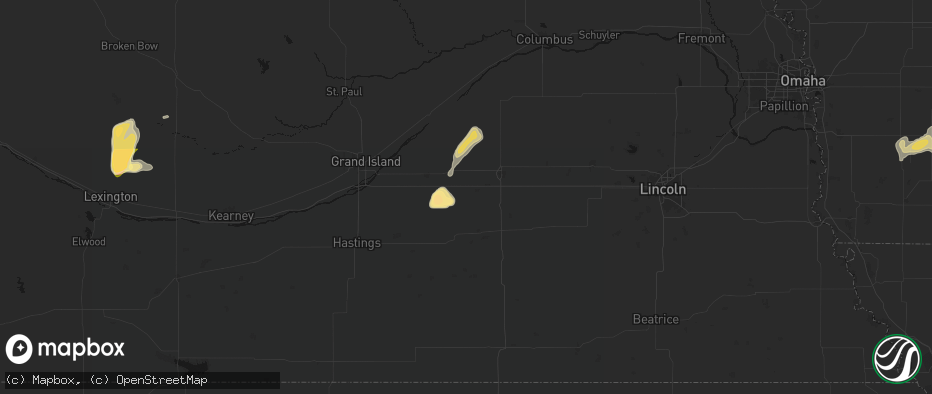
Hail
Wind
Tornado
974
Estimated number of impacted properties by a 1.00" hail or larger844
Estimated number of impacted properties by a 1.75" hail or larger0
Estimated number of impacted properties by a 2.50" hail or largerStorm reports in Henderson, NE
Henderson, NE
| Date | Description |
|---|---|
| 05/16/20265:45 PM CDT | A local report indicates 1.50 inch wind near 2 E Henderson |
| 05/16/20265:42 PM CDT | A local report indicates 1.75 inch wind near Henderson |
| 05/16/20264:52 PM CDT | Actually 1 inch 5/8 inches in diameter. |
| 05/15/20269:34 PM CDT | A local report indicates 65 MPH wind near 2 SW Henderson |
| 05/15/20269:34 PM CDT | A local report indicates 65 MPH wind near 1 SW Henderson |
All States Impacted by Hail Map on May 16, 2026
All Cities Impacted by Hail Map on May 16, 2026
- North Vernon, IN
- Urbana, OH
- Saint Paris, OH
- Springfield, OH
- Saint Anthony, IN
- Huntingburg, IN
- Ferdinand, IN
- Celestine, IN
- Holland, IN
- Eckerty, IN
- Dale, IN
- Schnellville, IN
- Birdseye, IN
- Oblong, IL
- Sumner, IL
- Nelson, MO
- Carrollton, KY
- Vevay, IN
- Madison, IN
- Cable, OH
- Saint Meinrad, IN
- Bristow, IN
- Mechanicsburg, OH
- Canaan, IN
- Blackwater, MO
- Bennington, IN
- Taswell, IN
- English, IN
- Flat Rock, IL
- Bridgeport, IL
- Lawrenceville, IL
- Richwood, OH
- Saint Croix, IN
- Petersburg, IN
- Grantsburg, IN
- Rising Sun, IN
- Florence, IN
- Truxton, MO
- Bellflower, MO
- Moscow Mills, MO
- Old Monroe, MO
- Irwin, OH
- Milford Center, OH
- Silex, MO
- Hawk Point, MO
- Troy, MO
- Winfield, MO
- Jasper, IN
- Bethlehem, KY
- Lockport, KY
- Patriot, IN
- Riceville, IA
- Chester, IA
- McIntire, IA
- Stamping Ground, KY
- Ludlow, MO
- Gilliam, MO
- Slater, MO
- Corinth, KY
- Owenton, KY
- Utica, MO
- Hale, MO
- Chillicothe, MO
- Marshall, MO
- Sadieville, KY
- Cynthiana, KY
- Georgetown, KY
- Dawn, MO
- Salisbury, MO
- Sumner, MO
- Rothville, MO
- Mendon, MO
- Brookfield, MO
- Marceline, MO
- Pittsfield, IL
- Mount Olivet, KY
- Carlisle, KY
- Paris, KY
- Brooksville, KY
- Lock Springs, MO
- Meadville, MO
- Payson, IL
- Winchester, IL
- Meredosia, IL
- Arenzville, IL
- Beardstown, IL
- Gallatin, MO
- Shelbyville, MO
- Jamesport, MO
- Virginia, IL
- Laclede, MO
- Liberty, IL
- Sharpsburg, KY
- Emden, MO
- Bluffs, IL
- Ashland, IL
- Clayton, IL
- Linneus, MO
- Chula, MO
- Timewell, IL
- Palmyra, MO
- Trenton, MO
- Purdin, MO
- Hannibal, MO
- Bucklin, MO
- Mount Sterling, IL
- Quincy, IL
- French Lick, IN
- Winigan, MO
- New Boston, MO
- Paoli, IN
- Versailles, IL
- Hardinsburg, IN
- Milltown, IN
- Marengo, IN
- Plainville, IL
- Barry, IL
- Baylis, IL
- Bethel, MO
- Leonard, MO
- Edina, MO
- Taylor, MO
- La Grange, MO
- Knox City, MO
- Monticello, MO
- Canton, MO
- Mendon, IL
- Ursa, IL
- Coatsburg, IL
- Mulkeytown, IL
- Benton, IL
- Mount Carmel, IL
- Ramah, CO
- Hazleton, IN
- Allendale, IL
- Simla, CO
- Browning, MO
- Saint Francisville, IL
- Matheson, CO
- Monroe City, IN
- Decker, IN
- Vincennes, IN
- Smithton, IL
- Freeburg, IL
- Belleville, IL
- Limon, CO
- Aviston, IL
- Trenton, IL
- Wheatland, IN
- Washington, IN
- Jameson, MO
- Highland, IL
- Pocahontas, IL
- Vandalia, IL
- Patoka, IL
- New Athens, IL
- Vernon, IL
- Carlyle, IL
- Mascoutah, IL
- Germantown, IL
- Albers, IL
- Breese, IL
- Alma, IL
- Kinmundy, IL
- Calhan, CO
- Montgomery, IN
- Bruceville, IN
- Bicknell, IN
- Corydon, IN
- Loogootee, IN
- Saint Peter, IL
- Bartelso, IL
- Beckemeyer, IL
- Sandoval, IL
- Odin, IL
- Wellfleet, NE
- Dickens, NE
- Cannelburg, IN
- Hoyleton, IL
- Centralia, IL
- Salem, IL
- Ragsdale, IN
- Farina, IL
- Lanesville, IN
- Georgetown, IN
- Corning, IA
- Prescott, IA
- North Platte, NE
- Aurora, NE
- New Hampton, MO
- Bethany, MO
- Mount Vernon, IL
- Albany, MO
- Walnut Hill, IL
- Kell, IL
- Dix, IL
- Hugo, CO
- Peru, IA
- Lexington, NE
- Eddyville, NE
- Imogene, IA
- Woodlawn, IL
- Coffey, MO
- Central, IN
- Mauckport, IN
- Louisville, IL
- Depauw, IN
- Sumner, NE
- Marysville, OH
- Nashville, IL
- Gilman City, MO
- Villisca, IA
- Stanton, IA
- Bedford, KY
- Plainville, IN
- Battletown, KY
- West Baden Springs, IN
- Truro, IA
- Edgewood, IL
- Genoa, CO
- Pekin, IN
- Palmyra, IN
- Emerson, IA
- Brush, CO
- Red Oak, IA
- Iuka, IL
- Texico, IL
- New Salisbury, IN
- Ramsey, IN
- Clarinda, IA
- Woodstock, OH
- Ashley, IL
- Zanesfield, OH
- West Liberty, OH
- Pattonsburg, MO
- Bluford, IL
- Arriba, CO
- Ravenwood, MO
- Grant, NE
- Spickard, MO
- Martinsville, MO
- Green Castle, MO
- Green City, MO
- Milan, MO
- Akron, CO
- Bradshaw, NE
- Hampton, NE
- Xenia, IL
- Fredericksburg, IN
- Laredo, MO
- New Market, IA
- Elizabeth, IN
- Overton, NE
- Du Bois, IL
- Princeton, MO
- Saint Charles, IA
- Flora, IL
- Richview, IL
- Mason City, NE
- Madrid, NE
- Louisville, KY
- Hillrose, CO
- Clay City, IL
- Henderson, NE
- Nodaway, IA
- Oconto, NE
- New Albany, IN
- Polk, NE
- Maxwell, NE
- Noble, IL
- Maywood, NE
- Keenes, IL
- Benedict, NE
- Johnsonville, IL
- Salem, IN
- Holyoke, CO
- Atwood, CO
- Galt, MO
- Gravity, IA
- West Liberty, IL
- Stanberry, MO
- Newton, IL
- Ingraham, IL
- Olney, IL
- Merino, CO
- Kanorado, KS
- New Middletown, IN
- Ridgeway, MO
- Amherst, CO
- Sims, IL
- Stromsburg, NE
- Osceola, NE
- Clarksville, IN
- Floyds Knobs, IN
- Sailor Springs, IL
- Glenview, KY
- Prospect, KY
- Jeffersonville, IN
- Dundas, IL
- Flagler, CO
- Curtis, NE
- Miller, NE
- Wayne City, IL
- Burlington, CO
- Elliott, IA
- Sterling, CO
- Moorefield, NE
- Brady, NE
- Ravenna, NE
- Shelton, NE
- Humphreys, MO
- Broken Bow, NE
- Elm Creek, NE
- Amherst, NE
- Champion, NE
- Iliff, CO
- Griswold, IA
- Lenox, IA
- Sharpsburg, IA
- Bedford, IA
- Joes, CO
- Cairo, NE
- Farnam, NE
- Elsie, NE
- Buckner, KY
- Crestwood, KY
- La Grange, KY
- Claremont, IL
- Sellersburg, IN
- Fairfield, IL
- Geff, IL
- Kirk, CO
- Seibert, CO
- Creston, IA
- Masonic Home, KY
- Goshen, KY
- Ansley, NE
- Fleming, CO
- Lineville, IA
- Boelus, NE
- Rockville, NE
- Simpsonville, KY
- Fisherville, KY
- Finchville, KY
- Golden Gate, IL
- Clearfield, IA
- Goodland, KS
- Vona, CO
- York, NE
- Peetz, CO
- Padroni, CO
- Gothenburg, NE
- Silver Creek, NE
- Wheeling, MO
- Pewee Valley, KY
- Barnhill, IL
- Cainsville, MO
- Columbus, NE
- Shelby, NE
- Wallace, NE
- Cozad, NE
- Winona, KS
- Ellery, IL
- Albion, IL
- Carmi, IL
- Grayville, IL
- Burnt Prairie, IL
- Stratton, CO
- Browns, IL
- Corydon, IA
- Allerton, IA
- Bethune, CO
- Essex, IA
- Humeston, IA
- Eminence, KY
- Garden Grove, IA
- Pleasanton, NE
- Loup City, NE
- Litchfield, NE
- Smithfield, KY
- Edson, KS
- Idalia, CO
- Willow Island, NE
- Saint Francis, KS
- Wray, CO
- Pleasureville, KY
- Central City, NE
- Archer, NE
- Chapman, NE
- Platte Center, NE
- Crossville, IL
- Owensville, IN
- Griffin, IN
- Diagonal, IA
- Colby, KS
- Sidney, NE
- Duncan, NE
- Monroe, NE
- Benton, IA
- Blockton, IA
- Brewster, KS
- Levant, KS
- McDonald, KS
- Bird City, KS
- Scotia, NE
- Ord, NE
- Frankfort, KY
- Venango, NE
- Palmer, NE
- New Harmony, IN
- Westerville, NE
- Riverdale, NE
- Kearney, NE
- Hopkins, MO
- Immokalee, FL
- Poseyville, IN
- Arapahoe, CO
- Wallace, KS
- Weskan, KS
- Imperial, NE
- Humphrey, NE
- Creston, NE
- Comstock, NE
- North Loup, NE
- Mount Ayr, IA
- Redding, IA
- Lake Panasoffkee, FL
- Wolbach, NE
- Greeley, NE
- Elmo, MO
- Braddyville, IA
- Clearmont, MO
- Sheridan, MO
- Eustis, NE
- Fullerton, NE
- Kellerton, IA
- Plymouth, NE
- Jansen, NE
- Beatrice, NE
- De Witt, NE
- Sharon Springs, KS
- Gibbon, NE
- Newman Grove, NE
- Belgrade, NE
- Cedar Rapids, NE
- Hayes Center, NE
- Stanton, NE
- Madison, NE
- Hatfield, MO
- Grant City, MO
- Rising City, NE
- Elwood, NE
- Worth, MO
- Arcadia, NE
- Lamoni, IA
- Eagleville, MO
- Elgin, NE
- Swanton, NE
- Agenda, KS
- Clyde, KS
- Gem, KS
- Rexford, KS
- Ashton, NE
- Rock Port, MO
- Gentry, MO
- Stockville, NE
- Denver, MO
- Parnell, MO
- Mercer, MO
- Davis City, IA
- Blythedale, MO
- Branford, FL
- Bell, FL
- Breda, IA
- Maryville, MO
- Pickering, MO
- Atwood, KS
- Oakley, KS
- Monument, KS
- Smithfield, NE
- Wood River, NE
- Wilber, NE
- Hallam, NE
- Crete, NE
- Clatonia, NE
- Burlington Junction, MO
- Labelle, FL
- Moore Haven, FL
- Oakdale, NE
- Petersburg, NE
- Cuba, KS
- Clifton, KS
- Tilden, NE
- Meadow Grove, NE
- Primrose, NE
- Hamburg, IA
- Dwight, NE
- Ulysses, NE
- Bellwood, NE
- Haddam, KS
- David City, NE
- Elba, NE
- Hoxie, KS
- Bertrand, NE
- Albion, NE
- Skidmore, MO
- Oberlin, KS
- Palisade, NE
- Belleville, KS
- Clyde, MO
- Brainard, NE
- Norfolk, NE
- Selden, KS
- Grainfield, KS
- Grinnell, KS
- Loomis, NE
- Alda, NE
- McCook, NE
- Morrowville, KS
- Conception Junction, MO
- Pickrell, NE
- Denton, NE
- Mahaska, KS
- Shenandoah, IA
- Grand Island, NE
- Guilford, MO
- Barnard, MO
- Lindsay, NE
- Brownell, KS
- Campbell, NE
- Bladen, NE
- Doniphan, NE
- Darlington, MO
- Cortland, NE
- McFall, MO
- Milford, NE
- Pleasant Dale, NE
- Lincoln, NE
- King City, MO
- Conception, MO
- Indianola, NE
- Danbury, NE
- Lebanon, NE
- Wilsonville, NE
- Roseland, NE
- Holstein, NE
- Holdrege, NE
- Narka, KS
- Fairbury, NE
- Linn, KS
- Endicott, NE
- Glenvil, NE
- Hastings, NE
- Seward, NE
- Weston, NE
- Pierce, NE
- Hoskins, NE
- Tarkio, MO
- Westboro, MO
- Norton, KS
- Peru, NE
- Giltner, NE
- Phillips, NE
- Reynolds, NE
- Cambridge, NE
- Trumbull, NE
- Malcolm, NE
- Valparaiso, NE
- Morland, KS
- Saint Libory, NE
- Raymond, NE
- Ayr, NE
- Garland, NE
- Hubbell, NE
- Washington, KS
- Wahoo, NE
- Ceresco, NE
- Bartley, NE
- Park, KS
- Quinter, KS
- Collyer, KS
- Wakeeney, KS
- Penokee, KS
- Hill City, KS
- Dresden, KS
- Norcatur, KS
- Arapahoe, NE
- Holbrook, NE
- Almena, KS
- Hendley, NE
- Beaver City, NE
- Oxford, NE
- Stamford, NE
- Edison, NE
- Prairie View, KS
- Orleans, NE
- Long Island, KS
- Phillipsburg, KS
- Lenora, KS
- Funk, NE
- Farragut, IA
- Riverton, IA
- Blue Hill, NE
- Harris, MO
- Filley, NE
- Watson, MO
- Maysville, MO
- Munden, KS
- Marquette, NE
- Waverly, IA
- Tripoli, IA
- Belvidere, NE
- Graham, MO
- Rea, MO
- Sumner, IA
- Tobias, NE
- Western, NE
- Clarks, NE
- Dorchester, NE
- Ashland, NE
- Waverly, NE
- Bee, NE
- Bogue, KS
- Palco, KS
- Damar, KS
- Plainville, KS
- Stockton, KS
- Alma, NE
- Atlanta, NE
- Readlyn, IA
- Denver, IA
- Maitland, MO
- Lawrence, NE
- Minden, NE
- Newtown, MO
- Pollock, MO
- Chester, NE
- Guide Rock, NE
- Deweese, NE
- Fairfield, NE
- Natoma, KS
- Woodston, KS
- Glade, KS
- Agra, KS
- Kensington, KS
- Gaylord, KS
- Republican City, NE
- Kirwin, KS
- Axtell, NE
- Naponee, NE
- Hildreth, NE
- Bloomington, NE
- Wilcox, NE
- Davey, NE
- Sutton, NE
- Ithaca, NE
- Juniata, NE
- Upland, NE
- Hebron, NE
- Yutan, NE
- Adams, NE
- Nelson, NE
- Superior, NE
- Sterling, NE
- Grafton, NE
- Fairmont, NE
- Kenesaw, NE
- Burr, NE
- Douglas, NE
- Waterloo, NE
- Fairfax, MO
- Weatherby, MO
- Fairbank, IA
- Gilead, NE
- Edgar, NE
- Oelwein, IA
- Gretna, NE
- Hazleton, IA
- Cedar, KS
- Athol, KS
- Franklin, NE
- Riverton, NE
- Smith Center, KS
- Heartwell, NE
- McCool Junction, NE
- Hordville, NE
- Oak, NE
- Shickley, NE
- Strang, NE
- Milligan, NE
- Waco, NE
- Bolckow, MO
- Unionville, MO
- Geneva, NE
- Carleton, NE
- Alexandria, NE
- Friend, NE
- Beaver Crossing, NE
- Bruning, NE
- Lebanon, KS
- Red Cloud, NE
- Mankato, KS
- Burr Oak, KS
- Inavale, NE
- Esbon, KS
- Utica, NE
- Gresham, NE
- Staplehurst, NE
- Exeter, NE
- Surprise, NE
- Goehner, NE
- Cordova, NE
- Ohiowa, NE
- Tecumseh, NE
- Blue Springs, NE
- Manchester, IA
- Dundee, IA
- Greenwood, NE
- Davenport, NE
- Jewell, KS
- Inland, NE
- Dyersville, IA
- Earlville, IA
- Greeley, IA
- New Vienna, IA
- Edgewood, IA
- Memphis, NE
- Union Star, MO
- Charlestown, IN
- Westport, KY
- Bethlehem, IN
- Pendleton, KY
- New Washington, IN
- Republic, KS
- Peterson, IA
- Hardy, NE
- Courtland, KS
- Webber, KS
- Deshler, NE
- Sulphur, KY
- Campbellsburg, KY
- New Castle, KY
- Ruskin, NE
- Cook, NE
- Beloit, KS
- Oregon, MO
- Hunter, KS
- Sylvan Grove, KS
- Turners Station, KY
- Sanders, KY
- Worthville, KY
- Ghent, KY
- Glen Elder, KS
- Cawker City, KS
- Randall, KS
- Clay Center, NE
- Harvard, NE
- Concordia, KS
- Norway, KS
- Byron, NE
- Formoso, KS
- Scandia, KS
- Jamestown, KS
- Aurora, KS
- Glasco, KS
- Daykin, NE
- Arbela, MO
- Luray, MO
- Memphis, MO
- Rutledge, MO
- Gorin, MO
- Luxemburg, IA
- Guttenberg, IA
- Ong, NE
- Saronville, NE
- Saint Paul, NE
- Dannebrog, NE
- Palmer, KS
- Morganville, KS
- Green, KS
- Clay Center, KS
- Talmage, NE
- Brock, NE
- Johnson, NE
- Delphos, KS
- Novinger, MO
- Fillmore, MO
- Miltonvale, KS
- Wakefield, KS
- Diller, NE
- Hollenberg, KS
- Steele City, NE
- Hanover, KS
- Greenleaf, KS
- Randolph, KS
- Odell, NE
- Lucerne, MO
- Savannah, MO
- Nebraska City, NE
- Julian, NE
- Leonardville, KS
- Barnes, KS
- Bremen, KS
- Waterville, KS
- Martell, NE
- Rosendale, MO
- Auburn, NE
- Wymore, NE
- Marysville, KS
- Beattie, KS
- Oketo, KS
- Helena, MO
- Roca, NE
- Sprague, NE
- Hickman, NE
- Panama, NE
- Liberty, NE
- Bennet, NE
- Lewiston, NE
- Barneston, NE
- Crab Orchard, NE
- Summerfield, KS
- Firth, NE
- Blue Rapids, KS
- Steinauer, NE
- Home, KS
- Burchard, NE
- Virginia, NE
- Frankfort, KS
- Pawnee City, NE
- Elk Creek, NE
- Westmoreland, KS
- Centralia, KS
- Axtell, KS
- Table Rock, NE
- Onaga, KS
- Vermillion, KS
- Olsburg, KS
- Baileyville, KS
- Bern, KS
- Humboldt, NE
- Du Bois, NE
- Corning, KS
- Goff, KS
- Seneca, KS
- Havensville, KS
- Oneida, KS
- Syracuse, NE
- Sabetha, KS
- Stella, NE
- Nemaha, NE
- Verdon, NE
- Shubert, NE
- Dawson, NE
- Brownville, NE
- Soldier, KS
- Circleville, KS
- Falls City, NE
- Wetmore, KS
- Morrill, KS
- Holton, KS
- Fairview, KS
- Powhattan, KS
- Salem, NE
- Netawaka, KS
- Whiting, KS
- Hiawatha, KS
- White Cloud, KS
- Rulo, NE
- Horton, KS
- Craig, MO
- Effingham, KS
- Highland, KS
- Denton, KS
- Muscotah, KS
- Troy, KS
- Lancaster, KS
- Everest, KS
- Robinson, KS
- Hull, IA
- Rock Valley, IA
- Forest City, MO
- Mound City, MO
- Atchison, KS
- Bendena, KS
- Cummings, KS
- Nortonville, KS
- Valley Falls, KS
- Hershey, NE
- Sutherland, NE
- Paxton, NE
- Columbus, WI
- Fall River, WI
- Rio, WI
- Hazard, NE
- Farwell, NE


