Hail Map in South Dakota on May 24, 2026
The weather event in South Dakota on May 24, 2026 includes Hail and Wind maps. 10 states and 263 cities were impacted and suffered possible damage. The total estimated number of properties impacted is 27,574.
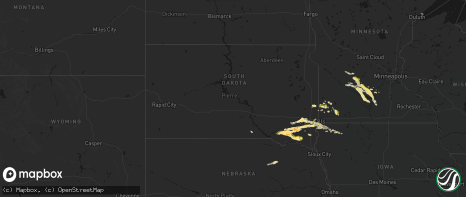
Hail
Wind
27,574
Estimated number of impacted properties by a 1.00" hail or larger4,140
Estimated number of impacted properties by a 1.75" hail or larger0
Estimated number of impacted properties by a 2.50" hail or largerStorm reports in South Dakota
South Dakota
| Date | Description |
|---|---|
| 05/24/20266:51 PM CDT | Corrects previous hail report from 5 s scotland. Off duty nssl employee reported ping pong ball size hail. |
| 05/24/20266:50 PM CDT | A local report indicates 1.25 inch wind near Scotland |
| 05/24/20266:35 PM CDT | Report via social media... Time estimated by radar. |
| 05/24/20265:58 PM CDT | A local report indicates 1.75 inch wind near 6 NW Scotland |
| 05/24/20265:55 PM CDT | A local report indicates 2.00 inch wind near 7 E Tripp |
| 05/24/20265:40 PM CDT | A local report indicates 1.75 inch wind near 3 ENE Tripp |
| 05/24/20265:26 PM CDT | Sheriff reported half dollar size hail. |
| 05/24/20265:11 PM CDT | A local report indicates 1.00 inch wind near 6 WSW Tripp |
| 05/24/20267:52 AM CDT | Report via social media. Hail ranged from penny... To nickel... With a few quarter size stones in town. |
| 05/23/202611:40 PM CDT | Mping report of quarter |
| 05/23/202611:30 PM CDT | Got an mping report of quarter sized hail in sioux falls. Time estimated via radar. |
| 05/23/202611:11 PM CDT | Report from social media... Time estimated by radar. |
| 05/23/202610:22 PM CDT | Received a public report of quarter sized hail near harrisburg. Time estimated via radar. |
| 05/23/202610:18 PM CDT | Report from social media. Time estimated by radar. |
| 05/23/20269:38 PM CDT | Report from social media. Time estimated by radar. |
| 05/23/20269:05 PM CDT | Freeman fire rescue reported pea to ping-pong ball sized hail in freeman. Time was estimated via radar. |
| 05/23/20269:05 PM CDT | Received a photo of 2 inch hail in freeman via social media. Timing was estimated from radar. |
| 05/23/20268:10 PM CDT | A local report indicates 1.50 inch wind near 5 WSW Mayfield |
| 05/23/20268:01 PM CDT | A local report indicates 1.50 inch wind near 3 ESE Menno |
| 05/23/20267:52 PM CDT | Corrects previous hail report from flandreau. Report via social media. Hail ranged from penny... To nickel... With a few quarter size stones in town. |
| 05/23/20267:47 PM CDT | A local report indicates 1.00 inch wind near 4 N Utica |
| 05/23/20267:06 PM CDT | Off duty nssl employee reported ping pong ball size hail. |
All States Impacted by Hail Map on May 24, 2026
Cities Impacted by Hail Map on May 24, 2026
- Graettinger, IA
- Weatherford, OK
- Custer City, OK
- Clinton, OK
- Thomas, OK
- Arapaho, OK
- Putnam, OK
- Thomaston, GA
- Armstrong, TX
- Kerens, TX
- Justin, TX
- Crandall, TX
- Scurry, TX
- Kemp, TX
- Folkston, GA
- Kaufman, TX
- Hilliard, FL
- Fort Worth, TX
- Haslet, TX
- Mabank, TX
- Seagoville, TX
- Lyford, TX
- Ferris, TX
- North Richland Hills, TX
- Raymondville, TX
- San Perlita, TX
- Bedford, TX
- Hurst, TX
- Colleyville, TX
- Rhome, TX
- Punta Gorda, FL
- Duluth, MN
- Haltom City, TX
- Eustace, TX
- Comanche, TX
- Rosser, TX
- Euless, TX
- Desoto, TX
- Duncanville, TX
- Arlington, TX
- Lancaster, TX
- Grand Prairie, TX
- Red Oak, TX
- San Benito, TX
- Decatur, TX
- Lipan, TX
- Stephenville, TX
- Athens, TX
- Kathleen, FL
- Lakeland, FL
- Wagner, SD
- Delmont, SD
- Dallas, TX
- Glennville, GA
- Ambrose, GA
- Sacred Heart, MN
- Cedar Hill, TX
- Los Fresnos, TX
- Lake Lillian, MN
- Olivia, MN
- Dade City, FL
- Larue, TX
- Murchison, TX
- Hector, MN
- Cosmos, MN
- Bird Island, MN
- Tripp, SD
- Avon, SD
- Renville, MN
- Zephyrhills, FL
- Alvord, TX
- Alachua, FL
- Broxton, GA
- Irving, TX
- Buffalo Lake, MN
- Denton, GA
- Sunset, TX
- Danube, MN
- Wray, GA
- Granbury, TX
- Cresson, TX
- Stollings, WV
- Switzer, WV
- Logan, WV
- Chauncey, WV
- Junction, TX
- Redwood Falls, MN
- Lumber City, GA
- Hazlehurst, GA
- Lyburn, WV
- Yolyn, WV
- Weatherford, TX
- Harper, TX
- Pembroke, GA
- Statesboro, GA
- Palestine, TX
- Montalba, TX
- Kaylor, SD
- Pipestone, MN
- Stewart, MN
- Forestburg, TX
- Alamo, GA
- Aledo, TX
- Arlington, MN
- Gaylord, MN
- Canton, TX
- Franklin, MN
- McRae Helena, GA
- Holland, MN
- Scotland, SD
- Olivet, SD
- Mountain Home, TX
- Bowie, TX
- Gibbon, MN
- Winthrop, MN
- Fairfax, MN
- Edgerton, MN
- Woodstock, MN
- Gorman, TX
- Desdemona, TX
- Bushnell, FL
- Freeman, SD
- Emery, SD
- Menno, SD
- Lesterville, SD
- Soperton, GA
- Vidalia, GA
- Canistota, SD
- Ranger, TX
- Dublin, TX
- Brooksville, FL
- Fredericksburg, TX
- Eden, TX
- Willmar, MN
- Brownton, MN
- Raymond, MN
- Bridgewater, SD
- Chambers, NE
- Tarrytown, GA
- Marion, SD
- Carbon, TX
- New Ulm, MN
- Belfry, KY
- Sidney, KY
- Forest Hills, KY
- South Williamson, KY
- Williamson, WV
- Lafayette, MN
- Nicollet, MN
- Saint Peter, MN
- Kerkhoven, MN
- Santo, TX
- Eastland, TX
- Ewing, NE
- Dudley, GA
- Swainsboro, GA
- Humboldt, SD
- Le Sueur, MN
- Perrin, TX
- Morriston, FL
- Palo Pinto, TX
- Montrose, SD
- Jasper, MN
- Gordon, TX
- Mingus, TX
- Le Center, MN
- Strawn, TX
- Courtland, MN
- Fulda, MN
- Iona, MN
- Graford, TX
- Lake Wilson, MN
- Tyndall, SD
- Lake Crystal, MN
- Hanska, MN
- Worthington, MN
- Slayton, MN
- Carlton, GA
- Bowman, GA
- Egan, SD
- Mankato, MN
- Utica, SD
- Flandreau, SD
- Hartford, SD
- Chandler, MN
- Leota, MN
- Hardwick, MN
- Clearwater, NE
- Ruthton, MN
- Williston, FL
- Balaton, MN
- Reading, MN
- Kasota, MN
- Gregory, SD
- Graham, TX
- Elberton, GA
- Yankton, SD
- Centerville, SD
- Burke, SD
- Archer, FL
- Micanopy, FL
- Eagle Lake, MN
- Medina, TX
- Beresford, SD
- Mission Hill, SD
- Irene, SD
- Volin, SD
- Brewster, MN
- High Springs, FL
- Mineral Wells, TX
- Crockett, TX
- Wakonda, SD
- Vermillion, SD
- Cisco, TX
- Gustine, TX
- Hurley, SD
- Bandera, TX
- Santa Anna, TX
- Parker, SD
- Hico, TX
- Early, TX
- Cross Plains, TX
- Burkett, TX
- Brownwood, TX
- Bangs, TX
- Chancellor, SD
- Alcester, SD
- Coleman, TX
- Lennox, SD
- Tea, SD
- Harrisburg, SD
- Worthing, SD
- Sioux Falls, SD
- Monroe, SD
- Canton, SD
- Larchwood, IA
- Inwood, IA
- Mullin, TX
- Alvord, IA
- Goldthwaite, TX
- Priddy, TX
- Davis, SD
- Brandon, SD
- Valley Springs, SD
- Richland Springs, TX
- Doon, IA
- Hull, IA
- San Saba, TX
- Rock Rapids, IA
- Rochelle, TX
- Boyden, IA
- Lester, IA
- Sheldon, IA
- George, IA
- Peterson, IA
- Lometa, TX
- Ashton, IA
- Sanborn, IA
- Rising Star, TX
- Hartley, IA
- May, TX
- Henderson, MN
- Green Isle, MN


