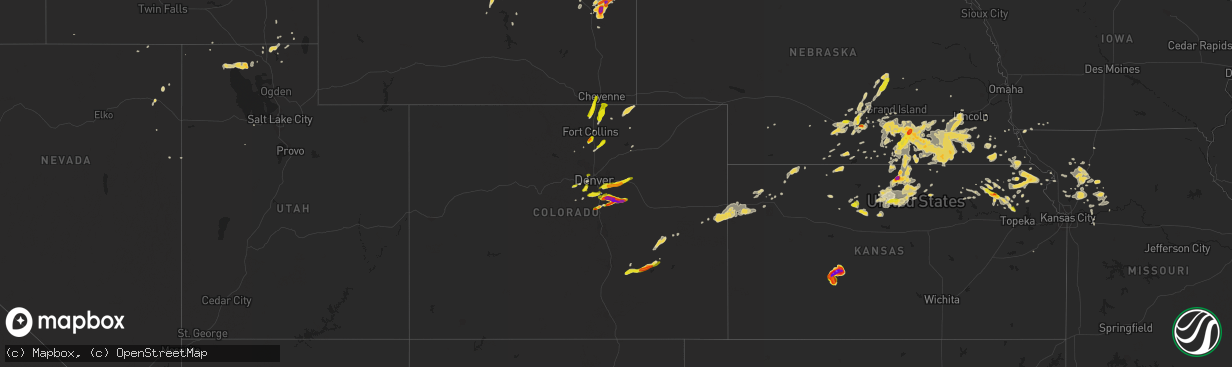
Hail Map on June 3, 2015
The weather event on June 3, 2015 includes Hail map. 18 states and 565 cities were impacted and suffered possible damage. The total estimated number of properties impacted is 142,903.
Hail
142,903
Estimated number of impacted properties by a 1.00" hail or larger13,149
Estimated number of impacted properties by a 1.75" hail or larger1,184
Estimated number of impacted properties by a 2.50" hail or largerStates Impacted by Hail Map on June 3, 2015
Storm reports
Utah
| Date | Description |
|---|---|
| 06/03/20156:40 PM CDT | North salt flats sensor dpg25 |
| 06/02/20159:50 PM CDT | Trees down |
| 06/02/20159:45 PM CDT | Downed tree branches...irrigation system blown on to the side of the road and roll-over on interstate 15 from thunderstorm winds. |
| 06/02/20159:40 PM CDT | I-15 at plymouth |
| 06/02/20159:30 PM CDT | Baccus highway - 5172 ft |
| 06/02/20159:30 PM CDT | Mountain view at dannon way - 4910 ft |
| 06/02/20159:25 PM CDT | Trans-jordan landfill - 5201 ft |
| 06/02/20159:25 PM CDT | Large tree down on vehicle |
| 06/02/20159:20 PM CDT | Legacy parkway - 4215 ft |
| 06/02/20159:20 PM CDT | I-15 at tremonton - 4295 ft |
| 06/02/20159:15 PM CDT | Promontory point - 6926 ft |
| 06/02/20159:05 PM CDT | Promontory point - 6926 ft |
| 06/02/20158:50 PM CDT | A local report indicates 1.50 inch wind near PROMONTORY |
| 06/02/20158:50 PM CDT | A local report indicates 60 MPH wind near PROMONTORY |
| 06/02/20158:37 PM CDT | A local report indicates 1.00 inch wind near CLARKSTON |
| 06/02/20158:20 PM CDT | Curlew junction sensor utcur |
| 06/02/20158:10 PM CDT | Curlew junction sensor utcur |
| 06/02/20158:00 PM CDT | Center tailings sensor kcc13 |
Nebraska
| Date | Description |
|---|---|
| 06/03/20155:52 AM CDT | Gusts estimated greater than 60 mph. Tree branches were blown down. |
| 06/03/20155:29 AM CDT | County dispatch reports nickel to quarter size hail |
| 06/03/20154:39 AM CDT | Quarter size hail and also estimated gusts to 60 mph |
| 06/03/20153:41 AM CDT | A few stones up to quarter size...along showboat road on east side of town |
| 06/03/20152:45 AM CDT | Quarter to half dollar size hail...relayed by broadcast media. |
| 06/03/20151:42 AM CDT | A local report indicates 1.00 inch wind near 3 S KEARNEY |
| 06/03/20151:00 AM CDT | Dime to quarter size at dove hill avenue and highway 30. Facebook report. |
| 06/02/201511:36 PM CDT | Law enforcement reported heavy hail with approximately 30 percent the size of golf balls near church street. |
| 06/02/201511:35 PM CDT | A local report indicates 1.00 inch wind near CLAY CENTER |
| 06/02/201511:27 PM CDT | A local report indicates 1.00 inch wind near FAIRFIELD |
Colorado
| Date | Description |
|---|---|
| 06/03/20156:45 PM CDT | A local report indicates 1.00 inch wind near SW ARVADA |
| 06/03/20156:22 PM CDT | E470 and chambers |
| 06/03/20156:12 PM CDT | A local report indicates 1.50 inch wind near 5 SE FRANKTOWN |
| 06/03/20156:10 PM CDT | A local report indicates 1.00 inch wind near 4 E ELIZABETH |
| 06/03/20156:08 PM CDT | A local report indicates 1.75 inch wind near 5 SE FRANKTOWN |
| 06/03/20156:06 PM CDT | A local report indicates 1.25 inch wind near 3 SSW ELIZABETH |
| 06/03/20156:05 PM CDT | A local report indicates 1.25 inch wind near 1 NW LOUVIERS |
| 06/03/20156:03 PM CDT | A local report indicates 1.75 inch wind near ELIZABETH |
| 06/03/20155:59 PM CDT | A local report indicates 1.00 inch wind near 1 S AGATE |
| 06/03/20155:48 PM CDT | A local report indicates 1.00 inch wind near ELIZABETH |
| 06/03/20154:56 PM CDT | A local report indicates 1.00 inch wind near 3 NNE LARKSPUR |
| 06/03/20154:35 PM CDT | A local report indicates 1.25 inch wind near 3 ESE PERRY PARK |
| 06/03/20154:30 PM CDT | A local report indicates 1.75 inch wind near 4 NNW LARKSPUR |
| 06/03/201512:33 AM CDT | A local report indicates 1.75 inch wind near 3 N ORDWAY |
| 06/02/201510:18 PM CDT | A local report indicates 1.00 inch wind near BENNETT |
| 06/02/201510:07 PM CDT | A local report indicates 1.25 inch wind near 5 S BENNETT |
| 06/02/201510:07 PM CDT | A local report indicates 1.25 inch wind near 5 W COUNTRY GARDENS |
| 06/02/201510:02 PM CDT | A local report indicates 1.50 inch wind near 5 S BENNETT |
| 06/02/20159:33 PM CDT | Hail busted the windshield of the chase vehicle. |
| 06/02/20158:54 PM CDT | A local report indicates 1.00 inch wind near SE AURORA |
| 06/02/20158:51 PM CDT | A local report indicates 1.25 inch wind near CENTENNIAL |
| 06/02/20158:45 PM CDT | Siding to home was damaged and screens torn up. |
| 06/02/20158:45 PM CDT | A local report indicates 1.00 inch wind near 5 ENE CENTENNIAL |
| 06/02/20158:38 PM CDT | A local report indicates 1.25 inch wind near LOVELAND |
| 06/02/20158:25 PM CDT | A local report indicates 1.00 inch wind near 14 SSE FORT COLLINS |
| 06/02/20157:48 PM CDT | A local report indicates 1.50 inch wind near 2 N KIOWA |
| 06/02/20157:45 PM CDT | A local report indicates 1.75 inch wind near 3 ENE ELIZABETH |
| 06/02/20157:42 PM CDT | A local report indicates 2.50 inch wind near 3 ENE ELIZABETH |
| 06/02/20157:40 PM CDT | A local report indicates 1.00 inch wind near 2 N ELIZABETH |
| 06/02/20157:38 PM CDT | A local report indicates 2.00 inch wind near ELIZABETH |
| 06/02/20157:28 PM CDT | A local report indicates 1.75 inch wind near ELIZABETH |
| 06/02/20157:28 PM CDT | Golfball hail was breaking windows. |
| 06/02/20157:25 PM CDT | A local report indicates 1.50 inch wind near 4 N ELIZABETH |
| 06/02/20157:20 PM CDT | A local report indicates 1.00 inch wind near 3 WNW EVERGREEN |
| 06/02/20157:16 PM CDT | Golfball hail from 611-616 mdt |
| 06/02/20157:15 PM CDT | A local report indicates 1.00 inch wind near 5 E PARKER |
| 06/02/20157:12 PM CDT | A local report indicates 1.50 inch wind near 3 WSW PONDEROSA PARK |
| 06/02/20157:09 PM CDT | A local report indicates 1.25 inch wind near 3 SSE THE PINERY |
| 06/02/20157:05 PM CDT | Some cars dented by hail... Leaves shredded from trees. |
| 06/02/20157:05 PM CDT | Some pine trees damaged and deciduous trees shredded with severe plant damage also reported. |
Missouri
| Date | Description |
|---|---|
| 06/03/20151:23 PM CDT | Hh highway and bethel rd closed due to trees into power lines over the roadway |
Wyoming
| Date | Description |
|---|---|
| 06/03/20156:54 PM CDT | A trained spotter reported quarter size hail at midwest. |
| 06/03/20156:29 PM CDT | Law enforcement reported ping pong ball size hail near the intersection of us 20-26 and bucknum road. |
| 06/03/201512:55 AM CDT | A local report indicates 62 MPH wind near 17 WSW WRIGHT |
| 06/02/201511:30 PM CDT | Ping pong ball to golf ball size hail. |
| 06/02/20159:50 PM CDT | A local report indicates 2.00 inch wind near 8 NE GLENDO RESERVOIR M |
| 06/02/20158:20 PM CDT | A local report indicates a tornado near 3 S SAVAGETON |
| 06/02/20157:51 PM CDT | A trained spotter reported quarter size hail. |
South Carolina
| Date | Description |
|---|---|
| 06/03/20156:07 PM CDT | Trees down along tokeena road. Time estimated by radar. |
| 06/03/20155:35 PM CDT | Falcons lair golf course had high wind and lost a few trees. |
| 06/03/20154:56 PM CDT | Quarter sized hail reported in the boones creek area northeast of salem and west of lake keowee. |
| 06/02/20157:10 PM CDT | 2 trees down in the same area...one along interstate 85 and the other on phillips road. |
Florida
| Date | Description |
|---|---|
| 06/03/20154:40 PM CDT | Tree down on st johns road |
Kansas
| Date | Description |
|---|---|
| 06/03/20153:48 PM CDT | A local report indicates 1.00 inch wind near 2 W HOYT |
| 06/03/20153:22 PM CDT | A local report indicates 1.75 inch wind near ONAGA |
| 06/03/20152:40 PM CDT | A local report indicates 1.00 inch wind near 6 NW ONAGA |
| 06/02/201510:42 PM CDT | Via storm chaser report and video posted to twitter. Location estimated from radar data. |
| 06/02/201510:28 PM CDT | Brief touchdown of a tornado |
| 06/02/201510:25 PM CDT | Reports of damage to one home...along with outbuildings and trees just west of tipton. Possible tornado damage but not confirmed at this time. Time approximate. |
| 06/02/201510:13 PM CDT | Nickel to quarter size hail at the time of report |
| 06/02/201510:03 PM CDT | Very little wind. 0.91 inches of rain so far. |
| 06/02/20159:58 PM CDT | Hail was starting to cover the ground during call |
| 06/02/20159:30 PM CDT | A local report indicates 1.75 inch wind near 7 NW BELLEFONT |
| 06/02/20159:19 PM CDT | Cloud to ground lightning also reported |
| 06/02/20159:10 PM CDT | A local report indicates 1.75 inch wind near 6 S HANSTON |
| 06/02/20159:02 PM CDT | A local report indicates 1.25 inch wind near 7 S HANSTON |
| 06/02/20158:49 PM CDT | Hail as large as quarters began at 842 pm. Mostly dime sized. |
| 06/02/20158:35 PM CDT | A local report indicates 1.50 inch wind near 4 SW HANSTON |
| 06/02/20158:05 PM CDT | A local report indicates 2.75 inch wind near HANSTON |
| 06/02/20158:02 PM CDT | A local report indicates 1.00 inch wind near 4 E CODELL |
| 06/02/20157:45 PM CDT | A local report indicates 1.75 inch wind near 3 N HANSTON |
| 06/02/20157:35 PM CDT | A local report indicates 2.50 inch wind near 1 S BURDETT |
| 06/02/20157:30 PM CDT | A local report indicates 2.00 inch wind near BURDETT |
| 06/02/20157:30 PM CDT | A local report indicates 1.25 inch wind near 3 NNE GRAY |
| 06/02/20157:30 PM CDT | Most of the hail was about the size of quarters. |
| 06/02/20157:20 PM CDT | A local report indicates 1.75 inch wind near 3 NW BURDETT |
South Dakota
| Date | Description |
|---|---|
| 06/03/20157:28 AM CDT | A local report indicates 1.25 inch wind near 5 NNW COLMAN |
| 06/03/20155:50 AM CDT | 2.28 rainfall and drifts of pea size hail |
| 06/03/20155:45 AM CDT | Heavy rain and pea size hail |
| 06/03/20154:05 AM CDT | A local report indicates 60 MPH wind near 12 E OELRICHS |
| 06/03/20153:45 AM CDT | Rainfall 2.05 inch |
| 06/03/20153:20 AM CDT | A local report indicates 64 MPH wind near 8 W JEWEL CAVE |
| 06/03/20153:20 AM CDT | A local report indicates 64 MPH wind near 8 W JEWEL CAVE |
Idaho
| Date | Description |
|---|---|
| 06/02/20158:45 PM CDT | Report came from the itd site at the juniper interchange. |
| 06/02/20158:00 PM CDT | Picture submitted to the herald journal facebook page post event. |
North Carolina
| Date | Description |
|---|---|
| 06/03/20151:00 AM CDT | A brief ef-0 tornado touched down on soundside road damaging several homes. Damage is consistent with wind speeds approximately 75-80 mph. |
Nevada
| Date | Description |
|---|---|
| 06/03/20155:35 PM CDT | Video sent in showed estimated quarter to half dollar sized falling on interstate 80 near pequop summit. |
Georgia
| Date | Description |
|---|---|
| 06/03/20156:55 PM CDT | Camden county 911 dispatch reports a tree downed by strong wind gusts across new post road just north of tarboro. |
| 06/03/20156:42 PM CDT | Large tree down on highway 129. |
| 06/03/20156:39 PM CDT | Tree down near the intersection of mt pleasant road and lancaster road |
| 06/03/20156:35 PM CDT | Tree down on cook road |
| 06/03/20156:15 PM CDT | Tree down on highway 76 |
| 06/03/20156:15 PM CDT | Tree down on rogers ave in nashville |
| 06/03/20156:15 PM CDT | Tree down near the intersection of radio station road and mark watson road |
| 06/03/20155:52 PM CDT | Trees down in the sandy cross region. Also had reports of small hail covering the ground making it look as if it snowed. |
| 06/03/20155:32 PM CDT | Numerous trees down. Reports of at least 6 to 8 with reports still coming in to ema. |
| 06/03/20155:10 PM CDT | Social media picture of hail estimated at around hen egg size or 2 inches in diameter from brookfield |
| 06/03/20155:10 PM CDT | Quarter sized hail reported east of tifton |
| 06/03/20155:07 PM CDT | Roof and siding damage due to large hail in the vanceville area |
| 06/03/20155:07 PM CDT | Trees down in the vanceville area |
| 06/03/20155:01 PM CDT | Large and small tree limbs down in various places around jesup |
| 06/03/20155:00 PM CDT | Trees snapped or uprooted and large trees down on power line near country club |
| 06/03/20154:55 PM CDT | A couple of trees down around paulk road and highway 319 |
| 06/03/20154:30 PM CDT | Golf ball sized hail reported near the white county border. |
| 06/03/20154:30 PM CDT | Dime to quarter sized hail fell for about 15 minutes at this location on majestic way near clarkesville. Strong wind but no damage was obvious at the time of the call. |
| 06/03/20154:26 PM CDT | Dime to up to quarter sized hail fell briefly in sautee. Report from a hotel clerk in sautee |
| 06/03/20154:25 PM CDT | Trees and powerlines reported down in the jesup city limits. Update...dispatch reported around 40 trees downed near wayne county country club in the jesup city limits a |
| 06/03/20154:09 PM CDT | Lots of trees down. Several on i-20 at mile marker 125. Traffic still backed up as of 6pm. |
| 06/03/20154:02 PM CDT | Web report of quarter sized hail |
| 06/03/20153:56 PM CDT | Dime to golf ball sized hail falling at i85 exit in newnan. Time estimated from radar |
| 06/03/20153:54 PM CDT | A local report indicates 1.00 inch wind near NEWNAN |
| 06/03/20153:38 PM CDT | Several trees blown down in the area off tommy lee cook road and cainbridge park drive |
| 06/03/20153:25 PM CDT | A local report indicates 1.00 inch wind near 2 W PALMETTO |
| 06/03/20152:26 PM CDT | Public reported quarter size hail and gusty winds along cypress lake rd. |
| 06/03/20152:21 PM CDT | Spotter reported quarter size hail and 4 inch branches down along langston chapel rd. |
| 06/03/20151:55 PM CDT | Dime to quarter size hail fell between 255pm and 310pm. Reported by public and twiggs 911 |
| 06/03/20151:55 PM CDT | Numerous trees down blocking roads near jeffersonville. Very near kjgx radar as well as durham mill rd and us 80. |
| 06/03/20151:41 PM CDT | Trees down on salt creek rd near highway 17. |
| 06/03/20151:10 PM CDT | Numerous trees and power lines down near uvalda hwy |
| 06/02/20158:00 PM CDT | Numerous large trees down across the area. |
| 06/02/20157:45 PM CDT | Numerous trees down across the area. |
Cities Impacted by Hail Map on June 3, 2015
- Lumber City, GA
- Uvalda, GA
- Hazlehurst, GA
- Hiawatha, KS
- Troy, KS
- Everest, KS
- Robinson, KS
- Denton, KS
- Aurora, CO
- Watkins, CO
- Bennett, CO
- Byers, CO
- Strasburg, CO
- Downs, KS
- Osborne, KS
- Dry Branch, GA
- Macon, GA
- Scotia, NE
- Wolbach, NE
- Rockville, NE
- Greeley, NE
- Ashton, NE
- Farwell, NE
- Boelus, NE
- Elba, NE
- Lexington, GA
- Carlton, GA
- Midwest, WY
- Waldo, KS
- Luray, KS
- West Union, SC
- Walhalla, SC
- Pawnee City, NE
- Steinauer, NE
- Burchard, NE
- Hamilton, MO
- Jeffrey City, WY
- Hortense, GA
- Screven, GA
- Jesup, GA
- Lusk, WY
- Manville, WY
- Lawrence, NE
- Tifton, GA
- Jetmore, KS
- Ness City, KS
- Larned, KS
- Spearville, KS
- Burdett, KS
- Hanston, KS
- Nelson, NE
- Hardy, NE
- Ruskin, NE
- Superior, NE
- Mankato, KS
- Edgar, NE
- Sundance, WY
- Decker, MT
- Lodge Grass, MT
- Milford, NE
- Bristol, GA
- Odum, GA
- McCormick, SC
- Clarkesville, GA
- Sautee Nacoochee, GA
- Oelrichs, SD
- Hot Springs, SD
- Smithwick, SD
- Edgemont, SD
- Glenrock, WY
- Tellico Plains, TN
- Seneca, SC
- Salem, SC
- Augusta, GA
- Grovetown, GA
- Kaycee, WY
- Edson, KS
- Goodland, KS
- Barnesville, GA
- Grand Island, NE
- Gillette, WY
- Riverdale, NE
- Pleasanton, NE
- Burlington, CO
- Weskan, KS
- Kanorado, KS
- Plattsburg, MO
- Glen Elder, KS
- Tipton, KS
- Kiowa, CO
- Elizabeth, CO
- Franktown, CO
- Castle Rock, CO
- Parker, CO
- Long Island, KS
- Prairie View, KS
- Almena, KS
- Oberlin, KS
- Canon, GA
- Royston, GA
- Bowersville, GA
- Grafton, NE
- Sutton, NE
- Fairmont, NE
- Lincoln, NE
- Crete, NE
- Denton, NE
- Dorchester, NE
- Pleasant Dale, NE
- Morrison, CO
- Littleton, CO
- De Witt, NE
- Clatonia, NE
- Wilber, NE
- Western, NE
- Cortland, NE
- Plainville, KS
- Stockton, KS
- Jamestown, KS
- Jewell, KS
- Onaga, KS
- Wellington, CO
- Casper, WY
- Kearney, NE
- Axtell, NE
- Montrose, GA
- Danville, GA
- Havensville, KS
- Westmoreland, KS
- Frankfort, KS
- Moreland, GA
- Newnan, GA
- Plum Branch, SC
- Stephens, GA
- Palmetto, GA
- Clay Center, NE
- Bertrand, NE
- Porcupine, SD
- Wanblee, SD
- Kyle, SD
- Arlington, GA
- Hiawassee, GA
- Hayesville, NC
- Vermillion, KS
- Evergreen, CO
- Golden, CO
- Trenton, UT
- Clarkston, UT
- Cornish, UT
- Plymouth, UT
- Hallam, NE
- Glendo, WY
- Powhattan, KS
- Fairview, KS
- Larkspur, CO
- Colman, SD
- Flandreau, SD
- Jeffersonville, GA
- Fairbury, NE
- Daykin, NE
- Alexandria, NE
- Carleton, NE
- Jansen, NE
- Hebron, NE
- Belvidere, NE
- Hubbell, NE
- Davenport, NE
- Gilead, NE
- Reynolds, NE
- Bruning, NE
- Tobias, NE
- Plymouth, NE
- Esbon, KS
- Burr Oak, KS
- Valdosta, GA
- Green, KS
- Randolph, KS
- Rebecca, GA
- Westminster, SC
- Cheyenne, WY
- Lathrop, MO
- Greensboro, GA
- Eatonton, GA
- Buckhead, GA
- Keysville, GA
- Karval, CO
- Sugar City, CO
- Minden, NE
- Enigma, GA
- Alapaha, GA
- Grover, CO
- Hastings, NE
- Big Timber, MT
- Corinne, UT
- Snowville, UT
- Kidder, MO
- Cameron, MO
- Harrison, NE
- Roseland, NE
- Bladen, NE
- Loomis, NE
- Holt, MO
- Kearney, MO
- Lawson, MO
- Table Rock, NE
- Doniphan, NE
- Arapahoe, CO
- Sharon Springs, KS
- Lexington, NE
- Smithfield, NE
- Elwood, NE
- Overton, NE
- Elm Creek, NE
- Holton, KS
- Townville, SC
- Anderson, SC
- Odessa, NE
- Wood River, NE
- Dubois, WY
- Centralia, KS
- Moorcroft, WY
- Bogue, KS
- Hill City, KS
- Hugo, CO
- Shickley, NE
- Inland, NE
- Saronville, NE
- Milligan, NE
- Ong, NE
- Deweese, NE
- Harvard, NE
- Fairfield, NE
- Jackson, GA
- Portis, KS
- Carr, CO
- Nunn, CO
- Horton, KS
- Winston, MO
- Maysville, MO
- Weatherby, MO
- Osborn, MO
- Smithville, GA
- Turney, MO
- Trimble, MO
- Hephzibah, GA
- Blythe, GA
- Register, GA
- Statesboro, GA
- Amherst, NE
- Ault, CO
- Randall, KS
- Arvada, CO
- Wheat Ridge, CO
- Mayetta, KS
- Hoyt, KS
- Delia, KS
- Beatrice, NE
- Lenox, GA
- Six Mile, SC
- Central, SC
- Louviers, CO
- Sedalia, CO
- Lone Tree, CO
- Camden, MO
- Richmond, MO
- Beloit, KS
- Americus, GA
- Plains, GA
- Matthews, GA
- Wrens, GA
- Nashville, GA
- Munden, KS
- Olney Springs, CO
- Shawnee, WY
- Lance Creek, WY
- Aurora, KS
- Braymer, MO
- Norborne, MO
- Cowgill, MO
- Polo, MO
- Buffalo, WY
- Locust Grove, GA
- Milner, GA
- Jenkinsburg, GA
- Cleveland, GA
- Netawaka, KS
- Whiting, KS
- Oxford, NE
- Northboro, IA
- Riverton, NE
- Olsburg, KS
- Hodges, SC
- Guide Rock, NE
- Grantsville, UT
- White Cloud, KS
- Murphy, NC
- Colby, KS
- Loveland, CO
- Cawker City, KS
- Providence, UT
- Logan, UT
- Alma, NE
- Orleans, NE
- Agate, CO
- Iva, SC
- Calhoun Falls, SC
- Abbeville, SC
- Falls City, NE
- Morrill, KS
- Salem, NE
- Milliken, CO
- Greeley, CO
- Saint Joseph, MO
- Tremonton, UT
- Ordway, CO
- Forsyth, GA
- Sterling, NE
- Evans, CO
- Platteville, CO
- Johnstown, CO
- Mead, CO
- Lakeland, GA
- Pine Ridge, SD
- Franklin, NC
- Edgerton, MO
- Juniata, NE
- Blue Hill, NE
- Glenvil, NE
- Strang, NE
- Trumbull, NE
- Kenesaw, NE
- Ohiowa, NE
- Lost Springs, WY
- Geneva, NE
- Swanton, NE
- McCool Junction, NE
- Friend, NE
- Ayr, NE
- Henderson, NE
- Douglas, WY
- Oral, SD
- Stewartsville, MO
- Amity, MO
- Pavillion, WY
- Bendena, KS
- Atchison, KS
- Chula, GA
- Savannah, GA
- Richmond Hill, GA
- Wilcox, NE
- Dublin, GA
- Palmyra, NE
- Busby, MT
- Whitesburg, GA
- Swainsboro, GA
- Clarks, NE
- Levant, KS
- Timnath, CO
- Fort Collins, CO
- Waynesville, GA
- Waverly, GA
- White Oak, GA
- Rabun Gap, GA
- Otto, NC
- Boone, CO
- Fowler, CO
- Sabetha, KS
- Deshler, NE
- Soldier, KS
- Goff, KS
- Edgefield, SC
- Modoc, SC
- Clarks Hill, SC
- Troy, SC
- Bradley, SC
- Ninety Six, SC
- Litchfield, NE
- Formoso, KS
- Webber, KS
- Bloomington, NE
- Mauk, GA
- Rupert, GA
- Hardin, MO
- Holstein, NE
- Lincolnton, GA
- Worland, WY
- Thermopolis, WY
- Preston, ID
- Natoma, KS
- Starr, SC
- East Dublin, GA
- Wyola, MT
- Leonardville, KS
- Coolidge, GA
- Lucas, KS
- Seneca, KS
- Manderson, SD
- Sheridan, WY
- Clayton, GA
- Pattonsburg, MO
- Copperhill, TN
- Brooklet, GA
- Schuyler, NE
- Thomaston, GA
- Knoxville, GA
- Fort Valley, GA
- Lizella, GA
- Adrian, GA
- Helen, GA
- Breckenridge, MO
- Buena Vista, GA
- Crowheart, WY
- Bonaire, GA
- Belleville, KS
- Concordia, KS
- Funk, NE
- Hazard, NE
- Ravenna, NE
- Holdrege, NE
- Loup City, NE
- Reed Point, MT
- Surrency, GA
- Statenville, GA
- Fargo, GA
- Two Dot, MT
- Red Cloud, NE
- Chester, NE
- Filley, NE
- Exeter, NE
- Giltner, NE
- Oak, NE
- Aurora, NE
- Endicott, NE
- Pickrell, NE
- Clarinda, IA
- Lewiston, UT
- Shelton, NE
- Adams, NE
- Senoia, GA
- Sharpsburg, GA
- Rayville, MO
- King City, MO
- Omega, GA
- Alcova, WY
- Bozeman, MT
- Phillipsburg, KS
- Humboldt, NE
- Dawson, NE
- Gibbon, NE
- Excelsior Springs, MO
- Hanna, WY
- Blue Ridge, GA
- Epworth, GA
- Conifer, CO
- Buffalo Creek, CO
- Fort Stewart, GA
- Dover, MO
- Waverly, MO
- Folkston, GA
- Nahunta, GA
- Greenwood, SC
- Wetmore, KS
- Kinsley, KS
- Corning, KS
- Du Pont, GA
- Malcolm, NE
- Ellaville, GA
- Damascus, GA
- Colquitt, GA
- Lake Park, GA
- Demorest, GA
- Tecumseh, NE
- Crab Orchard, NE
- Hartville, WY
- Farnam, NE
- Leesburg, GA
- Courtland, KS
- Seward, NE
- Norway, KS
- Scandia, KS
- Hickman, NE
- Firth, NE
- Martell, NE
- Mahaska, KS
- Elmwood, NE
- New London, MN
- Westboro, MO
- Rock Port, MO
- Odessa, MO
- Luthersville, GA
- Elk Creek, NE
- Republican City, NE
- Stockton, GA
- Naylor, GA
- Beaver City, NE
- Tyrone, GA
- McRae Helena, GA
- Lavonia, GA
- Jennings, FL
- Pansey, AL
- Cordele, GA
- Garryowen, MT
- Gordon, GA
- Irwinton, GA
- Ocilla, GA
- Bethany, MO
- Wiggins, CO
- Bethune, CO
- Verdon, NE
- Reliance, TN
- Narka, KS
- Elberton, GA
- Ten Sleep, WY
- Princeton, KS
- Talmage, NE
- Nebraska City, NE
- Sauk Rapids, MN
- Sweetwater, TN
- Ely, NV
- Montevideo, MN
- Topeka, KS
- Emmett, KS
- Wamego, KS
- Ashburn, GA
- Beaver Crossing, NE
- Donalds, SC
- Coin, IA
- Douglasville, GA
- Atwood, KS
- Denver, CO
- Meigs, GA
- Sale City, GA
- Hartsfield, GA
- Guernsey, WY
- Wellington, MO
- David City, NE
- Alda, NE
- Wathena, KS
- Amazonia, MO
- Berthoud, CO
- Norton, KS
- Blue Rapids, KS
- Waterville, KS
- Cornelia, GA
- Union Point, GA
- Pine, CO
- Orrick, MO
- Marble, NC
- Franklin, NE
- Harrison, MT
- Moultrie, GA
- Nunda, SD
- Rutland, SD
- Ludowici, GA
- Kit Carson, CO
- Cochran, GA
- Gower, MO
- Easton, MO
- Clarksdale, MO
- Cosby, MO
- Valley Falls, KS
- Miller, NE
- Englewood, CO
- Ramah, CO
- Shoshoni, WY