Hail Map in Utah on June 3, 2015
The weather event in Utah on June 3, 2015 includes Hail map. 18 states and 565 cities were impacted and suffered possible damage. The total estimated number of properties impacted is 0.
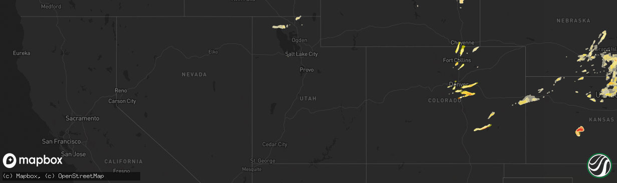
Hail
0
Estimated number of impacted properties by a 1.00" hail or larger0
Estimated number of impacted properties by a 1.75" hail or larger0
Estimated number of impacted properties by a 2.50" hail or largerStorm reports in Utah
Utah
| Date | Description |
|---|---|
| 06/03/20156:40 PM CDT | North salt flats sensor dpg25 |
| 06/02/20159:50 PM CDT | Trees down |
| 06/02/20159:45 PM CDT | Downed tree branches...irrigation system blown on to the side of the road and roll-over on interstate 15 from thunderstorm winds. |
| 06/02/20159:40 PM CDT | I-15 at plymouth |
| 06/02/20159:30 PM CDT | Mountain view at dannon way - 4910 ft |
| 06/02/20159:30 PM CDT | Baccus highway - 5172 ft |
| 06/02/20159:25 PM CDT | Trans-jordan landfill - 5201 ft |
| 06/02/20159:25 PM CDT | Large tree down on vehicle |
| 06/02/20159:20 PM CDT | Legacy parkway - 4215 ft |
| 06/02/20159:20 PM CDT | I-15 at tremonton - 4295 ft |
| 06/02/20159:15 PM CDT | Promontory point - 6926 ft |
| 06/02/20159:05 PM CDT | Promontory point - 6926 ft |
| 06/02/20158:50 PM CDT | A local report indicates 60 MPH wind near PROMONTORY |
| 06/02/20158:50 PM CDT | A local report indicates 1.50 inch wind near PROMONTORY |
| 06/02/20158:37 PM CDT | A local report indicates 1.00 inch wind near CLARKSTON |
| 06/02/20158:20 PM CDT | Curlew junction sensor utcur |
| 06/02/20158:10 PM CDT | Curlew junction sensor utcur |
| 06/02/20158:00 PM CDT | Center tailings sensor kcc13 |
All States Impacted by Hail Map on June 3, 2015
Cities Impacted by Hail Map on June 3, 2015
- Lumber City, GA
- Uvalda, GA
- Hazlehurst, GA
- Hiawatha, KS
- Troy, KS
- Everest, KS
- Robinson, KS
- Denton, KS
- Aurora, CO
- Watkins, CO
- Bennett, CO
- Byers, CO
- Strasburg, CO
- Downs, KS
- Osborne, KS
- Dry Branch, GA
- Macon, GA
- Scotia, NE
- Wolbach, NE
- Rockville, NE
- Greeley, NE
- Ashton, NE
- Farwell, NE
- Boelus, NE
- Elba, NE
- Lexington, GA
- Carlton, GA
- Midwest, WY
- Waldo, KS
- Luray, KS
- West Union, SC
- Walhalla, SC
- Pawnee City, NE
- Steinauer, NE
- Burchard, NE
- Hamilton, MO
- Jeffrey City, WY
- Hortense, GA
- Screven, GA
- Jesup, GA
- Lusk, WY
- Manville, WY
- Lawrence, NE
- Tifton, GA
- Jetmore, KS
- Ness City, KS
- Larned, KS
- Spearville, KS
- Burdett, KS
- Hanston, KS
- Nelson, NE
- Hardy, NE
- Ruskin, NE
- Superior, NE
- Mankato, KS
- Edgar, NE
- Sundance, WY
- Decker, MT
- Lodge Grass, MT
- Milford, NE
- Bristol, GA
- Odum, GA
- McCormick, SC
- Clarkesville, GA
- Sautee Nacoochee, GA
- Oelrichs, SD
- Hot Springs, SD
- Smithwick, SD
- Edgemont, SD
- Glenrock, WY
- Tellico Plains, TN
- Seneca, SC
- Salem, SC
- Augusta, GA
- Grovetown, GA
- Kaycee, WY
- Edson, KS
- Goodland, KS
- Barnesville, GA
- Grand Island, NE
- Gillette, WY
- Riverdale, NE
- Pleasanton, NE
- Burlington, CO
- Weskan, KS
- Kanorado, KS
- Plattsburg, MO
- Glen Elder, KS
- Tipton, KS
- Kiowa, CO
- Elizabeth, CO
- Franktown, CO
- Castle Rock, CO
- Parker, CO
- Long Island, KS
- Prairie View, KS
- Almena, KS
- Oberlin, KS
- Canon, GA
- Royston, GA
- Bowersville, GA
- Grafton, NE
- Sutton, NE
- Fairmont, NE
- Lincoln, NE
- Crete, NE
- Denton, NE
- Dorchester, NE
- Pleasant Dale, NE
- Morrison, CO
- Littleton, CO
- De Witt, NE
- Clatonia, NE
- Wilber, NE
- Western, NE
- Cortland, NE
- Plainville, KS
- Stockton, KS
- Jamestown, KS
- Jewell, KS
- Onaga, KS
- Wellington, CO
- Casper, WY
- Kearney, NE
- Axtell, NE
- Montrose, GA
- Danville, GA
- Havensville, KS
- Westmoreland, KS
- Frankfort, KS
- Moreland, GA
- Newnan, GA
- Plum Branch, SC
- Stephens, GA
- Palmetto, GA
- Clay Center, NE
- Bertrand, NE
- Porcupine, SD
- Wanblee, SD
- Kyle, SD
- Arlington, GA
- Hiawassee, GA
- Hayesville, NC
- Vermillion, KS
- Evergreen, CO
- Golden, CO
- Trenton, UT
- Clarkston, UT
- Cornish, UT
- Plymouth, UT
- Hallam, NE
- Glendo, WY
- Powhattan, KS
- Fairview, KS
- Larkspur, CO
- Colman, SD
- Flandreau, SD
- Jeffersonville, GA
- Fairbury, NE
- Daykin, NE
- Alexandria, NE
- Carleton, NE
- Jansen, NE
- Hebron, NE
- Belvidere, NE
- Hubbell, NE
- Davenport, NE
- Gilead, NE
- Reynolds, NE
- Bruning, NE
- Tobias, NE
- Plymouth, NE
- Esbon, KS
- Burr Oak, KS
- Valdosta, GA
- Green, KS
- Randolph, KS
- Rebecca, GA
- Westminster, SC
- Cheyenne, WY
- Lathrop, MO
- Greensboro, GA
- Eatonton, GA
- Buckhead, GA
- Keysville, GA
- Karval, CO
- Sugar City, CO
- Minden, NE
- Enigma, GA
- Alapaha, GA
- Grover, CO
- Hastings, NE
- Big Timber, MT
- Corinne, UT
- Snowville, UT
- Kidder, MO
- Cameron, MO
- Harrison, NE
- Roseland, NE
- Bladen, NE
- Loomis, NE
- Holt, MO
- Kearney, MO
- Lawson, MO
- Table Rock, NE
- Doniphan, NE
- Arapahoe, CO
- Sharon Springs, KS
- Lexington, NE
- Smithfield, NE
- Elwood, NE
- Overton, NE
- Elm Creek, NE
- Holton, KS
- Townville, SC
- Anderson, SC
- Odessa, NE
- Wood River, NE
- Dubois, WY
- Centralia, KS
- Moorcroft, WY
- Bogue, KS
- Hill City, KS
- Hugo, CO
- Shickley, NE
- Inland, NE
- Saronville, NE
- Milligan, NE
- Ong, NE
- Deweese, NE
- Harvard, NE
- Fairfield, NE
- Jackson, GA
- Portis, KS
- Carr, CO
- Nunn, CO
- Horton, KS
- Winston, MO
- Maysville, MO
- Weatherby, MO
- Osborn, MO
- Smithville, GA
- Turney, MO
- Trimble, MO
- Hephzibah, GA
- Blythe, GA
- Register, GA
- Statesboro, GA
- Amherst, NE
- Ault, CO
- Randall, KS
- Arvada, CO
- Wheat Ridge, CO
- Mayetta, KS
- Hoyt, KS
- Delia, KS
- Beatrice, NE
- Lenox, GA
- Six Mile, SC
- Central, SC
- Louviers, CO
- Sedalia, CO
- Lone Tree, CO
- Camden, MO
- Richmond, MO
- Beloit, KS
- Americus, GA
- Plains, GA
- Matthews, GA
- Wrens, GA
- Nashville, GA
- Munden, KS
- Olney Springs, CO
- Shawnee, WY
- Lance Creek, WY
- Aurora, KS
- Braymer, MO
- Norborne, MO
- Cowgill, MO
- Polo, MO
- Buffalo, WY
- Locust Grove, GA
- Milner, GA
- Jenkinsburg, GA
- Cleveland, GA
- Netawaka, KS
- Whiting, KS
- Oxford, NE
- Northboro, IA
- Riverton, NE
- Olsburg, KS
- Hodges, SC
- Guide Rock, NE
- Grantsville, UT
- White Cloud, KS
- Murphy, NC
- Colby, KS
- Loveland, CO
- Cawker City, KS
- Providence, UT
- Logan, UT
- Alma, NE
- Orleans, NE
- Agate, CO
- Iva, SC
- Calhoun Falls, SC
- Abbeville, SC
- Falls City, NE
- Morrill, KS
- Salem, NE
- Milliken, CO
- Greeley, CO
- Saint Joseph, MO
- Tremonton, UT
- Ordway, CO
- Forsyth, GA
- Sterling, NE
- Evans, CO
- Platteville, CO
- Johnstown, CO
- Mead, CO
- Lakeland, GA
- Pine Ridge, SD
- Franklin, NC
- Edgerton, MO
- Juniata, NE
- Blue Hill, NE
- Glenvil, NE
- Strang, NE
- Trumbull, NE
- Kenesaw, NE
- Ohiowa, NE
- Lost Springs, WY
- Geneva, NE
- Swanton, NE
- McCool Junction, NE
- Friend, NE
- Ayr, NE
- Henderson, NE
- Douglas, WY
- Oral, SD
- Stewartsville, MO
- Amity, MO
- Pavillion, WY
- Bendena, KS
- Atchison, KS
- Chula, GA
- Savannah, GA
- Richmond Hill, GA
- Wilcox, NE
- Dublin, GA
- Palmyra, NE
- Busby, MT
- Whitesburg, GA
- Swainsboro, GA
- Clarks, NE
- Levant, KS
- Timnath, CO
- Fort Collins, CO
- Waynesville, GA
- Waverly, GA
- White Oak, GA
- Rabun Gap, GA
- Otto, NC
- Boone, CO
- Fowler, CO
- Sabetha, KS
- Deshler, NE
- Soldier, KS
- Goff, KS
- Edgefield, SC
- Modoc, SC
- Clarks Hill, SC
- Troy, SC
- Bradley, SC
- Ninety Six, SC
- Litchfield, NE
- Formoso, KS
- Webber, KS
- Bloomington, NE
- Mauk, GA
- Rupert, GA
- Hardin, MO
- Holstein, NE
- Lincolnton, GA
- Worland, WY
- Thermopolis, WY
- Preston, ID
- Natoma, KS
- Starr, SC
- East Dublin, GA
- Wyola, MT
- Leonardville, KS
- Coolidge, GA
- Lucas, KS
- Seneca, KS
- Manderson, SD
- Sheridan, WY
- Clayton, GA
- Pattonsburg, MO
- Copperhill, TN
- Brooklet, GA
- Schuyler, NE
- Thomaston, GA
- Knoxville, GA
- Fort Valley, GA
- Lizella, GA
- Adrian, GA
- Helen, GA
- Breckenridge, MO
- Buena Vista, GA
- Crowheart, WY
- Bonaire, GA
- Belleville, KS
- Concordia, KS
- Funk, NE
- Hazard, NE
- Ravenna, NE
- Holdrege, NE
- Loup City, NE
- Reed Point, MT
- Surrency, GA
- Statenville, GA
- Fargo, GA
- Two Dot, MT
- Red Cloud, NE
- Chester, NE
- Filley, NE
- Exeter, NE
- Giltner, NE
- Oak, NE
- Aurora, NE
- Endicott, NE
- Pickrell, NE
- Clarinda, IA
- Lewiston, UT
- Shelton, NE
- Adams, NE
- Senoia, GA
- Sharpsburg, GA
- Rayville, MO
- King City, MO
- Omega, GA
- Alcova, WY
- Bozeman, MT
- Phillipsburg, KS
- Humboldt, NE
- Dawson, NE
- Gibbon, NE
- Excelsior Springs, MO
- Hanna, WY
- Blue Ridge, GA
- Epworth, GA
- Conifer, CO
- Buffalo Creek, CO
- Fort Stewart, GA
- Dover, MO
- Waverly, MO
- Folkston, GA
- Nahunta, GA
- Greenwood, SC
- Wetmore, KS
- Kinsley, KS
- Corning, KS
- Du Pont, GA
- Malcolm, NE
- Ellaville, GA
- Damascus, GA
- Colquitt, GA
- Lake Park, GA
- Demorest, GA
- Tecumseh, NE
- Crab Orchard, NE
- Hartville, WY
- Farnam, NE
- Leesburg, GA
- Courtland, KS
- Seward, NE
- Norway, KS
- Scandia, KS
- Hickman, NE
- Firth, NE
- Martell, NE
- Mahaska, KS
- Elmwood, NE
- New London, MN
- Westboro, MO
- Rock Port, MO
- Odessa, MO
- Luthersville, GA
- Elk Creek, NE
- Republican City, NE
- Stockton, GA
- Naylor, GA
- Beaver City, NE
- Tyrone, GA
- McRae Helena, GA
- Lavonia, GA
- Jennings, FL
- Pansey, AL
- Cordele, GA
- Garryowen, MT
- Gordon, GA
- Irwinton, GA
- Ocilla, GA
- Bethany, MO
- Wiggins, CO
- Bethune, CO
- Verdon, NE
- Reliance, TN
- Narka, KS
- Elberton, GA
- Ten Sleep, WY
- Princeton, KS
- Talmage, NE
- Nebraska City, NE
- Sauk Rapids, MN
- Sweetwater, TN
- Ely, NV
- Montevideo, MN
- Topeka, KS
- Emmett, KS
- Wamego, KS
- Ashburn, GA
- Beaver Crossing, NE
- Donalds, SC
- Coin, IA
- Douglasville, GA
- Atwood, KS
- Denver, CO
- Meigs, GA
- Sale City, GA
- Hartsfield, GA
- Guernsey, WY
- Wellington, MO
- David City, NE
- Alda, NE
- Wathena, KS
- Amazonia, MO
- Berthoud, CO
- Norton, KS
- Blue Rapids, KS
- Waterville, KS
- Cornelia, GA
- Union Point, GA
- Pine, CO
- Orrick, MO
- Marble, NC
- Franklin, NE
- Harrison, MT
- Moultrie, GA
- Nunda, SD
- Rutland, SD
- Ludowici, GA
- Kit Carson, CO
- Cochran, GA
- Gower, MO
- Easton, MO
- Clarksdale, MO
- Cosby, MO
- Valley Falls, KS
- Miller, NE
- Englewood, CO
- Ramah, CO
- Shoshoni, WY


