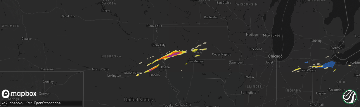
Hail Map on April 15, 2026
The weather event on April 15, 2026 includes Hail, Wind, and Tornado maps. 17 states and 1,134 cities were impacted and suffered possible damage. The total estimated number of properties impacted is 389,582.
Hail
Wind
Tornado
389,582
Estimated number of impacted properties by a 1.00" hail or larger157,218
Estimated number of impacted properties by a 1.75" hail or larger14,826
Estimated number of impacted properties by a 2.50" hail or largerStates Impacted by Hail Map on April 15, 2026
Storm reports
Nebraska
| Date | Description |
|---|---|
| 04/15/20262:05 PM CDT | A local report indicates 1.00 inch wind near 2 NNE Wahoo |
| 04/15/20261:40 PM CDT | A local report indicates 1.00 inch wind near 4 NNW Valparaiso |
| 04/15/20261:26 PM CDT | Lots of quarter to golf ball sized hail. Damage to vinyl siding. |
| 04/15/20261:26 PM CDT | Trained spotter shared hail size images on social media. |
| 04/15/20261:26 PM CDT | Delayed report from emergency management of hail up to ping pong ball sized with wind-driven damage to windows and siding. |
| 04/15/20261:22 PM CDT | A local report indicates 2.00 inch wind near 2 SSW Dwight |
| 04/15/20261:17 PM CDT | A local report indicates 1.00 inch wind near 3 ESE Ulysses |
| 04/15/202612:35 PM CDT | Mostly 1/2 to 3/4 inch hail with a few up to 1.5 inches. Ground was almost white for a few minutes but rapidly melted. |
| 04/15/202612:10 PM CDT | Picture from facebook. Time estimated from radar. |
| 04/15/202610:55 AM CDT | A local report indicates 1.00 inch wind near 3 NNW Herman |
| 04/15/202610:34 AM CDT | A local report indicates 1.00 inch wind near 1 N Winslow |
| 04/15/202610:10 AM CDT | A local report indicates 1.00 inch wind near Rogers |
| 04/15/202610:04 AM CDT | A local report indicates 1.00 inch wind near 2 E Schuyler |
| 04/15/202610:02 AM CDT | A local report indicates 1.00 inch wind near 2 S Schuyler |
| 04/15/202610:01 AM CDT | A local report indicates 1.00 inch wind near 1 ESE Schuyler |
Kansas
| Date | Description |
|---|---|
| 04/15/20266:15 PM CDT | Quarter size hail. |
| 04/15/20265:45 PM CDT | Estimated quarter sized hail from spotter... Time estimated by radar. |
| 04/15/20265:43 PM CDT | Report from mping: quarter |
| 04/15/20265:41 PM CDT | Mping report. |
| 04/15/20265:34 PM CDT | Report relayed via social media. Time estimated from radar. |
| 04/15/20265:20 PM CDT | Report from mping: quarter |
| 04/15/20265:11 PM CDT | Report from mping: quarter |
| 04/15/20264:50 PM CDT | Social media report. Time estimated from radar. |
| 04/15/20264:50 PM CDT | Report relayed via social media. Time estimated from radar. |
| 04/15/20264:47 PM CDT | Social media report. Time estimated from radar. |
| 04/15/20264:47 PM CDT | Hail lasted about ten minutes. Time estimated from radar. |
| 04/15/20264:45 PM CDT | Powerlines down. |
| 04/15/20264:44 PM CDT | Golf ball size hail at the paola golf club. Time estimated from radar. |
| 04/15/20264:41 PM CDT | Time estimated from radar. |
| 04/15/20264:41 PM CDT | Social media report. Time estimated from radar. |
| 04/15/20264:40 PM CDT | Downed wires near west street. Time estimated from radar. |
| 04/15/20264:40 PM CDT | Time estimated from radar. |
| 04/15/20264:40 PM CDT | Pws measured wind gust... Time estimated from radar. |
| 04/15/20264:40 PM CDT | Measured 2.5 inch hail in downtown paola. Time estimated from radar. |
| 04/15/20264:39 PM CDT | A local report indicates 3.00 inch wind near 1 SE Paola |
| 04/15/20264:38 PM CDT | Social media report. Time estimated from radar. |
| 04/15/20264:38 PM CDT | Social media report. Time estimated from radar. |
| 04/15/20264:38 PM CDT | Social media report. Time estimated from radar. |
| 04/15/20264:37 PM CDT | Photo from social media shows hail approximately baseball sized. Time estimated from radar. |
| 04/15/20264:36 PM CDT | Trees and powerlines down as well as considerable hail damage. |
| 04/15/20264:35 PM CDT | Tree down... Road closed due to storm damage. |
| 04/15/20264:35 PM CDT | Report of ping pong sized hail. Time estimated from radar. |
| 04/15/20264:35 PM CDT | Social media report. Damaged roof of a house. Time estimated from radar. |
| 04/15/20264:32 PM CDT | Several social media photos and videos of hail up to tennis ball size in osawatomie. Multiple homes and vehicles were damaged... With many windows and windshields crack |
| 04/15/20264:31 PM CDT | Ping pong size hail... 40mph wind gust... Torrential rainfall. |
| 04/15/20264:31 PM CDT | Quarter size hail. |
| 04/15/20264:22 PM CDT | Also report of 60mph winds. |
| 04/15/20264:15 PM CDT | A local report indicates 1.25 inch wind near Walnut |
| 04/15/20264:11 PM CDT | A local report indicates 1.00 inch wind near Chetopa |
| 04/15/20264:07 PM CDT | A local report indicates 62 MPH wind near Pleasanton |
| 04/15/20264:06 PM CDT | Numerous broken windows in town. |
| 04/15/20264:01 PM CDT | Downed wires near 400th road. Time estimated from radar. |
| 04/15/20263:56 PM CDT | Mping report. |
| 04/15/20263:49 PM CDT | A local report indicates 1.25 inch wind near 1 W Coffeyville |
| 04/15/20263:21 PM CDT | Hospital em reported golf ball sized hail at 160th and marshall in shaw. |
| 04/15/20262:57 PM CDT | Semi was blown over on us 400 just east of us 169. |
| 04/15/20262:51 PM CDT | A local report indicates 1.75 inch wind near Cherryvale |
| 04/15/20262:48 PM CDT | Location estimated. |
| 04/15/20262:48 PM CDT | Location estimated. |
| 04/14/20268:02 PM CDT | Mostly dimes with a few quarters and torrential rainfall. |
Connecticut
| Date | Description |
|---|---|
| 04/14/202611:15 PM CDT | Tree down at intersection of day hill rd and old iron ore rd in windsor. Relayed by amateur radio. |
| 04/14/202610:44 PM CDT | Tree down blocking roadway on torringford west street. |
Iowa
| Date | Description |
|---|---|
| 04/15/20266:55 PM CDT | Delayed report. |
| 04/15/20265:47 PM CDT | Report from mping: hen egg |
| 04/15/20265:45 PM CDT | Picture of 2 inch diameter hail shared by broadcast media. |
| 04/15/20265:44 PM CDT | Report from mping: golf ball |
| 04/15/20265:43 PM CDT | Largest stones were quarter sized. |
| 04/15/20265:43 PM CDT | Trained spotter reports hail of varying size... With the largest stones golf ball size. |
| 04/15/20265:42 PM CDT | Quarter-sized hail on nw side of chariton. |
| 04/15/20265:41 PM CDT | Report from mping: ping pong ball |
| 04/15/20265:38 PM CDT | Largest hail was quarter sized. |
| 04/15/20265:31 PM CDT | A local report indicates 1.00 inch wind near 3 S Vinton |
| 04/15/20264:40 PM CDT | A local report indicates 2.00 inch wind near 3 W Toledo |
| 04/15/20264:39 PM CDT | A local report indicates 2.50 inch wind near 3 W Toledo |
| 04/15/20264:39 PM CDT | Reported by trained spotter. |
| 04/15/20264:38 PM CDT | Ping pong to golf ball. |
| 04/15/20264:35 PM CDT | A local report indicates 1.00 inch wind near Winterset |
| 04/15/20264:35 PM CDT | Picture on social media of a measured half dollar size hail stone. |
| 04/15/20264:35 PM CDT | Delayed report. Time estimated by radar. |
| 04/15/20264:31 PM CDT | A local report indicates 1.00 inch wind near Le Grand |
| 04/15/20264:28 PM CDT | Nickel to quarter sized hail in la porte city. |
| 04/15/20264:23 PM CDT | A local report indicates 1.00 inch wind near 2 N Buck Grove |
| 04/15/20264:15 PM CDT | Report from mping: quarter |
| 04/15/20264:15 PM CDT | Trained spotter sent a picture of a hail stone 1 inch in diameter. |
| 04/15/20263:48 PM CDT | A local report indicates 1.00 inch wind near Collins |
| 04/15/20262:14 PM CDT | Report of damage so far is a barn lost a lean-to and part of a roof. Time estimated from radar. |
| 04/15/20262:04 PM CDT | A local report indicates 1.25 inch wind near Story City |
| 04/15/20262:00 PM CDT | A local report indicates 1.00 inch wind near 1 W Story City |
| 04/15/202612:49 PM CDT | Time estimated from radar. |
| 04/15/202612:33 PM CDT | A local report indicates 1.50 inch wind near Glidden |
| 04/15/202612:32 PM CDT | A local report indicates 2.50 inch wind near 3 WSW Glidden |
| 04/15/202612:12 PM CDT | A local report indicates 1.50 inch wind near 2 N Buck Grove |
| 04/15/202612:05 PM CDT | A local report indicates 1.75 inch wind near Vail |
| 04/15/202611:54 AM CDT | Between ping ball and golf ball size. |
| 04/15/202611:54 AM CDT | Social media picture of measured hail near the denison hospital. Time estimated from radar. |
| 04/15/202611:51 AM CDT | Time estimated from radar. |
| 04/15/202611:43 AM CDT | A local report indicates 1.50 inch wind near Dow City |
| 04/15/202611:35 AM CDT | All windows broken on the west side of home. |
| 04/15/202611:33 AM CDT | A local report indicates 1.75 inch wind near Dunlap |
| 04/15/202611:18 AM CDT | A local report indicates 1.00 inch wind near Pisgah |
| 04/15/202611:10 AM CDT | A local report indicates 1.50 inch wind near 4 S Pisgah |
| 04/14/20269:08 PM CDT | A local report indicates 1.00 inch wind near 2 W Colo |
| 04/14/20269:00 PM CDT | A local report indicates 1.75 inch wind near 3 SSE Nevada |
| 04/14/20268:50 PM CDT | Time estimated from radar. |
| 04/14/20268:50 PM CDT | Largest hail is golf ball size. |
| 04/14/20268:47 PM CDT | Relayed by em. |
| 04/14/20268:46 PM CDT | Time estimated from radar. |
| 04/14/20268:46 PM CDT | A few 2 inch... Mostly 1.75 and smaller. |
| 04/14/20268:36 PM CDT | Relayed from spotter network. |
| 04/14/20268:35 PM CDT | A local report indicates 1.00 inch wind near Earlham |
| 04/14/20268:29 PM CDT | A local report indicates 1.00 inch wind near Madrid |
| 04/14/20268:24 PM CDT | Relayed by em. |
| 04/14/20268:23 PM CDT | Reported by general public. |
| 04/14/20268:21 PM CDT | Nickel to half dollar size. |
| 04/14/20268:15 PM CDT | Numerous large branches downed in town. |
| 04/14/20268:05 PM CDT | Time estimated from radar. |
| 04/14/20267:58 PM CDT | Powerlines down. Time estimated using radar. Also reported a funnel cloud. |
| 04/14/20267:42 PM CDT | A local report indicates 1.00 inch wind near Riverside |
| 04/14/20267:33 PM CDT | Semi tipped over on us highway 218. |
Pennsylvania
| Date | Description |
|---|---|
| 04/15/20266:45 PM CDT | Corrects previous hail report from 1 sw franklin. |
| 04/15/20266:19 PM CDT | Pine tree snapped. |
| 04/15/20266:15 PM CDT | A few trees downed across central erie county. |
| 04/15/20266:10 PM CDT | A local report indicates 1.50 inch wind near 1 WNW Cranberry |
| 04/15/20266:10 PM CDT | Tree downed and blocking road. Time estimated via radar. |
| 04/15/20266:10 PM CDT | A local report indicates 1.00 inch wind near 3 ESE Cranberry |
| 04/15/20266:06 PM CDT | A local report indicates 1.50 inch wind near 1 S Cranberry |
| 04/15/20265:45 PM CDT | Hail size estimated from photo. |
| 04/15/20265:45 PM CDT | A few reports of trees and wires down in sandy lake township. Time estimated from radar. |
| 04/15/20265:42 PM CDT | Report from mping: quarter |
| 04/15/20265:40 PM CDT | Several reports of trees and wires down. Time estimated from radar. |
| 04/15/20265:38 PM CDT | Report from mping: quarter |
| 04/15/20265:36 PM CDT | Report from mping: half dollar |
| 04/15/20265:34 PM CDT | Report from mping: quarter |
| 04/15/20265:30 PM CDT | Public shared a picture of ping pong ball size hail on social media. Time estimated based off radar. |
| 04/15/20265:22 PM CDT | Report from 511pa of tree down on w kidds mill rd near reynolds industrial park rd. Time estimated based off radar. |
| 04/15/20265:22 PM CDT | A local report indicates 1.00 inch wind near Greenville |
| 04/15/20265:22 PM CDT | Trees down. |
| 04/15/20265:15 PM CDT | Several reports of trees and wires down in west salem township. Time estimated from radar. |
| 04/15/20265:14 PM CDT | A local report indicates 1.25 inch wind near 3 W Greenville |
| 04/15/20265:14 PM CDT | A local report indicates 1.75 inch wind near 2 NE Orangeville |
| 04/15/20265:12 PM CDT | Trees and wires down near coryville. |
| 04/15/20264:51 PM CDT | Trees and wires down near custer city. |
| 04/15/20264:48 PM CDT | Trees and wires down near lewis run. |
| 04/14/202611:21 PM CDT | Wires down on springbrook road. |
| 04/14/202610:54 PM CDT | I-380 penndot exit 20 keystone mesonet maximum gust was 67 mph. |
| 04/14/202610:54 PM CDT | Tree down on roadway in moscow. |
| 04/14/202610:50 PM CDT | Corrects timing previous tstm wnd gst report from 1 nw fells corners. I-380 penndot exit 20 keystone mesonet maximum gust was 67 mph. |
| 04/14/202610:50 PM CDT | Padot station 11339 1 nw fells corners. |
| 04/14/202610:33 PM CDT | Tree down on main st. |
| 04/14/202610:30 PM CDT | Photos sent to nws with several uprooted softwood trees in backyard... North abingdon township. Radar-estimated time. |
| 04/14/202610:15 PM CDT | Multiple trees uprooted and snapped on private property. |
| 04/14/202610:06 PM CDT | Tree down on 1800 block of pa 42. |
| 04/14/20269:58 PM CDT | Tree down on roadway. |
| 04/14/20269:55 PM CDT | Tree down on dunwoody rd. |
| 04/14/20269:39 PM CDT | Roof off a house on 5900 block warrensville rd. |
| 04/14/20269:36 PM CDT | Large tree down blocking the roadway at beech valley rd and calvert rd. |
| 04/14/20268:12 PM CDT | Wires down on cars on redwood avenue. |
| 04/14/20267:56 PM CDT | Trees down on wires along beechwood road. |
| 04/14/20267:40 PM CDT | Tree down on wire... Which caught fire. Bradley road. Also at least pea-sized hail in the athens-milan area. Radar-estimated time. |
| 04/14/20267:12 PM CDT | Wires down on coryland road near church. Radar-estimated time. |
Illinois
| Date | Description |
|---|---|
| 04/15/20266:50 PM CDT | A local report indicates 1.00 inch wind near Nora |
| 04/14/20269:44 PM CDT | Trees reported down blocking roadway. Keslinger and harley roads. Vehicle then struck downed tree. No injuries reported. |
| 04/14/20269:40 PM CDT | Relayed by em. Power lines and possibly power poles down along dauberman road. |
| 04/14/20269:38 PM CDT | Semi overturned on i-88 westbound. Westbound shut down at dauberman road. |
| 04/14/20269:26 PM CDT | Review of drone imagery provided by adams county ema showed damage consistent with a tornado of ef1 strength that tracked briefly along of highway 61. |
| 04/14/20268:45 PM CDT | Relayed by broadcast media. |
| 04/14/20268:30 PM CDT | Tree downed. |
| 04/14/20268:27 PM CDT | Reported at wifr. |
| 04/14/20268:20 PM CDT | Medium to large tree branches downed. Time estimated from radar. |
| 04/14/20268:20 PM CDT | A local report indicates 1.00 inch wind near Winnebago |
| 04/14/20268:19 PM CDT | Small portion of metal roof paneling peeled off of farm outbuilding. Time estimated from radar. |
| 04/14/20268:16 PM CDT | Updates previous tstm wnd dmg report from 2 se seward. Several tree branches downed along murphy road west of conger road. Time estimated from radar. |
| 04/14/20268:15 PM CDT | Two power poles downed along pecatonica road just north of kelley road. Time estimated from radar. |
| 04/14/20268:14 PM CDT | Possible tornado. Numerous trees damaged along murphy road... West of s conger road. |
| 04/14/20268:12 PM CDT | Tree uprooted and possible door or siding damage to farm outbuilding. Time estimated from radar. |
Wisconsin
| Date | Description |
|---|---|
| 04/14/20268:34 PM CDT | A local report indicates 1.00 inch wind near 2 SE Elkhorn |
| 04/14/20268:32 PM CDT | Mping report out of hales corners. Time estimated from radar. |
| 04/14/20268:01 PM CDT | Ef1 tornado west of elkhorn. Metal roof and wall panels ripped off buildings and lofted. Tree damage. Maximum estimated wind speed of 100 mph. Path of approximately 2 m |
New York
| Date | Description |
|---|---|
| 04/15/20266:50 PM CDT | Several reports of trees and wires downed in new albion. |
| 04/15/20266:48 PM CDT | Tree down on house on caroline drive. Radar-estimated time. |
| 04/15/20266:48 PM CDT | Tree on house through roof along lindley road as per county dispatch feed. Radar-estimated time. |
| 04/15/20266:47 PM CDT | Several reports of trees and wires downed in cattaraugus. |
| 04/15/20266:46 PM CDT | Nws storm survey found damage consistent with a 90-100 mph microburst... Most significantly numerous snapped trees down a hillside along morgan creek road with addition |
| 04/15/20266:41 PM CDT | Trees and wires downed in leon. |
| 04/15/20266:38 PM CDT | County route 100 with tree down blocking road as per county dispatch feed. Radar-estimated time. |
| 04/15/20266:38 PM CDT | Reports of several trees... Power lines and power poles downed across cherry creek. |
| 04/15/20266:36 PM CDT | County route 81 blocked by tree as per dispatch feed. Radar-estimated time. |
| 04/15/20266:20 PM CDT | Updates previous tstm wnd dmg report from 4 sse hornby. Tree and wires down on mormon hollow road as per county dispatch feed. Also 3 power poles down. Radar-estimated |
| 04/15/20266:20 PM CDT | Tree and wires down on mormon hollow road as per county dispatch feed. Radar-estimated time. |
| 04/14/202610:14 PM CDT | Tree hanging on power lines at 18 main street in hyde park. |
| 04/14/202610:11 PM CDT | Tree blocking lane at 5862 elm avenue in the village of millerton. |
| 04/14/202610:07 PM CDT | Tree across route 32 in rosendale. |
| 04/14/202610:06 PM CDT | Tree down on route 82 and strever farm road. |
| 04/14/202610:00 PM CDT | Tree down on residence on atwood road in stone ridge. |
| 04/14/20269:53 PM CDT | Tree down blocking road at intersection of hapeman hill road and turkey hill road. |
| 04/14/20269:50 PM CDT | Tree and wires down on liden avenue in red hook. |
| 04/14/20269:43 PM CDT | Tree down on route 28a in the town of catskill. |
| 04/14/20269:39 PM CDT | Delayed social media report of a tree down on wires near lighthouse dr in saugerties. Time estimated from radar. |
| 04/14/20268:57 PM CDT | Tree down on road near old 17 & cashmere road. |
| 04/14/20268:39 PM CDT | Wires down. |
| 04/14/20268:00 PM CDT | Radar-estimated time. A couple trees down at bridge street and chapel street intersection... And east windsor road. As per dispatch feed. |
| 04/14/20267:58 PM CDT | Quarter mile swath of tree and powerline damage on water wells road in alfred. Time estimated based on radar. |
| 04/14/20267:14 PM CDT | Several trees uprooted in multiple directions shortly after the intersection of tug hill road and gulf hill road. Primary residence had a window blown in the upper most |
| 04/14/20267:09 PM CDT | Several reports of trees and wires downed in machias. |
| 04/14/20267:07 PM CDT | Several reports of trees and wires downed in delevan. |
Arkansas
| Date | Description |
|---|---|
| 04/14/202611:14 PM CDT | Home weather station measured 62mph gust. |
| 04/14/202611:03 PM CDT | Tree on house. |
| 04/14/202610:44 PM CDT | Corrects previous tstm wnd dmg report from 1 sse clarksville. Tree on house. Time based on radar. |
| 04/14/202610:37 PM CDT | Tree fell onto a storm shelter. |
| 04/14/202610:27 PM CDT | Multiple trees down in coal hill and hartman areas. |
| 04/14/20269:50 PM CDT | Tree down near highway 22 and plantation lane. Time estimated from radar. |
| 04/14/20269:25 PM CDT | Tree down near bear hollow road and bear hollow heights. Time estimated from radar. |
| 04/14/20269:20 PM CDT | Tree blocking southbound lane at highway 45 and mt. Zion road. Time estimated by radar. |
| 04/14/20269:20 PM CDT | Tree down blocking bear hollow road near highway 45. |
Oklahoma
| Date | Description |
|---|---|
| 04/15/20266:48 PM CDT | Report from mping: quarter |
| 04/15/20266:44 PM CDT | A local report indicates 1.00 inch wind near Ardmore |
| 04/15/20266:27 PM CDT | A local report indicates 1.25 inch wind near 4 S Stillwater |
| 04/15/20266:10 PM CDT | X post with picture. |
| 04/15/20264:34 PM CDT | Sporadic two inch hail stones. |
| 04/15/20264:34 PM CDT | Report from mping: ping pong ball |
| 04/15/20264:32 PM CDT | Hail starting to cover the ground. Relayed by ham radio. |
| 04/15/20264:32 PM CDT | A local report indicates 1.75 inch wind near 1 SSE Bartlesville |
| 04/15/20263:56 PM CDT | A local report indicates 1.00 inch wind near Pawhuska |
| 04/15/20262:25 PM CDT | Photo shared on social media. |
| 04/15/20262:18 PM CDT | Report from mping: quarter |
| 04/15/20268:56 AM CDT | Report from mping: quarter |
| 04/14/202611:23 PM CDT | A local report indicates 63 MPH wind near 1 S Watova |
| 04/14/20269:25 PM CDT | Near us highway 60 and ok highway 156. |
| 04/14/20268:14 PM CDT | Nwschat report of a few trees down through atoka. |
| 04/14/20268:00 PM CDT | Downed tree blocking eastbound traffic on highway 10. |
| 04/14/20267:04 PM CDT | Picture of large tree branches down on side of bridge. |
Texas
| Date | Description |
|---|---|
| 04/15/20266:57 PM CDT | Facebook video showed hail up to half dollar size and estimated 50-60 mph winds near the hwy 199/281 split southeast of jacksboro. |
| 04/15/20266:50 PM CDT | A local report indicates 1.75 inch wind near Miles |
| 04/15/20266:35 PM CDT | From spotter network. |
| 04/15/20266:30 PM CDT | A local report indicates 1.75 inch wind near Harriet |
| 04/15/20266:27 PM CDT | Video on x showed hail up to quarter size at hwy 16 and fm 1191. |
| 04/15/20266:27 PM CDT | Viewer sent broadcast media a picture of quarter to half dollar sized hail on south miller street near downtown breckenridge. |
| 04/15/20266:24 PM CDT | Report from mping half dollar 1.25 in. |
| 04/15/20266:22 PM CDT | Several facebook reports and photos of up to golfball size hail in breckenridge. |
| 04/15/20265:42 PM CDT | Krph. Time estimated from radar. |
| 04/15/20265:30 PM CDT | A local report indicates 1.00 inch wind near 4 SW Graham |
| 04/15/20265:27 PM CDT | Photos on x showed ping pong ball size hail on the south side of graham along hwy 16. |
| 04/15/20265:20 PM CDT | Golf ball sized hail reported by hraham pd at hwy 67 near medlan chapen rd. |
| 04/15/20265:01 PM CDT | Reported golfball size hail along county line southeast of woodson by woodson vfd. |
| 04/15/20264:56 PM CDT | 65 mph winds from a storm southeast of woodson along county line. Reported by woodson vfd. |
| 04/15/20264:29 PM CDT | Report from mping: quarter |
| 04/15/20264:25 PM CDT | Additional reports of quarter sized hail and 3 inch tree limbs down at 1954 and pocahontas. |
| 04/15/20263:42 PM CDT | Wichita county skywarn reports quarters in downtown wichita falls. |
| 04/14/20269:54 PM CDT | Time estimated via radar. |
| 04/14/20269:27 PM CDT | Report from mping. |
| 04/14/20269:24 PM CDT | Facebook photo showed a tree down on north travis street near us 75. |
| 04/14/20267:51 PM CDT | Tree down on fm730 along with hail up to nickel size. |
| 04/14/20267:15 PM CDT | Report and video on x showed up to quarter size hail fell in runaway bay. |
| 04/14/20267:04 PM CDT | Time estimated via radar. |
| 04/14/20267:00 PM CDT | A local report indicates 1.00 inch wind near 7 SE Jacksboro |
Ohio
| Date | Description |
|---|---|
| 04/15/20266:26 PM CDT | Trees downed in and around hubbard. |
| 04/15/20266:25 PM CDT | Trees downed in brookfield. |
| 04/15/20266:25 PM CDT | Tree downed. Time estimated via radar. |
| 04/15/20266:05 PM CDT | Quarter sized hail reported by the public. |
| 04/15/20266:04 PM CDT | A couple of trees downed in milton twp near the trumbull co line. |
| 04/15/20265:57 PM CDT | Several trees downed in suffield township. |
| 04/15/20265:48 PM CDT | Social media images of large hail and damaged vehicles. |
| 04/15/20265:46 PM CDT | A few trees downed in sawyerwood/springfield twp. |
| 04/15/20265:45 PM CDT | Two downed trees in hiram. |
| 04/15/20265:40 PM CDT | Images shared via social media of large hail. |
| 04/15/20265:30 PM CDT | Mainly dime to penny-sized but some as large as quarters. |
| 04/15/20265:26 PM CDT | Straight line wind damage... Several power poles |
| 04/15/20265:16 PM CDT | Public report of significant accumulation of one inch and greater hail. |
| 04/15/20265:13 PM CDT | Report from mping: ping pong ball |
| 04/15/20265:13 PM CDT | Report from mping: ping pong ball |
| 04/15/20265:10 PM CDT | Several trees downed in hartford twp. |
| 04/15/20265:08 PM CDT | Numerous branches broken. |
| 04/15/20265:06 PM CDT | Intersection of sr 88 and phillips rice rd. |
| 04/15/20265:00 PM CDT | Tree down. |
| 04/15/20265:00 PM CDT | Significant accumulation of hail on i271 creating a slush and slowing traffic. |
| 04/15/20264:53 PM CDT | A local report indicates 1.00 inch wind near Grafton |
| 04/15/20264:48 PM CDT | Corrects previous hail report from bristolville. Social media images of large hail and damaged vehicles. |
| 04/15/20264:48 PM CDT | Significant damage from a combination of wind and hail in bristolville... Including downed trees and power polls along with damage to siding... Roofs and windows. |
| 04/15/20264:48 PM CDT | Time estimated via radar. |
| 04/15/20264:48 PM CDT | Report from mping: golf ball |
| 04/15/20264:46 PM CDT | Time estimated via radar. |
| 04/15/20264:27 PM CDT | A local report indicates 1.75 inch wind near Kipton |
| 04/15/20264:21 PM CDT | Time estimated via radar. |
| 04/15/20264:20 PM CDT | Report from mping: golf ball |
| 04/15/20264:18 PM CDT | Several trees down. Time estimated via radar. |
| 04/15/20264:16 PM CDT | Corrects previous hail report from bainbridge. Public report of significant accumulation of one inch and greater hail. |
| 04/15/20264:10 PM CDT | Significant storm damage in solon from a combination of wind and hail. Numerous trees were downed with some falling onto houses. Damage to siding and windows due to win |
| 04/15/20264:09 PM CDT | A local report indicates 1.00 inch wind near Solon |
| 04/15/20264:09 PM CDT | Delayed report. Time estimated via radar. |
| 04/15/20264:09 PM CDT | A local report indicates 1.25 inch wind near 4 WSW Republic |
| 04/15/20264:05 PM CDT | Corrects previous tstm wnd dmg report from tiffin. Straight line wind damage... Several power poles |
| 04/15/20264:03 PM CDT | A local report indicates 1.00 inch wind near 5 SSW Norwalk |
| 04/15/20264:03 PM CDT | Hail lasted 10 to 15 minutes ranging in size from 1.00 to 2.00 inches in diameter. |
| 04/15/20264:03 PM CDT | A local report indicates 1.75 inch wind near 1 SW Maple Heights |
| 04/15/20264:03 PM CDT | A local report indicates 2.00 inch wind near 1 NNE Bedford |
| 04/15/20264:02 PM CDT | Picture of hail slightly over 2 inch in diameter hail received from bedford. |
| 04/15/20264:00 PM CDT | A local report indicates 1.25 inch wind near Bedford |
| 04/15/20263:58 PM CDT | A local report indicates 1.50 inch wind near 1 NNE Seven Hills |
| 04/15/20263:55 PM CDT | Updated previous hail report from 1 n seven hills to 2 inch diameter hail. |
| 04/15/20263:55 PM CDT | A local report indicates 1.50 inch wind near 1 N Seven Hills |
| 04/15/20263:48 PM CDT | A local report indicates 1.00 inch wind near 1 ESE Parma Heights |
| 04/15/20263:47 PM CDT | A local report indicates 1.00 inch wind near 1 NE Parma |
| 04/15/20263:40 PM CDT | Corrects previous hail report from solon. Images shared via social media of large hail. |
| 04/15/20263:34 PM CDT | A local report indicates 1.00 inch wind near 3 E Tiffin |
| 04/15/20263:30 PM CDT | 70mph wind gusts. |
| 04/15/20263:26 PM CDT | Corrects previous tstm wnd dmg report from tiffin. Straight line wind damage... Several power poles |
| 04/15/20263:12 PM CDT | Tree and power-lines downed in bowling green. |
| 04/15/20263:08 PM CDT | Collapsed barn. Time estimated via radar. |
| 04/15/20263:03 PM CDT | Tree downed partially onto a moving car on oh 281 between milton road and weston road outside of custar. |
| 04/15/20263:03 PM CDT | Tree and power-lines downed. Time estimated via radar. |
| 04/15/20263:00 PM CDT | Barn collapse. |
| 04/15/20263:00 PM CDT | Barn collapse. |
| 04/15/20262:32 PM CDT | A local report indicates 1.50 inch wind near Defiance |
| 04/15/20262:05 PM CDT | A local report indicates 1.00 inch wind near Hicksville |
Missouri
| Date | Description |
|---|---|
| 04/15/20266:48 PM CDT | Public/social media report... Time estimated from radar. |
| 04/15/20266:44 PM CDT | Large limbs down... Estimated 60 mph wind gusts. Time estimated from radar. |
| 04/15/20266:23 PM CDT | Social media report. Time estimated from radar. |
| 04/15/20266:13 PM CDT | Metal roofing of building torn off. Time estimated from radar. |
| 04/15/20266:09 PM CDT | Tornado reported on the ground by storm chaser. |
| 04/15/20265:59 PM CDT | Taken from social media... Video of bent power poles and shingles blown off house. Time estimated by radar. |
| 04/15/20265:58 PM CDT | A local report indicates 1.25 inch wind near 2 S Kingston |
| 04/15/20265:47 PM CDT | Report from mping: half dollar |
| 04/15/20265:45 PM CDT | Social media report. Time confirmed from radar. |
| 04/15/20265:44 PM CDT | A local report indicates 1.25 inch wind near 2 NW Knoxville |
| 04/15/20265:41 PM CDT | Taken from social media. Time estimated by radar. |
| 04/15/20265:39 PM CDT | Large tree downed at a residence. Time estimated from radar. |
| 04/15/20265:35 PM CDT | Social media report. Time estimated from radar. |
| 04/15/20265:30 PM CDT | Social media report. Time estimated from radar. |
| 04/15/20265:29 PM CDT | Downed wires near mica lane. Time estimated from radar. |
| 04/15/20265:28 PM CDT | Damaged pole and downed wires south of excelsior springs. Time estimated from radar. |
| 04/15/20265:26 PM CDT | Report from mping: quarter |
| 04/15/20265:20 PM CDT | Report from mping: quarter |
| 04/15/20265:20 PM CDT | Half dollar sized hail reported at crowder state park. |
| 04/15/20265:19 PM CDT | Downed tree limbs and wires near highland avenue. Time estimated from radar. |
| 04/15/20265:13 PM CDT | Social media report. Time estimated from radar. |
| 04/15/20265:10 PM CDT | Time estimated from radar. |
| 04/15/20265:07 PM CDT | Downed tree limbs and wires near park avenue. Time estimated from radar. |
| 04/15/20265:07 PM CDT | Social media report. Time estimated from radar. |
| 04/15/20265:07 PM CDT | Downed wires near foxwood drive. Time estimated from radar. |
| 04/15/20265:07 PM CDT | Large tree uprooted and house and siding damage from wind-driven hail at a residence near lone jack. Time estimated from radar. |
| 04/15/20265:07 PM CDT | Downed tree limbs and wires near falk drive. Time estimated from radar. |
| 04/15/20265:06 PM CDT | Video from social media shows estimated quarter sized hail. Time taken from social media and confirmed by radar. |
| 04/15/20265:04 PM CDT | Several social media reports of hail up to golf ball size east of bethany. Time estimated from radar. |
| 04/15/20265:02 PM CDT | Social media report of quarter size hail in the strasburg area. Time estimated from radar. |
| 04/15/20265:00 PM CDT | Taken from social media... Estimated ping pongs. Time estimated from radar. |
| 04/15/20264:56 PM CDT | Social media report. Time estimated from radar. |
| 04/15/20264:53 PM CDT | Social media report. Time estimated from radar. |
| 04/15/20264:53 PM CDT | Social media report. Time estimated from radar. |
| 04/15/20264:52 PM CDT | Em passed along report of estimated 3 inch hail from deputy. Time estimated from radar. |
| 04/15/20264:50 PM CDT | Social media report. Time estimated from radar. |
| 04/15/20264:50 PM CDT | Social media report with photo of broken windshield. Time estimated from radar. |
| 04/15/20264:48 PM CDT | Photo relayed via social media. |
| 04/15/20264:47 PM CDT | Social media report. Time estimated from radar. |
| 04/15/20264:47 PM CDT | Taken from social media... Time estimated from radar. |
| 04/15/20264:47 PM CDT | *** 1 inj *** vehicular accident was caused by the hail with one injury. Time estimated from radar. |
| 04/15/20264:29 PM CDT | Social media report and photos. Time estimated from radar. |
| 04/15/20264:29 PM CDT | Social media report. Time estimated from radar. |
| 04/15/20264:26 PM CDT | Social media report. Time estimated from radar. |
| 04/15/20264:26 PM CDT | Report relayed via social media. Time estimated from radar. |
| 04/15/20264:22 PM CDT | Time estimated from radar. |
| 04/15/20264:20 PM CDT | Report from social media. Time estimated from radar. |
| 04/15/20264:19 PM CDT | Social media report and video of ping pong ball size hail northwest of cameron. Time estimated from radar. |
| 04/15/20264:17 PM CDT | A local report indicates 1.00 inch wind near 1 NW Kearney |
| 04/15/20264:13 PM CDT | Social media report and video. Time estimated from radar. |
| 04/14/20269:35 PM CDT | Tree over the roadway. |
| 04/14/20269:26 PM CDT | A local report indicates 59 MPH wind near Oronogo |
| 04/14/20269:22 PM CDT | Thunderstorm winds downed a large tree over state highway 126 west of i-49. |
| 04/14/20268:50 PM CDT | Large tree down. |
| 04/14/20268:42 PM CDT | Thunderstorm winds downed a tree into the roadway. |
| 04/14/20268:40 PM CDT | A tree fell into the roadway on y highway northwest of rolla. |
| 04/14/20268:15 PM CDT | Large downed tree blocking entire road. |
| 04/14/20267:43 PM CDT | Quarter size hail. |
| 04/14/20267:38 PM CDT | Roof damage at the building near the airport. No additional info at this time. |
| 04/14/20267:35 PM CDT | Large tree down and other large limbs down. |
| 04/14/20267:19 PM CDT | Social media report. Time estimated from radar. |
Indiana
| Date | Description |
|---|---|
| 04/15/20261:00 PM CDT | Reported at the stonehenge golf course. |
| 04/15/202612:55 PM CDT | Hail ranging from marble to half dollar size reported on the northeast side of claypool. |
| 04/15/202612:52 PM CDT | Broadcast media relayed a photo from the public of what is estimated to be between 2 and 2.25 inch hail in claypool. Delayed report and time estimated by radar. |
| 04/15/202612:34 PM CDT | Emergency management reports portions of a flat roof at elks lodge ripped off. Time estimated by radar. |
Cities Impacted by Hail Map on April 15, 2026
- Genoa, NE
- Kingston, OK
- Monroe, NE
- Saybrook, IL
- Columbus, NE
- Bellwood, NE
- Schuyler, NE
- Leigh, NE
- David City, NE
- Rogers, NE
- Clarkson, NE
- Dodge, NE
- Howells, NE
- North Bend, NE
- Ames, NE
- Hooper, NE
- Scribner, NE
- Tekamah, NE
- Craig, NE
- Herman, NE
- Winslow, NE
- Nashoba, OK
- Little Sioux, IA
- Mondamin, IA
- Arlington, NE
- Pisgah, IA
- Logan, IA
- Woodbine, IA
- Moorhead, IA
- Dunlap, IA
- Dow City, IA
- Earling, IA
- Onawa, IA
- West Point, NE
- Denison, IA
- Arion, IA
- Defiance, IA
- Charter Oak, IA
- Ute, IA
- Soldier, IA
- Manilla, IA
- Westside, IA
- Vail, IA
- Deloit, IA
- Aspinwall, IA
- Manning, IA
- Arcadia, IA
- Breda, IA
- Kiron, IA
- Halbur, IA
- Carroll, IA
- Templeton, IA
- Hampton, NE
- Aurora, NE
- Giltner, NE
- Harvard, NE
- Irwin, IA
- Glidden, IA
- Henderson, NE
- Rochester, IN
- Kewanna, IN
- Scranton, IA
- Ralston, IA
- Churdan, IA
- Jefferson, IA
- Silver Lake, IN
- Claypool, IN
- Akron, IN
- Warsaw, IN
- Pierceton, IN
- Coon Rapids, IA
- Dedham, IA
- Waco, NE
- York, NE
- Mentone, IN
- Utica, NE
- Staplehurst, NE
- Gresham, NE
- Paton, IA
- Ulysses, NE
- Seward, NE
- Dwight, NE
- Bee, NE
- Winona Lake, IN
- Bradshaw, NE
- Roann, IN
- Macy, IN
- Brainard, NE
- Valparaiso, NE
- Dana, IA
- Weston, NE
- Rome City, IN
- Kendallville, IN
- Hudson, IN
- Corunna, IN
- Wolcottville, IN
- Stratford, IA
- Stanhope, IA
- North Manchester, IN
- Liberty Mills, IN
- Churubusco, IN
- Huntertown, IN
- Fort Wayne, IN
- Ashley, IN
- Pleasant Lake, IN
- Wahoo, NE
- Malmo, NE
- Ceresco, NE
- Boone, IA
- Ames, IA
- Story City, IA
- Gilbert, IA
- Jewell, IA
- Colon, NE
- Roland, IA
- Randall, IA
- Mark Center, OH
- Sherwood, OH
- Hicksville, OH
- Antwerp, OH
- Cecil, OH
- Mead, NE
- Graham, TX
- Grabill, IN
- Edgerton, OH
- Dewey, OK
- Bartlesville, OK
- Radcliffe, IA
- Alden, IA
- Ellsworth, IA
- Olney, TX
- Newcastle, TX
- Auburn, IN
- Leo, IN
- Spencerville, IN
- Blissfield, MI
- Riga, MI
- Ottawa Lake, MI
- Ida, MI
- Petersburg, MI
- Saint Joe, IN
- Harlan, IN
- McCallsburg, IA
- Yutan, NE
- Fremont, NE
- Valley, NE
- Defiance, OH
- Barnsdall, OK
- Ochelata, OK
- Ramona, OK
- Iowa Falls, IA
- Skiatook, OK
- Wann, OK
- New Haven, IN
- Copan, OK
- Holgate, OH
- Coffeyville, KS
- Dearing, KS
- Ackley, IA
- Aplington, IA
- Hominy, OK
- Archbold, OH
- Bryan, OH
- Stryker, OH
- Ney, OH
- Evansport, OH
- Napoleon, OH
- Liberty, KS
- Hubbard, IA
- Zearing, IA
- Independence, KS
- Cherryvale, KS
- Malinta, OH
- Dennis, KS
- Parsons, KS
- Galesburg, KS
- Thayer, KS
- Union, IA
- New Providence, IA
- Nowata, OK
- Austinville, IA
- Hamler, OH
- Conrad, IA
- Erie, KS
- Beaman, IA
- Stuart, IA
- Huxley, IA
- Cambridge, IA
- Merkel, TX
- Eldora, IA
- Whitten, IA
- Liscomb, IA
- Blair, NE
- Kennard, NE
- Slater, IA
- Delaware, OK
- Leipsic, OH
- Polk City, IA
- Parkersburg, IA
- Custar, OH
- Cygnet, OH
- Rudolph, OH
- Martin, OH
- Haskins, OH
- Dunbridge, OH
- Bowling Green, OH
- Pemberville, OH
- Woodville, OH
- Stony Ridge, OH
- New Bavaria, OH
- Bradner, OH
- Liberty Center, OH
- Risingsun, OH
- Walbridge, OH
- Gibsonburg, OH
- Wayne, OH
- Portage, OH
- Helena, OH
- Weston, OH
- Luckey, OH
- McClure, OH
- Tontogany, OH
- Elmore, OH
- Grelton, OH
- Deshler, OH
- Perrysburg, OH
- Genoa, OH
- Clay Center, OH
- Millbury, OH
- Waterville, OH
- Graytown, OH
- Milton Center, OH
- Grand Rapids, OH
- Chanute, KS
- Dexter, IA
- Missouri Valley, IA
- Lenapah, OK
- Grafton, OH
- North Ridgeville, OH
- Elyria, OH
- Lagrange, OH
- Columbia Station, OH
- Saint Paul, KS
- Hoytville, OH
- North Baltimore, OH
- Walnut, KS
- Pawnee, OK
- Fairfax, OK
- McComb, OH
- Pawhuska, OK
- Modale, IA
- Magnolia, IA
- Seymour, TX
- Wichita Falls, TX
- Holliday, TX
- Maxwell, IA
- Collins, IA
- Tiffin, OH
- Bloomville, OH
- Republic, OH
- Kansas, OH
- Rocky Ridge, OH
- Lindsey, OH
- Fremont, OH
- Fostoria, OH
- Burgoon, OH
- Oak Harbor, OH
- McCutchenville, OH
- Blockton, IA
- Bedford, IA
- Hawley, TX
- Elsmore, KS
- Stark, KS
- Savonburg, KS
- Olmsted Falls, OH
- Gladbrook, IA
- Prescott, IA
- Corning, IA
- Abilene, TX
- Anson, TX
- Wynona, OK
- Independence, OH
- Cleveland, OH
- State Center, IA
- Rhodes, IA
- Maple Heights, OH
- Bedford, OH
- Lueders, TX
- S Coffeyville, OK
- Diagonal, IA
- Edna, KS
- Brookpark, OH
- Okemah, OK
- Mapleton, KS
- Albany, TX
- Berea, OH
- North Royalton, OH
- Hudson, IA
- Welch, OK
- Shannon City, IA
- Traer, IA
- Creston, IA
- Greenfield, IA
- Reinbeck, IA
- Seminole, OK
- Moran, KS
- Orient, IA
- Wewoka, OK
- Solon, OH
- Chagrin Falls, OH
- Novelty, OH
- Bartlett, KS
- Chetopa, KS
- Oswego, KS
- Columbus, KS
- Winterset, IA
- Macksburg, IA
- Laurel, IA
- Marshalltown, IA
- Benton, IA
- Mount Ayr, IA
- Collins, OH
- Norwalk, OH
- Bascom, OH
- Buckingham, IA
- Waterloo, IA
- La Porte City, IA
- Stewartsville, MO
- Rea, MO
- King City, MO
- Guilford, MO
- Melbourne, IA
- Castle, OK
- Prescott, KS
- Mound City, KS
- Pleasanton, KS
- Lenox, IA
- Fulton, KS
- Clearfield, IA
- Urbandale, IA
- Grimes, IA
- Blue Mound, KS
- Brecksville, OH
- Kansas City, KS
- Shawnee, KS
- Kansas City, MO
- Riverside, MO
- Middlefield, OH
- Newbury, OH
- Burton, OH
- Hiram, OH
- Liberty, MO
- Kearney, MO
- Holt, MO
- Excelsior Springs, MO
- Lawson, MO
- Wellington, OH
- Oberlin, OH
- Monroeville, OH
- Wakeman, OH
- Willard, OH
- Kipton, OH
- Osawatomie, KS
- Garwin, IA
- Bellevue, OH
- Johnston, IA
- Greeley, KS
- Parker, KS
- Lane, KS
- Plattsburg, MO
- Osborn, MO
- Cameron, MO
- Maysville, MO
- Neodesha, KS
- Haverhill, IA
- Afton, IA
- Strongsville, OH
- Amsterdam, MO
- Garnett, KS
- New London, OH
- Steuben, WI
- Eastman, WI
- Stanberry, MO
- Tingley, IA
- Attica, OH
- Redding, IA
- Northfield, OH
- Le Grand, IA
- Montour, IA
- Jesup, IA
- Brandon, IA
- Van Meter, IA
- North Bloomfield, OH
- West Farmington, OH
- Waukee, IA
- West Des Moines, IA
- Ferguson, IA
- Gilman, IA
- Toledo, IA
- Leesburg, IN
- Polo, MO
- Kingston, MO
- Adrian, MO
- Grand River, IA
- Ellston, IA
- Paola, KS
- Weatherby, MO
- Winston, MO
- Wauzeka, WI
- Boscobel, WI
- Dyess Afb, TX
- Hume, MO
- Rich Hill, MO
- Henrietta, TX
- Garrettsville, OH
- Bristolville, OH
- Throckmorton, TX
- Woodson, TX
- Tye, TX
- Clive, IA
- Earlham, IA
- Gays Mills, WI
- Butler, MO
- North Fairfield, OH
- Greenwich, OH
- Des Moines, IA
- Pattonsburg, MO
- Fort Scott, KS
- Comanche, OK
- Tama, IA
- Clutier, IA
- Cortland, OH
- Farmdale, OH
- Uniontown, KS
- Bethany, MO
- Breckenridge, TX
- Murray, IA
- Osceola, IA
- Independence, IA
- Gilman City, MO
- Coffey, MO
- Weir, KS
- Galena, KS
- Pittsburg, KS
- Louisburg, KS
- Mingo, IA
- Bondurant, IA
- Asbury, MO
- Carl Junction, MO
- Scammon, KS
- Valley City, OH
- Bradford, PA
- Lewis Run, PA
- Harrisonville, MO
- Garden City, MO
- East Lynne, MO
- Pleasant Hill, MO
- Archie, MO
- Hepler, KS
- Redfield, KS
- Baxter, IA
- Spring Hill, KS
- Bucyrus, KS
- Kellerton, IA
- Greenville, PA
- Fowler, OH
- Kinsman, OH
- Burghill, OH
- Independence, MO
- Bloomington, WI
- Bagley, WI
- Patch Grove, WI
- Prairie Du Chien, WI
- Truro, IA
- New Virginia, IA
- Strasburg, MO
- Kingsville, MO
- Ridgeway, MO
- Cainsville, MO
- Richmond, MO
- Dysart, IA
- Masonville, IA
- Winthrop, IA
- Oronogo, MO
- Jasper, MO
- Aurora, IA
- Weldon, IA
- Norwalk, IA
- Prole, IA
- Webb City, MO
- Mount Hope, WI
- Brunswick, OH
- Broadview Heights, OH
- Hinckley, OH
- Sycamore, OH
- New Riegel, OH
- Elberon, IA
- Vinita, OK
- Aurora, OH
- Lamoni, IA
- Eagleville, MO
- Cumming, IA
- Lees Summit, MO
- Transfer, PA
- Port Allegany, PA
- Turtlepoint, PA
- Newton, IA
- Keystone, IA
- Garrison, IA
- Richfield, OH
- Peninsula, OH
- Carrollton, MO
- Dawn, MO
- Norborne, MO
- Braymer, MO
- Lone Jack, MO
- Loving, TX
- Medina, OH
- Huntsburg, OH
- Chardon, OH
- Saint Charles, IA
- Missouri City, MO
- Blythedale, MO
- Princeton, MO
- Trenton, MO
- Jamesport, MO
- Carthage, MO
- Golden City, MO
- Seville, OH
- Creston, OH
- Woodburn, IA
- Lucas, IA
- Manchester, IA
- Dundee, IA
- Lancaster, WI
- Woodman, WI
- Fennimore, WI
- Buckner, MO
- Olathe, KS
- Overland Park, KS
- Southington, OH
- Sterling, OH
- Westfield Center, OH
- Burbank, OH
- Smethport, PA
- Derby, IA
- Grain Valley, MO
- Oak Grove, MO
- Blue Springs, MO
- Sharpsville, PA
- Chariton, IA
- Wadsworth, OH
- Barberton, OH
- Gifford, PA
- Roulette, PA
- Shinglehouse, PA
- Eldred, PA
- Coudersport, PA
- Stitzer, WI
- Grinnell, IA
- Rittman, OH
- Humeston, IA
- Hudson, OH
- Montrose, MO
- Bogard, MO
- Hadley, PA
- Stoneboro, PA
- Clarks Mills, PA
- Fredonia, PA
- Vinton, IA
- Rayville, MO
- Lathrop, MO
- Streetsboro, OH
- Sibley, MO
- Ryan, OK
- Van Horne, IA
- Windsor, OH
- Lamar, MO
- Van Wert, IA
- Mercer, PA
- Warren, OH
- Cuyahoga Falls, OH
- Jackson Center, PA
- Urbana, IA
- Center Point, IA
- Doylestown, OH
- Williamson, IA
- Martinsville, MO
- Lineville, IA
- Mercer, MO
- Sandy Lake, PA
- Polk, PA
- Franklin, PA
- Russell, IA
- Coggon, IA
- New Hampton, MO
- Terral, OK
- Archer City, TX
- Scotland, TX
- Mantua, OH
- Livingston, WI
- Bryson, TX
- Moran, TX
- Windham, OH
- Leawood, KS
- Miami, OK
- Malcom, IA
- Chelsea, IA
- Genesee, PA
- Turney, MO
- Tina, MO
- Hale, MO
- Ulysses, PA
- Munroe Falls, OH
- Amoret, MO
- Cowgill, MO
- Orrick, MO
- Mogadore, OH
- Stilwell, KS
- Atwater, OH
- Rootstown, OH
- Clinton, MO
- Emlenton, PA
- Kennerdell, PA
- Cranberry, PA
- Seneca, PA
- Chillicothe, MO
- Corydon, IA
- Baxter Springs, KS
- San Angelo, TX
- Ardmore, OK
- Ryan, IA
- Melrose, IA
- Lovilia, IA
- Ringling, OK
- Belle Plaine, IA
- Jacksboro, TX
- Central City, IA
- Galeton, PA
- Luzerne, IA
- Walker, IA
- Kent, OH
- Lacona, IA
- Gaines, PA
- Westfield, PA
- Sabinsville, PA
- Foster, MO
- La Cygne, KS
- Drexel, MO
- Kossuth, PA
- Shippenville, PA
- Venus, PA
- Fryburg, PA
- Lucinda, PA
- Marble, PA
- Kidder, MO
- Gallatin, MO
- Jameson, MO
- Burbank, OK
- Riverton, KS
- Hamlin, IA
- Audubon, IA
- Exira, IA
- Hamilton, MO
- Windthorst, TX
- Melcher Dallas, IA
- Knox, PA
- Perkins, OK
- Hopkinton, IA
- Coyle, OK
- Stillwater, OK
- Delhi, IA
- Meadville, MO
- Blairstown, IA
- Vienna, OH
- Stockton, IL
- Lena, IL
- Lexington, NE
- Greeley, CO
- Maxwell, NE
- Amherst, NE
- New Raymer, CO
- Thurman, IA
- Beaver Crossing, NE
- Moorefield, NE
- Cozad, NE
- Kearney, NE
- Pleasant Dale, NE
- Garden Grove, IA
- Red Oak, IA
- Stoneham, CO
- Sterling, CO
- Weeping Water, NE
- Hamilton, CO
- Brady, NE
- Galeton, CO
- Fairview, UT
- Fort Collins, CO
- Fleming, CO
- Venango, NE
- Helper, UT
- Glen Haven, CO
- Timnath, CO
- Lincoln, NE
- Waverly, NE
- Randolph, IA
- Elmwood, NE
- Merino, CO
- Holyoke, CO
- Dickens, NE
- Sidney, IA
- Meeker, CO
- Plattsmouth, NE
- Nephi, UT
- Farnam, NE
- Alvo, NE
- Wallace, NE
- Ely, NV
- Kremmling, CO
- Clarinda, IA
- Nehawka, NE
- Malcolm, NE
- Gravity, IA
- Millerton, IA
- Gill, CO
- Windsor, CO
- Imogene, IA
- Elsie, NE
- Estes Park, CO
- Riverdale, NE
- Doniphan, NE
- Loveland, CO
- Murdock, NE
- Phillips, NE
- Tabor, IA
- Amherst, CO
- Madrid, NE
- Oak Creek, CO
- Overton, NE
- Steamboat Springs, CO
- Briggsdale, CO
- Rangely, CO
- Gibbon, NE
- Nodaway, IA
- Eaton, CO
- Duchesne, UT
- Wellfleet, NE
- Maywood, NE
- Grand Island, NE
- Vernal, UT
- Haxtun, CO
- Wood River, NE
- Essex, IA
- Alda, NE
- Milford, NE
- Elm Creek, NE
- Villisca, IA
- Curtis, NE
- Union, NE
- Eagle, NE
- Grant, NE
- Hayden, CO
- Murray, NE
- Shelton, NE
- Drake, CO
- Wellsboro, PA
- Lone Grove, OK
- Miles, TX
- Woodhull, NY
- Addison, NY
- Overbrook, OK
- Graford, TX
- Mound Valley, KS
- Altamont, KS
- West Middlesex, PA
- Hubbard, OH
- Masury, OH
- Mystic, IA
- Tishomingo, OK
- Wilson, OK
- Allerton, IA
- Promise City, IA
- Purcell, MO
- Alba, MO
- Bronte, TX
- Albia, IA
- Moravia, IA
- Milburn, OK
- Stonewall, OK
- Marengo, IA
- Lowry City, MO
- Osceola, MO
- Brookfield, OH
- Laclede, MO
- Ringgold, TX
- Rowena, TX
- Strawn, TX
- Galt, MO
- Perrin, TX
- Dumont, IA
- Geneva, IA
- Sunset, TX
- Sulphur, OK
- Mill Creek, OK
- Mannsville, OK
- Tupelo, OK
- Lawrenceville, PA
- Lindley, NY
- Guthrie Center, IA
- Lucerne, MO
- Painted Post, NY
- Nocona, TX
- Winslow, IL
- Ballinger, TX
- Fairfax, IA
- Walford, IA
- Norway, IA
- Laredo, MO
- Hedrick, IA
- Pine City, NY
- Corning, NY
- Millerton, PA
- Clarington, PA
- Sigel, PA
- Unionville, MO
- Powersville, MO
- Bowie, TX
- Chico, TX
- Bridgeport, TX
- Alvord, TX
- Gillett, PA
- Wellston, OK
- Forestburg, TX
- Linneus, MO
- Bayard, IA
- Washington, IA
- Hampton, IA
- Cedar Rapids, IA
- Havana, KS
- Caney, KS
- Grove City, PA
- Centerville, IA
- Seymour, IA
- Cincinnati, IA
- Sigourney, IA
- Ollie, IA
- West Mineral, KS
- McCune, KS
- Hayesville, IA
- Paint Rock, TX
- Wellsburg, NY
- Wapanucka, OK
- Ridgway, PA
- Grand Junction, IA
- Keota, IA
- West Chester, IA
- Panora, IA
- Bagley, IA
- Ainsworth, IA
- Columbia Cross Roads, PA
- Tyro, KS
- Oil City, PA
- Rosston, TX
- Pollock, MO
- Coalgate, OK
- Athens, PA
- Sayre, PA
- Cherokee, KS
- Riverside, IA
- Coleman, OK
- Moulton, IA
- Udell, IA
- Exline, IA
- Linn Creek, MO
- Yale, IA
- Muenster, TX
- Decatur, TX
- Montreal, MO
- Gainesville, TX
- Atlanta, MO
- Milan, PA
- Janesville, WI
- Lindsay, TX
- Wellman, IA
- Camdenton, MO
- Letts, IA
- Ulster, PA
- Lanark, IL
- Mount Carroll, IL
- Dawson, IA
- Perry, IA
- Cuba, MO
- Rosebud, MO
- Sullivan, MO
- Owensville, MO
- Opolis, KS
- Columbus Junction, IA
- Lone Tree, IA
- Conesville, IA
- Valley View, TX
- Preston, IA
- Maquoketa, IA
- Mertzon, TX
- Kahoka, MO
- Nichols, IA
- Milton, WI
- Madill, OK
- Grand Mound, IA
- Wheatland, IA
- Lost Nation, IA
- West Branch, IA
- Iowa City, IA
- Whitt, TX
- Thackerville, OK
- Marietta, OK
- Whitesboro, TX
- Era, TX
- Centrahoma, OK
- Shidler, OK
- Elkhorn, WI
- Pecatonica, IL
- German Valley, IL
- Leaf River, IL
- Ridott, IL
- Gordonville, TX
- Madrid, IA
- Lohrville, IA
- Thomson, IL
- Savanna, IL
- Bouton, IA
- Sanger, TX
- Gerald, MO
- Beaufort, MO
- Leslie, MO
- Lebanon, MO
- Farnhamville, IA
- Saint Patrick, MO
- Jamaica, IA
- Dallas Center, IA
- Muscatine, IA
- Pottsboro, TX
- Gowrie, IA
- Woodward, IA
- Adel, IA
- Alexandria, MO
- Wayland, MO
- Kenefic, OK
- Lewistown, MO
- Ewing, MO
- La Belle, MO
- Winnebago, IL
- Lane, OK
- Stringtown, OK
- Prairie Village, KS
- Pilot Point, TX
- Collinsville, TX
- North Prairie, WI
- Mukwonago, WI
- Waukesha, WI
- Eagle, WI
- Granger, IA
- Illinois City, IL
- Nevada, IA
- Hales Corners, WI
- Milwaukee, WI
- New Berlin, WI
- Muskego, WI
- Big Bend, WI
- Sheldahl, IA
- Kelley, IA
- Rockford, IL
- Keokuk, IA
- Vienna, MO
- Dixon, MO
- Monticello, MO
- La Grange, MO
- Denison, TX
- Bells, TX
- Shannon, IL
- Tioga, TX
- Durand, IL
- Wales, WI
- Saint James, MO
- Rolla, MO
- Vichy, MO
- Poplar Grove, IL
- Capron, IL
- Belle, MO
- Bland, MO
- Canton, MO
- Ravenna, TX
- Colo, IA
- Harcourt, IA
- Dayton, IA
- Boxholm, IA
- Ogden, IA
- Pilot Mound, IA
- Burnside, IA
- Lehigh, IA
- Fort Dodge, IA
- Andes, NY
- Margaretville, NY
- Warsaw, IL
- Hamilton, IL
- Hendrix, OK
- Callender, IA
- Talihina, OK
- Clayton, OK
- Sherman, TX
- Roscoe, NY
- Howe, TX
- Fleischmanns, NY
- Pine Hill, NY
- Big Indian, NY
- Arkville, NY
- Ponca City, OK
- Bangs, TX
- Santa Anna, TX
- Mindenmines, MO
- Neck City, MO
- Liberal, MO
- Savoy, TX
- Brownwood, TX
- Clemons, IA
- Tonkawa, OK
- Quapaw, OK
- Charleston, AR
- Lavaca, AR
- Greenwood, AR
- Hackett, AR
- Booneville, AR
- Fort Smith, AR
- Early, TX
- Grundy Center, IA
- Albion, IA
- Lincoln, IA
- High Falls, NY
- Stone Ridge, NY
- Accord, NY
- Zephyr, TX
- Blanket, TX
- Cottekill, NY
- Unityville, PA
- Comanche, TX
- Ozark, AR
- Scranton, AR
- Subiaco, AR
- Paris, AR
- Magazine, AR
- Ratcliff, AR
- Branch, AR
- New Blaine, AR
- Delaware, AR
- Havana, AR
- Belleville, AR
- Danville, AR
- Dardanelle, AR
- Blue Mountain, AR
- Russellville, AR
- Lamar, AR
- London, AR
- Knoxville, AR
- Ola, AR
- Clarksville, AR
- Hartman, AR
- Dover, AR
- Hagarville, AR
- Hector, AR
- Pelsor, AR
- Pottsville, AR
- Atkins, AR
- Gustine, TX
- Talala, OK
- Carlton, TX
- Hico, TX
- Chelsea, OK
- Hattieville, AR
- Jerusalem, AR
- Cleveland, AR
- Bates City, MO
- Odessa, MO
- Holden, MO
- Bourbon, MO
- Leasburg, MO
- Wyoming, PA
- Shavertown, PA
- Luzerne, PA
- Pittston, PA
- Kingston, PA
- Dallas, PA
- Clarks Summit, PA
- Wilkes Barre, PA
- Moscow, PA
- Old Forge, PA
- Scranton, PA
- Taylor, PA
- Duryea, PA
- Moosic, PA
- Gouldsboro, PA
- Lake Ariel, PA
- Newfoundland, PA
- Sterling, PA
- New Wilmington, PA
- Wheatland, PA
- Hermitage, PA
- Girard, OH
- Belton, MO
- Leon, IA
- Davis City, IA
- Muncy, PA
- Trout Run, PA
- Muncy Valley, PA
- Benton, PA
- Williamsport, PA
- Montoursville, PA
- Hughesville, PA
- Cogan Station, PA
- Garden City, IA
- Clark, PA
- Elburn, IL
- Maple Park, IL
- Sugar Grove, IL
- Geneva, IL
- Eddyville, IA
- Cedar, IA
- Oskaloosa, IA
- Fremont, IA
- Delta, IA
- Eldridge, MO
- Lockwood, MO
- Joplin, MO
- Carterville, MO
- Golden, IL
- Machias, NY