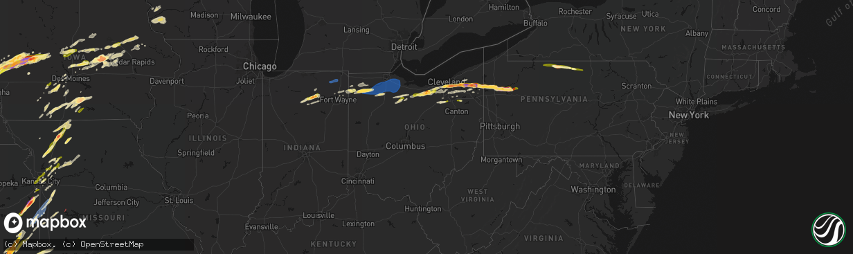
Hail Map in Ohio on April 15, 2026
The weather event in Ohio on April 15, 2026 includes Hail, Wind, and Tornado maps. 17 states and 1,134 cities were impacted and suffered possible damage. The total estimated number of properties impacted is 119,193.
Hail
Wind
Tornado
119,193
Estimated number of impacted properties by a 1.00" hail or larger77,252
Estimated number of impacted properties by a 1.75" hail or larger0
Estimated number of impacted properties by a 2.50" hail or largerStorm reports in Ohio
Ohio
| Date | Description |
|---|---|
| 04/15/20266:26 PM CDT | Trees downed in and around hubbard. |
| 04/15/20266:25 PM CDT | Tree downed. Time estimated via radar. |
| 04/15/20266:25 PM CDT | Trees downed in brookfield. |
| 04/15/20266:05 PM CDT | Quarter sized hail reported by the public. |
| 04/15/20266:04 PM CDT | A couple of trees downed in milton twp near the trumbull co line. |
| 04/15/20265:57 PM CDT | Several trees downed in suffield township. |
| 04/15/20265:48 PM CDT | Social media images of large hail and damaged vehicles. |
| 04/15/20265:46 PM CDT | A few trees downed in sawyerwood/springfield twp. |
| 04/15/20265:45 PM CDT | Two downed trees in hiram. |
| 04/15/20265:40 PM CDT | Images shared via social media of large hail. |
| 04/15/20265:30 PM CDT | Mainly dime to penny-sized but some as large as quarters. |
| 04/15/20265:26 PM CDT | Straight line wind damage... Several power poles |
| 04/15/20265:16 PM CDT | Public report of significant accumulation of one inch and greater hail. |
| 04/15/20265:13 PM CDT | Report from mping: ping pong ball |
| 04/15/20265:13 PM CDT | Report from mping: ping pong ball |
| 04/15/20265:10 PM CDT | Several trees downed in hartford twp. |
| 04/15/20265:08 PM CDT | Numerous branches broken. |
| 04/15/20265:06 PM CDT | Intersection of sr 88 and phillips rice rd. |
| 04/15/20265:00 PM CDT | Significant accumulation of hail on i271 creating a slush and slowing traffic. |
| 04/15/20265:00 PM CDT | Tree down. |
| 04/15/20264:53 PM CDT | A local report indicates 1.00 inch wind near Grafton |
| 04/15/20264:48 PM CDT | Time estimated via radar. |
| 04/15/20264:48 PM CDT | Corrects previous hail report from bristolville. Social media images of large hail and damaged vehicles. |
| 04/15/20264:48 PM CDT | Significant damage from a combination of wind and hail in bristolville... Including downed trees and power polls along with damage to siding... Roofs and windows. |
| 04/15/20264:48 PM CDT | Report from mping: golf ball |
| 04/15/20264:46 PM CDT | Time estimated via radar. |
| 04/15/20264:27 PM CDT | A local report indicates 1.75 inch wind near Kipton |
| 04/15/20264:21 PM CDT | Time estimated via radar. |
| 04/15/20264:20 PM CDT | Report from mping: golf ball |
| 04/15/20264:18 PM CDT | Several trees down. Time estimated via radar. |
| 04/15/20264:16 PM CDT | Corrects previous hail report from bainbridge. Public report of significant accumulation of one inch and greater hail. |
| 04/15/20264:10 PM CDT | Significant storm damage in solon from a combination of wind and hail. Numerous trees were downed with some falling onto houses. Damage to siding and windows due to win |
| 04/15/20264:09 PM CDT | Delayed report. Time estimated via radar. |
| 04/15/20264:09 PM CDT | A local report indicates 1.25 inch wind near 4 WSW Republic |
| 04/15/20264:09 PM CDT | A local report indicates 1.00 inch wind near Solon |
| 04/15/20264:05 PM CDT | Corrects previous tstm wnd dmg report from tiffin. Straight line wind damage... Several power poles |
| 04/15/20264:03 PM CDT | A local report indicates 2.00 inch wind near 1 NNE Bedford |
| 04/15/20264:03 PM CDT | A local report indicates 1.00 inch wind near 5 SSW Norwalk |
| 04/15/20264:03 PM CDT | A local report indicates 1.75 inch wind near 1 SW Maple Heights |
| 04/15/20264:03 PM CDT | Hail lasted 10 to 15 minutes ranging in size from 1.00 to 2.00 inches in diameter. |
| 04/15/20264:02 PM CDT | Picture of hail slightly over 2 inch in diameter hail received from bedford. |
| 04/15/20264:00 PM CDT | A local report indicates 1.25 inch wind near Bedford |
| 04/15/20263:58 PM CDT | A local report indicates 1.50 inch wind near 1 NNE Seven Hills |
| 04/15/20263:55 PM CDT | A local report indicates 1.50 inch wind near 1 N Seven Hills |
| 04/15/20263:55 PM CDT | Updated previous hail report from 1 n seven hills to 2 inch diameter hail. |
| 04/15/20263:48 PM CDT | A local report indicates 1.00 inch wind near 1 ESE Parma Heights |
| 04/15/20263:47 PM CDT | A local report indicates 1.00 inch wind near 1 NE Parma |
| 04/15/20263:40 PM CDT | Corrects previous hail report from solon. Images shared via social media of large hail. |
| 04/15/20263:34 PM CDT | A local report indicates 1.00 inch wind near 3 E Tiffin |
| 04/15/20263:30 PM CDT | 70mph wind gusts. |
| 04/15/20263:26 PM CDT | Corrects previous tstm wnd dmg report from tiffin. Straight line wind damage... Several power poles |
| 04/15/20263:12 PM CDT | Tree and power-lines downed in bowling green. |
| 04/15/20263:08 PM CDT | Collapsed barn. Time estimated via radar. |
| 04/15/20263:03 PM CDT | Tree downed partially onto a moving car on oh 281 between milton road and weston road outside of custar. |
| 04/15/20263:03 PM CDT | Tree and power-lines downed. Time estimated via radar. |
| 04/15/20263:00 PM CDT | Barn collapse. |
| 04/15/20263:00 PM CDT | Barn collapse. |
| 04/15/20262:32 PM CDT | A local report indicates 1.50 inch wind near Defiance |
| 04/15/20262:05 PM CDT | A local report indicates 1.00 inch wind near Hicksville |
All States Impacted by Hail Map on April 15, 2026
Cities Impacted by Hail Map on April 15, 2026
- Genoa, NE
- Kingston, OK
- Monroe, NE
- Saybrook, IL
- Columbus, NE
- Bellwood, NE
- Schuyler, NE
- Leigh, NE
- David City, NE
- Rogers, NE
- Clarkson, NE
- Dodge, NE
- Howells, NE
- North Bend, NE
- Ames, NE
- Hooper, NE
- Scribner, NE
- Tekamah, NE
- Craig, NE
- Herman, NE
- Winslow, NE
- Nashoba, OK
- Little Sioux, IA
- Mondamin, IA
- Arlington, NE
- Pisgah, IA
- Logan, IA
- Woodbine, IA
- Moorhead, IA
- Dunlap, IA
- Dow City, IA
- Earling, IA
- Onawa, IA
- West Point, NE
- Denison, IA
- Arion, IA
- Defiance, IA
- Charter Oak, IA
- Ute, IA
- Soldier, IA
- Manilla, IA
- Westside, IA
- Vail, IA
- Deloit, IA
- Aspinwall, IA
- Manning, IA
- Arcadia, IA
- Breda, IA
- Kiron, IA
- Halbur, IA
- Carroll, IA
- Templeton, IA
- Hampton, NE
- Aurora, NE
- Giltner, NE
- Harvard, NE
- Irwin, IA
- Glidden, IA
- Henderson, NE
- Rochester, IN
- Kewanna, IN
- Scranton, IA
- Ralston, IA
- Churdan, IA
- Jefferson, IA
- Silver Lake, IN
- Claypool, IN
- Akron, IN
- Warsaw, IN
- Pierceton, IN
- Coon Rapids, IA
- Dedham, IA
- Waco, NE
- York, NE
- Mentone, IN
- Utica, NE
- Staplehurst, NE
- Gresham, NE
- Paton, IA
- Ulysses, NE
- Seward, NE
- Dwight, NE
- Bee, NE
- Winona Lake, IN
- Bradshaw, NE
- Roann, IN
- Macy, IN
- Brainard, NE
- Valparaiso, NE
- Dana, IA
- Weston, NE
- Rome City, IN
- Kendallville, IN
- Hudson, IN
- Corunna, IN
- Wolcottville, IN
- Stratford, IA
- Stanhope, IA
- North Manchester, IN
- Liberty Mills, IN
- Churubusco, IN
- Huntertown, IN
- Fort Wayne, IN
- Ashley, IN
- Pleasant Lake, IN
- Wahoo, NE
- Malmo, NE
- Ceresco, NE
- Boone, IA
- Ames, IA
- Story City, IA
- Gilbert, IA
- Jewell, IA
- Colon, NE
- Roland, IA
- Randall, IA
- Mark Center, OH
- Sherwood, OH
- Hicksville, OH
- Antwerp, OH
- Cecil, OH
- Mead, NE
- Graham, TX
- Grabill, IN
- Edgerton, OH
- Dewey, OK
- Bartlesville, OK
- Radcliffe, IA
- Alden, IA
- Ellsworth, IA
- Olney, TX
- Newcastle, TX
- Auburn, IN
- Leo, IN
- Spencerville, IN
- Blissfield, MI
- Riga, MI
- Ottawa Lake, MI
- Ida, MI
- Petersburg, MI
- Saint Joe, IN
- Harlan, IN
- McCallsburg, IA
- Yutan, NE
- Fremont, NE
- Valley, NE
- Defiance, OH
- Barnsdall, OK
- Ochelata, OK
- Ramona, OK
- Iowa Falls, IA
- Skiatook, OK
- Wann, OK
- New Haven, IN
- Copan, OK
- Holgate, OH
- Coffeyville, KS
- Dearing, KS
- Ackley, IA
- Aplington, IA
- Hominy, OK
- Archbold, OH
- Bryan, OH
- Stryker, OH
- Ney, OH
- Evansport, OH
- Napoleon, OH
- Liberty, KS
- Hubbard, IA
- Zearing, IA
- Independence, KS
- Cherryvale, KS
- Malinta, OH
- Dennis, KS
- Parsons, KS
- Galesburg, KS
- Thayer, KS
- Union, IA
- New Providence, IA
- Nowata, OK
- Austinville, IA
- Hamler, OH
- Conrad, IA
- Erie, KS
- Beaman, IA
- Stuart, IA
- Huxley, IA
- Cambridge, IA
- Merkel, TX
- Eldora, IA
- Whitten, IA
- Liscomb, IA
- Blair, NE
- Kennard, NE
- Slater, IA
- Delaware, OK
- Leipsic, OH
- Polk City, IA
- Parkersburg, IA
- Custar, OH
- Cygnet, OH
- Rudolph, OH
- Martin, OH
- Haskins, OH
- Dunbridge, OH
- Bowling Green, OH
- Pemberville, OH
- Woodville, OH
- Stony Ridge, OH
- New Bavaria, OH
- Bradner, OH
- Liberty Center, OH
- Risingsun, OH
- Walbridge, OH
- Gibsonburg, OH
- Wayne, OH
- Portage, OH
- Helena, OH
- Weston, OH
- Luckey, OH
- McClure, OH
- Tontogany, OH
- Elmore, OH
- Grelton, OH
- Deshler, OH
- Perrysburg, OH
- Genoa, OH
- Clay Center, OH
- Millbury, OH
- Waterville, OH
- Graytown, OH
- Milton Center, OH
- Grand Rapids, OH
- Chanute, KS
- Dexter, IA
- Missouri Valley, IA
- Lenapah, OK
- Grafton, OH
- North Ridgeville, OH
- Elyria, OH
- Lagrange, OH
- Columbia Station, OH
- Saint Paul, KS
- Hoytville, OH
- North Baltimore, OH
- Walnut, KS
- Pawnee, OK
- Fairfax, OK
- McComb, OH
- Pawhuska, OK
- Modale, IA
- Magnolia, IA
- Seymour, TX
- Wichita Falls, TX
- Holliday, TX
- Maxwell, IA
- Collins, IA
- Tiffin, OH
- Bloomville, OH
- Republic, OH
- Kansas, OH
- Rocky Ridge, OH
- Lindsey, OH
- Fremont, OH
- Fostoria, OH
- Burgoon, OH
- Oak Harbor, OH
- McCutchenville, OH
- Blockton, IA
- Bedford, IA
- Hawley, TX
- Elsmore, KS
- Stark, KS
- Savonburg, KS
- Olmsted Falls, OH
- Gladbrook, IA
- Prescott, IA
- Corning, IA
- Abilene, TX
- Anson, TX
- Wynona, OK
- Independence, OH
- Cleveland, OH
- State Center, IA
- Rhodes, IA
- Maple Heights, OH
- Bedford, OH
- Lueders, TX
- S Coffeyville, OK
- Diagonal, IA
- Edna, KS
- Brookpark, OH
- Okemah, OK
- Mapleton, KS
- Albany, TX
- Berea, OH
- North Royalton, OH
- Hudson, IA
- Welch, OK
- Shannon City, IA
- Traer, IA
- Creston, IA
- Greenfield, IA
- Reinbeck, IA
- Seminole, OK
- Moran, KS
- Orient, IA
- Wewoka, OK
- Solon, OH
- Chagrin Falls, OH
- Novelty, OH
- Bartlett, KS
- Chetopa, KS
- Oswego, KS
- Columbus, KS
- Winterset, IA
- Macksburg, IA
- Laurel, IA
- Marshalltown, IA
- Benton, IA
- Mount Ayr, IA
- Collins, OH
- Norwalk, OH
- Bascom, OH
- Buckingham, IA
- Waterloo, IA
- La Porte City, IA
- Stewartsville, MO
- Rea, MO
- King City, MO
- Guilford, MO
- Melbourne, IA
- Castle, OK
- Prescott, KS
- Mound City, KS
- Pleasanton, KS
- Lenox, IA
- Fulton, KS
- Clearfield, IA
- Urbandale, IA
- Grimes, IA
- Blue Mound, KS
- Brecksville, OH
- Kansas City, KS
- Shawnee, KS
- Kansas City, MO
- Riverside, MO
- Middlefield, OH
- Newbury, OH
- Burton, OH
- Hiram, OH
- Liberty, MO
- Kearney, MO
- Holt, MO
- Excelsior Springs, MO
- Lawson, MO
- Wellington, OH
- Oberlin, OH
- Monroeville, OH
- Wakeman, OH
- Willard, OH
- Kipton, OH
- Osawatomie, KS
- Garwin, IA
- Bellevue, OH
- Johnston, IA
- Greeley, KS
- Parker, KS
- Lane, KS
- Plattsburg, MO
- Osborn, MO
- Cameron, MO
- Maysville, MO
- Neodesha, KS
- Haverhill, IA
- Afton, IA
- Strongsville, OH
- Amsterdam, MO
- Garnett, KS
- New London, OH
- Steuben, WI
- Eastman, WI
- Stanberry, MO
- Tingley, IA
- Attica, OH
- Redding, IA
- Northfield, OH
- Le Grand, IA
- Montour, IA
- Jesup, IA
- Brandon, IA
- Van Meter, IA
- North Bloomfield, OH
- West Farmington, OH
- Waukee, IA
- West Des Moines, IA
- Ferguson, IA
- Gilman, IA
- Toledo, IA
- Leesburg, IN
- Polo, MO
- Kingston, MO
- Adrian, MO
- Grand River, IA
- Ellston, IA
- Paola, KS
- Weatherby, MO
- Winston, MO
- Wauzeka, WI
- Boscobel, WI
- Dyess Afb, TX
- Hume, MO
- Rich Hill, MO
- Henrietta, TX
- Garrettsville, OH
- Bristolville, OH
- Throckmorton, TX
- Woodson, TX
- Tye, TX
- Clive, IA
- Earlham, IA
- Gays Mills, WI
- Butler, MO
- North Fairfield, OH
- Greenwich, OH
- Des Moines, IA
- Pattonsburg, MO
- Fort Scott, KS
- Comanche, OK
- Tama, IA
- Clutier, IA
- Cortland, OH
- Farmdale, OH
- Uniontown, KS
- Bethany, MO
- Breckenridge, TX
- Murray, IA
- Osceola, IA
- Independence, IA
- Gilman City, MO
- Coffey, MO
- Weir, KS
- Galena, KS
- Pittsburg, KS
- Louisburg, KS
- Mingo, IA
- Bondurant, IA
- Asbury, MO
- Carl Junction, MO
- Scammon, KS
- Valley City, OH
- Bradford, PA
- Lewis Run, PA
- Harrisonville, MO
- Garden City, MO
- East Lynne, MO
- Pleasant Hill, MO
- Archie, MO
- Hepler, KS
- Redfield, KS
- Baxter, IA
- Spring Hill, KS
- Bucyrus, KS
- Kellerton, IA
- Greenville, PA
- Fowler, OH
- Kinsman, OH
- Burghill, OH
- Independence, MO
- Bloomington, WI
- Bagley, WI
- Patch Grove, WI
- Prairie Du Chien, WI
- Truro, IA
- New Virginia, IA
- Strasburg, MO
- Kingsville, MO
- Ridgeway, MO
- Cainsville, MO
- Richmond, MO
- Dysart, IA
- Masonville, IA
- Winthrop, IA
- Oronogo, MO
- Jasper, MO
- Aurora, IA
- Weldon, IA
- Norwalk, IA
- Prole, IA
- Webb City, MO
- Mount Hope, WI
- Brunswick, OH
- Broadview Heights, OH
- Hinckley, OH
- Sycamore, OH
- New Riegel, OH
- Elberon, IA
- Vinita, OK
- Aurora, OH
- Lamoni, IA
- Eagleville, MO
- Cumming, IA
- Lees Summit, MO
- Transfer, PA
- Port Allegany, PA
- Turtlepoint, PA
- Newton, IA
- Keystone, IA
- Garrison, IA
- Richfield, OH
- Peninsula, OH
- Carrollton, MO
- Dawn, MO
- Norborne, MO
- Braymer, MO
- Lone Jack, MO
- Loving, TX
- Medina, OH
- Huntsburg, OH
- Chardon, OH
- Saint Charles, IA
- Missouri City, MO
- Blythedale, MO
- Princeton, MO
- Trenton, MO
- Jamesport, MO
- Carthage, MO
- Golden City, MO
- Seville, OH
- Creston, OH
- Woodburn, IA
- Lucas, IA
- Manchester, IA
- Dundee, IA
- Lancaster, WI
- Woodman, WI
- Fennimore, WI
- Buckner, MO
- Olathe, KS
- Overland Park, KS
- Southington, OH
- Sterling, OH
- Westfield Center, OH
- Burbank, OH
- Smethport, PA
- Derby, IA
- Grain Valley, MO
- Oak Grove, MO
- Blue Springs, MO
- Sharpsville, PA
- Chariton, IA
- Wadsworth, OH
- Barberton, OH
- Gifford, PA
- Roulette, PA
- Shinglehouse, PA
- Eldred, PA
- Coudersport, PA
- Stitzer, WI
- Grinnell, IA
- Rittman, OH
- Humeston, IA
- Hudson, OH
- Montrose, MO
- Bogard, MO
- Hadley, PA
- Stoneboro, PA
- Clarks Mills, PA
- Fredonia, PA
- Vinton, IA
- Rayville, MO
- Lathrop, MO
- Streetsboro, OH
- Sibley, MO
- Ryan, OK
- Van Horne, IA
- Windsor, OH
- Lamar, MO
- Van Wert, IA
- Mercer, PA
- Warren, OH
- Cuyahoga Falls, OH
- Jackson Center, PA
- Urbana, IA
- Center Point, IA
- Doylestown, OH
- Williamson, IA
- Martinsville, MO
- Lineville, IA
- Mercer, MO
- Sandy Lake, PA
- Polk, PA
- Franklin, PA
- Russell, IA
- Coggon, IA
- New Hampton, MO
- Terral, OK
- Archer City, TX
- Scotland, TX
- Mantua, OH
- Livingston, WI
- Bryson, TX
- Moran, TX
- Windham, OH
- Leawood, KS
- Miami, OK
- Malcom, IA
- Chelsea, IA
- Genesee, PA
- Turney, MO
- Tina, MO
- Hale, MO
- Ulysses, PA
- Munroe Falls, OH
- Amoret, MO
- Cowgill, MO
- Orrick, MO
- Mogadore, OH
- Stilwell, KS
- Atwater, OH
- Rootstown, OH
- Clinton, MO
- Emlenton, PA
- Kennerdell, PA
- Cranberry, PA
- Seneca, PA
- Chillicothe, MO
- Corydon, IA
- Baxter Springs, KS
- San Angelo, TX
- Ardmore, OK
- Ryan, IA
- Melrose, IA
- Lovilia, IA
- Ringling, OK
- Belle Plaine, IA
- Jacksboro, TX
- Central City, IA
- Galeton, PA
- Luzerne, IA
- Walker, IA
- Kent, OH
- Lacona, IA
- Gaines, PA
- Westfield, PA
- Sabinsville, PA
- Foster, MO
- La Cygne, KS
- Drexel, MO
- Kossuth, PA
- Shippenville, PA
- Venus, PA
- Fryburg, PA
- Lucinda, PA
- Marble, PA
- Kidder, MO
- Gallatin, MO
- Jameson, MO
- Burbank, OK
- Riverton, KS
- Hamlin, IA
- Audubon, IA
- Exira, IA
- Hamilton, MO
- Windthorst, TX
- Melcher Dallas, IA
- Knox, PA
- Perkins, OK
- Hopkinton, IA
- Coyle, OK
- Stillwater, OK
- Delhi, IA
- Meadville, MO
- Blairstown, IA
- Vienna, OH
- Stockton, IL
- Lena, IL
- Lexington, NE
- Greeley, CO
- Maxwell, NE
- Amherst, NE
- New Raymer, CO
- Thurman, IA
- Beaver Crossing, NE
- Moorefield, NE
- Cozad, NE
- Kearney, NE
- Pleasant Dale, NE
- Garden Grove, IA
- Red Oak, IA
- Stoneham, CO
- Sterling, CO
- Weeping Water, NE
- Hamilton, CO
- Brady, NE
- Galeton, CO
- Fairview, UT
- Fort Collins, CO
- Fleming, CO
- Venango, NE
- Helper, UT
- Glen Haven, CO
- Timnath, CO
- Lincoln, NE
- Waverly, NE
- Randolph, IA
- Elmwood, NE
- Merino, CO
- Holyoke, CO
- Dickens, NE
- Sidney, IA
- Meeker, CO
- Plattsmouth, NE
- Nephi, UT
- Farnam, NE
- Alvo, NE
- Wallace, NE
- Ely, NV
- Kremmling, CO
- Clarinda, IA
- Nehawka, NE
- Malcolm, NE
- Gravity, IA
- Millerton, IA
- Gill, CO
- Windsor, CO
- Imogene, IA
- Elsie, NE
- Estes Park, CO
- Riverdale, NE
- Doniphan, NE
- Loveland, CO
- Murdock, NE
- Phillips, NE
- Tabor, IA
- Amherst, CO
- Madrid, NE
- Oak Creek, CO
- Overton, NE
- Steamboat Springs, CO
- Briggsdale, CO
- Rangely, CO
- Gibbon, NE
- Nodaway, IA
- Eaton, CO
- Duchesne, UT
- Wellfleet, NE
- Maywood, NE
- Grand Island, NE
- Vernal, UT
- Haxtun, CO
- Wood River, NE
- Essex, IA
- Alda, NE
- Milford, NE
- Elm Creek, NE
- Villisca, IA
- Curtis, NE
- Union, NE
- Eagle, NE
- Grant, NE
- Hayden, CO
- Murray, NE
- Shelton, NE
- Drake, CO
- Wellsboro, PA
- Lone Grove, OK
- Miles, TX
- Woodhull, NY
- Addison, NY
- Overbrook, OK
- Graford, TX
- Mound Valley, KS
- Altamont, KS
- West Middlesex, PA
- Hubbard, OH
- Masury, OH
- Mystic, IA
- Tishomingo, OK
- Wilson, OK
- Allerton, IA
- Promise City, IA
- Purcell, MO
- Alba, MO
- Bronte, TX
- Albia, IA
- Moravia, IA
- Milburn, OK
- Stonewall, OK
- Marengo, IA
- Lowry City, MO
- Osceola, MO
- Brookfield, OH
- Laclede, MO
- Ringgold, TX
- Rowena, TX
- Strawn, TX
- Galt, MO
- Perrin, TX
- Dumont, IA
- Geneva, IA
- Sunset, TX
- Sulphur, OK
- Mill Creek, OK
- Mannsville, OK
- Tupelo, OK
- Lawrenceville, PA
- Lindley, NY
- Guthrie Center, IA
- Lucerne, MO
- Painted Post, NY
- Nocona, TX
- Winslow, IL
- Ballinger, TX
- Fairfax, IA
- Walford, IA
- Norway, IA
- Laredo, MO
- Hedrick, IA
- Pine City, NY
- Corning, NY
- Millerton, PA
- Clarington, PA
- Sigel, PA
- Unionville, MO
- Powersville, MO
- Bowie, TX
- Chico, TX
- Bridgeport, TX
- Alvord, TX
- Gillett, PA
- Wellston, OK
- Forestburg, TX
- Linneus, MO
- Bayard, IA
- Washington, IA
- Hampton, IA
- Cedar Rapids, IA
- Havana, KS
- Caney, KS
- Grove City, PA
- Centerville, IA
- Seymour, IA
- Cincinnati, IA
- Sigourney, IA
- Ollie, IA
- West Mineral, KS
- McCune, KS
- Hayesville, IA
- Paint Rock, TX
- Wellsburg, NY
- Wapanucka, OK
- Ridgway, PA
- Grand Junction, IA
- Keota, IA
- West Chester, IA
- Panora, IA
- Bagley, IA
- Ainsworth, IA
- Columbia Cross Roads, PA
- Tyro, KS
- Oil City, PA
- Rosston, TX
- Pollock, MO
- Coalgate, OK
- Athens, PA
- Sayre, PA
- Cherokee, KS
- Riverside, IA
- Coleman, OK
- Moulton, IA
- Udell, IA
- Exline, IA
- Linn Creek, MO
- Yale, IA
- Muenster, TX
- Decatur, TX
- Montreal, MO
- Gainesville, TX
- Atlanta, MO
- Milan, PA
- Janesville, WI
- Lindsay, TX
- Wellman, IA
- Camdenton, MO
- Letts, IA
- Ulster, PA
- Lanark, IL
- Mount Carroll, IL
- Dawson, IA
- Perry, IA
- Cuba, MO
- Rosebud, MO
- Sullivan, MO
- Owensville, MO
- Opolis, KS
- Columbus Junction, IA
- Lone Tree, IA
- Conesville, IA
- Valley View, TX
- Preston, IA
- Maquoketa, IA
- Mertzon, TX
- Kahoka, MO
- Nichols, IA
- Milton, WI
- Madill, OK
- Grand Mound, IA
- Wheatland, IA
- Lost Nation, IA
- West Branch, IA
- Iowa City, IA
- Whitt, TX
- Thackerville, OK
- Marietta, OK
- Whitesboro, TX
- Era, TX
- Centrahoma, OK
- Shidler, OK
- Elkhorn, WI
- Pecatonica, IL
- German Valley, IL
- Leaf River, IL
- Ridott, IL
- Gordonville, TX
- Madrid, IA
- Lohrville, IA
- Thomson, IL
- Savanna, IL
- Bouton, IA
- Sanger, TX
- Gerald, MO
- Beaufort, MO
- Leslie, MO
- Lebanon, MO
- Farnhamville, IA
- Saint Patrick, MO
- Jamaica, IA
- Dallas Center, IA
- Muscatine, IA
- Pottsboro, TX
- Gowrie, IA
- Woodward, IA
- Adel, IA
- Alexandria, MO
- Wayland, MO
- Kenefic, OK
- Lewistown, MO
- Ewing, MO
- La Belle, MO
- Winnebago, IL
- Lane, OK
- Stringtown, OK
- Prairie Village, KS
- Pilot Point, TX
- Collinsville, TX
- North Prairie, WI
- Mukwonago, WI
- Waukesha, WI
- Eagle, WI
- Granger, IA
- Illinois City, IL
- Nevada, IA
- Hales Corners, WI
- Milwaukee, WI
- New Berlin, WI
- Muskego, WI
- Big Bend, WI
- Sheldahl, IA
- Kelley, IA
- Rockford, IL
- Keokuk, IA
- Vienna, MO
- Dixon, MO
- Monticello, MO
- La Grange, MO
- Denison, TX
- Bells, TX
- Shannon, IL
- Tioga, TX
- Durand, IL
- Wales, WI
- Saint James, MO
- Rolla, MO
- Vichy, MO
- Poplar Grove, IL
- Capron, IL
- Belle, MO
- Bland, MO
- Canton, MO
- Ravenna, TX
- Colo, IA
- Harcourt, IA
- Dayton, IA
- Boxholm, IA
- Ogden, IA
- Pilot Mound, IA
- Burnside, IA
- Lehigh, IA
- Fort Dodge, IA
- Andes, NY
- Margaretville, NY
- Warsaw, IL
- Hamilton, IL
- Hendrix, OK
- Callender, IA
- Talihina, OK
- Clayton, OK
- Sherman, TX
- Roscoe, NY
- Howe, TX
- Fleischmanns, NY
- Pine Hill, NY
- Big Indian, NY
- Arkville, NY
- Ponca City, OK
- Bangs, TX
- Santa Anna, TX
- Mindenmines, MO
- Neck City, MO
- Liberal, MO
- Savoy, TX
- Brownwood, TX
- Clemons, IA
- Tonkawa, OK
- Quapaw, OK
- Charleston, AR
- Lavaca, AR
- Greenwood, AR
- Hackett, AR
- Booneville, AR
- Fort Smith, AR
- Early, TX
- Grundy Center, IA
- Albion, IA
- Lincoln, IA
- High Falls, NY
- Stone Ridge, NY
- Accord, NY
- Zephyr, TX
- Blanket, TX
- Cottekill, NY
- Unityville, PA
- Comanche, TX
- Ozark, AR
- Scranton, AR
- Subiaco, AR
- Paris, AR
- Magazine, AR
- Ratcliff, AR
- Branch, AR
- New Blaine, AR
- Delaware, AR
- Havana, AR
- Belleville, AR
- Danville, AR
- Dardanelle, AR
- Blue Mountain, AR
- Russellville, AR
- Lamar, AR
- London, AR
- Knoxville, AR
- Ola, AR
- Clarksville, AR
- Hartman, AR
- Dover, AR
- Hagarville, AR
- Hector, AR
- Pelsor, AR
- Pottsville, AR
- Atkins, AR
- Gustine, TX
- Talala, OK
- Carlton, TX
- Hico, TX
- Chelsea, OK
- Hattieville, AR
- Jerusalem, AR
- Cleveland, AR
- Bates City, MO
- Odessa, MO
- Holden, MO
- Bourbon, MO
- Leasburg, MO
- Wyoming, PA
- Shavertown, PA
- Luzerne, PA
- Pittston, PA
- Kingston, PA
- Dallas, PA
- Clarks Summit, PA
- Wilkes Barre, PA
- Moscow, PA
- Old Forge, PA
- Scranton, PA
- Taylor, PA
- Duryea, PA
- Moosic, PA
- Gouldsboro, PA
- Lake Ariel, PA
- Newfoundland, PA
- Sterling, PA
- New Wilmington, PA
- Wheatland, PA
- Hermitage, PA
- Girard, OH
- Belton, MO
- Leon, IA
- Davis City, IA
- Muncy, PA
- Trout Run, PA
- Muncy Valley, PA
- Benton, PA
- Williamsport, PA
- Montoursville, PA
- Hughesville, PA
- Cogan Station, PA
- Garden City, IA
- Clark, PA
- Elburn, IL
- Maple Park, IL
- Sugar Grove, IL
- Geneva, IL
- Eddyville, IA
- Cedar, IA
- Oskaloosa, IA
- Fremont, IA
- Delta, IA
- Eldridge, MO
- Lockwood, MO
- Joplin, MO
- Carterville, MO
- Golden, IL
- Machias, NY


