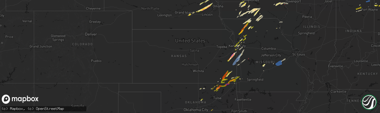
Hail Map in Kansas on April 15, 2026
The weather event in Kansas on April 15, 2026 includes Hail, Wind, and Tornado maps. 17 states and 1,134 cities were impacted and suffered possible damage. The total estimated number of properties impacted is 55,176.
Hail
Wind
Tornado
55,176
Estimated number of impacted properties by a 1.00" hail or larger10,158
Estimated number of impacted properties by a 1.75" hail or larger9,502
Estimated number of impacted properties by a 2.50" hail or largerStorm reports in Kansas
Kansas
| Date | Description |
|---|---|
| 04/15/20266:15 PM CDT | Quarter size hail. |
| 04/15/20265:45 PM CDT | Estimated quarter sized hail from spotter... Time estimated by radar. |
| 04/15/20265:43 PM CDT | Report from mping: quarter |
| 04/15/20265:41 PM CDT | Mping report. |
| 04/15/20265:34 PM CDT | Report relayed via social media. Time estimated from radar. |
| 04/15/20265:20 PM CDT | Report from mping: quarter |
| 04/15/20265:11 PM CDT | Report from mping: quarter |
| 04/15/20264:50 PM CDT | Report relayed via social media. Time estimated from radar. |
| 04/15/20264:50 PM CDT | Social media report. Time estimated from radar. |
| 04/15/20264:47 PM CDT | Hail lasted about ten minutes. Time estimated from radar. |
| 04/15/20264:47 PM CDT | Social media report. Time estimated from radar. |
| 04/15/20264:45 PM CDT | Powerlines down. |
| 04/15/20264:44 PM CDT | Golf ball size hail at the paola golf club. Time estimated from radar. |
| 04/15/20264:41 PM CDT | Social media report. Time estimated from radar. |
| 04/15/20264:41 PM CDT | Time estimated from radar. |
| 04/15/20264:40 PM CDT | Pws measured wind gust... Time estimated from radar. |
| 04/15/20264:40 PM CDT | Downed wires near west street. Time estimated from radar. |
| 04/15/20264:40 PM CDT | Measured 2.5 inch hail in downtown paola. Time estimated from radar. |
| 04/15/20264:40 PM CDT | Time estimated from radar. |
| 04/15/20264:39 PM CDT | A local report indicates 3.00 inch wind near 1 SE Paola |
| 04/15/20264:38 PM CDT | Social media report. Time estimated from radar. |
| 04/15/20264:38 PM CDT | Social media report. Time estimated from radar. |
| 04/15/20264:38 PM CDT | Social media report. Time estimated from radar. |
| 04/15/20264:37 PM CDT | Photo from social media shows hail approximately baseball sized. Time estimated from radar. |
| 04/15/20264:36 PM CDT | Trees and powerlines down as well as considerable hail damage. |
| 04/15/20264:35 PM CDT | Report of ping pong sized hail. Time estimated from radar. |
| 04/15/20264:35 PM CDT | Social media report. Damaged roof of a house. Time estimated from radar. |
| 04/15/20264:35 PM CDT | Tree down... Road closed due to storm damage. |
| 04/15/20264:32 PM CDT | Several social media photos and videos of hail up to tennis ball size in osawatomie. Multiple homes and vehicles were damaged... With many windows and windshields crack |
| 04/15/20264:31 PM CDT | Quarter size hail. |
| 04/15/20264:31 PM CDT | Ping pong size hail... 40mph wind gust... Torrential rainfall. |
| 04/15/20264:22 PM CDT | Also report of 60mph winds. |
| 04/15/20264:15 PM CDT | A local report indicates 1.25 inch wind near Walnut |
| 04/15/20264:11 PM CDT | A local report indicates 1.00 inch wind near Chetopa |
| 04/15/20264:07 PM CDT | A local report indicates 62 MPH wind near Pleasanton |
| 04/15/20264:06 PM CDT | Numerous broken windows in town. |
| 04/15/20264:01 PM CDT | Downed wires near 400th road. Time estimated from radar. |
| 04/15/20263:56 PM CDT | Mping report. |
| 04/15/20263:49 PM CDT | A local report indicates 1.25 inch wind near 1 W Coffeyville |
| 04/15/20263:21 PM CDT | Hospital em reported golf ball sized hail at 160th and marshall in shaw. |
| 04/15/20262:57 PM CDT | Semi was blown over on us 400 just east of us 169. |
| 04/15/20262:51 PM CDT | A local report indicates 1.75 inch wind near Cherryvale |
| 04/15/20262:48 PM CDT | Location estimated. |
| 04/15/20262:48 PM CDT | Location estimated. |
| 04/14/20268:02 PM CDT | Mostly dimes with a few quarters and torrential rainfall. |
All States Impacted by Hail Map on April 15, 2026
Cities Impacted by Hail Map on April 15, 2026
- Genoa, NE
- Kingston, OK
- Monroe, NE
- Saybrook, IL
- Columbus, NE
- Bellwood, NE
- Schuyler, NE
- Leigh, NE
- David City, NE
- Rogers, NE
- Clarkson, NE
- Dodge, NE
- Howells, NE
- North Bend, NE
- Ames, NE
- Hooper, NE
- Scribner, NE
- Tekamah, NE
- Craig, NE
- Herman, NE
- Winslow, NE
- Nashoba, OK
- Little Sioux, IA
- Mondamin, IA
- Arlington, NE
- Pisgah, IA
- Logan, IA
- Woodbine, IA
- Moorhead, IA
- Dunlap, IA
- Dow City, IA
- Earling, IA
- Onawa, IA
- West Point, NE
- Denison, IA
- Arion, IA
- Defiance, IA
- Charter Oak, IA
- Ute, IA
- Soldier, IA
- Manilla, IA
- Westside, IA
- Vail, IA
- Deloit, IA
- Aspinwall, IA
- Manning, IA
- Arcadia, IA
- Breda, IA
- Kiron, IA
- Halbur, IA
- Carroll, IA
- Templeton, IA
- Hampton, NE
- Aurora, NE
- Giltner, NE
- Harvard, NE
- Irwin, IA
- Glidden, IA
- Henderson, NE
- Rochester, IN
- Kewanna, IN
- Scranton, IA
- Ralston, IA
- Churdan, IA
- Jefferson, IA
- Silver Lake, IN
- Claypool, IN
- Akron, IN
- Warsaw, IN
- Pierceton, IN
- Coon Rapids, IA
- Dedham, IA
- Waco, NE
- York, NE
- Mentone, IN
- Utica, NE
- Staplehurst, NE
- Gresham, NE
- Paton, IA
- Ulysses, NE
- Seward, NE
- Dwight, NE
- Bee, NE
- Winona Lake, IN
- Bradshaw, NE
- Roann, IN
- Macy, IN
- Brainard, NE
- Valparaiso, NE
- Dana, IA
- Weston, NE
- Rome City, IN
- Kendallville, IN
- Hudson, IN
- Corunna, IN
- Wolcottville, IN
- Stratford, IA
- Stanhope, IA
- North Manchester, IN
- Liberty Mills, IN
- Churubusco, IN
- Huntertown, IN
- Fort Wayne, IN
- Ashley, IN
- Pleasant Lake, IN
- Wahoo, NE
- Malmo, NE
- Ceresco, NE
- Boone, IA
- Ames, IA
- Story City, IA
- Gilbert, IA
- Jewell, IA
- Colon, NE
- Roland, IA
- Randall, IA
- Mark Center, OH
- Sherwood, OH
- Hicksville, OH
- Antwerp, OH
- Cecil, OH
- Mead, NE
- Graham, TX
- Grabill, IN
- Edgerton, OH
- Dewey, OK
- Bartlesville, OK
- Radcliffe, IA
- Alden, IA
- Ellsworth, IA
- Olney, TX
- Newcastle, TX
- Auburn, IN
- Leo, IN
- Spencerville, IN
- Blissfield, MI
- Riga, MI
- Ottawa Lake, MI
- Ida, MI
- Petersburg, MI
- Saint Joe, IN
- Harlan, IN
- McCallsburg, IA
- Yutan, NE
- Fremont, NE
- Valley, NE
- Defiance, OH
- Barnsdall, OK
- Ochelata, OK
- Ramona, OK
- Iowa Falls, IA
- Skiatook, OK
- Wann, OK
- New Haven, IN
- Copan, OK
- Holgate, OH
- Coffeyville, KS
- Dearing, KS
- Ackley, IA
- Aplington, IA
- Hominy, OK
- Archbold, OH
- Bryan, OH
- Stryker, OH
- Ney, OH
- Evansport, OH
- Napoleon, OH
- Liberty, KS
- Hubbard, IA
- Zearing, IA
- Independence, KS
- Cherryvale, KS
- Malinta, OH
- Dennis, KS
- Parsons, KS
- Galesburg, KS
- Thayer, KS
- Union, IA
- New Providence, IA
- Nowata, OK
- Austinville, IA
- Hamler, OH
- Conrad, IA
- Erie, KS
- Beaman, IA
- Stuart, IA
- Huxley, IA
- Cambridge, IA
- Merkel, TX
- Eldora, IA
- Whitten, IA
- Liscomb, IA
- Blair, NE
- Kennard, NE
- Slater, IA
- Delaware, OK
- Leipsic, OH
- Polk City, IA
- Parkersburg, IA
- Custar, OH
- Cygnet, OH
- Rudolph, OH
- Martin, OH
- Haskins, OH
- Dunbridge, OH
- Bowling Green, OH
- Pemberville, OH
- Woodville, OH
- Stony Ridge, OH
- New Bavaria, OH
- Bradner, OH
- Liberty Center, OH
- Risingsun, OH
- Walbridge, OH
- Gibsonburg, OH
- Wayne, OH
- Portage, OH
- Helena, OH
- Weston, OH
- Luckey, OH
- McClure, OH
- Tontogany, OH
- Elmore, OH
- Grelton, OH
- Deshler, OH
- Perrysburg, OH
- Genoa, OH
- Clay Center, OH
- Millbury, OH
- Waterville, OH
- Graytown, OH
- Milton Center, OH
- Grand Rapids, OH
- Chanute, KS
- Dexter, IA
- Missouri Valley, IA
- Lenapah, OK
- Grafton, OH
- North Ridgeville, OH
- Elyria, OH
- Lagrange, OH
- Columbia Station, OH
- Saint Paul, KS
- Hoytville, OH
- North Baltimore, OH
- Walnut, KS
- Pawnee, OK
- Fairfax, OK
- McComb, OH
- Pawhuska, OK
- Modale, IA
- Magnolia, IA
- Seymour, TX
- Wichita Falls, TX
- Holliday, TX
- Maxwell, IA
- Collins, IA
- Tiffin, OH
- Bloomville, OH
- Republic, OH
- Kansas, OH
- Rocky Ridge, OH
- Lindsey, OH
- Fremont, OH
- Fostoria, OH
- Burgoon, OH
- Oak Harbor, OH
- McCutchenville, OH
- Blockton, IA
- Bedford, IA
- Hawley, TX
- Elsmore, KS
- Stark, KS
- Savonburg, KS
- Olmsted Falls, OH
- Gladbrook, IA
- Prescott, IA
- Corning, IA
- Abilene, TX
- Anson, TX
- Wynona, OK
- Independence, OH
- Cleveland, OH
- State Center, IA
- Rhodes, IA
- Maple Heights, OH
- Bedford, OH
- Lueders, TX
- S Coffeyville, OK
- Diagonal, IA
- Edna, KS
- Brookpark, OH
- Okemah, OK
- Mapleton, KS
- Albany, TX
- Berea, OH
- North Royalton, OH
- Hudson, IA
- Welch, OK
- Shannon City, IA
- Traer, IA
- Creston, IA
- Greenfield, IA
- Reinbeck, IA
- Seminole, OK
- Moran, KS
- Orient, IA
- Wewoka, OK
- Solon, OH
- Chagrin Falls, OH
- Novelty, OH
- Bartlett, KS
- Chetopa, KS
- Oswego, KS
- Columbus, KS
- Winterset, IA
- Macksburg, IA
- Laurel, IA
- Marshalltown, IA
- Benton, IA
- Mount Ayr, IA
- Collins, OH
- Norwalk, OH
- Bascom, OH
- Buckingham, IA
- Waterloo, IA
- La Porte City, IA
- Stewartsville, MO
- Rea, MO
- King City, MO
- Guilford, MO
- Melbourne, IA
- Castle, OK
- Prescott, KS
- Mound City, KS
- Pleasanton, KS
- Lenox, IA
- Fulton, KS
- Clearfield, IA
- Urbandale, IA
- Grimes, IA
- Blue Mound, KS
- Brecksville, OH
- Kansas City, KS
- Shawnee, KS
- Kansas City, MO
- Riverside, MO
- Middlefield, OH
- Newbury, OH
- Burton, OH
- Hiram, OH
- Liberty, MO
- Kearney, MO
- Holt, MO
- Excelsior Springs, MO
- Lawson, MO
- Wellington, OH
- Oberlin, OH
- Monroeville, OH
- Wakeman, OH
- Willard, OH
- Kipton, OH
- Osawatomie, KS
- Garwin, IA
- Bellevue, OH
- Johnston, IA
- Greeley, KS
- Parker, KS
- Lane, KS
- Plattsburg, MO
- Osborn, MO
- Cameron, MO
- Maysville, MO
- Neodesha, KS
- Haverhill, IA
- Afton, IA
- Strongsville, OH
- Amsterdam, MO
- Garnett, KS
- New London, OH
- Steuben, WI
- Eastman, WI
- Stanberry, MO
- Tingley, IA
- Attica, OH
- Redding, IA
- Northfield, OH
- Le Grand, IA
- Montour, IA
- Jesup, IA
- Brandon, IA
- Van Meter, IA
- North Bloomfield, OH
- West Farmington, OH
- Waukee, IA
- West Des Moines, IA
- Ferguson, IA
- Gilman, IA
- Toledo, IA
- Leesburg, IN
- Polo, MO
- Kingston, MO
- Adrian, MO
- Grand River, IA
- Ellston, IA
- Paola, KS
- Weatherby, MO
- Winston, MO
- Wauzeka, WI
- Boscobel, WI
- Dyess Afb, TX
- Hume, MO
- Rich Hill, MO
- Henrietta, TX
- Garrettsville, OH
- Bristolville, OH
- Throckmorton, TX
- Woodson, TX
- Tye, TX
- Clive, IA
- Earlham, IA
- Gays Mills, WI
- Butler, MO
- North Fairfield, OH
- Greenwich, OH
- Des Moines, IA
- Pattonsburg, MO
- Fort Scott, KS
- Comanche, OK
- Tama, IA
- Clutier, IA
- Cortland, OH
- Farmdale, OH
- Uniontown, KS
- Bethany, MO
- Breckenridge, TX
- Murray, IA
- Osceola, IA
- Independence, IA
- Gilman City, MO
- Coffey, MO
- Weir, KS
- Galena, KS
- Pittsburg, KS
- Louisburg, KS
- Mingo, IA
- Bondurant, IA
- Asbury, MO
- Carl Junction, MO
- Scammon, KS
- Valley City, OH
- Bradford, PA
- Lewis Run, PA
- Harrisonville, MO
- Garden City, MO
- East Lynne, MO
- Pleasant Hill, MO
- Archie, MO
- Hepler, KS
- Redfield, KS
- Baxter, IA
- Spring Hill, KS
- Bucyrus, KS
- Kellerton, IA
- Greenville, PA
- Fowler, OH
- Kinsman, OH
- Burghill, OH
- Independence, MO
- Bloomington, WI
- Bagley, WI
- Patch Grove, WI
- Prairie Du Chien, WI
- Truro, IA
- New Virginia, IA
- Strasburg, MO
- Kingsville, MO
- Ridgeway, MO
- Cainsville, MO
- Richmond, MO
- Dysart, IA
- Masonville, IA
- Winthrop, IA
- Oronogo, MO
- Jasper, MO
- Aurora, IA
- Weldon, IA
- Norwalk, IA
- Prole, IA
- Webb City, MO
- Mount Hope, WI
- Brunswick, OH
- Broadview Heights, OH
- Hinckley, OH
- Sycamore, OH
- New Riegel, OH
- Elberon, IA
- Vinita, OK
- Aurora, OH
- Lamoni, IA
- Eagleville, MO
- Cumming, IA
- Lees Summit, MO
- Transfer, PA
- Port Allegany, PA
- Turtlepoint, PA
- Newton, IA
- Keystone, IA
- Garrison, IA
- Richfield, OH
- Peninsula, OH
- Carrollton, MO
- Dawn, MO
- Norborne, MO
- Braymer, MO
- Lone Jack, MO
- Loving, TX
- Medina, OH
- Huntsburg, OH
- Chardon, OH
- Saint Charles, IA
- Missouri City, MO
- Blythedale, MO
- Princeton, MO
- Trenton, MO
- Jamesport, MO
- Carthage, MO
- Golden City, MO
- Seville, OH
- Creston, OH
- Woodburn, IA
- Lucas, IA
- Manchester, IA
- Dundee, IA
- Lancaster, WI
- Woodman, WI
- Fennimore, WI
- Buckner, MO
- Olathe, KS
- Overland Park, KS
- Southington, OH
- Sterling, OH
- Westfield Center, OH
- Burbank, OH
- Smethport, PA
- Derby, IA
- Grain Valley, MO
- Oak Grove, MO
- Blue Springs, MO
- Sharpsville, PA
- Chariton, IA
- Wadsworth, OH
- Barberton, OH
- Gifford, PA
- Roulette, PA
- Shinglehouse, PA
- Eldred, PA
- Coudersport, PA
- Stitzer, WI
- Grinnell, IA
- Rittman, OH
- Humeston, IA
- Hudson, OH
- Montrose, MO
- Bogard, MO
- Hadley, PA
- Stoneboro, PA
- Clarks Mills, PA
- Fredonia, PA
- Vinton, IA
- Rayville, MO
- Lathrop, MO
- Streetsboro, OH
- Sibley, MO
- Ryan, OK
- Van Horne, IA
- Windsor, OH
- Lamar, MO
- Van Wert, IA
- Mercer, PA
- Warren, OH
- Cuyahoga Falls, OH
- Jackson Center, PA
- Urbana, IA
- Center Point, IA
- Doylestown, OH
- Williamson, IA
- Martinsville, MO
- Lineville, IA
- Mercer, MO
- Sandy Lake, PA
- Polk, PA
- Franklin, PA
- Russell, IA
- Coggon, IA
- New Hampton, MO
- Terral, OK
- Archer City, TX
- Scotland, TX
- Mantua, OH
- Livingston, WI
- Bryson, TX
- Moran, TX
- Windham, OH
- Leawood, KS
- Miami, OK
- Malcom, IA
- Chelsea, IA
- Genesee, PA
- Turney, MO
- Tina, MO
- Hale, MO
- Ulysses, PA
- Munroe Falls, OH
- Amoret, MO
- Cowgill, MO
- Orrick, MO
- Mogadore, OH
- Stilwell, KS
- Atwater, OH
- Rootstown, OH
- Clinton, MO
- Emlenton, PA
- Kennerdell, PA
- Cranberry, PA
- Seneca, PA
- Chillicothe, MO
- Corydon, IA
- Baxter Springs, KS
- San Angelo, TX
- Ardmore, OK
- Ryan, IA
- Melrose, IA
- Lovilia, IA
- Ringling, OK
- Belle Plaine, IA
- Jacksboro, TX
- Central City, IA
- Galeton, PA
- Luzerne, IA
- Walker, IA
- Kent, OH
- Lacona, IA
- Gaines, PA
- Westfield, PA
- Sabinsville, PA
- Foster, MO
- La Cygne, KS
- Drexel, MO
- Kossuth, PA
- Shippenville, PA
- Venus, PA
- Fryburg, PA
- Lucinda, PA
- Marble, PA
- Kidder, MO
- Gallatin, MO
- Jameson, MO
- Burbank, OK
- Riverton, KS
- Hamlin, IA
- Audubon, IA
- Exira, IA
- Hamilton, MO
- Windthorst, TX
- Melcher Dallas, IA
- Knox, PA
- Perkins, OK
- Hopkinton, IA
- Coyle, OK
- Stillwater, OK
- Delhi, IA
- Meadville, MO
- Blairstown, IA
- Vienna, OH
- Stockton, IL
- Lena, IL
- Lexington, NE
- Greeley, CO
- Maxwell, NE
- Amherst, NE
- New Raymer, CO
- Thurman, IA
- Beaver Crossing, NE
- Moorefield, NE
- Cozad, NE
- Kearney, NE
- Pleasant Dale, NE
- Garden Grove, IA
- Red Oak, IA
- Stoneham, CO
- Sterling, CO
- Weeping Water, NE
- Hamilton, CO
- Brady, NE
- Galeton, CO
- Fairview, UT
- Fort Collins, CO
- Fleming, CO
- Venango, NE
- Helper, UT
- Glen Haven, CO
- Timnath, CO
- Lincoln, NE
- Waverly, NE
- Randolph, IA
- Elmwood, NE
- Merino, CO
- Holyoke, CO
- Dickens, NE
- Sidney, IA
- Meeker, CO
- Plattsmouth, NE
- Nephi, UT
- Farnam, NE
- Alvo, NE
- Wallace, NE
- Ely, NV
- Kremmling, CO
- Clarinda, IA
- Nehawka, NE
- Malcolm, NE
- Gravity, IA
- Millerton, IA
- Gill, CO
- Windsor, CO
- Imogene, IA
- Elsie, NE
- Estes Park, CO
- Riverdale, NE
- Doniphan, NE
- Loveland, CO
- Murdock, NE
- Phillips, NE
- Tabor, IA
- Amherst, CO
- Madrid, NE
- Oak Creek, CO
- Overton, NE
- Steamboat Springs, CO
- Briggsdale, CO
- Rangely, CO
- Gibbon, NE
- Nodaway, IA
- Eaton, CO
- Duchesne, UT
- Wellfleet, NE
- Maywood, NE
- Grand Island, NE
- Vernal, UT
- Haxtun, CO
- Wood River, NE
- Essex, IA
- Alda, NE
- Milford, NE
- Elm Creek, NE
- Villisca, IA
- Curtis, NE
- Union, NE
- Eagle, NE
- Grant, NE
- Hayden, CO
- Murray, NE
- Shelton, NE
- Drake, CO
- Wellsboro, PA
- Lone Grove, OK
- Miles, TX
- Woodhull, NY
- Addison, NY
- Overbrook, OK
- Graford, TX
- Mound Valley, KS
- Altamont, KS
- West Middlesex, PA
- Hubbard, OH
- Masury, OH
- Mystic, IA
- Tishomingo, OK
- Wilson, OK
- Allerton, IA
- Promise City, IA
- Purcell, MO
- Alba, MO
- Bronte, TX
- Albia, IA
- Moravia, IA
- Milburn, OK
- Stonewall, OK
- Marengo, IA
- Lowry City, MO
- Osceola, MO
- Brookfield, OH
- Laclede, MO
- Ringgold, TX
- Rowena, TX
- Strawn, TX
- Galt, MO
- Perrin, TX
- Dumont, IA
- Geneva, IA
- Sunset, TX
- Sulphur, OK
- Mill Creek, OK
- Mannsville, OK
- Tupelo, OK
- Lawrenceville, PA
- Lindley, NY
- Guthrie Center, IA
- Lucerne, MO
- Painted Post, NY
- Nocona, TX
- Winslow, IL
- Ballinger, TX
- Fairfax, IA
- Walford, IA
- Norway, IA
- Laredo, MO
- Hedrick, IA
- Pine City, NY
- Corning, NY
- Millerton, PA
- Clarington, PA
- Sigel, PA
- Unionville, MO
- Powersville, MO
- Bowie, TX
- Chico, TX
- Bridgeport, TX
- Alvord, TX
- Gillett, PA
- Wellston, OK
- Forestburg, TX
- Linneus, MO
- Bayard, IA
- Washington, IA
- Hampton, IA
- Cedar Rapids, IA
- Havana, KS
- Caney, KS
- Grove City, PA
- Centerville, IA
- Seymour, IA
- Cincinnati, IA
- Sigourney, IA
- Ollie, IA
- West Mineral, KS
- McCune, KS
- Hayesville, IA
- Paint Rock, TX
- Wellsburg, NY
- Wapanucka, OK
- Ridgway, PA
- Grand Junction, IA
- Keota, IA
- West Chester, IA
- Panora, IA
- Bagley, IA
- Ainsworth, IA
- Columbia Cross Roads, PA
- Tyro, KS
- Oil City, PA
- Rosston, TX
- Pollock, MO
- Coalgate, OK
- Athens, PA
- Sayre, PA
- Cherokee, KS
- Riverside, IA
- Coleman, OK
- Moulton, IA
- Udell, IA
- Exline, IA
- Linn Creek, MO
- Yale, IA
- Muenster, TX
- Decatur, TX
- Montreal, MO
- Gainesville, TX
- Atlanta, MO
- Milan, PA
- Janesville, WI
- Lindsay, TX
- Wellman, IA
- Camdenton, MO
- Letts, IA
- Ulster, PA
- Lanark, IL
- Mount Carroll, IL
- Dawson, IA
- Perry, IA
- Cuba, MO
- Rosebud, MO
- Sullivan, MO
- Owensville, MO
- Opolis, KS
- Columbus Junction, IA
- Lone Tree, IA
- Conesville, IA
- Valley View, TX
- Preston, IA
- Maquoketa, IA
- Mertzon, TX
- Kahoka, MO
- Nichols, IA
- Milton, WI
- Madill, OK
- Grand Mound, IA
- Wheatland, IA
- Lost Nation, IA
- West Branch, IA
- Iowa City, IA
- Whitt, TX
- Thackerville, OK
- Marietta, OK
- Whitesboro, TX
- Era, TX
- Centrahoma, OK
- Shidler, OK
- Elkhorn, WI
- Pecatonica, IL
- German Valley, IL
- Leaf River, IL
- Ridott, IL
- Gordonville, TX
- Madrid, IA
- Lohrville, IA
- Thomson, IL
- Savanna, IL
- Bouton, IA
- Sanger, TX
- Gerald, MO
- Beaufort, MO
- Leslie, MO
- Lebanon, MO
- Farnhamville, IA
- Saint Patrick, MO
- Jamaica, IA
- Dallas Center, IA
- Muscatine, IA
- Pottsboro, TX
- Gowrie, IA
- Woodward, IA
- Adel, IA
- Alexandria, MO
- Wayland, MO
- Kenefic, OK
- Lewistown, MO
- Ewing, MO
- La Belle, MO
- Winnebago, IL
- Lane, OK
- Stringtown, OK
- Prairie Village, KS
- Pilot Point, TX
- Collinsville, TX
- North Prairie, WI
- Mukwonago, WI
- Waukesha, WI
- Eagle, WI
- Granger, IA
- Illinois City, IL
- Nevada, IA
- Hales Corners, WI
- Milwaukee, WI
- New Berlin, WI
- Muskego, WI
- Big Bend, WI
- Sheldahl, IA
- Kelley, IA
- Rockford, IL
- Keokuk, IA
- Vienna, MO
- Dixon, MO
- Monticello, MO
- La Grange, MO
- Denison, TX
- Bells, TX
- Shannon, IL
- Tioga, TX
- Durand, IL
- Wales, WI
- Saint James, MO
- Rolla, MO
- Vichy, MO
- Poplar Grove, IL
- Capron, IL
- Belle, MO
- Bland, MO
- Canton, MO
- Ravenna, TX
- Colo, IA
- Harcourt, IA
- Dayton, IA
- Boxholm, IA
- Ogden, IA
- Pilot Mound, IA
- Burnside, IA
- Lehigh, IA
- Fort Dodge, IA
- Andes, NY
- Margaretville, NY
- Warsaw, IL
- Hamilton, IL
- Hendrix, OK
- Callender, IA
- Talihina, OK
- Clayton, OK
- Sherman, TX
- Roscoe, NY
- Howe, TX
- Fleischmanns, NY
- Pine Hill, NY
- Big Indian, NY
- Arkville, NY
- Ponca City, OK
- Bangs, TX
- Santa Anna, TX
- Mindenmines, MO
- Neck City, MO
- Liberal, MO
- Savoy, TX
- Brownwood, TX
- Clemons, IA
- Tonkawa, OK
- Quapaw, OK
- Charleston, AR
- Lavaca, AR
- Greenwood, AR
- Hackett, AR
- Booneville, AR
- Fort Smith, AR
- Early, TX
- Grundy Center, IA
- Albion, IA
- Lincoln, IA
- High Falls, NY
- Stone Ridge, NY
- Accord, NY
- Zephyr, TX
- Blanket, TX
- Cottekill, NY
- Unityville, PA
- Comanche, TX
- Ozark, AR
- Scranton, AR
- Subiaco, AR
- Paris, AR
- Magazine, AR
- Ratcliff, AR
- Branch, AR
- New Blaine, AR
- Delaware, AR
- Havana, AR
- Belleville, AR
- Danville, AR
- Dardanelle, AR
- Blue Mountain, AR
- Russellville, AR
- Lamar, AR
- London, AR
- Knoxville, AR
- Ola, AR
- Clarksville, AR
- Hartman, AR
- Dover, AR
- Hagarville, AR
- Hector, AR
- Pelsor, AR
- Pottsville, AR
- Atkins, AR
- Gustine, TX
- Talala, OK
- Carlton, TX
- Hico, TX
- Chelsea, OK
- Hattieville, AR
- Jerusalem, AR
- Cleveland, AR
- Bates City, MO
- Odessa, MO
- Holden, MO
- Bourbon, MO
- Leasburg, MO
- Wyoming, PA
- Shavertown, PA
- Luzerne, PA
- Pittston, PA
- Kingston, PA
- Dallas, PA
- Clarks Summit, PA
- Wilkes Barre, PA
- Moscow, PA
- Old Forge, PA
- Scranton, PA
- Taylor, PA
- Duryea, PA
- Moosic, PA
- Gouldsboro, PA
- Lake Ariel, PA
- Newfoundland, PA
- Sterling, PA
- New Wilmington, PA
- Wheatland, PA
- Hermitage, PA
- Girard, OH
- Belton, MO
- Leon, IA
- Davis City, IA
- Muncy, PA
- Trout Run, PA
- Muncy Valley, PA
- Benton, PA
- Williamsport, PA
- Montoursville, PA
- Hughesville, PA
- Cogan Station, PA
- Garden City, IA
- Clark, PA
- Elburn, IL
- Maple Park, IL
- Sugar Grove, IL
- Geneva, IL
- Eddyville, IA
- Cedar, IA
- Oskaloosa, IA
- Fremont, IA
- Delta, IA
- Eldridge, MO
- Lockwood, MO
- Joplin, MO
- Carterville, MO
- Golden, IL
- Machias, NY


