Hail Map in Pennsylvania on April 15, 2026
The weather event in Pennsylvania on April 15, 2026 includes Hail, Wind, and Tornado maps. 17 states and 1,134 cities were impacted and suffered possible damage. The total estimated number of properties impacted is 19,025.
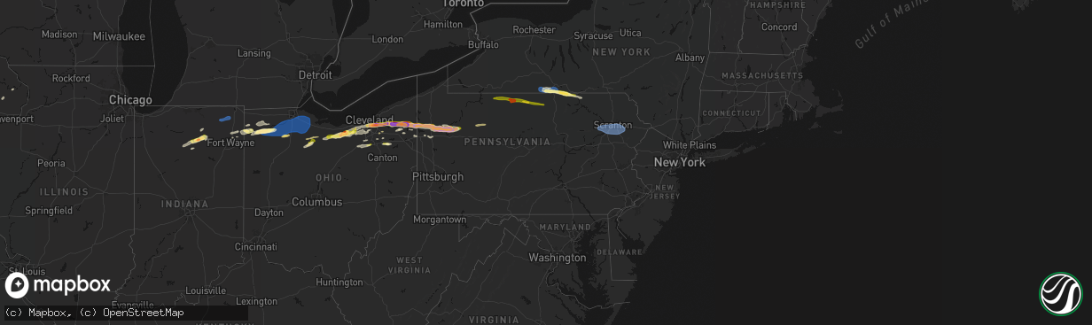
Hail
Wind
Tornado
19,025
Estimated number of impacted properties by a 1.00" hail or larger15,847
Estimated number of impacted properties by a 1.75" hail or larger0
Estimated number of impacted properties by a 2.50" hail or largerStorm reports in Pennsylvania
Pennsylvania
| Date | Description |
|---|---|
| 04/15/20266:45 PM CDT | Corrects previous hail report from 1 sw franklin. |
| 04/15/20266:19 PM CDT | Pine tree snapped. |
| 04/15/20266:15 PM CDT | A few trees downed across central erie county. |
| 04/15/20266:10 PM CDT | Tree downed and blocking road. Time estimated via radar. |
| 04/15/20266:10 PM CDT | A local report indicates 1.50 inch wind near 1 WNW Cranberry |
| 04/15/20266:10 PM CDT | A local report indicates 1.00 inch wind near 3 ESE Cranberry |
| 04/15/20266:06 PM CDT | A local report indicates 1.50 inch wind near 1 S Cranberry |
| 04/15/20265:45 PM CDT | A few reports of trees and wires down in sandy lake township. Time estimated from radar. |
| 04/15/20265:45 PM CDT | Hail size estimated from photo. |
| 04/15/20265:42 PM CDT | Report from mping: quarter |
| 04/15/20265:40 PM CDT | Several reports of trees and wires down. Time estimated from radar. |
| 04/15/20265:38 PM CDT | Report from mping: quarter |
| 04/15/20265:36 PM CDT | Report from mping: half dollar |
| 04/15/20265:34 PM CDT | Report from mping: quarter |
| 04/15/20265:30 PM CDT | Public shared a picture of ping pong ball size hail on social media. Time estimated based off radar. |
| 04/15/20265:22 PM CDT | Report from 511pa of tree down on w kidds mill rd near reynolds industrial park rd. Time estimated based off radar. |
| 04/15/20265:22 PM CDT | A local report indicates 1.00 inch wind near Greenville |
| 04/15/20265:22 PM CDT | Trees down. |
| 04/15/20265:15 PM CDT | Several reports of trees and wires down in west salem township. Time estimated from radar. |
| 04/15/20265:14 PM CDT | A local report indicates 1.75 inch wind near 2 NE Orangeville |
| 04/15/20265:14 PM CDT | A local report indicates 1.25 inch wind near 3 W Greenville |
| 04/15/20265:12 PM CDT | Trees and wires down near coryville. |
| 04/15/20264:51 PM CDT | Trees and wires down near custer city. |
| 04/15/20264:48 PM CDT | Trees and wires down near lewis run. |
| 04/14/202611:21 PM CDT | Wires down on springbrook road. |
| 04/14/202610:54 PM CDT | I-380 penndot exit 20 keystone mesonet maximum gust was 67 mph. |
| 04/14/202610:54 PM CDT | Tree down on roadway in moscow. |
| 04/14/202610:50 PM CDT | Corrects timing previous tstm wnd gst report from 1 nw fells corners. I-380 penndot exit 20 keystone mesonet maximum gust was 67 mph. |
| 04/14/202610:50 PM CDT | Padot station 11339 1 nw fells corners. |
| 04/14/202610:33 PM CDT | Tree down on main st. |
| 04/14/202610:30 PM CDT | Photos sent to nws with several uprooted softwood trees in backyard... North abingdon township. Radar-estimated time. |
| 04/14/202610:15 PM CDT | Multiple trees uprooted and snapped on private property. |
| 04/14/202610:06 PM CDT | Tree down on 1800 block of pa 42. |
| 04/14/20269:58 PM CDT | Tree down on roadway. |
| 04/14/20269:55 PM CDT | Tree down on dunwoody rd. |
| 04/14/20269:39 PM CDT | Roof off a house on 5900 block warrensville rd. |
| 04/14/20269:36 PM CDT | Large tree down blocking the roadway at beech valley rd and calvert rd. |
| 04/14/20268:12 PM CDT | Wires down on cars on redwood avenue. |
| 04/14/20267:56 PM CDT | Trees down on wires along beechwood road. |
| 04/14/20267:40 PM CDT | Tree down on wire... Which caught fire. Bradley road. Also at least pea-sized hail in the athens-milan area. Radar-estimated time. |
| 04/14/20267:12 PM CDT | Wires down on coryland road near church. Radar-estimated time. |
All States Impacted by Hail Map on April 15, 2026
Cities Impacted by Hail Map on April 15, 2026
- Genoa, NE
- Kingston, OK
- Monroe, NE
- Saybrook, IL
- Columbus, NE
- Bellwood, NE
- Schuyler, NE
- Leigh, NE
- David City, NE
- Rogers, NE
- Clarkson, NE
- Dodge, NE
- Howells, NE
- North Bend, NE
- Ames, NE
- Hooper, NE
- Scribner, NE
- Tekamah, NE
- Craig, NE
- Herman, NE
- Winslow, NE
- Nashoba, OK
- Little Sioux, IA
- Mondamin, IA
- Arlington, NE
- Pisgah, IA
- Logan, IA
- Woodbine, IA
- Moorhead, IA
- Dunlap, IA
- Dow City, IA
- Earling, IA
- Onawa, IA
- West Point, NE
- Denison, IA
- Arion, IA
- Defiance, IA
- Charter Oak, IA
- Ute, IA
- Soldier, IA
- Manilla, IA
- Westside, IA
- Vail, IA
- Deloit, IA
- Aspinwall, IA
- Manning, IA
- Arcadia, IA
- Breda, IA
- Kiron, IA
- Halbur, IA
- Carroll, IA
- Templeton, IA
- Hampton, NE
- Aurora, NE
- Giltner, NE
- Harvard, NE
- Irwin, IA
- Glidden, IA
- Henderson, NE
- Rochester, IN
- Kewanna, IN
- Scranton, IA
- Ralston, IA
- Churdan, IA
- Jefferson, IA
- Silver Lake, IN
- Claypool, IN
- Akron, IN
- Warsaw, IN
- Pierceton, IN
- Coon Rapids, IA
- Dedham, IA
- Waco, NE
- York, NE
- Mentone, IN
- Utica, NE
- Staplehurst, NE
- Gresham, NE
- Paton, IA
- Ulysses, NE
- Seward, NE
- Dwight, NE
- Bee, NE
- Winona Lake, IN
- Bradshaw, NE
- Roann, IN
- Macy, IN
- Brainard, NE
- Valparaiso, NE
- Dana, IA
- Weston, NE
- Rome City, IN
- Kendallville, IN
- Hudson, IN
- Corunna, IN
- Wolcottville, IN
- Stratford, IA
- Stanhope, IA
- North Manchester, IN
- Liberty Mills, IN
- Churubusco, IN
- Huntertown, IN
- Fort Wayne, IN
- Ashley, IN
- Pleasant Lake, IN
- Wahoo, NE
- Malmo, NE
- Ceresco, NE
- Boone, IA
- Ames, IA
- Story City, IA
- Gilbert, IA
- Jewell, IA
- Colon, NE
- Roland, IA
- Randall, IA
- Mark Center, OH
- Sherwood, OH
- Hicksville, OH
- Antwerp, OH
- Cecil, OH
- Mead, NE
- Graham, TX
- Grabill, IN
- Edgerton, OH
- Dewey, OK
- Bartlesville, OK
- Radcliffe, IA
- Alden, IA
- Ellsworth, IA
- Olney, TX
- Newcastle, TX
- Auburn, IN
- Leo, IN
- Spencerville, IN
- Blissfield, MI
- Riga, MI
- Ottawa Lake, MI
- Ida, MI
- Petersburg, MI
- Saint Joe, IN
- Harlan, IN
- McCallsburg, IA
- Yutan, NE
- Fremont, NE
- Valley, NE
- Defiance, OH
- Barnsdall, OK
- Ochelata, OK
- Ramona, OK
- Iowa Falls, IA
- Skiatook, OK
- Wann, OK
- New Haven, IN
- Copan, OK
- Holgate, OH
- Coffeyville, KS
- Dearing, KS
- Ackley, IA
- Aplington, IA
- Hominy, OK
- Archbold, OH
- Bryan, OH
- Stryker, OH
- Ney, OH
- Evansport, OH
- Napoleon, OH
- Liberty, KS
- Hubbard, IA
- Zearing, IA
- Independence, KS
- Cherryvale, KS
- Malinta, OH
- Dennis, KS
- Parsons, KS
- Galesburg, KS
- Thayer, KS
- Union, IA
- New Providence, IA
- Nowata, OK
- Austinville, IA
- Hamler, OH
- Conrad, IA
- Erie, KS
- Beaman, IA
- Stuart, IA
- Huxley, IA
- Cambridge, IA
- Merkel, TX
- Eldora, IA
- Whitten, IA
- Liscomb, IA
- Blair, NE
- Kennard, NE
- Slater, IA
- Delaware, OK
- Leipsic, OH
- Polk City, IA
- Parkersburg, IA
- Custar, OH
- Cygnet, OH
- Rudolph, OH
- Martin, OH
- Haskins, OH
- Dunbridge, OH
- Bowling Green, OH
- Pemberville, OH
- Woodville, OH
- Stony Ridge, OH
- New Bavaria, OH
- Bradner, OH
- Liberty Center, OH
- Risingsun, OH
- Walbridge, OH
- Gibsonburg, OH
- Wayne, OH
- Portage, OH
- Helena, OH
- Weston, OH
- Luckey, OH
- McClure, OH
- Tontogany, OH
- Elmore, OH
- Grelton, OH
- Deshler, OH
- Perrysburg, OH
- Genoa, OH
- Clay Center, OH
- Millbury, OH
- Waterville, OH
- Graytown, OH
- Milton Center, OH
- Grand Rapids, OH
- Chanute, KS
- Dexter, IA
- Missouri Valley, IA
- Lenapah, OK
- Grafton, OH
- North Ridgeville, OH
- Elyria, OH
- Lagrange, OH
- Columbia Station, OH
- Saint Paul, KS
- Hoytville, OH
- North Baltimore, OH
- Walnut, KS
- Pawnee, OK
- Fairfax, OK
- McComb, OH
- Pawhuska, OK
- Modale, IA
- Magnolia, IA
- Seymour, TX
- Wichita Falls, TX
- Holliday, TX
- Maxwell, IA
- Collins, IA
- Tiffin, OH
- Bloomville, OH
- Republic, OH
- Kansas, OH
- Rocky Ridge, OH
- Lindsey, OH
- Fremont, OH
- Fostoria, OH
- Burgoon, OH
- Oak Harbor, OH
- McCutchenville, OH
- Blockton, IA
- Bedford, IA
- Hawley, TX
- Elsmore, KS
- Stark, KS
- Savonburg, KS
- Olmsted Falls, OH
- Gladbrook, IA
- Prescott, IA
- Corning, IA
- Abilene, TX
- Anson, TX
- Wynona, OK
- Independence, OH
- Cleveland, OH
- State Center, IA
- Rhodes, IA
- Maple Heights, OH
- Bedford, OH
- Lueders, TX
- S Coffeyville, OK
- Diagonal, IA
- Edna, KS
- Brookpark, OH
- Okemah, OK
- Mapleton, KS
- Albany, TX
- Berea, OH
- North Royalton, OH
- Hudson, IA
- Welch, OK
- Shannon City, IA
- Traer, IA
- Creston, IA
- Greenfield, IA
- Reinbeck, IA
- Seminole, OK
- Moran, KS
- Orient, IA
- Wewoka, OK
- Solon, OH
- Chagrin Falls, OH
- Novelty, OH
- Bartlett, KS
- Chetopa, KS
- Oswego, KS
- Columbus, KS
- Winterset, IA
- Macksburg, IA
- Laurel, IA
- Marshalltown, IA
- Benton, IA
- Mount Ayr, IA
- Collins, OH
- Norwalk, OH
- Bascom, OH
- Buckingham, IA
- Waterloo, IA
- La Porte City, IA
- Stewartsville, MO
- Rea, MO
- King City, MO
- Guilford, MO
- Melbourne, IA
- Castle, OK
- Prescott, KS
- Mound City, KS
- Pleasanton, KS
- Lenox, IA
- Fulton, KS
- Clearfield, IA
- Urbandale, IA
- Grimes, IA
- Blue Mound, KS
- Brecksville, OH
- Kansas City, KS
- Shawnee, KS
- Kansas City, MO
- Riverside, MO
- Middlefield, OH
- Newbury, OH
- Burton, OH
- Hiram, OH
- Liberty, MO
- Kearney, MO
- Holt, MO
- Excelsior Springs, MO
- Lawson, MO
- Wellington, OH
- Oberlin, OH
- Monroeville, OH
- Wakeman, OH
- Willard, OH
- Kipton, OH
- Osawatomie, KS
- Garwin, IA
- Bellevue, OH
- Johnston, IA
- Greeley, KS
- Parker, KS
- Lane, KS
- Plattsburg, MO
- Osborn, MO
- Cameron, MO
- Maysville, MO
- Neodesha, KS
- Haverhill, IA
- Afton, IA
- Strongsville, OH
- Amsterdam, MO
- Garnett, KS
- New London, OH
- Steuben, WI
- Eastman, WI
- Stanberry, MO
- Tingley, IA
- Attica, OH
- Redding, IA
- Northfield, OH
- Le Grand, IA
- Montour, IA
- Jesup, IA
- Brandon, IA
- Van Meter, IA
- North Bloomfield, OH
- West Farmington, OH
- Waukee, IA
- West Des Moines, IA
- Ferguson, IA
- Gilman, IA
- Toledo, IA
- Leesburg, IN
- Polo, MO
- Kingston, MO
- Adrian, MO
- Grand River, IA
- Ellston, IA
- Paola, KS
- Weatherby, MO
- Winston, MO
- Wauzeka, WI
- Boscobel, WI
- Dyess Afb, TX
- Hume, MO
- Rich Hill, MO
- Henrietta, TX
- Garrettsville, OH
- Bristolville, OH
- Throckmorton, TX
- Woodson, TX
- Tye, TX
- Clive, IA
- Earlham, IA
- Gays Mills, WI
- Butler, MO
- North Fairfield, OH
- Greenwich, OH
- Des Moines, IA
- Pattonsburg, MO
- Fort Scott, KS
- Comanche, OK
- Tama, IA
- Clutier, IA
- Cortland, OH
- Farmdale, OH
- Uniontown, KS
- Bethany, MO
- Breckenridge, TX
- Murray, IA
- Osceola, IA
- Independence, IA
- Gilman City, MO
- Coffey, MO
- Weir, KS
- Galena, KS
- Pittsburg, KS
- Louisburg, KS
- Mingo, IA
- Bondurant, IA
- Asbury, MO
- Carl Junction, MO
- Scammon, KS
- Valley City, OH
- Bradford, PA
- Lewis Run, PA
- Harrisonville, MO
- Garden City, MO
- East Lynne, MO
- Pleasant Hill, MO
- Archie, MO
- Hepler, KS
- Redfield, KS
- Baxter, IA
- Spring Hill, KS
- Bucyrus, KS
- Kellerton, IA
- Greenville, PA
- Fowler, OH
- Kinsman, OH
- Burghill, OH
- Independence, MO
- Bloomington, WI
- Bagley, WI
- Patch Grove, WI
- Prairie Du Chien, WI
- Truro, IA
- New Virginia, IA
- Strasburg, MO
- Kingsville, MO
- Ridgeway, MO
- Cainsville, MO
- Richmond, MO
- Dysart, IA
- Masonville, IA
- Winthrop, IA
- Oronogo, MO
- Jasper, MO
- Aurora, IA
- Weldon, IA
- Norwalk, IA
- Prole, IA
- Webb City, MO
- Mount Hope, WI
- Brunswick, OH
- Broadview Heights, OH
- Hinckley, OH
- Sycamore, OH
- New Riegel, OH
- Elberon, IA
- Vinita, OK
- Aurora, OH
- Lamoni, IA
- Eagleville, MO
- Cumming, IA
- Lees Summit, MO
- Transfer, PA
- Port Allegany, PA
- Turtlepoint, PA
- Newton, IA
- Keystone, IA
- Garrison, IA
- Richfield, OH
- Peninsula, OH
- Carrollton, MO
- Dawn, MO
- Norborne, MO
- Braymer, MO
- Lone Jack, MO
- Loving, TX
- Medina, OH
- Huntsburg, OH
- Chardon, OH
- Saint Charles, IA
- Missouri City, MO
- Blythedale, MO
- Princeton, MO
- Trenton, MO
- Jamesport, MO
- Carthage, MO
- Golden City, MO
- Seville, OH
- Creston, OH
- Woodburn, IA
- Lucas, IA
- Manchester, IA
- Dundee, IA
- Lancaster, WI
- Woodman, WI
- Fennimore, WI
- Buckner, MO
- Olathe, KS
- Overland Park, KS
- Southington, OH
- Sterling, OH
- Westfield Center, OH
- Burbank, OH
- Smethport, PA
- Derby, IA
- Grain Valley, MO
- Oak Grove, MO
- Blue Springs, MO
- Sharpsville, PA
- Chariton, IA
- Wadsworth, OH
- Barberton, OH
- Gifford, PA
- Roulette, PA
- Shinglehouse, PA
- Eldred, PA
- Coudersport, PA
- Stitzer, WI
- Grinnell, IA
- Rittman, OH
- Humeston, IA
- Hudson, OH
- Montrose, MO
- Bogard, MO
- Hadley, PA
- Stoneboro, PA
- Clarks Mills, PA
- Fredonia, PA
- Vinton, IA
- Rayville, MO
- Lathrop, MO
- Streetsboro, OH
- Sibley, MO
- Ryan, OK
- Van Horne, IA
- Windsor, OH
- Lamar, MO
- Van Wert, IA
- Mercer, PA
- Warren, OH
- Cuyahoga Falls, OH
- Jackson Center, PA
- Urbana, IA
- Center Point, IA
- Doylestown, OH
- Williamson, IA
- Martinsville, MO
- Lineville, IA
- Mercer, MO
- Sandy Lake, PA
- Polk, PA
- Franklin, PA
- Russell, IA
- Coggon, IA
- New Hampton, MO
- Terral, OK
- Archer City, TX
- Scotland, TX
- Mantua, OH
- Livingston, WI
- Bryson, TX
- Moran, TX
- Windham, OH
- Leawood, KS
- Miami, OK
- Malcom, IA
- Chelsea, IA
- Genesee, PA
- Turney, MO
- Tina, MO
- Hale, MO
- Ulysses, PA
- Munroe Falls, OH
- Amoret, MO
- Cowgill, MO
- Orrick, MO
- Mogadore, OH
- Stilwell, KS
- Atwater, OH
- Rootstown, OH
- Clinton, MO
- Emlenton, PA
- Kennerdell, PA
- Cranberry, PA
- Seneca, PA
- Chillicothe, MO
- Corydon, IA
- Baxter Springs, KS
- San Angelo, TX
- Ardmore, OK
- Ryan, IA
- Melrose, IA
- Lovilia, IA
- Ringling, OK
- Belle Plaine, IA
- Jacksboro, TX
- Central City, IA
- Galeton, PA
- Luzerne, IA
- Walker, IA
- Kent, OH
- Lacona, IA
- Gaines, PA
- Westfield, PA
- Sabinsville, PA
- Foster, MO
- La Cygne, KS
- Drexel, MO
- Kossuth, PA
- Shippenville, PA
- Venus, PA
- Fryburg, PA
- Lucinda, PA
- Marble, PA
- Kidder, MO
- Gallatin, MO
- Jameson, MO
- Burbank, OK
- Riverton, KS
- Hamlin, IA
- Audubon, IA
- Exira, IA
- Hamilton, MO
- Windthorst, TX
- Melcher Dallas, IA
- Knox, PA
- Perkins, OK
- Hopkinton, IA
- Coyle, OK
- Stillwater, OK
- Delhi, IA
- Meadville, MO
- Blairstown, IA
- Vienna, OH
- Stockton, IL
- Lena, IL
- Lexington, NE
- Greeley, CO
- Maxwell, NE
- Amherst, NE
- New Raymer, CO
- Thurman, IA
- Beaver Crossing, NE
- Moorefield, NE
- Cozad, NE
- Kearney, NE
- Pleasant Dale, NE
- Garden Grove, IA
- Red Oak, IA
- Stoneham, CO
- Sterling, CO
- Weeping Water, NE
- Hamilton, CO
- Brady, NE
- Galeton, CO
- Fairview, UT
- Fort Collins, CO
- Fleming, CO
- Venango, NE
- Helper, UT
- Glen Haven, CO
- Timnath, CO
- Lincoln, NE
- Waverly, NE
- Randolph, IA
- Elmwood, NE
- Merino, CO
- Holyoke, CO
- Dickens, NE
- Sidney, IA
- Meeker, CO
- Plattsmouth, NE
- Nephi, UT
- Farnam, NE
- Alvo, NE
- Wallace, NE
- Ely, NV
- Kremmling, CO
- Clarinda, IA
- Nehawka, NE
- Malcolm, NE
- Gravity, IA
- Millerton, IA
- Gill, CO
- Windsor, CO
- Imogene, IA
- Elsie, NE
- Estes Park, CO
- Riverdale, NE
- Doniphan, NE
- Loveland, CO
- Murdock, NE
- Phillips, NE
- Tabor, IA
- Amherst, CO
- Madrid, NE
- Oak Creek, CO
- Overton, NE
- Steamboat Springs, CO
- Briggsdale, CO
- Rangely, CO
- Gibbon, NE
- Nodaway, IA
- Eaton, CO
- Duchesne, UT
- Wellfleet, NE
- Maywood, NE
- Grand Island, NE
- Vernal, UT
- Haxtun, CO
- Wood River, NE
- Essex, IA
- Alda, NE
- Milford, NE
- Elm Creek, NE
- Villisca, IA
- Curtis, NE
- Union, NE
- Eagle, NE
- Grant, NE
- Hayden, CO
- Murray, NE
- Shelton, NE
- Drake, CO
- Wellsboro, PA
- Lone Grove, OK
- Miles, TX
- Woodhull, NY
- Addison, NY
- Overbrook, OK
- Graford, TX
- Mound Valley, KS
- Altamont, KS
- West Middlesex, PA
- Hubbard, OH
- Masury, OH
- Mystic, IA
- Tishomingo, OK
- Wilson, OK
- Allerton, IA
- Promise City, IA
- Purcell, MO
- Alba, MO
- Bronte, TX
- Albia, IA
- Moravia, IA
- Milburn, OK
- Stonewall, OK
- Marengo, IA
- Lowry City, MO
- Osceola, MO
- Brookfield, OH
- Laclede, MO
- Ringgold, TX
- Rowena, TX
- Strawn, TX
- Galt, MO
- Perrin, TX
- Dumont, IA
- Geneva, IA
- Sunset, TX
- Sulphur, OK
- Mill Creek, OK
- Mannsville, OK
- Tupelo, OK
- Lawrenceville, PA
- Lindley, NY
- Guthrie Center, IA
- Lucerne, MO
- Painted Post, NY
- Nocona, TX
- Winslow, IL
- Ballinger, TX
- Fairfax, IA
- Walford, IA
- Norway, IA
- Laredo, MO
- Hedrick, IA
- Pine City, NY
- Corning, NY
- Millerton, PA
- Clarington, PA
- Sigel, PA
- Unionville, MO
- Powersville, MO
- Bowie, TX
- Chico, TX
- Bridgeport, TX
- Alvord, TX
- Gillett, PA
- Wellston, OK
- Forestburg, TX
- Linneus, MO
- Bayard, IA
- Washington, IA
- Hampton, IA
- Cedar Rapids, IA
- Havana, KS
- Caney, KS
- Grove City, PA
- Centerville, IA
- Seymour, IA
- Cincinnati, IA
- Sigourney, IA
- Ollie, IA
- West Mineral, KS
- McCune, KS
- Hayesville, IA
- Paint Rock, TX
- Wellsburg, NY
- Wapanucka, OK
- Ridgway, PA
- Grand Junction, IA
- Keota, IA
- West Chester, IA
- Panora, IA
- Bagley, IA
- Ainsworth, IA
- Columbia Cross Roads, PA
- Tyro, KS
- Oil City, PA
- Rosston, TX
- Pollock, MO
- Coalgate, OK
- Athens, PA
- Sayre, PA
- Cherokee, KS
- Riverside, IA
- Coleman, OK
- Moulton, IA
- Udell, IA
- Exline, IA
- Linn Creek, MO
- Yale, IA
- Muenster, TX
- Decatur, TX
- Montreal, MO
- Gainesville, TX
- Atlanta, MO
- Milan, PA
- Janesville, WI
- Lindsay, TX
- Wellman, IA
- Camdenton, MO
- Letts, IA
- Ulster, PA
- Lanark, IL
- Mount Carroll, IL
- Dawson, IA
- Perry, IA
- Cuba, MO
- Rosebud, MO
- Sullivan, MO
- Owensville, MO
- Opolis, KS
- Columbus Junction, IA
- Lone Tree, IA
- Conesville, IA
- Valley View, TX
- Preston, IA
- Maquoketa, IA
- Mertzon, TX
- Kahoka, MO
- Nichols, IA
- Milton, WI
- Madill, OK
- Grand Mound, IA
- Wheatland, IA
- Lost Nation, IA
- West Branch, IA
- Iowa City, IA
- Whitt, TX
- Thackerville, OK
- Marietta, OK
- Whitesboro, TX
- Era, TX
- Centrahoma, OK
- Shidler, OK
- Elkhorn, WI
- Pecatonica, IL
- German Valley, IL
- Leaf River, IL
- Ridott, IL
- Gordonville, TX
- Madrid, IA
- Lohrville, IA
- Thomson, IL
- Savanna, IL
- Bouton, IA
- Sanger, TX
- Gerald, MO
- Beaufort, MO
- Leslie, MO
- Lebanon, MO
- Farnhamville, IA
- Saint Patrick, MO
- Jamaica, IA
- Dallas Center, IA
- Muscatine, IA
- Pottsboro, TX
- Gowrie, IA
- Woodward, IA
- Adel, IA
- Alexandria, MO
- Wayland, MO
- Kenefic, OK
- Lewistown, MO
- Ewing, MO
- La Belle, MO
- Winnebago, IL
- Lane, OK
- Stringtown, OK
- Prairie Village, KS
- Pilot Point, TX
- Collinsville, TX
- North Prairie, WI
- Mukwonago, WI
- Waukesha, WI
- Eagle, WI
- Granger, IA
- Illinois City, IL
- Nevada, IA
- Hales Corners, WI
- Milwaukee, WI
- New Berlin, WI
- Muskego, WI
- Big Bend, WI
- Sheldahl, IA
- Kelley, IA
- Rockford, IL
- Keokuk, IA
- Vienna, MO
- Dixon, MO
- Monticello, MO
- La Grange, MO
- Denison, TX
- Bells, TX
- Shannon, IL
- Tioga, TX
- Durand, IL
- Wales, WI
- Saint James, MO
- Rolla, MO
- Vichy, MO
- Poplar Grove, IL
- Capron, IL
- Belle, MO
- Bland, MO
- Canton, MO
- Ravenna, TX
- Colo, IA
- Harcourt, IA
- Dayton, IA
- Boxholm, IA
- Ogden, IA
- Pilot Mound, IA
- Burnside, IA
- Lehigh, IA
- Fort Dodge, IA
- Andes, NY
- Margaretville, NY
- Warsaw, IL
- Hamilton, IL
- Hendrix, OK
- Callender, IA
- Talihina, OK
- Clayton, OK
- Sherman, TX
- Roscoe, NY
- Howe, TX
- Fleischmanns, NY
- Pine Hill, NY
- Big Indian, NY
- Arkville, NY
- Ponca City, OK
- Bangs, TX
- Santa Anna, TX
- Mindenmines, MO
- Neck City, MO
- Liberal, MO
- Savoy, TX
- Brownwood, TX
- Clemons, IA
- Tonkawa, OK
- Quapaw, OK
- Charleston, AR
- Lavaca, AR
- Greenwood, AR
- Hackett, AR
- Booneville, AR
- Fort Smith, AR
- Early, TX
- Grundy Center, IA
- Albion, IA
- Lincoln, IA
- High Falls, NY
- Stone Ridge, NY
- Accord, NY
- Zephyr, TX
- Blanket, TX
- Cottekill, NY
- Unityville, PA
- Comanche, TX
- Ozark, AR
- Scranton, AR
- Subiaco, AR
- Paris, AR
- Magazine, AR
- Ratcliff, AR
- Branch, AR
- New Blaine, AR
- Delaware, AR
- Havana, AR
- Belleville, AR
- Danville, AR
- Dardanelle, AR
- Blue Mountain, AR
- Russellville, AR
- Lamar, AR
- London, AR
- Knoxville, AR
- Ola, AR
- Clarksville, AR
- Hartman, AR
- Dover, AR
- Hagarville, AR
- Hector, AR
- Pelsor, AR
- Pottsville, AR
- Atkins, AR
- Gustine, TX
- Talala, OK
- Carlton, TX
- Hico, TX
- Chelsea, OK
- Hattieville, AR
- Jerusalem, AR
- Cleveland, AR
- Bates City, MO
- Odessa, MO
- Holden, MO
- Bourbon, MO
- Leasburg, MO
- Wyoming, PA
- Shavertown, PA
- Luzerne, PA
- Pittston, PA
- Kingston, PA
- Dallas, PA
- Clarks Summit, PA
- Wilkes Barre, PA
- Moscow, PA
- Old Forge, PA
- Scranton, PA
- Taylor, PA
- Duryea, PA
- Moosic, PA
- Gouldsboro, PA
- Lake Ariel, PA
- Newfoundland, PA
- Sterling, PA
- New Wilmington, PA
- Wheatland, PA
- Hermitage, PA
- Girard, OH
- Belton, MO
- Leon, IA
- Davis City, IA
- Muncy, PA
- Trout Run, PA
- Muncy Valley, PA
- Benton, PA
- Williamsport, PA
- Montoursville, PA
- Hughesville, PA
- Cogan Station, PA
- Garden City, IA
- Clark, PA
- Elburn, IL
- Maple Park, IL
- Sugar Grove, IL
- Geneva, IL
- Eddyville, IA
- Cedar, IA
- Oskaloosa, IA
- Fremont, IA
- Delta, IA
- Eldridge, MO
- Lockwood, MO
- Joplin, MO
- Carterville, MO
- Golden, IL
- Machias, NY


