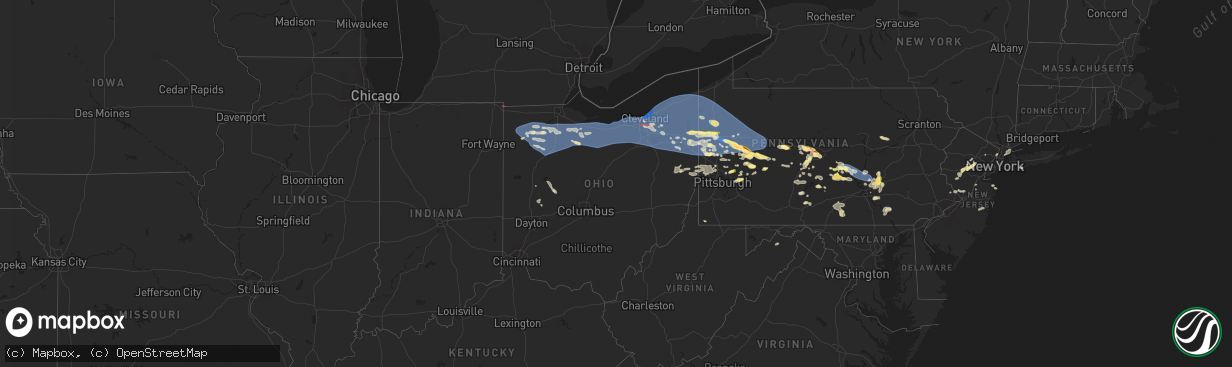
Hail Map in Ohio on August 6, 2024
The weather event in Ohio on August 6, 2024 includes Wind, Tornado, and Hail maps. 17 states and 839 cities were impacted and suffered possible damage. The total estimated number of properties impacted is 819.
Wind
Tornado
Hail
819
Estimated number of impacted properties by a 1.00" hail or larger0
Estimated number of impacted properties by a 1.75" hail or larger0
Estimated number of impacted properties by a 2.50" hail or largerStorm reports in Ohio
Ohio
| Date | Description |
|---|---|
| 08/06/20246:15 PM CDT | Trees reported down in middleburg. Time estimated from radar. |
| 08/06/20246:04 PM CDT | Pole down on e. Mason road and 29 intersection. Time estimated from radar. |
| 08/06/20246:02 PM CDT | Corrects previous tstm wnd dmg report from bellefontaine. Reports of numerous trees down throughout bellefontaine. Time estimated from radar. |
| 08/06/20245:55 PM CDT | Poles down on amsterdam road and mccartyville and wells road intersection. Time estimated from radar. |
| 08/06/20245:48 PM CDT | Reports of numerous trees down throughout bellefontaine. Time estimated from radar. |
| 08/06/20244:54 PM CDT | Several reports of trees and wires down in beaver township. Time estimated via radar. |
| 08/06/20244:38 PM CDT | Tree and power lines down on beechwood rd |
| 08/06/20244:37 PM CDT | Fire department and the public reported numerous trees down in the green township area... Including along lisbon road and roller road south of the town center... And al |
| 08/06/20244:27 PM CDT | Several trees downed along stanhope-kelloggsville in williamsfield twp between us 322 and us 6. Flooding also noted. Time estimated via radar. |
| 08/06/20244:24 PM CDT | Numerous trees down in gustavus. |
| 08/06/20244:23 PM CDT | Trees downed just south of the mahoning/trumbull county border along the mahoning river. |
| 08/06/20244:20 PM CDT | Emergency manager reported limbs down on several roadways across the area with approximately 2000 customers without power in the county. The em noted the winds occurred |
| 08/06/20244:19 PM CDT | Report from mping: trees uprooted or snapped;. |
| 08/06/20244:19 PM CDT | Report from mping: trees uprooted or snapped;. |
| 08/06/20244:14 PM CDT | Large branches down in alliance area... Including northside rd ne and spruce drive ne in addition to mccallum ave ne. Time estimated via radar. |
| 08/06/20244:11 PM CDT | Tree down on house. Time estimated from radar. |
| 08/06/20244:11 PM CDT | Numerous trees down. |
| 08/06/20244:10 PM CDT | Report from mping: trees uprooted or snapped;. |
| 08/06/20244:06 PM CDT | Report from mping: trees uprooted or snapped;. |
| 08/06/20244:06 PM CDT | Report from mping: 3-inch tree limbs broken; power poles broken. |
| 08/06/20243:59 PM CDT | Roof damage to communications center with windows and doors also blown out. |
| 08/06/20243:57 PM CDT | Large tree uprooted - time estimated via radar. |
| 08/06/20243:57 PM CDT | Numerous large tree limbs down. |
| 08/06/20243:57 PM CDT | Multiple trees down on n river rd between 45 and 82. |
| 08/06/20243:57 PM CDT | Tree on car and several other trees snapped off. |
| 08/06/20243:56 PM CDT | Corrects previous non-tstm wnd gst report from 2 wnw lakemore. Awos station kakr 2 wnw lakemore. |
| 08/06/20243:55 PM CDT | Several trees down in camping area... Including trees down on multiple campers. Time estimated via radar. |
| 08/06/20243:53 PM CDT | Tree down and several wires down in ellet akron. |
| 08/06/20243:52 PM CDT | Numerous reports of trees down along state route 14 in and around ravenna. Time estimated via radar. |
| 08/06/20243:50 PM CDT | Tree down on fence. |
| 08/06/20243:50 PM CDT | Numerous downed trees - time estimated via radar. |
| 08/06/20243:46 PM CDT | Large tree down on state road. |
| 08/06/20243:46 PM CDT | Multiple trees down on golf course. Time estimated via radar. |
| 08/06/20243:44 PM CDT | Several trees and wires west and southwest of akron. |
| 08/06/20243:42 PM CDT | Large tree limbs down in akron. |
| 08/06/20243:42 PM CDT | Several trees and wires down on the north side of akron. |
| 08/06/20243:40 PM CDT | Large tree limb down - time estimated via radar. |
| 08/06/20243:39 PM CDT | 15 inch tree branch from healthy tree snapped off onto power lines. |
| 08/06/20243:37 PM CDT | Numerous trees... Poles and wires down. |
| 08/06/20243:36 PM CDT | Corrects previous non-tstm wnd gst report from 1 nnw fairport harbor. Buoy station faio1 fairport... Oh. |
| 08/06/20243:35 PM CDT | Large tree snapped in half. Radar time estimate. Hodgson rd... Mentor... Oh. |
| 08/06/20243:35 PM CDT | Large branches tree branches down. |
| 08/06/20243:35 PM CDT | Report from mping: 3-inch tree limbs broken; power poles broken. |
| 08/06/20243:35 PM CDT | Multiple trees down on road and powerline. Radar estimated time. Ferry road in chesterland... Oh. |
| 08/06/20243:33 PM CDT | Large tree and limbs down over a road. |
| 08/06/20243:33 PM CDT | Large branches and powerlines down. Sutherland ct... Mentor... Oh. Radar estimated time. |
| 08/06/20243:33 PM CDT | Report from mping: trees uprooted or snapped;. |
| 08/06/20243:33 PM CDT | Small to medium sized trees down. |
| 08/06/20243:32 PM CDT | Large trees down in chesterland. |
| 08/06/20243:32 PM CDT | Estimated 70-80 mph wind gust. |
| 08/06/20243:31 PM CDT | Tree downed along route 61 at lauretta ave near the ashland golf club. Time estimated via radar. |
| 08/06/20243:30 PM CDT | Buoy station faio1 fairport... Oh. |
| 08/06/20243:30 PM CDT | Large tree down in road. |
| 08/06/20243:30 PM CDT | Multiple downed trees - time estimated via radar. |
| 08/06/20243:30 PM CDT | Two trees down on arthur rd. |
| 08/06/20243:30 PM CDT | Large 6-inch diameter tree branches broke/snapped. |
| 08/06/20243:30 PM CDT | Large tree branch down. |
| 08/06/20243:29 PM CDT | Estimated 60 mph winds... Trees and wires down across lake county. |
| 08/06/20243:26 PM CDT | Estimated 6 inch diameter branches down. Time estimated via radar. |
| 08/06/20243:24 PM CDT | Trees and large branches down in neighborbood east of the easterly wwtp. |
| 08/06/20243:24 PM CDT | Willoughby hills fd reports they lost the roof off of their station. |
| 08/06/20243:23 PM CDT | A swath of several snapped healthy trees along the buckeye trail north of blue hen falls. Possible tornado damage as location matches with tds on radar. |
| 08/06/20243:23 PM CDT | 10 to 15 homes were damaged by downed trees east of the bedford reservation. Time of the event was estimated by radar. |
| 08/06/20243:22 PM CDT | Tree limbs down and metal bleacher wall substantially bent. |
| 08/06/20243:21 PM CDT | Numerous trees down and some equipment damaged at wastewater treatment plant. Roof damage to apartment building on south side of lakeshore blvd. |
| 08/06/20243:20 PM CDT | Multiple large limbs and several trees down. |
| 08/06/20243:19 PM CDT | Several large trees and powerlines down in eastlake. |
| 08/06/20243:19 PM CDT | Asos station kbkl cleveland. |
| 08/06/20243:17 PM CDT | Large tree branch down - time estimated via radar. |
| 08/06/20243:17 PM CDT | Multiple large trees and large branches down. |
| 08/06/20243:17 PM CDT | Marathon fuel pump roof lifted and structure damaged. Radar estimated time. 100 n vance st... Carey... Oh 43316. |
| 08/06/20243:16 PM CDT | Report from mping: trees uprooted or snapped;. |
| 08/06/20243:16 PM CDT | Large tree snapped in half - time estimated via radar. |
| 08/06/20243:16 PM CDT | Multiple large roof tiles removed and debris scattered. Large portion of the roof appears to have fallen off. |
| 08/06/20243:15 PM CDT | 40-50 foot tall tree uprooted with several other large branches down nearby. |
| 08/06/20243:13 PM CDT | Several tree limbs down. |
| 08/06/20243:13 PM CDT | Asos station kcle cleveland. |
| 08/06/20243:13 PM CDT | Trees down in the 800 block of county road 500 in northern ashland county. Time estimated via radar. |
| 08/06/20243:13 PM CDT | Healthy tree down. |
| 08/06/20243:10 PM CDT | Asos station kbkl cleveland. |
| 08/06/20243:08 PM CDT | Several trees down on chestnut rd with at least one tree on a home. |
| 08/06/20243:07 PM CDT | Numerous large tree limbs and large tree down. One tree snapped in half. |
| 08/06/20243:07 PM CDT | Structural damage to a roof. Multiple large trees down. |
| 08/06/20243:05 PM CDT | Numerous powerlines and poles down. |
| 08/06/20243:04 PM CDT | Numerous large tree limbs snapped off in parma heights near fernhurst avenue and rosslyn. |
| 08/06/20243:04 PM CDT | Several tree limbs blown down onto power lines. |
| 08/06/20243:03 PM CDT | Multiple large trees snapped in half. Numerous limbs down. |
| 08/06/20243:03 PM CDT | Large tree down across roadway at w. 152 & lorain ave. |
| 08/06/20243:03 PM CDT | Numerous tree limbs down in lakewood. |
| 08/06/20243:03 PM CDT | Powerline pole and wires down. |
| 08/06/20243:03 PM CDT | Numerous large trees down. At least one tree uprooted. |
| 08/06/20243:03 PM CDT | Large tree snapped in half... Fallen on powerlines. |
| 08/06/20243:03 PM CDT | House with roof partially removed... Detached garage collapsed. |
| 08/06/20243:03 PM CDT | Pine tree and large limbs from smaller tree down. |
| 08/06/20243:02 PM CDT | Numerous power poles downed on 130th street in parma. Several large trees limbs downed. |
| 08/06/20243:02 PM CDT | Asos station klpr lorain elyria. |
| 08/06/20243:00 PM CDT | 18 inch tree down. |
| 08/06/20243:00 PM CDT | Report from mping: trees uprooted or snapped;. |
| 08/06/20242:59 PM CDT | Tornado touched down in brook park... Tracked east across southern cuyahoga county... And lifted in bedford. The tornado max wind speed was 104 mph and 350 yards wide. |
| 08/06/20242:58 PM CDT | Multiple 3-4 inch diameter tree branches down by i-90 and detroit rd. |
| 08/06/20242:58 PM CDT | Several trees and wires down in se part of brookpark. Some telephone poles down across roads. |
| 08/06/20242:56 PM CDT | Large tree down on roof of house. Laurel ave in rocky river... Oh. Radar estimated time. |
| 08/06/20242:55 PM CDT | Tree down on a porch. |
| 08/06/20242:54 PM CDT | Telephone poles down. |
| 08/06/20242:54 PM CDT | Plastic shed blown apart... 6 inch tree down on wires. |
| 08/06/20242:54 PM CDT | Large tree down on clague road between i-480 and lorain road. |
| 08/06/20242:51 PM CDT | 9 inch tree down east of sterns road and lorain road. |
| 08/06/20242:51 PM CDT | Numerous tree limbs down and some trees debarked. |
| 08/06/20242:51 PM CDT | Large trees down at dover center and cottonwood trail and on ashbury park dr. |
| 08/06/20242:51 PM CDT | Several large tree limbs down. |
| 08/06/20242:50 PM CDT | Tree limbs downed onto garage - time estimated via radar. |
| 08/06/20242:50 PM CDT | Numerous reports of trees down throughout the county. |
| 08/06/20242:47 PM CDT | Large tree downed - time estimated via radar. |
| 08/06/20242:47 PM CDT | Large tree fallen on house. |
| 08/06/20242:46 PM CDT | Multiple large limbs down. |
| 08/06/20242:45 PM CDT | A tornado began across extreme northeast lorain county and tracked east into cuyahoga county. Multiple trees snapped... Trampoline tossed... And removed shingles from a |
| 08/06/20242:43 PM CDT | Large tree limbs downed onto cars. |
| 08/06/20242:43 PM CDT | 8 inch tree down. |
| 08/06/20242:42 PM CDT | Several trees and power lines downed across eastern portions of putnam county. 10-13 power lines down on county road 7 north of us 224. Trees blocking road on county ro |
| 08/06/20242:41 PM CDT | Large tree down along with several power lines. |
| 08/06/20242:40 PM CDT | Tree damage throughout the city of sheffield lake. |
| 08/06/20242:36 PM CDT | County em reported 20 to 30 trees downed in and around oakwood park. |
| 08/06/20242:35 PM CDT | Numerous trees and limbs down south of lorain. |
| 08/06/20242:33 PM CDT | Gazebo thrown into pool and tangled in powerlines - time estimated via radar. |
| 08/06/20242:33 PM CDT | Tree down on house - time estimated via radar. |
| 08/06/20242:31 PM CDT | Report from mping: 3-inch tree limbs broken; power poles broken. |
| 08/06/20242:20 PM CDT | Power lines downed. |
| 08/06/20242:02 PM CDT | Several trees down. Time estimated from radar. |
| 08/06/20241:53 PM CDT | Asos station kdfi defiance. |
| 08/06/20241:50 PM CDT | Large tree limbs down at county roads 11c and n. Time estimated from radar. |
| 08/06/20241:31 PM CDT | A 20 foot tree was down in okolona. Time estimated from radar. |
| 08/06/20241:02 PM CDT | Multiple trees down between struthers and lowellville. Time estimated from radar. |
| 08/06/202411:56 AM CDT | Tree on utility wires. Time estimated from radar. |
| 08/06/20249:17 AM CDT | Tree damage near intersection of county road 11 and road s. |
| 08/06/20249:16 AM CDT | Trees down in the area. |
All States Impacted by Hail Map on August 6, 2024
Cities Impacted by Hail Map on August 6, 2024
- Lawton, MI
- Marcellus, MI
- Decatur, MI
- Schoolcraft, MI
- Mendon, MI
- Three Rivers, MI
- Centreville, MI
- Sturgis, MI
- Bronson, MI
- Coldwater, MI
- Edon, OH
- West Unity, OH
- Archbold, OH
- Fayette, OH
- Mercer, PA
- Sharpsville, PA
- Hermitage, PA
- Sharon, PA
- Grove City, PA
- Boyers, PA
- Harrisville, PA
- Hilliards, PA
- Parker, PA
- Bruin, PA
- Petrolia, PA
- West Middlesex, PA
- Pulaski, PA
- New Wilmington, PA
- Karns City, PA
- East Brady, PA
- Rimersburg, PA
- Edinburg, PA
- New Castle, PA
- Volant, PA
- Templeton, PA
- New Bethlehem, PA
- Cowansville, PA
- Slippery Rock, PA
- Seminole, PA
- Adrian, PA
- Masury, OH
- Campbell, OH
- Lowellville, OH
- Youngstown, OH
- Dayton, PA
- Kittanning, PA
- Hartstown, PA
- Jamestown, PA
- Adamsville, PA
- West Sunbury, PA
- Butler, PA
- Portersville, PA
- Girard, OH
- Mineral Ridge, OH
- McDonald, OH
- Butler, IN
- Wampum, PA
- New Galilee, PA
- Ellwood City, PA
- Cochranton, PA
- Harmony, PA
- Smicksburg, PA
- Hadley, PA
- Clarks Mills, PA
- Stoneboro, PA
- Sandy Lake, PA
- Luthersburg, PA
- Sheakleyville, PA
- Edgerton, OH
- Bryan, OH
- Canfield, OH
- Marion Center, PA
- Rochester Mills, PA
- Grampian, PA
- Curwensville, PA
- Rockton, PA
- Prospect, PA
- Struthers, OH
- Home, PA
- Clearfield, PA
- Knox, PA
- Defiance, OH
- Ney, OH
- Ford City, PA
- Punxsutawney, PA
- Northpoint, PA
- Shelocta, PA
- Elderton, PA
- Rural Valley, PA
- Creekside, PA
- Indiana, PA
- Clymer, PA
- Morrisdale, PA
- Woodland, PA
- Mark Center, OH
- Sherwood, OH
- Pittsburgh, PA
- Renfrew, PA
- Napoleon, OH
- Hicksville, OH
- Salineville, OH
- Rossiter, PA
- Glen Campbell, PA
- Weston, OH
- Custar, OH
- Kylertown, PA
- Winburne, PA
- Lanse, PA
- Drifting, PA
- Grassflat, PA
- Philipsburg, PA
- Munson, PA
- Wellsville, OH
- Russellton, PA
- Cheswick, PA
- Creighton, PA
- Tarentum, PA
- Tyrone, PA
- Vandergrift, PA
- Penn Run, PA
- Apollo, PA
- Holgate, OH
- Deshler, OH
- McClure, OH
- Worthington, PA
- Cherry Tree, PA
- Allport, PA
- Warriors Mark, PA
- Hamler, OH
- Allison Park, PA
- Rudolph, OH
- Cabot, PA
- Moshannon, PA
- Murrysville, PA
- Export, PA
- Saltsburg, PA
- Malinta, OH
- Coalport, PA
- North Apollo, PA
- East Vandergrift, PA
- Bowling Green, OH
- Portage, OH
- Port Matilda, PA
- Brackenridge, PA
- Natrona Heights, PA
- West Decatur, PA
- Oakwood, OH
- Sarver, PA
- Grand Rapids, OH
- Snow Shoe, PA
- Julian, PA
- Fleming, PA
- Bellefonte, PA
- Beccaria, PA
- Freeport, PA
- Gibsonburg, OH
- Helena, OH
- Bradner, OH
- Cygnet, OH
- Wayne, OH
- Hawk Run, PA
- Osceola Mills, PA
- Willow Street, PA
- Lancaster, PA
- Patton, PA
- Fallentimber, PA
- Flinton, PA
- Lawrence Township, NJ
- Princeton Junction, NJ
- Washington Crossing, PA
- Trenton, NJ
- Morrisville, PA
- Fair Haven, NJ
- Atlantic Highlands, NJ
- Red Bank, NJ
- Rumson, NJ
- Jerry City, OH
- New Bavaria, OH
- Milton Center, OH
- Grelton, OH
- Pemberville, OH
- Leipsic, OH
- Avonmore, PA
- Cranberry Township, PA
- Fremont, OH
- Monmouth Beach, NJ
- Saxonburg, PA
- Evans City, PA
- Connoquenessing, PA
- Burgoon, OH
- Aliquippa, PA
- State College, PA
- Clune, PA
- McIntyre, PA
- Clarksburg, PA
- Slickville, PA
- Bloomdale, OH
- Bellevue, OH
- Green Springs, OH
- Clyde, OH
- Freedom, PA
- Conway, PA
- Ambridge, PA
- Conestoga, PA
- Millersville, PA
- Copiague, NY
- Amityville, NY
- Lindenhurst, NY
- Liberty Center, OH
- Cecil, OH
- McComb, OH
- Findlay, OH
- Arcadia, OH
- Fostoria, OH
- Van Buren, OH
- North Baltimore, OH
- Hoytville, OH
- Bascom, OH
- Tiffin, OH
- Kansas, OH
- Republic, OH
- Risingsun, OH
- Old Fort, OH
- West Millgrove, OH
- Bettsville, OH
- Lindsey, OH
- Vickery, OH
- Sandusky, OH
- Castalia, OH
- Monroeville, OH
- Milan, OH
- Huron, OH
- Norwalk, OH
- Vermilion, OH
- Lorain, OH
- Berlin Heights, OH
- Willard, OH
- Amherst, OH
- Greenwich, OH
- New London, OH
- Oberlin, OH
- Wakeman, OH
- Wellington, OH
- Kipton, OH
- Attica, OH
- Collins, OH
- North Fairfield, OH
- Elyria, OH
- Avon Lake, OH
- Avon, OH
- Sheffield Lake, OH
- Olmsted Falls, OH
- Cleveland, OH
- Grafton, OH
- Lagrange, OH
- Lakewood, OH
- North Ridgeville, OH
- Columbia Station, OH
- Brookpark, OH
- Westlake, OH
- Bay Village, OH
- Rocky River, OH
- Berea, OH
- North Olmsted, OH
- Spencer, OH
- Valley City, OH
- Medina, OH
- Brunswick, OH
- Litchfield, OH
- Strongsville, OH
- Altoona, PA
- Monroe Township, NJ
- Baden, PA
- Wexford, PA
- Sewickley, PA
- Washington Boro, PA
- Hollidaysburg, PA
- Long Branch, NJ
- Newtown, PA
- New Riegel, OH
- Englishtown, NJ
- Felton, PA
- Brogue, PA
- Alexandria, PA
- Sedona, AZ
- Millville, PA
- Ottawa, OH
- Titusville, NJ
- Independence, OH
- Maple Heights, OH
- Bedford, OH
- Pennsylvania Furnace, PA
- Milroy, PA
- Lewistown, PA
- McClure, PA
- Williamsburg, PA
- Bellwood, PA
- Orangeville, PA
- Stillwater, PA
- Benton, PA
- Airville, PA
- Broadview Heights, OH
- Northfield, OH
- Brecksville, OH
- Pennington, NJ
- Spruce Creek, PA
- Huntingdon, PA
- Petersburg, PA
- Reedsville, PA
- Ravenna, OH
- Akron, OH
- Twinsburg, OH
- Peninsula, OH
- Streetsboro, OH
- Macedonia, OH
- Richfield, OH
- Hinckley, OH
- Cuyahoga Falls, OH
- Mantua, OH
- Hudson, OH
- North Royalton, OH
- Solon, OH
- Kent, OH
- Munroe Falls, OH
- Aurora, OH
- Stow, OH
- Wadsworth, OH
- Hiram, OH
- Garrettsville, OH
- Beachwood, OH
- Windham, OH
- Newton Falls, OH
- Chagrin Falls, OH
- Wickliffe, OH
- Chesterland, OH
- Eastlake, OH
- Newbury, OH
- Novelty, OH
- Willoughby, OH
- Mentor, OH
- Burton, OH
- Chardon, OH
- Gates Mills, OH
- Euclid, OH
- West Farmington, OH
- Madison, OH
- Montville, OH
- Perry, OH
- Painesville, OH
- Grand River, OH
- Middlefield, OH
- Thompson, OH
- Huntsburg, OH
- Cortland, OH
- North Bloomfield, OH
- Geneva, OH
- Ashtabula, OH
- Rock Creek, OH
- Warren, OH
- Leavittsburg, OH
- Orwell, OH
- Windsor, OH
- Rome, OH
- Southington, OH
- Jefferson, OH
- Austinburg, OH
- Bristolville, OH
- Farmdale, OH
- Dorset, OH
- Conneaut, OH
- Pierpont, OH
- Williamsfield, OH
- Kingsville, OH
- Andover, OH
- North Kingsville, OH
- Miller City, OH
- Continental, OH
- Rawson, OH
- Alvada, OH
- Jenera, OH
- Pandora, OH
- Bluffton, OH
- Benton Ridge, OH
- Mount Cory, OH
- Arlington, OH
- Vanlue, OH
- Carey, OH
- Bloomville, OH
- Mogadore, OH
- Seville, OH
- Tallmadge, OH
- Barberton, OH
- Plymouth, OH
- Lakemore, OH
- Uniontown, OH
- Hubbard, OH
- Diamond, OH
- Deerfield, OH
- Niles, OH
- Hartville, OH
- North Jackson, OH
- Fowler, OH
- Rootstown, OH
- Vienna, OH
- Lake Milton, OH
- North Benton, OH
- Kinsman, OH
- Atwater, OH
- Berlin Center, OH
- Saxton, PA
- Mifflin, PA
- Port Royal, PA
- Mill Creek, PA
- Nogales, AZ
- Allensville, PA
- Hesston, PA
- Flemington, NJ
- McAlisterville, PA
- Richfield, PA
- Beaver Springs, PA
- Yeagertown, PA
- Mifflintown, PA
- Neshanic Station, NJ
- Annville, PA
- Grantville, PA
- Jonestown, PA
- Toms River, NJ
- New Rochelle, NY
- Monroeville, PA
- Palmyra, PA
- Mount Union, PA
- McVeytown, PA
- Shirleysburg, PA
- Fort Wayne, IN
- James Creek, PA
- Bridgewater, NJ
- Englewood Cliffs, NJ
- Whitehouse Station, NJ
- Three Bridges, NJ
- Hillsborough, NJ
- Somerville, NJ
- Oakland Mills, PA
- Basking Ridge, NJ
- Martinsville, NJ
- Belleville, PA
- Granville, PA
- Thompsontown, PA
- Cocolamus, PA
- Ono, PA
- Hummelstown, PA
- Fredericksburg, PA
- Jackson, WY
- Englewood, NJ
- East Waterford, PA
- Millerstown, PA
- Manchester Township, NJ
- Warren, NJ
- Millington, NJ
- Monroeville, IN
- Hoagland, IN
- Brookfield, OH
- Far Hills, NJ
- Dudley, PA
- Mamaroneck, NY
- Rye, NY
- Ringoes, NJ
- Robertsdale, PA
- Wells Tannery, PA
- Pine Grove, PA
- Mount Pleasant Mills, PA
- Liverpool, PA
- Millersburg, PA
- Dalmatia, PA
- Newport, PA
- Halifax, PA
- Burghill, OH
- Decatur, IN
- Waterfall, PA
- Stirling, NJ
- Bedminster, NJ
- New Haven, IN
- Walsenburg, CO
- Blairs Mills, PA
- Gillette, NJ
- Tenafly, NJ
- Salem, OH
- Beloit, OH
- Limaville, OH
- Alliance, OH
- North Lima, OH
- Leetonia, OH
- Columbiana, OH
- Farrell, PA
- Wheatland, PA
- Green Village, NJ
- New Vernon, NJ
- Chatham, NJ
- Elizabethville, PA
- Mechanicstown, OH
- Elliottsburg, PA
- Kensington, OH
- Carrollton, OH
- Muir, PA
- Tower City, PA
- Hustontown, PA
- Three Springs, PA
- Bernardsville, NJ
- Lykens, PA
- Rogers, OH
- Washingtonville, OH
- New Springfield, OH
- New Waterford, OH
- Negley, OH
- New Middletown, OH
- Petersburg, OH
- East Palestine, OH
- East Liverpool, OH
- Beaver Falls, PA
- Transfer, PA
- Beaver, PA
- Enon Valley, PA
- Hillsville, PA
- Linesville, PA
- Industry, PA
- Bessemer, PA
- Greenville, PA
- Darlington, PA
- Clark, PA
- West Pittsburg, PA
- Conneautville, PA
- Jackson Center, PA
- Berrysburg, PA
- Monaca, PA
- White Bird, ID
- Florham Park, NJ
- Madison, NJ
- Lysite, WY
- Midland, PA
- Morristown, NJ
- Harrisonville, PA
- Conneaut Lake, PA
- Saegertown, PA
- Atlantic, PA
- Springboro, PA
- Fredonia, PA
- West Springfield, PA
- Albion, PA
- Harmonsburg, PA
- Meadville, PA
- Meeteetse, WY
- Whitehall, MT
- Toronto, OH
- Chester, WV
- New Cumberland, WV
- Irondale, OH
- Newell, WV
- Hershey, PA
- Williamstown, PA
- Harrisburg, PA
- Rochester, PA
- Georgetown, PA
- Hookstown, PA
- Shippingport, PA
- Middletown, PA
- Elizabethtown, PA
- Bainbridge, PA
- Lisbon, OH
- Hammondsville, OH
- Morris Plains, NJ
- Shippensburg, PA
- Gardners, PA
- Newville, PA
- Walnut Bottom, PA
- East Rochester, OH
- Hanoverton, OH
- Biglerville, PA
- Manheim, PA
- Mount Joy, PA
- Lebanon, PA
- Wilson, WY
- Prescott Valley, AZ
- Canon City, CO
- Valencia, PA
- Fayetteville, PA
- Orrtanna, PA
- Guffey, CO
- Acton, MT
- Molt, MT
- Broadview, MT
- Emlenton, PA
- Denver, CO
- Cotopaxi, CO
- Elk City, ID
- Fenelton, PA
- Chicora, PA
- Belle Center, OH
- Huntsville, OH
- Albin, WY
- Meriden, WY
- Cheyenne, WY
- Pine, AZ
- Deer Lodge, MT
- Harrisburg, NE
- Carlton, PA
- Utica, PA
- Venus, PA
- Kennerdell, PA
- Titusville, PA
- Cranberry, PA
- Fryburg, PA
- Reno, PA
- Marble, PA
- Clintonville, PA
- Oil City, PA
- Polk, PA
- Seneca, PA
- Guys Mills, PA
- Eau Claire, PA
- Lucinda, PA
- Shippenville, PA
- Tionesta, PA
- Franklin, PA
- Cooperstown, PA
- Rouseville, PA
- Kossuth, PA
- Callensburg, PA
- Foxburg, PA
- Clarion, PA
- Sligo, PA
- Billings, MT
- Worland, WY
- Lagrange, WY
- Henderson, CO
- Gettysburg, PA
- Payson, AZ
- Bellefontaine, OH
- Commerce City, CO
- Manhattan, MT
- Bozeman, MT
- Prescott, AZ
- West Liberty, OH
- Zanesfield, OH
- Buffalo, WY
- Maplewood, OH
- Strattanville, PA
- Mayport, PA
- Corsica, PA
- Sigel, PA
- Brookville, PA
- Fairmount City, PA
- Summerville, PA
- Worthville, PA
- Coolspring, PA
- Timblin, PA
- Sprankle Mills, PA
- Ringgold, PA
- Hawthorn, PA
- Knox Dale, PA
- Huntley, MT
- Vail, AZ
- Sahuarita, AZ
- Romney, WV
- Gold Creek, MT
- Hardin, MT
- Bennett, CO
- Strasburg, CO
- Tucson, AZ
- Flaxton, ND
- Bowbells, ND
- Portal, ND
- Babb, MT
- Winslow, AZ
- Springfield, WV
- Burns, WY
- Sherwood, ND
- Kenmare, ND
- Frenchtown, MT
- Huson, MT
- Cut Bank, MT
- Browning, MT
- Spotswood, NJ
- Darby, MT
- Conner, MT
- Helena, MT
- Marysville, MT
- Elizabeth, CO
- Kiowa, CO
- Tolley, ND
- Lignite, ND
- Gillette, WY
- Crow Agency, MT
- Noonan, ND
- Canyon Creek, MT
- Pompeys Pillar, MT
- Saint Xavier, MT
- Garryowen, MT
- Lansford, ND
- Byers, CO
- Powers Lake, ND
- Donnybrook, ND
- Carpio, ND
- Holbrook, PA
- Casstown, OH
- Conover, OH
- Saint Paris, OH
- Aspers, PA
- Stanley, ND
- Columbus, ND
- New Freeport, PA
- Springfield, OH
- New Carlisle, OH
- Hamilton, MT
- Tonto Basin, AZ
- McLeod, MT
- Marana, AZ
- Agate, CO
- Philipsburg, MT
- Sula, MT
- Absarokee, MT
- Kingman, AZ
- Dauphin, PA
- Deer Trail, CO
- Glenburn, ND
- Berthold, ND
- Carpenter, WY
- Palermo, ND
- Minot Afb, ND
- Minot, ND
- Ramah, CO
- Columbus, MT
- Drummond, MT
- Fishtail, MT
- Joliet, MT
- Surrey, ND
- Norwich, ND
- Peach Springs, AZ
- Russells Point, OH
- Plaza, ND
- Makoti, ND
- Granville, ND
- Velva, ND
- Voltaire, ND
- Grover, CO
- Ryder, ND
- Polson, MT
- Deering, ND
- Sawyer, ND
- Ekalaka, MT
- Baker, MT
- Missoula, MT
- Briggsdale, CO
- Queen Creek, AZ
- Coleharbor, ND
- Benedict, ND
- Max, ND
- Turtle Lake, ND
- Maricopa, AZ
- Windsor, CO
- Severance, CO
- Brush, CO
- Gill, CO
- Kersey, CO
- Lindon, CO
- Hudson, CO
- Orchard, CO
- Hillrose, CO
- Keenesburg, CO
- Erie, CO
- Snyder, CO
- Greeley, CO
- New Raymer, CO
- Dacono, CO
- Frederick, CO
- Johnstown, CO
- Berthoud, CO
- Milliken, CO
- Pierce, CO
- Fort Lupton, CO
- Log Lane Village, CO
- Mead, CO
- Lucerne, CO
- Loveland, CO
- Gilcrest, CO
- Merino, CO
- Otis, CO
- Roggen, CO
- Carr, CO
- Akron, CO
- Fort Morgan, CO
- Padroni, CO
- Evans, CO
- Stoneham, CO
- Thornton, CO
- Broomfield, CO
- Weldona, CO
- Sterling, CO
- Wiggins, CO
- Eaton, CO
- Woodrow, CO
- Firestone, CO
- Platteville, CO
- Timnath, CO
- Wellington, CO
- Atwood, CO
- Fort Collins, CO
- Nunn, CO
- Brighton, CO
- Ault, CO
- La Salle, CO
- Galeton, CO
- Longmont, CO
- Gratz, PA
- Mercer, ND
- Mcclusky, ND
- Reed Point, MT
- Goodrich, ND
- Denhoff, ND
- Hurdsfield, ND
- Regan, ND
- Paradise Valley, AZ
- Scottsdale, AZ
- Wing, ND
- Tuttle, ND
- Florence, AZ
- Coolidge, AZ
- Pine Ridge, SD
- Manderson, SD
- Porcupine, SD
- New Kensington, PA
- Edgemont, SD
- Hot Springs, SD
- Custer, SD
- Wounded Knee, SD
- Batesland, SD
- Helmetta, NJ
- East Brunswick, NJ
- Little Falls, NJ
- Mohall, ND
- Ash, NC


