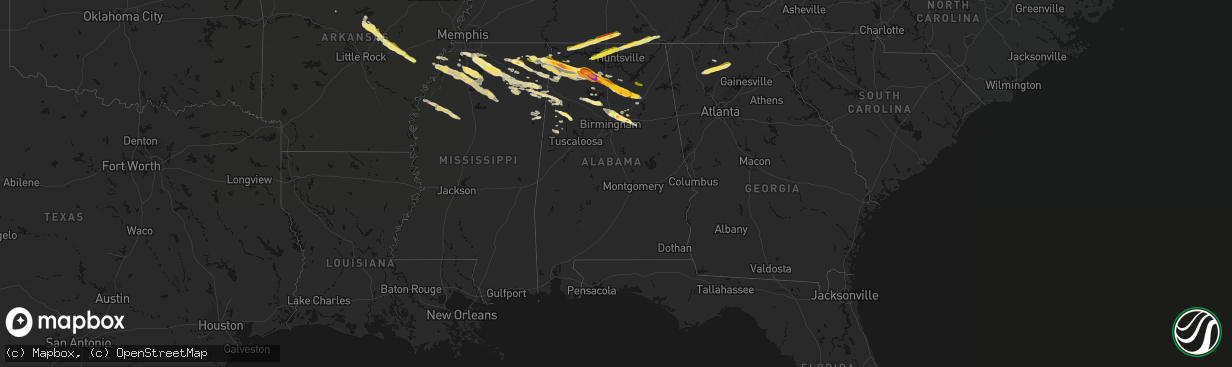
Hail Map in Alabama on February 26, 2026
The weather event in Alabama on February 26, 2026 includes Hail, Wind, and Tornado maps. 6 states and 207 cities were impacted and suffered possible damage. The total estimated number of properties impacted is 100,432.
Hail
Wind
Tornado
100,432
Estimated number of impacted properties by a 1.00" hail or larger51,740
Estimated number of impacted properties by a 1.75" hail or larger0
Estimated number of impacted properties by a 2.50" hail or largerStorm reports in Alabama
Alabama
| Date | Description |
|---|---|
| 02/26/20265:55 PM CST | 1 to 2 inch hail measured on wagon mountain road. |
| 02/26/20265:48 PM CST | A local report indicates 1.00 inch wind near 3 S Moulton |
| 02/26/20265:42 PM CST | Quarter-size hail reported in fayette. |
| 02/26/20265:34 PM CST | Size estimated from picture. |
| 02/26/20264:20 PM CST | A local report indicates 1.00 inch wind near 8 WNW Littleville |
| 02/26/20264:17 PM CST | Up to quarter-size hail in the pell city area. |
| 02/26/20264:13 PM CST | Four to five trees were uprooted and some tree branches were broken off on some trees at this location off of whitesville road. |
| 02/26/20264:12 PM CST | At lesat one wooden cover stuctures for spectating at multiple soccer fields was heavily damaged and its roof cover was taken off. One quarter the roof on another one w |
| 02/26/20263:58 PM CST | Up to 2-inch size hail estimated from a social media picture. |
| 02/26/20263:47 PM CST | Quarter-size hail on hwy 11 bear deerfoot pkwy. |
| 02/26/20263:45 PM CST | Ping-pong to golf ball-sized hail in the trussville area. |
| 02/26/20263:40 PM CST | Ping pong to golf ball-sized hail in the chalkville and clay areas. |
| 02/26/20263:34 PM CST | Several large cedar trees uprooted along silver lake rd. |
| 02/26/20263:33 PM CST | Quarter to half dollar-size hail in the pinson area. In addition... Copious amounts of small hail coated the ground... Resulting in fog formation. |
| 02/26/20263:33 PM CST | Numerous trees and power lines down on bud holmes rd and hillview st... With reported structural damage. |
| 02/26/20263:30 PM CST | Numerous trees blown down in and around the city of pinson. Most intense damage was in a roughly 1 mile long and 1000 yard wide swath on the eastern side of the city. T |
| 02/26/20262:41 PM CST | Social media photos of quarter-size hail in the pineywoods area. |
| 02/25/20268:06 PM CST | Multiple trees down at cr 36 and wilson chapel rd near fridays crossing. |
| 02/25/20267:53 PM CST | A local report indicates 1.25 inch wind near 1 NW Hartselle |
| 02/25/20267:51 PM CST | A local report indicates 1.00 inch wind near 4 W New Market |
| 02/25/20267:47 PM CST | Photo indicated hail of up to 2.25 inches in diameter. Time estimated by radar. |
| 02/25/20267:40 PM CST | Quarter sized hail reported on lucas ferry road. Time estimated by radar. |
| 02/25/20267:40 PM CST | A local report indicates 1.25 inch wind near 1 SSW Hazel Green |
| 02/25/20267:35 PM CST | Up to golf ball-size hail on the blount county side of altoona. |
| 02/25/20267:27 PM CST | Corrects previous tstm wnd dmg report from 2 se susan moore. Multiple trees down at cr 36 and wilson chapel rd near fridays crossing. |
| 02/25/20267:23 PM CST | Up to 2-inch hail in the susan moore area via social media pictures. |
| 02/25/20267:22 PM CST | Up to quarter-size hail in susan moore. |
| 02/25/20267:20 PM CST | A local report indicates 1.25 inch wind near 1 N Anderson |
| 02/25/20267:20 PM CST | A tree was knocked down and blocking the roadway at 570 roundtop road. Time estimated by radar. |
| 02/25/20267:20 PM CST | Corrects previous hail report from 1 nw hartselle. Time estimated by radar. |
| 02/25/20267:12 PM CST | Quarter sized hail between holly pond and county line. |
| 02/25/20267:11 PM CST | A few trees down around blountsville. |
| 02/25/20267:11 PM CST | Reports of 2-inch hail in blountsville. |
| 02/25/20267:10 PM CST | Hail was very spiky and was just over an inch big. |
| 02/25/20267:10 PM CST | A tree was knocked down blocking the roadway at the intersection of gum springs road and bert stinson road. Time estimated by radar. |
| 02/25/20267:09 PM CST | A local report indicates 1.00 inch wind near Harvest |
| 02/25/20267:09 PM CST | A local report indicates 1.50 inch wind near 4 N Brushy Lake |
| 02/25/20267:03 PM CST | Quarter sized hail reported between cullman and holly pond. |
| 02/25/20267:00 PM CST | Corrects previous hail report from 2 sse holly pond. Roof damage and vehicle lights shattered at 1994 cr 698. Photo of hail with estimated size. Time estimated by radar |
| 02/25/20267:00 PM CST | Hail damage to a vehicle and manufactured home on cr 698 near holly pond. |
| 02/25/20267:00 PM CST | A local report indicates 1.00 inch wind near 1 NNW Killen |
| 02/25/20266:52 PM CST | Wind blown hail broke windows at a residence in the aldridge grove community. Time estimated by radar. |
| 02/25/20266:49 PM CST | A local report indicates 1.00 inch wind near Athens |
| 02/25/20266:47 PM CST | Corrects previous hail report from 2 w south vinemont. Photo indicated hail of up to 2.25 inches in diameter. Time estimated by radar. |
| 02/25/20266:46 PM CST | A local report indicates 1.25 inch wind near 2 NW Athens |
| 02/25/20266:45 PM CST | A local report indicates 1.00 inch wind near 4 NE Athens |
| 02/25/20266:41 PM CST | Video from this location showed at least quarter size hail on the ground at 5841 cr 25 in the green hill area. Time esteimated from radar. |
| 02/25/20266:34 PM CST | A local report indicates 1.25 inch wind near 9 E Russellville |
| 02/25/20266:33 PM CST | A local report indicates 1.25 inch wind near 1 NE Triana |
| 02/25/20266:18 PM CST | Ping pong sized hail reported in northern russellville. |
| 02/25/20266:16 PM CST | A local report indicates 1.25 inch wind near 2 W Russellville |
| 02/25/20266:10 PM CST | Size estimated from photo. |
| 02/25/20266:06 PM CST | Two inch in diameter hail was reported in teh danvlile area. |
| 02/25/20266:06 PM CST | Quarter sized hail reported in danville. |
| 02/25/20266:06 PM CST | Corrects previous hail report from 9 w hartselle. Two inch in diameter hail was reported in the danville area. |
All States Impacted by Hail Map on February 26, 2026
Cities Impacted by Hail Map on February 26, 2026
- Philadelphia, PA
- Nauvoo, AL
- Jasper, AL
- Bremen, AL
- Empire, AL
- Dora, AL
- Warrior, AL
- Morris, AL
- Birmingham, AL
- Gardendale, AL
- Kimberly, AL
- Jerusalem, AR
- Pinson, AL
- Trussville, AL
- Moody, AL
- Odenville, AL
- Pell City, AL
- Leeds, AL
- Quitman, AR
- Cropwell, AL
- Albertville, AL
- Boaz, AL
- Tuscumbia, AL
- Cherokee, AL
- Russellville, AL
- Enola, AR
- Mount Vernon, AR
- Greenbrier, AR
- Rose Bud, AR
- Romance, AR
- Searcy, AR
- El Paso, AR
- Beebe, AR
- McRae, AR
- Tishomingo, MS
- Booneville, MS
- Dennis, MS
- Vernon, AL
- Rienzi, MS
- Iuka, MS
- Oxford, MS
- Abbeville, MS
- Fayette, AL
- Mount Hope, AL
- Blue Mountain, MS
- Town Creek, AL
- Reform, AL
- Amory, MS
- Ward, AR
- Moulton, AL
- Des Arc, AR
- Carlisle, AR
- Hickory Plains, AR
- Hazen, AR
- Danville, AL
- Ripley, MS
- Smithville, MS
- Lonoke, AR
- Dumas, MS
- Pontotoc, MS
- Baldwyn, MS
- Vinemont, AL
- Falkville, AL
- Addison, AL
- Hartselle, AL
- Biscoe, AR
- Hillsboro, AL
- Bankston, AL
- Berry, AL
- Shannon, MS
- Belmont, MS
- De Valls Bluff, AR
- Brinkley, AR
- Cullman, AL
- Fairmount, GA
- Athens, AL
- Marietta, MS
- Sulligent, AL
- Nettleton, MS
- Red Bay, AL
- Plantersville, MS
- Golden, MS
- Clarendon, AR
- Holly Grove, AR
- Beaverton, AL
- Marianna, AR
- Tunica, MS
- Talking Rock, GA
- Jasper, GA
- Ranger, GA
- Florence, AL
- Fulton, MS
- Tanner, AL
- Gordo, AL
- Thaxton, MS
- Vina, AL
- Holly Pond, AL
- Hanceville, AL
- Killen, AL
- Detroit, AL
- Spruce Pine, AL
- Greenwood Springs, MS
- Guin, AL
- Etta, MS
- Hodges, AL
- Tremont, MS
- Winfield, AL
- Hernando, MS
- Lexa, AR
- New Albany, MS
- Lexington, AL
- Dawsonville, GA
- Ellijay, GA
- Blountsville, AL
- West Helena, AR
- Helena, AR
- Dundee, MS
- Harvest, AL
- Toney, AL
- Madison, AL
- Rogersville, AL
- Phil Campbell, AL
- Huntsville, AL
- Anderson, AL
- Five Points, TN
- Horton, AL
- Altoona, AL
- Oneonta, AL
- Lester, AL
- Minor Hill, TN
- West Point, MS
- Sledge, MS
- Coahoma, MS
- Coldwater, MS
- Byhalia, MS
- Belden, MS
- Tupelo, MS
- Senatobia, MS
- Sarah, MS
- Cleveland, AL
- Haleyville, AL
- Hamilton, AL
- Gallant, AL
- Attalla, AL
- Holly Springs, MS
- Prospect, TN
- Goodspring, TN
- Como, MS
- Columbus, MS
- Caledonia, MS
- Hazel Green, AL
- Meridianville, AL
- Crenshaw, MS
- Sardis, MS
- Gunnison, MS
- Mooreville, MS
- Saltillo, MS
- Mantachie, MS
- Waterford, MS
- Mound Bayou, MS
- New Market, AL
- Batesville, MS
- Pulaski, TN
- Ardmore, TN
- Dellrose, TN
- Potts Camp, MS
- Drew, MS
- Merigold, MS
- Courtland, MS
- Arley, AL
- Fayetteville, TN
- Frankewing, TN
- Estillfork, AL
- Huntland, TN
- Ruleville, MS
- Water Valley, MS
- Pope, MS
- Taylor, MS
- Crane Hill, AL
- Belvidere, TN
- Myrtle, MS
- Ecru, MS
- Minter City, MS
- Sherwood, TN
- Taft, TN
- Schlater, MS
- Bruce, MS
- Philipp, MS
- Greenwood, MS
- Coffeeville, MS
- Banner, MS
- Blue Springs, MS
- Sewanee, TN
- Pittsboro, MS
- South Pittsburg, TN
- Okolona, MS
- Verona, MS
- Steele, AL
- Ashville, AL
- Baileyton, AL
- Joppa, AL
- Arab, AL
- Springville, AL
- Talladega, AL
- Hamilton, MS
- Aberdeen, MS
- Kennedy, AL


