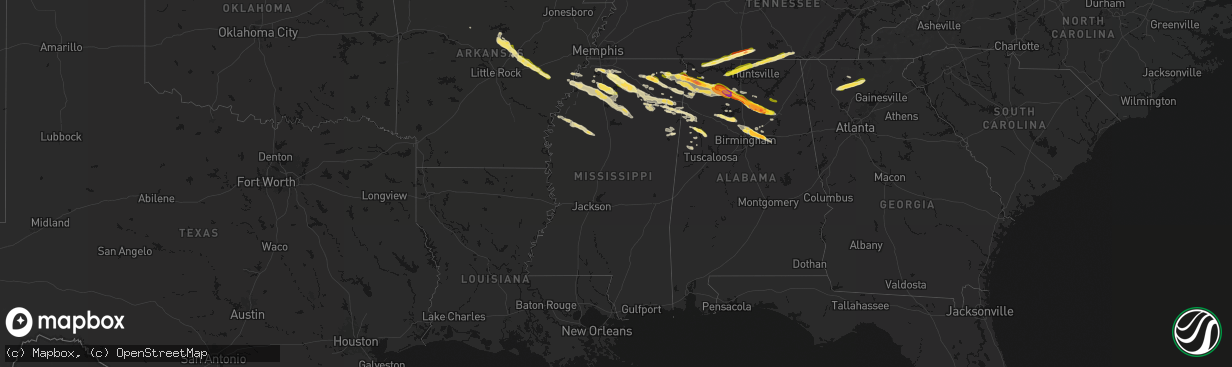
Hail Map in Mississippi on February 26, 2026
The weather event in Mississippi on February 26, 2026 includes Hail, Wind, and Tornado maps. 6 states and 207 cities were impacted and suffered possible damage. The total estimated number of properties impacted is 11,404.
Hail
Wind
Tornado
11,404
Estimated number of impacted properties by a 1.00" hail or larger757
Estimated number of impacted properties by a 1.75" hail or larger0
Estimated number of impacted properties by a 2.50" hail or largerStorm reports in Mississippi
Mississippi
| Date | Description |
|---|---|
| 02/26/20265:43 PM CST | Report of golf ball size hall in dumas. |
| 02/26/20265:34 PM CST | Photo of quarter size hail on the north side of booneville. |
| 02/26/20265:29 PM CST | A local report indicates 1.50 inch wind near 4 E Tishomingo |
| 02/26/20265:27 PM CST | Hail at lion hills golf course... Mostly small pea to penny with some up to quarter size. |
| 02/26/20265:16 PM CST | Multiple reports of quarter size hail in tishomingo county... Including the carters branch area. |
| 02/25/20268:31 PM CST | Report of wind damage to a small tent greenhouse near etta. |
| 02/25/20268:16 PM CST | Penny hail with some as large as quarters. |
| 02/25/20268:10 PM CST | Half-dollar-sized hail off of heafner rd. |
| 02/25/20268:01 PM CST | Quarter-sized hail on pamela st. |
| 02/25/20267:55 PM CST | A local report indicates 1.00 inch wind near Laws Hill |
| 02/25/20267:49 PM CST | Photo of estimated quarter size hail in sardis. |
| 02/25/20267:47 PM CST | Photo of 1.25 inch hail in como. |
| 02/25/20267:36 PM CST | Photo of quarter size hail in thyatira. |
| 02/25/20267:23 PM CST | Photo of quarter to half dollar size hail. |
| 02/25/20266:39 PM CST | A local report indicates 1.00 inch wind near 3 NNE Fairview |
All States Impacted by Hail Map on February 26, 2026
Cities Impacted by Hail Map on February 26, 2026
- Philadelphia, PA
- Nauvoo, AL
- Jasper, AL
- Bremen, AL
- Empire, AL
- Dora, AL
- Warrior, AL
- Morris, AL
- Birmingham, AL
- Gardendale, AL
- Kimberly, AL
- Jerusalem, AR
- Pinson, AL
- Trussville, AL
- Moody, AL
- Odenville, AL
- Pell City, AL
- Leeds, AL
- Quitman, AR
- Cropwell, AL
- Albertville, AL
- Boaz, AL
- Tuscumbia, AL
- Cherokee, AL
- Russellville, AL
- Enola, AR
- Mount Vernon, AR
- Greenbrier, AR
- Rose Bud, AR
- Romance, AR
- Searcy, AR
- El Paso, AR
- Beebe, AR
- McRae, AR
- Tishomingo, MS
- Booneville, MS
- Dennis, MS
- Vernon, AL
- Rienzi, MS
- Iuka, MS
- Oxford, MS
- Abbeville, MS
- Fayette, AL
- Mount Hope, AL
- Blue Mountain, MS
- Town Creek, AL
- Reform, AL
- Amory, MS
- Ward, AR
- Moulton, AL
- Des Arc, AR
- Carlisle, AR
- Hickory Plains, AR
- Hazen, AR
- Danville, AL
- Ripley, MS
- Smithville, MS
- Lonoke, AR
- Dumas, MS
- Pontotoc, MS
- Baldwyn, MS
- Vinemont, AL
- Falkville, AL
- Addison, AL
- Hartselle, AL
- Biscoe, AR
- Hillsboro, AL
- Bankston, AL
- Berry, AL
- Shannon, MS
- Belmont, MS
- De Valls Bluff, AR
- Brinkley, AR
- Cullman, AL
- Fairmount, GA
- Athens, AL
- Marietta, MS
- Sulligent, AL
- Nettleton, MS
- Red Bay, AL
- Plantersville, MS
- Golden, MS
- Clarendon, AR
- Holly Grove, AR
- Beaverton, AL
- Marianna, AR
- Tunica, MS
- Talking Rock, GA
- Jasper, GA
- Ranger, GA
- Florence, AL
- Fulton, MS
- Tanner, AL
- Gordo, AL
- Thaxton, MS
- Vina, AL
- Holly Pond, AL
- Hanceville, AL
- Killen, AL
- Detroit, AL
- Spruce Pine, AL
- Greenwood Springs, MS
- Guin, AL
- Etta, MS
- Hodges, AL
- Tremont, MS
- Winfield, AL
- Hernando, MS
- Lexa, AR
- New Albany, MS
- Lexington, AL
- Dawsonville, GA
- Ellijay, GA
- Blountsville, AL
- West Helena, AR
- Helena, AR
- Dundee, MS
- Harvest, AL
- Toney, AL
- Madison, AL
- Rogersville, AL
- Phil Campbell, AL
- Huntsville, AL
- Anderson, AL
- Five Points, TN
- Horton, AL
- Altoona, AL
- Oneonta, AL
- Lester, AL
- Minor Hill, TN
- West Point, MS
- Sledge, MS
- Coahoma, MS
- Coldwater, MS
- Byhalia, MS
- Belden, MS
- Tupelo, MS
- Senatobia, MS
- Sarah, MS
- Cleveland, AL
- Haleyville, AL
- Hamilton, AL
- Gallant, AL
- Attalla, AL
- Holly Springs, MS
- Prospect, TN
- Goodspring, TN
- Como, MS
- Columbus, MS
- Caledonia, MS
- Hazel Green, AL
- Meridianville, AL
- Crenshaw, MS
- Sardis, MS
- Gunnison, MS
- Mooreville, MS
- Saltillo, MS
- Mantachie, MS
- Waterford, MS
- Mound Bayou, MS
- New Market, AL
- Batesville, MS
- Pulaski, TN
- Ardmore, TN
- Dellrose, TN
- Potts Camp, MS
- Drew, MS
- Merigold, MS
- Courtland, MS
- Arley, AL
- Fayetteville, TN
- Frankewing, TN
- Estillfork, AL
- Huntland, TN
- Ruleville, MS
- Water Valley, MS
- Pope, MS
- Taylor, MS
- Crane Hill, AL
- Belvidere, TN
- Myrtle, MS
- Ecru, MS
- Minter City, MS
- Sherwood, TN
- Taft, TN
- Schlater, MS
- Bruce, MS
- Philipp, MS
- Greenwood, MS
- Coffeeville, MS
- Banner, MS
- Blue Springs, MS
- Sewanee, TN
- Pittsboro, MS
- South Pittsburg, TN
- Okolona, MS
- Verona, MS
- Steele, AL
- Ashville, AL
- Baileyton, AL
- Joppa, AL
- Arab, AL
- Springville, AL
- Talladega, AL
- Hamilton, MS
- Aberdeen, MS
- Kennedy, AL


