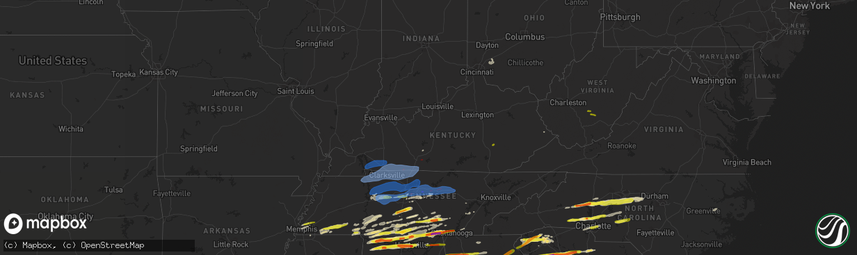
Hail Map in Kentucky on March 1, 2017
The weather event in Kentucky on March 1, 2017 includes Hail, Wind, and Tornado maps. 11 states and 605 cities were impacted and suffered possible damage. The total estimated number of properties impacted is 313.
Hail
Wind
Tornado
313
Estimated number of impacted properties by a 1.00" hail or larger0
Estimated number of impacted properties by a 1.75" hail or larger0
Estimated number of impacted properties by a 2.50" hail or largerStorm reports in Kentucky
Kentucky
| Date | Description |
|---|---|
| 03/01/20179:13 AM CST | A tree was reported to have been blown down. The time of the event is estimated from radar data. |
| 03/01/20179:08 AM CST | A tree was blown down on a home. The time of the event is estimated from radar. |
| 03/01/20179:07 AM CST | A carport was blown over at a residence. |
| 03/01/20179:03 AM CST | Two large pine trees downed. |
| 03/01/20179:01 AM CST | Metal roofing material was peeled up on a garage along ky highway 7. This a public report via social media. The time of the event is estimated from radar data. |
| 03/01/20179:01 AM CST | Shingles were blown off of homes in the tram community per wmdj. |
| 03/01/20179:01 AM CST | Portion of mobile home bedroom ripped out. A 2x4 is embedded in structure.info from social media post. |
| 03/01/20178:57 AM CST | A barn was reported to have been blown over. The time of the event is estimated from radar data. |
| 03/01/20178:54 AM CST | An awning was blown down and a flag pole was blown over at the pikeville high school. |
| 03/01/20178:50 AM CST | A mobile home was rolled off of its foundation and two additional mobile homes were shifted off of their foundations. |
| 03/01/20178:50 AM CST | Roofs were reported to have been damaged. This is public report via social media. |
| 03/01/20178:45 AM CST | A tree was reported to have been blown down on meadow creek road. The time of the event is estimated from radar data. |
| 03/01/20178:45 AM CST | Roof damage to a barn. This is a public report via social media. The time of the event is estimated from radar data. |
| 03/01/20178:42 AM CST | Roof damaged on a house and a well pump house turned over on sugarloaf branch road. |
| 03/01/20178:40 AM CST | A local report indicates 68 MPH wind near 5 N HINDMAN |
| 03/01/20178:35 AM CST | A 20x24 outbuilding was blown off its foundation. Numerous trees downed. |
| 03/01/20178:28 AM CST | Tree down. |
| 03/01/20178:27 AM CST | Roof damage to a building in downtown paintsville. This is a public report via social media. The time of the event is estimated from radar data. |
| 03/01/20178:25 AM CST | Measured by weather station at oneida baptist institute. |
| 03/01/20178:20 AM CST | Two trees and large limbs were blown down. The time is estimated from radar. |
| 03/01/20178:19 AM CST | Tree down blocking roadway on ky 3 via ema |
| 03/01/20178:17 AM CST | Several mobile homes damaged. |
| 03/01/20178:17 AM CST | Tree down on boggs road. |
| 03/01/20178:15 AM CST | Large pine tree snapped with several other smaller trees and limbs down along hwy 315 and hwy 1933. |
| 03/01/20178:15 AM CST | Trees snapped and uprooted. Numerous large trees down. |
| 03/01/20178:15 AM CST | Large pine tree down. Numerous trees downed on 1812. |
| 03/01/20178:15 AM CST | Tree down. |
| 03/01/20178:15 AM CST | Roof of a metal building was blown into roadway blocking the road near mile marker 26.a large tree between mile markers 27 and 28. |
| 03/01/20178:14 AM CST | Several barns flattened. |
| 03/01/20178:14 AM CST | Large limbs were blown down. Time is estimated from radar data. |
| 03/01/20178:12 AM CST | Large tree across round pond rd. |
| 03/01/20178:12 AM CST | Roof damaged on a house and a well pump house turned over on sugarloaf branch road. |
| 03/01/20178:11 AM CST | Multiple power poles down tyree chapel road at hendricks road. |
| 03/01/20178:11 AM CST | Quarter inch hail along with several large tree limbs greater than 2 inches in diameter. |
| 03/01/20178:10 AM CST | Damage to the marathon station by mcdonalds in jackson. Gas pumps overturned. |
| 03/01/20178:10 AM CST | Wooden shed blown over at headstart. Heavy plastic playset was blown from playground. |
| 03/01/20178:10 AM CST | 62 mph winds reported by raws at the julian carroll airport. |
| 03/01/20178:10 AM CST | Possible tornado in jackson. |
| 03/01/20178:05 AM CST | Trees were reported to have been blown down. The time of the event is estimated from radar data. |
| 03/01/20178:03 AM CST | Two large pine trees downed. |
| 03/01/20178:02 AM CST | Storm survey observed microburst. Doors blown in at local business... Ac unit hurled from roof... Power lines down... Trees down |
| 03/01/20178:02 AM CST | Barn was knocked off foundation. Below the barn... There is a 30 foot swath of upended trees. |
| 03/01/20178:02 AM CST | 50 foot pine tree knocked over. |
| 03/01/20178:01 AM CST | Multiple trees and power lines down. |
| 03/01/20178:00 AM CST | Tree blocking ky 201 via ema |
| 03/01/20178:00 AM CST | Trees were reported to have been blown down. The time of the event was estimated from radar data. |
| 03/01/20178:00 AM CST | Several trees and power lines down. |
| 03/01/20178:00 AM CST | Large trees were blown down. This is a public report via social media. |
| 03/01/20178:00 AM CST | Trees were reported to have been blown down. |
| 03/01/20177:55 AM CST | Trees down along sr 1 |
| 03/01/20177:55 AM CST | Power lines down at highway 501 and 1649. |
| 03/01/20177:55 AM CST | Trees down on highway 715 near whistling arch. |
| 03/01/20177:55 AM CST | Multiple trees and power lines down. |
| 03/01/20177:54 AM CST | Two houses with roofs blown off and trees inside homes in the 1400 - 1600 block of new yellow rock road. |
| 03/01/20177:50 AM CST | Dumpster was blown into the neighbors yard...trees were blown into a home...damage to the roof of a home..and a post to the porch of a home was blown off. The time of t |
| 03/01/20177:49 AM CST | Around 50 large trees and privacy fences were blown down. A tree fell on a home and powerlines were blown across bear track road. The time of the event is estimated fro |
| 03/01/20177:47 AM CST | Trees were reported to have been blown down. |
| 03/01/20177:46 AM CST | High winds felled multiple trees along highway 52... Highway 399... And highway 498 in west central lee county. Several homes incurred roof damage. One tree located alo |
| 03/01/20177:45 AM CST | Trees were reported to have been blown donw. |
| 03/01/20177:45 AM CST | Trees were reported to have been blown down. |
| 03/01/20177:42 AM CST | School super said trees down in the miller creek area. Phone line down in south irvine. |
| 03/01/20177:40 AM CST | Mutiple trees and some buildings damaged. |
| 03/01/20177:40 AM CST | Several barns and homes with roof damage or roofs blown off. The time of the event is estimated from radar data. |
| 03/01/20177:40 AM CST | Em reported power outage to city of franklin. Power lines and poles down... One east side of town and another on tyree chapel rd and hendrix rd. |
| 03/01/20177:40 AM CST | Multiple structures damaged. |
| 03/01/20177:38 AM CST | Mobile home was destroyed and roof off of a home next door. The time of the event is estimated from radar data. |
| 03/01/20177:36 AM CST | From 500 block to 7th street... Numerous homes with significant damage. Some with roofs blown off. Several outbuildings blown off foundations. Power is out across much |
| 03/01/20177:36 AM CST | *** 1 inj *** high winds impacted several structures between irvine and ravenna. Damage was confined to mainly roof tops of several homes and businesses in the area. Da |
| 03/01/20177:35 AM CST | Large tree limbs and branches down greater than 2 inches in diameter.penny size hail. |
| 03/01/20177:35 AM CST | From the 500 block of irvine to 7th street in ravenna... Numerous homes with significant damage. Some with roofs off. Several outbuildings blown off foundations. Power |
| 03/01/20177:35 AM CST | Mobile home flipped.report via broadcast media social media post. |
| 03/01/20177:33 AM CST | A tree was blown down in the heartbreak ridge area. This is a public report via social media. The time of the event is estimated from radar data. |
| 03/01/20177:31 AM CST | *** 1 inj *** microburst straight line wind damage consistent with 90 to 100 mph wind speeds. One resident was injured by flying glass as he tried to shut his front doo |
| 03/01/20177:30 AM CST | Kentucky mesonet site. |
| 03/01/20177:30 AM CST | Kentucky mesonet site. |
| 03/01/20177:30 AM CST | Tree over caney fork road near cale brown road. |
| 03/01/20177:30 AM CST | Former tv met reports large trees uprooted and residential fence damaged from straight line winds |
| 03/01/20177:27 AM CST | Several mature trees snapped and uprooted blocking martinsville ford road and damaged a wooden fence. Outbuilding also damaged. . |
| 03/01/20177:24 AM CST | The nws in conjunction with warren county emergency management agency determined a high end ef-1 tornado touched down in southeastern warren county... East of i-65 near |
| 03/01/20177:21 AM CST | Multiple structures damaged. |
| 03/01/20177:20 AM CST | Multiple structures damged near 292 martinsville rd. |
| 03/01/20177:20 AM CST | Trees down... Houses damaged on jack johnson road. |
| 03/01/20177:20 AM CST | Barn destroyed... Time estimated. |
| 03/01/20177:19 AM CST | Gas station damage on berea rd. |
| 03/01/20177:17 AM CST | Trees snapped and roof damage. |
| 03/01/20177:16 AM CST | Multiple structures damaged on cemetery road. |
| 03/01/20177:14 AM CST | Tombstones at church knocked over. |
| 03/01/20177:14 AM CST | Top half of silo destroyed by flying debris. Time estimated based on radar. |
| 03/01/20177:14 AM CST | Roof removed from brick house. Numerous trees down along buck lick branch rd. Time estimated from radar. |
| 03/01/20177:12 AM CST | Large tree across round pond rd. |
| 03/01/20177:11 AM CST | Multiple power poles down tyree chapel road at hendricks road. |
| 03/01/20177:11 AM CST | Barn flattened. |
| 03/01/20177:10 AM CST | Emergency manager reports straight-line wind damage on poplar grove road. Damage included a collapsed garage... Trees down with one across two vehicles and one on a hou |
| 03/01/20177:10 AM CST | A storm survey conducted by nws jackson concluded that two areas of straight line wind damage occurred near richmond... Ky. The most significant damage occurred just so |
| 03/01/20177:10 AM CST | Power is out and spotter estimates 55-60 mph winds. |
| 03/01/20177:04 AM CST | Power lines downed on a house in north central taylor county. |
| 03/01/20177:03 AM CST | Trees down county wide. Emergency manager will call back with more detail. |
| 03/01/20177:03 AM CST | Roofs blown off in sharpsburg at 167 main street and 120 back street. |
| 03/01/20177:00 AM CST | Multiple barns destroyed. Sheet metal in trees. . |
| 03/01/20177:00 AM CST | Two trees were blown down. |
| 03/01/20176:59 AM CST | Approximately 30 large trees down...2 buildings plus a hay barn damaged. . |
| 03/01/20176:57 AM CST | Large tree limbs down. |
| 03/01/20176:57 AM CST | Many trees down on the roadway. Roof blown off a sun room. . |
| 03/01/20176:57 AM CST | A nws nashville storm survey concluded that an ef-1 tornado touched down just se of adairville... Traveled 1.5 miles... And then lifted approximately 2.5 miles east of |
| 03/01/20176:56 AM CST | A local report indicates 70 MPH wind near KFGX FLEMING-MASON APT |
| 03/01/20176:55 AM CST | Kentucky mesonet site. |
| 03/01/20176:55 AM CST | *** 2 inj *** mobile home destroyed. 2 minor injuries. Another mobile home and barn with roofs off. Trees down. Utility poles down. . |
| 03/01/20176:53 AM CST | Trees reported down at mammoth cave national park. |
| 03/01/20176:50 AM CST | Corrected for time. The national weather service conducted a storm survey in northern bourbon county and determined two concentrated areas of straight-line wind damage. |
| 03/01/20176:45 AM CST | Communication tower bent near the lewisburg volunteer fire department. |
| 03/01/20176:45 AM CST | Overturned semi near mile marker 129 on i-75 . |
| 03/01/20176:45 AM CST | Trailer overturned and people rescued. Debris on us 68. Time estimated from radar. |
| 03/01/20176:45 AM CST | Outbuildings belonging to the university of kentucky were damaged at newtown pike and interstate 75. |
| 03/01/20176:43 AM CST | Home destroyed and several trees down on kentucky 18. |
| 03/01/20176:40 AM CST | Measured at ky mesonet site |
| 03/01/20176:40 AM CST | Barn destroyed on henson ridge. |
| 03/01/20176:33 AM CST | *** 1 inj *** corrected for time. The national weather service in conjunction with harrison county emergency management determined the area northeast of cynthiana along |
| 03/01/20176:30 AM CST | The national weather service in conjunction with scott county emergency management found significant straight line wind damage 2 miles northeast of stamping ground... K |
| 03/01/20176:30 AM CST | Business lost a roof. |
| 03/01/20176:30 AM CST | Tree on a home. |
| 03/01/20176:30 AM CST | Structural damage to a business. |
| 03/01/20176:30 AM CST | Multiple roofs off homes and damage to farm structures in the peaks mill community. |
| 03/01/20176:30 AM CST | Metal roof damage. |
| 03/01/20176:30 AM CST | Report at pembroke fire dept |
| 03/01/20176:30 AM CST | Tree on power lines near the county emergency operations center. |
| 03/01/20176:27 AM CST | Measured at fort campbell |
| 03/01/20176:25 AM CST | Tree uprooted. |
| 03/01/20176:22 AM CST | . |
| 03/01/20176:22 AM CST | Limbs stripped off trees around a house. |
| 03/01/20176:20 AM CST | Barn destroyed. Photos verified from social media. |
| 03/01/20176:20 AM CST | Large tree down on a barn. |
| 03/01/20176:20 AM CST | Semi overturned on interstate 75 at mile marker 129. Outbuildings flattened. Several trees down. |
| 03/01/20176:20 AM CST | 2 barns on route 8 destroyed. |
| 03/01/20176:20 AM CST | House sustained major damage on snag creek road. Wide path of damage from aa highway to snag creek road. |
| 03/01/20176:20 AM CST | Measured at ky mesonet site |
| 03/01/20176:20 AM CST | Barn destroyed on eden ridge road near foster. |
| 03/01/20176:16 AM CST | Trees uprooted or snapped. Roof blown off. From mping. |
| 03/01/20176:15 AM CST | Sheds blown down. |
| 03/01/20176:10 AM CST | A local report indicates 70 MPH wind near MORTONS GAP |
| 03/01/20176:10 AM CST | Large tree down and porch uplifted and blown downwind several hundred yards. |
| 03/01/20176:10 AM CST | Measured along hwy 68-80 at christian county line |
| 03/01/20176:10 AM CST | The nws in conjunction with 911 operator deron rambo found intermittent straight line wind damage around peak's mill. The most concentrated area of damage was near the |
| 03/01/20176:08 AM CST | Nws storm survey confirms straight line wind damage near alexandria. A few trees were downed and minor structural damage occurred to a home. |
| 03/01/20176:06 AM CST | Nws storm survey confirms straight line wind damage near morning view. One barn was mostly destroyed and other barns were damaged. |
| 03/01/20176:05 AM CST | Tree down on nortonville road blocking the road |
| 03/01/20176:04 AM CST | Trees down across the county on highway 44... Lilly pike... And stevens lane. . |
| 03/01/20176:03 AM CST | Multiple trees and light poles down. Tractor trailer blown over. Business signs blown down. |
| 03/01/20176:02 AM CST | Large tree uprooted. Barn destroyed and garage heavily damaged. Estimated wind speed 85 mph. |
| 03/01/20176:00 AM CST | *** 1 inj *** the national weather service in conjunction with harrison county emergency management determined the area northeast of cynthiana along salem pike had 70-8 |
| 03/01/20176:00 AM CST | . |
| 03/01/20176:00 AM CST | Multiple shingles off roofs... Siding blown off... Trees down in the neighborhood of pritchard lane. |
| 03/01/20176:00 AM CST | The national weather service conducted a storm survey in northern bourbon county and determined two concentrated areas of straight-line wind damage. The first area was |
| 03/01/20176:00 AM CST | Trees snapped or uprooted in various parts of the county. |
| 03/01/20176:00 AM CST | 69.9 mph measured on allen circle |
All States Impacted by Hail Map on March 1, 2017
Cities Impacted by Hail Map on March 1, 2017
- Ball Ground, GA
- Canton, GA
- Pickens, MS
- Smiths Grove, KY
- Brownsville, KY
- Clinton, SC
- Laurens, SC
- Sallis, MS
- Mantee, MS
- Mathiston, MS
- Bellefontaine, MS
- Eupora, MS
- Maben, MS
- West Point, MS
- Columbus, MS
- Ardmore, TN
- Taft, TN
- Prospect, TN
- Kannapolis, NC
- Lincolnton, NC
- Bessemer City, NC
- Iron Station, NC
- Mount Holly, NC
- Davidson, NC
- Concord, NC
- Rockwell, NC
- Stanley, NC
- Dallas, NC
- Alexis, NC
- Huntersville, NC
- Courtland, AL
- Town Creek, AL
- Leighton, AL
- Tuscumbia, AL
- Ethel, MS
- Kosciusko, MS
- Louisville, MS
- Macon, MS
- Noxapater, MS
- McCool, MS
- Alexander City, AL
- Jacksons Gap, AL
- Statesville, NC
- Harmony, NC
- Olin, NC
- Mocksville, NC
- Greenville, SC
- Liberty, SC
- Salem, SC
- Pickens, SC
- Central, SC
- Easley, SC
- Taylors, SC
- Seneca, SC
- Six Mile, SC
- Blackstock, SC
- Great Falls, SC
- Lancaster, SC
- Heath Springs, SC
- Michie, TN
- Counce, TN
- Tullahoma, TN
- Manchester, TN
- Altamont, TN
- Pelham, TN
- Prairie, MS
- Hamilton, MS
- Aberdeen, MS
- Caledonia, MS
- Savannah, TN
- Shiloh, TN
- Sawyerville, AL
- Boligee, AL
- Eutaw, AL
- Blanchester, OH
- Clarksville, OH
- Morrow, OH
- Gruetli Laager, TN
- Hillsboro, TN
- Coalmont, TN
- Estill Springs, TN
- Tracy City, TN
- Washington, NC
- Waynesboro, TN
- South Pittsburg, TN
- Jasper, TN
- Sherwood, TN
- Guin, AL
- Winfield, AL
- Randleman, NC
- Climax, NC
- Lexington, NC
- Pleasant Garden, NC
- Franklinville, NC
- Staley, NC
- High Point, NC
- Sophia, NC
- Trinity, NC
- Liberty, NC
- Thomasville, NC
- Greensboro, NC
- Julian, NC
- Snow Camp, NC
- Florence, AL
- Brent, AL
- Moundville, AL
- Mountville, SC
- Kinards, SC
- Joanna, SC
- Fayetteville, TN
- Dellrose, TN
- Gardendale, AL
- Graysville, AL
- Dora, AL
- Hickory, NC
- Conover, NC
- Walhalla, SC
- Quinton, AL
- Charlotte, NC
- College Grove, TN
- Olivehill, TN
- Hohenwald, TN
- Clifton, TN
- Franklin, TN
- Nolensville, TN
- Ethridge, TN
- Lawrenceburg, TN
- Vardaman, MS
- Charleston, MS
- Cleveland, NC
- Catawba, NC
- Claremont, NC
- Stony Point, NC
- Centreville, AL
- Gurley, AL
- Carnesville, GA
- Columbia, TN
- Eagleville, TN
- Chapel Hill, TN
- Lewisburg, TN
- Goodman, MS
- Lexington, MS
- Waterloo, SC
- Hodges, SC
- Fayette, AL
- Kennedy, AL
- Vernon, AL
- Millport, AL
- Dadeville, AL
- Berry, AL
- Alexandria, TN
- Liberty, TN
- Dowelltown, TN
- Watertown, TN
- Auburntown, TN
- Morton, MS
- Brandon, MS
- Mendenhall, MS
- Braxton, MS
- Raleigh, MS
- Florence, MS
- Whitwell, TN
- Decherd, TN
- Newnan, GA
- Huntsville, AL
- Shelbyville, TN
- Tremont, MS
- Saint Joseph, TN
- Iron City, TN
- Loretto, TN
- Advance, NC
- Woodleaf, NC
- Cooleemee, NC
- Russellville, AL
- Madison, AL
- Hillsboro, AL
- Tanner, AL
- Athens, AL
- Trinity, AL
- Brownsboro, AL
- Owens Cross Roads, AL
- Decatur, AL
- Carthage, MS
- Memphis, TN
- Leoma, TN
- Goodspring, TN
- Killen, AL
- Five Points, TN
- Minor Hill, TN
- Anderson, AL
- Rogersville, AL
- Hackleburg, AL
- Hamilton, AL
- Muscle Shoals, AL
- Lester, AL
- Elkmont, AL
- Honea Path, SC
- Belton, SC
- Ware Shoals, SC
- Donalds, SC
- Whitmire, SC
- Hazel Green, AL
- New London, NC
- Denton, NC
- Greer, SC
- Starr, SC
- Richburg, SC
- Carlisle, SC
- Bowersville, GA
- Chester, SC
- Union, SC
- Hartwell, GA
- Blair, SC
- Winnsboro, SC
- Anderson, SC
- Iva, SC
- Adairsville, GA
- Calhoun, GA
- Sulligent, AL
- Phil Campbell, AL
- Bear Creek, AL
- Double Springs, AL
- Graham, NC
- Opelousas, LA
- Church Point, LA
- Camden, AL
- Pikeville, KY
- Sidney, KY
- Tamassee, SC
- Somerville, TN
- La Grange, TN
- Hornsby, TN
- Hickory Valley, TN
- Bethel Springs, TN
- Middleton, TN
- Saulsbury, TN
- Williston, TN
- Grand Junction, TN
- Whiteville, TN
- Bolivar, TN
- Moscow, TN
- Mauldin, SC
- Simpsonville, SC
- Ellijay, GA
- Cherry Log, GA
- Pulaski, TN
- Lynnville, TN
- Union Grove, AL
- Eva, AL
- Falkville, AL
- Hartselle, AL
- Somerville, AL
- Tutwiler, MS
- Jemison, AL
- Thorsby, AL
- Randolph, AL
- Rome, GA
- Armuchee, GA
- Lavonia, GA
- Crouse, NC
- Decatur, TN
- Lascassas, TN
- Huntland, TN
- Toney, AL
- Belvidere, TN
- Stevenson, AL
- New Market, AL
- Estillfork, AL
- Ardmore, AL
- Sequatchie, TN
- Coffeeville, MS
- Bruce, MS
- Thomaston, GA
- Molena, GA
- Meansville, GA
- Rossville, GA
- Burlington, NC
- Hildebran, NC
- Linwood, NC
- Salisbury, NC
- Jasper, AL
- Shelby, NC
- Lawndale, NC
- Cherryville, NC
- Rockvale, TN
- Murfreesboro, TN
- Alexandria, AL
- Weaver, AL
- Anniston, AL
- Jacksonville, AL
- Cypress Inn, TN
- West Union, SC
- Sunset, SC
- Fort Deposit, AL
- Monteagle, TN
- Beersheba Springs, TN
- Mcminnville, TN
- Petersburg, TN
- Maplesville, AL
- Lawley, AL
- Clanton, AL
- Akron, AL
- Arley, AL
- Addison, AL
- Sontag, MS
- Brookhaven, MS
- Beaverton, AL
- Alto, GA
- Baileyton, AL
- Woodruff, SC
- Travelers Rest, SC
- Marietta, SC
- Mountain Rest, SC
- Piedmont, SC
- Westminster, SC
- Troy, NC
- Mount Gilead, NC
- Candor, NC
- Biscoe, NC
- Albemarle, NC
- Star, NC
- Morrison, TN
- Gainesville, AL
- Epes, AL
- Greensboro, AL
- Forrest City, AR
- Valdese, NC
- Morganton, NC
- Scottsboro, AL
- Cornersville, TN
- Kelso, TN
- Lutts, TN
- Lexington, AL
- Waterloo, AL
- Westpoint, TN
- Winchester, TN
- Frankewing, TN
- Mulberry, TN
- Kimberly, AL
- Pinson, AL
- Warrior, AL
- Mebane, NC
- Chapel Hill, NC
- Winston Salem, NC
- Asheboro, NC
- Connelly Springs, NC
- Bankston, AL
- Oakman, AL
- Pleasant Plain, OH
- Oregonia, OH
- Meridianville, AL
- Ranger, GA
- Fairmount, GA
- Letohatchee, AL
- Dickson, TN
- Bon Aqua, TN
- Nunnelly, TN
- Bath Springs, TN
- Linden, TN
- Collinwood, TN
- Dunlap, TN
- Danville, AL
- Brentwood, TN
- Weogufka, AL
- Arlington, TN
- Forkland, AL
- Emelle, AL
- Cedarbluff, MS
- Carbon Hill, AL
- Nauvoo, AL
- Old Fort, TN
- Milton, TN
- Seagrove, NC
- Goshen, OH
- Loveland, OH
- Talking Rock, GA
- Burnsville, MS
- Selmer, TN
- Corinth, MS
- Clover, SC
- Belmont, NC
- Odenville, AL
- McDonald, TN
- Cleveland, TN
- Elora, TN
- Bridgeport, AL
- Sewanee, TN
- Cherokee, AL
- Flintville, TN
- Harvest, AL
- Heth, AR
- Proctor, AR
- Northport, AL
- Fountain Inn, SC
- Gray Court, SC
- Culleoka, TN
- Canon, GA
- Commerce, GA
- Detroit, AL
- Crane Hill, AL
- Bremen, AL
- McEwen, TN
- Lyles, TN
- Cordova, AL
- Parrish, AL
- Only, TN
- Waverly, TN
- Burns, TN
- Hurricane Mills, TN
- Port Allen, LA
- Terry, MS
- Raymond, MS
- Utica, MS
- Crump, TN
- Adamsville, TN
- Morris Chapel, TN
- Belfast, TN
- Wartrace, TN
- Mount Pleasant, NC
- Kings Mountain, NC
- Holly Pond, AL
- Cullman, AL
- Lynchburg, TN
- Eldridge, AL
- Douglasville, GA
- Whitesburg, GA
- Winston, GA
- Palmetto, GA
- Unionville, TN
- Duncan, SC
- Lyman, SC
- Millington, TN
- Pinetown, NC
- Toxey, AL
- Smyrna, TN
- Fairview, TN
- Arab, AL
- Guntersville, AL
- Nashville, TN
- Antioch, TN
- Cornelius, NC
- Richfield, NC
- Gold Hill, NC
- Summerville, GA
- Dahlonega, GA
- Marble Hill, GA
- Dawsonville, GA
- Jasper, GA
- Plainville, GA
- Lebanon, OH
- Haleyville, AL
- Hodges, AL
- Olive Branch, MS
- Moulton, AL
- Vinemont, AL
- Houston, AL
- Grandview, TN
- Widener, AR
- Mount Pleasant, TN
- Benton, MS
- Salyersville, KY
- Pikeville, NC
- Goldsboro, NC
- Siler City, NC
- Bear Creek, NC
- Bennett, NC
- Ramseur, NC
- Cowan, TN
- Palmer, TN
- Fulton, MS
- Wesson, MS
- Niota, TN
- Annville, KY
- Guild, TN
- Whiteside, TN
- Lupton City, TN
- Signal Mountain, TN
- Chattanooga, TN
- Joppa, AL
- Grant, AL
- Langston, AL
- Valley Head, AL
- Ider, AL
- Menlo, GA
- Rising Fawn, GA
- Flat Rock, AL
- Hollywood, AL
- Pisgah, AL
- Steens, MS
- Mount Olive, AL
- Townley, AL
- Sumiton, AL
- Eagle Springs, NC
- Lebanon, TN
- Monterey, TN
- Hico, WV
- Lansing, WV
- Victor, WV
- Nallen, WV
- Quinwood, WV
- Rainelle, WV
- Canton, MS
- Camden, MS
- Byram, MS
- Union, MS
- Lena, MS
- Sebastopol, MS
- Walnut Grove, MS
- Forest, MS
- Lyerly, GA
- Cornelia, GA
- Toccoa, GA
- Lula, GA
- Gainesville, GA
- Mount Airy, GA
- Baldwin, GA
- Martin, GA
- Homer, GA
- Duluth, GA
- Suwanee, GA
- Alpharetta, GA
- Buford, GA
- Lawrenceville, GA
- Arnaudville, LA
- Port Barre, LA
- Cadiz, KY
- Herndon, KY
- Gracey, KY
- Pembroke, KY
- Hopkinsville, KY
- Indian Mound, TN
- Big Sandy, TN
- Greenbrier, TN
- Chapmansboro, TN
- Adairville, KY
- White House, TN
- Westmoreland, TN
- Cottontown, TN
- Portland, TN
- Palmyra, TN
- Cross Plains, TN
- Ashland City, TN
- Franklin, KY
- Dover, TN
- Clarksville, TN
- Springville, TN
- Orlinda, TN
- Elkton, KY
- Allensville, KY
- Scottsville, KY
- Fort Campbell, KY
- Olmstead, KY
- Pleasant View, TN
- Cedar Hill, TN
- Buchanan, TN
- Cumberland City, TN
- Oak Grove, KY
- Russellville, KY
- Guthrie, KY
- Stewart, TN
- Tennessee Ridge, TN
- Adolphus, KY
- Cunningham, TN
- Springfield, TN
- Woodlawn, TN
- Trenton, KY
- Adams, TN
- Big Rock, TN
- Hendersonville, TN
- Castalian Springs, TN
- Gallatin, TN
- Madison, TN
- Whites Creek, TN
- Goodlettsville, TN
- Kingston Springs, TN
- Charlotte, TN
- Southside, TN
- Erin, TN
- Hermitage, TN
- Mount Juliet, TN
- Pegram, TN
- Joelton, TN
- White Bluff, TN
- Vanleer, TN
- Cumberland Furnace, TN
- Old Hickory, TN
- Lancaster, TN
- Silver Point, TN
- Baxter, TN
- Smithville, TN
- La Vergne, TN
- Cookeville, TN
- Chestnut Mound, TN
- Centerville, TN
- Buffalo Valley, TN
- Primm Springs, TN
- Elmwood, TN
- Bloomington Springs, TN
- Carthage, TN
- Brush Creek, TN
- Sparta, TN
- Hickman, TN
- Gordonsville, TN
- Duck River, TN
- Bowling Green, KY


