Hail Map in Mississippi on March 7, 2026
The weather event in Mississippi on March 7, 2026 includes Wind and Hail maps. 13 states and 333 cities were impacted and suffered possible damage. The total estimated number of properties impacted is 1,221.
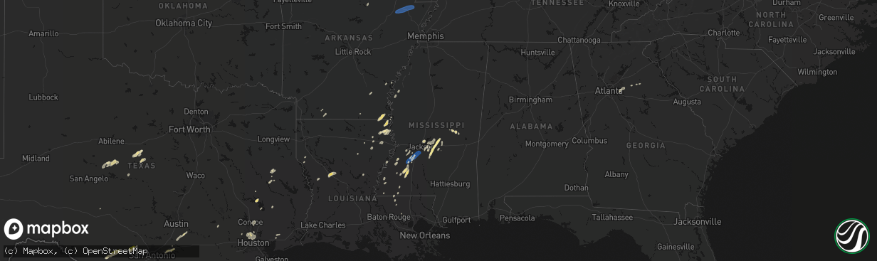
Wind
Hail
1,221
Estimated number of impacted properties by a 1.00" hail or larger0
Estimated number of impacted properties by a 1.75" hail or larger0
Estimated number of impacted properties by a 2.50" hail or largerStorm reports in Mississippi
Mississippi
| Date | Description |
|---|---|
| 03/07/20264:57 PM CST | Corrects previous tstm wnd dmg report from 3 ene carthage. Emergency management reported a few trees down between carthage and edinburg. |
| 03/07/20264:38 PM CST | Trees were downed along harrell rd and leesburg rd. |
| 03/07/20264:30 PM CST | Metal siding on the roof came up. A few trees were split. |
| 03/07/20264:28 PM CST | Small trees snapped and large tree limbs snapped off along morton rankin county line road. |
| 03/07/20264:23 PM CST | Trees downed along noblin bridge rd. |
| 03/07/20264:15 PM CST | Tree downed across joe coker rd near coker cir. |
| 03/07/20264:05 PM CST | Report of downed tree. |
| 03/07/20264:00 PM CST | Trees downed along ms hwy 18 between brandon and puckett. |
| 03/07/20263:57 PM CST | Emergency management reported a few trees down between carthage and edinburg. |
| 03/07/20263:56 PM CST | Report of multiple trees downed across the city of terry/byram. |
| 03/07/20263:54 PM CST | A couple trees were downed on stump bridge rd. |
| 03/07/20263:51 PM CST | A tree was downed at us 51 and davis crossing rd. |
| 03/07/20263:46 PM CST | Report of quarter sized hail and 70mph gusts from hand held anemometer. |
| 03/07/20263:31 PM CST | Corrects previous tstm wnd dmg report from 2 sw leesburg. Trees down on rehobeth rd. |
| 03/07/20263:30 PM CST | Trees down on rehobeth rd. |
| 03/07/20263:21 PM CST | Law enforcement reported multiple trees down near hwy 43 n hux hill and 174 old westville within the pinola area. |
| 03/07/20263:19 PM CST | Tree downed on powerline near the 790 block of coal bluff rd... Causing the powerline to fall to the ground. Also a transformer blew and on fire and as well as trees do |
| 03/07/20263:15 PM CST | Peak wind gust of 64 mph measured with a handheld anemometer west of gallman. |
| 03/07/20262:45 PM CST | Report of damage to church roof... Multiple downed tree limbs... Home damaged by downed powerlines... And some small electrical fires. |
| 03/07/20261:30 PM CST | Report of trees down around the county and some transformers blown. |
| 03/07/202611:07 AM CST | Tree down at pleasant hill and laughter road resulting in a power outage. |
| 03/07/202611:05 AM CST | Strong winds knocked down a few fences and a storage shed north of lewisburg schools off craft road. |
All States Impacted by Hail Map on March 7, 2026
Cities Impacted by Hail Map on March 7, 2026
- Ballinger, TX
- Winters, TX
- Talpa, TX
- Coleman, TX
- Novice, TX
- Mount Pleasant, AR
- Doniphan, MO
- Naylor, MO
- Rising Star, TX
- Brownwood, TX
- Comanche, TX
- Carbon, TX
- Junction, TX
- Santa Anna, TX
- May, TX
- Blanket, TX
- Sidney, TX
- Brookesmith, TX
- Alicia, AR
- Walnut Ridge, AR
- Jonesboro, AR
- Cash, AR
- Weiner, AR
- Bono, AR
- State University, AR
- Bay, AR
- Brookland, AR
- Lake City, AR
- Black Oak, AR
- Transylvania, LA
- Magnolia, AR
- Circleville, OH
- Ashville, OH
- Lake Providence, LA
- Watson, AR
- Stoutsville, OH
- Amanda, OH
- Lancaster, OH
- Carroll, OH
- Pleasantville, OH
- Emerson, AR
- Monticello, AR
- Thornville, OH
- Rushville, OH
- Baltimore, OH
- Heath, OH
- Nashport, OH
- Newark, OH
- Frazeysburg, OH
- Carrollton, OH
- Mechanicstown, OH
- Cleveland, MS
- Delhi, LA
- Dresden, OH
- Crossett, AR
- Salineville, OH
- Kensington, OH
- Summitville, OH
- Lisbon, OH
- Panama, NY
- Clymer, NY
- Sherman, NY
- Tallulah, LA
- Walker, LA
- Benoit, MS
- Winnsboro, LA
- Bremen, OH
- Somerset, OH
- Mount Perry, OH
- Roseville, OH
- Ashville, NY
- Mayville, NY
- Bemus Point, NY
- Stow, NY
- Jamestown, NY
- Eudora, AR
- Oak Grove, LA
- Douglass, TX
- Greenville, MS
- Nacogdoches, TX
- Dellroy, OH
- Bowerston, OH
- Sherrodsville, OH
- Jones, LA
- Parkdale, AR
- Natchez, MS
- Ellwood City, PA
- Fombell, PA
- Portersville, PA
- Harmony, PA
- Prospect, PA
- Butler, PA
- Koppel, PA
- Darlington, PA
- New Galilee, PA
- Beaver Falls, PA
- Wampum, PA
- Wilson, LA
- Epps, LA
- Pioneer, LA
- Baskin, LA
- Rayville, LA
- Wilmot, AR
- Clinton, LA
- Belmont, OH
- Bellaire, OH
- Jacobsburg, OH
- Saint Clairsville, OH
- Neffs, OH
- McCall Creek, MS
- Liberty, MS
- West Sunbury, PA
- Chicora, PA
- Titusville, PA
- Centreville, MS
- Lithonia, GA
- Snellville, GA
- Loganville, GA
- Pleasantville, PA
- Cooperstown, PA
- Bridgeport, OH
- Wheeling, WV
- Karns City, PA
- Petrolia, PA
- Parker, PA
- Gerry, NY
- Sinclairville, NY
- Falconer, NY
- Kennedy, NY
- Conewango Valley, NY
- Cherry Creek, NY
- Cattaraugus, NY
- Randolph, NY
- Little Valley, NY
- Rimersburg, PA
- Sligo, PA
- New Bethlehem, PA
- Triadelphia, WV
- Valley Grove, WV
- Brookhaven, MS
- Union Church, MS
- Endeavor, PA
- West Hickory, PA
- Tidioute, PA
- Meadville, MS
- East Hickory, PA
- Uvalde, TX
- Mayersville, MS
- Gloster, MS
- Norwood, LA
- Vina, AL
- Conyers, GA
- Hodges, AL
- Lufkin, TX
- Hazlehurst, MS
- Wesson, MS
- Tionesta, PA
- Brenham, TX
- Oil City, PA
- Lorman, MS
- Amory, MS
- Fairmount City, PA
- Clarion, PA
- Summerville, PA
- Mayport, PA
- Strattanville, PA
- Corsica, PA
- Brookville, PA
- Columbia, LA
- Port Gibson, MS
- Pattison, MS
- Mansfield, LA
- Waterproof, LA
- Crystal Springs, MS
- Hermanville, MS
- Monroe, GA
- Utopia, TX
- Sabinal, TX
- Pollok, TX
- Knippa, TX
- Concan, TX
- Dothan, AL
- Ashford, AL
- Utica, MS
- Saint Joseph, LA
- Brockway, PA
- Falls Creek, PA
- Reynoldsville, PA
- Penfield, PA
- Brockport, PA
- Kersey, PA
- Weedville, PA
- Ridgway, PA
- Byrnedale, PA
- Saint Marys, PA
- Benezett, PA
- Terry, MS
- Florence, MS
- Byram, MS
- Mendenhall, MS
- Braxton, MS
- Raymond, MS
- Bogart, GA
- Groveton, TX
- Jackson, KY
- Brandon, MS
- Hondo, TX
- Huntsville, TX
- Oakhurst, TX
- Woodville, MS
- Watkinsville, GA
- Athens, GA
- Haleyville, AL
- Edwards, MS
- Bandera, TX
- Jonesville, LA
- Trinity, TX
- Pelahatchie, MS
- Madison, MS
- Ridgeland, MS
- Jackson, MS
- Bradenton, FL
- Florien, LA
- Livingston, LA
- Pearl, MS
- Morton, MS
- Lockhart, TX
- Forest, MS
- Lena, MS
- Natchez, LA
- Natchitoches, LA
- Cloutierville, LA
- Pipe Creek, TX
- Coldspring, TX
- Houston, TX
- Crosby, MS
- Philadelphia, MS
- Cypress, TX
- Dale, TX
- Pulaski, MS
- Spring, TX
- Red Rock, TX
- Conroe, TX
- Punta Gorda, FL
- Union, MS
- Montgomery, LA
- Livingston, TX
- Cleveland, TX
- Bastrop, TX
- Cedar Creek, TX
- Jourdanton, TX
- Charlotte, TX
- Humble, TX
- San Antonio, TX
- Martins Ferry, OH
- Dillonvale, OH
- Tilden, TX
- Seguin, TX
- Calliham, TX
- Auburn, AL
- Laredo, TX
- Mineral City, OH
- New Philadelphia, OH
- Dennison, OH
- Kingsbury, TX
- Clarks Mills, PA
- Fredonia, PA
- Greenville, PA
- Transfer, PA
- Hadley, PA
- Stoneboro, PA
- Sheakleyville, PA
- Cochranton, PA
- Carlton, PA
- Sandy Lake, PA
- Utica, PA
- Franklin, PA
- Freer, TX
- George West, TX
- San Diego, TX
- San Ygnacio, TX
- Zapata, TX
- Roma, TX
- Water Valley, KY
- Wingo, KY
- Mayfield, KY
- Sedalia, KY
- Farmington, KY
- Rio Grande City, TX
- Garciasville, TX
- Grulla, TX
- Devers, TX
- Gulf Breeze, FL
- Wallisville, TX
- Liberty, TX
- Pittsburgh, PA
- Verona, PA
- New Kensington, PA
- Apollo, PA
- Avonmore, PA
- Murrysville, PA
- Spring Church, PA
- West Lebanon, PA
- Saltsburg, PA
- Indiana, PA
- Shelocta, PA
- Home, PA
- Creekside, PA
- Marion Center, PA
- Glen Campbell, PA
- Mahaffey, PA
- Curwensville, PA
- Gipsy, PA
- Rochester Mills, PA
- Rossiter, PA
- Hillsdale, PA
- Clymer, PA
- Commodore, PA
- Irwin, PA
- Latrobe, PA
- Jeannette, PA
- Adamsburg, PA
- Greensburg, PA
- Bovard, PA
- Benton, KY
- Hickory, KY
- Symsonia, KY
- Almo, KY
- Murray, KY
- Dexter, KY
- Cadiz, KY
- Gracey, KY
- Hopkinsville, KY


