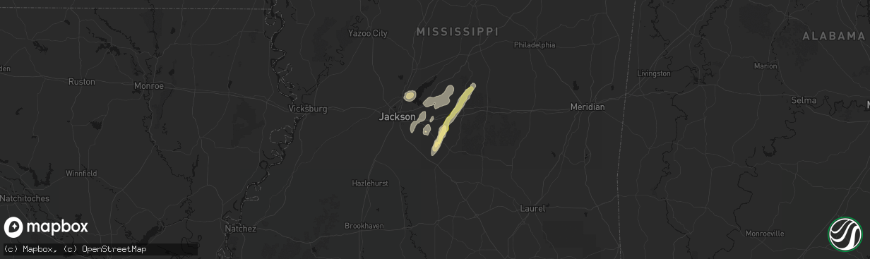
Hail Map in Brandon, MS on March 7, 2026
The weather event in Brandon, MS on March 7, 2026 includes Wind and Hail maps. 13 states and 333 cities were impacted and suffered possible damage. The total estimated number of properties impacted is 144.
Wind
Hail
144
Estimated number of impacted properties by a 1.00" hail or larger0
Estimated number of impacted properties by a 1.75" hail or larger0
Estimated number of impacted properties by a 2.50" hail or largerStorm reports in Brandon, MS
Brandon, MS
| Date | Description |
|---|---|
| 03/07/20264:00 PM CST | Trees downed along ms hwy 18 between brandon and puckett. |
| 03/07/20263:19 PM CST | Tree downed on powerline near the 790 block of coal bluff rd... Causing the powerline to fall to the ground. Also a transformer blew and on fire and as well as trees do |
All States Impacted by Hail Map on March 7, 2026
All Cities Impacted by Hail Map on March 7, 2026
- Ballinger, TX
- Winters, TX
- Talpa, TX
- Coleman, TX
- Novice, TX
- Mount Pleasant, AR
- Doniphan, MO
- Naylor, MO
- Rising Star, TX
- Brownwood, TX
- Comanche, TX
- Carbon, TX
- Junction, TX
- Santa Anna, TX
- May, TX
- Blanket, TX
- Sidney, TX
- Brookesmith, TX
- Alicia, AR
- Walnut Ridge, AR
- Jonesboro, AR
- Cash, AR
- Weiner, AR
- Bono, AR
- State University, AR
- Bay, AR
- Brookland, AR
- Lake City, AR
- Black Oak, AR
- Transylvania, LA
- Magnolia, AR
- Circleville, OH
- Ashville, OH
- Lake Providence, LA
- Watson, AR
- Stoutsville, OH
- Amanda, OH
- Lancaster, OH
- Carroll, OH
- Pleasantville, OH
- Emerson, AR
- Monticello, AR
- Thornville, OH
- Rushville, OH
- Baltimore, OH
- Heath, OH
- Nashport, OH
- Newark, OH
- Frazeysburg, OH
- Carrollton, OH
- Mechanicstown, OH
- Cleveland, MS
- Delhi, LA
- Dresden, OH
- Crossett, AR
- Salineville, OH
- Kensington, OH
- Summitville, OH
- Lisbon, OH
- Panama, NY
- Clymer, NY
- Sherman, NY
- Tallulah, LA
- Walker, LA
- Benoit, MS
- Winnsboro, LA
- Bremen, OH
- Somerset, OH
- Mount Perry, OH
- Roseville, OH
- Ashville, NY
- Mayville, NY
- Bemus Point, NY
- Stow, NY
- Jamestown, NY
- Eudora, AR
- Oak Grove, LA
- Douglass, TX
- Greenville, MS
- Nacogdoches, TX
- Dellroy, OH
- Bowerston, OH
- Sherrodsville, OH
- Jones, LA
- Parkdale, AR
- Natchez, MS
- Ellwood City, PA
- Fombell, PA
- Portersville, PA
- Harmony, PA
- Prospect, PA
- Butler, PA
- Koppel, PA
- Darlington, PA
- New Galilee, PA
- Beaver Falls, PA
- Wampum, PA
- Wilson, LA
- Epps, LA
- Pioneer, LA
- Baskin, LA
- Rayville, LA
- Wilmot, AR
- Clinton, LA
- Belmont, OH
- Bellaire, OH
- Jacobsburg, OH
- Saint Clairsville, OH
- Neffs, OH
- McCall Creek, MS
- Liberty, MS
- West Sunbury, PA
- Chicora, PA
- Titusville, PA
- Centreville, MS
- Lithonia, GA
- Snellville, GA
- Loganville, GA
- Pleasantville, PA
- Cooperstown, PA
- Bridgeport, OH
- Wheeling, WV
- Karns City, PA
- Petrolia, PA
- Parker, PA
- Gerry, NY
- Sinclairville, NY
- Falconer, NY
- Kennedy, NY
- Conewango Valley, NY
- Cherry Creek, NY
- Cattaraugus, NY
- Randolph, NY
- Little Valley, NY
- Rimersburg, PA
- Sligo, PA
- New Bethlehem, PA
- Triadelphia, WV
- Valley Grove, WV
- Brookhaven, MS
- Union Church, MS
- Endeavor, PA
- West Hickory, PA
- Tidioute, PA
- Meadville, MS
- East Hickory, PA
- Uvalde, TX
- Mayersville, MS
- Gloster, MS
- Norwood, LA
- Vina, AL
- Conyers, GA
- Hodges, AL
- Lufkin, TX
- Hazlehurst, MS
- Wesson, MS
- Tionesta, PA
- Brenham, TX
- Oil City, PA
- Lorman, MS
- Amory, MS
- Fairmount City, PA
- Clarion, PA
- Summerville, PA
- Mayport, PA
- Strattanville, PA
- Corsica, PA
- Brookville, PA
- Columbia, LA
- Port Gibson, MS
- Pattison, MS
- Mansfield, LA
- Waterproof, LA
- Crystal Springs, MS
- Hermanville, MS
- Monroe, GA
- Utopia, TX
- Sabinal, TX
- Pollok, TX
- Knippa, TX
- Concan, TX
- Dothan, AL
- Ashford, AL
- Utica, MS
- Saint Joseph, LA
- Brockway, PA
- Falls Creek, PA
- Reynoldsville, PA
- Penfield, PA
- Brockport, PA
- Kersey, PA
- Weedville, PA
- Ridgway, PA
- Byrnedale, PA
- Saint Marys, PA
- Benezett, PA
- Terry, MS
- Florence, MS
- Byram, MS
- Mendenhall, MS
- Braxton, MS
- Raymond, MS
- Bogart, GA
- Groveton, TX
- Jackson, KY
- Brandon, MS
- Hondo, TX
- Huntsville, TX
- Oakhurst, TX
- Woodville, MS
- Watkinsville, GA
- Athens, GA
- Haleyville, AL
- Edwards, MS
- Bandera, TX
- Jonesville, LA
- Trinity, TX
- Pelahatchie, MS
- Madison, MS
- Ridgeland, MS
- Jackson, MS
- Bradenton, FL
- Florien, LA
- Livingston, LA
- Pearl, MS
- Morton, MS
- Lockhart, TX
- Forest, MS
- Lena, MS
- Natchez, LA
- Natchitoches, LA
- Cloutierville, LA
- Pipe Creek, TX
- Coldspring, TX
- Houston, TX
- Crosby, MS
- Philadelphia, MS
- Cypress, TX
- Dale, TX
- Pulaski, MS
- Spring, TX
- Red Rock, TX
- Conroe, TX
- Punta Gorda, FL
- Union, MS
- Montgomery, LA
- Livingston, TX
- Cleveland, TX
- Bastrop, TX
- Cedar Creek, TX
- Jourdanton, TX
- Charlotte, TX
- Humble, TX
- San Antonio, TX
- Martins Ferry, OH
- Dillonvale, OH
- Tilden, TX
- Seguin, TX
- Calliham, TX
- Auburn, AL
- Laredo, TX
- Mineral City, OH
- New Philadelphia, OH
- Dennison, OH
- Kingsbury, TX
- Clarks Mills, PA
- Fredonia, PA
- Greenville, PA
- Transfer, PA
- Hadley, PA
- Stoneboro, PA
- Sheakleyville, PA
- Cochranton, PA
- Carlton, PA
- Sandy Lake, PA
- Utica, PA
- Franklin, PA
- Freer, TX
- George West, TX
- San Diego, TX
- San Ygnacio, TX
- Zapata, TX
- Roma, TX
- Water Valley, KY
- Wingo, KY
- Mayfield, KY
- Sedalia, KY
- Farmington, KY
- Rio Grande City, TX
- Garciasville, TX
- Grulla, TX
- Devers, TX
- Gulf Breeze, FL
- Wallisville, TX
- Liberty, TX
- Pittsburgh, PA
- Verona, PA
- New Kensington, PA
- Apollo, PA
- Avonmore, PA
- Murrysville, PA
- Spring Church, PA
- West Lebanon, PA
- Saltsburg, PA
- Indiana, PA
- Shelocta, PA
- Home, PA
- Creekside, PA
- Marion Center, PA
- Glen Campbell, PA
- Mahaffey, PA
- Curwensville, PA
- Gipsy, PA
- Rochester Mills, PA
- Rossiter, PA
- Hillsdale, PA
- Clymer, PA
- Commodore, PA
- Irwin, PA
- Latrobe, PA
- Jeannette, PA
- Adamsburg, PA
- Greensburg, PA
- Bovard, PA
- Benton, KY
- Hickory, KY
- Symsonia, KY
- Almo, KY
- Murray, KY
- Dexter, KY
- Cadiz, KY
- Gracey, KY
- Hopkinsville, KY


