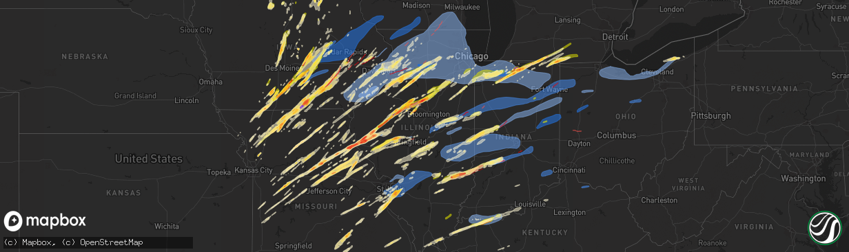
Hail Map in Illinois on March 31, 2023
The weather event in Illinois on March 31, 2023 includes Hail, Wind, and Tornado maps. 19 states and 2,569 cities were impacted and suffered possible damage. The total estimated number of properties impacted is 228,998.
Hail
Wind
Tornado
228,998
Estimated number of impacted properties by a 1.00" hail or larger88,672
Estimated number of impacted properties by a 1.75" hail or larger6,721
Estimated number of impacted properties by a 2.50" hail or largerStorm reports in Illinois
Illinois
| Date | Description |
|---|---|
| 03/31/20236:59 PM CDT | Several farm structures destroyed in far northwest ogle county. Tornado debris signature observed on kdvn radar. |
| 03/31/20236:54 PM CDT | Two buildings damaged; 40x50 shed down and an 80x100 shed with the roof removed. Time estimated from radar. |
| 03/31/20236:54 PM CDT | Spotter observed one inch hail and measured 65 mph gust with a handheld anemometer. |
| 03/31/20236:54 PM CDT | Spotter observed quarter size hail with a few stone slightly smaller than golf balls. |
| 03/31/20236:53 PM CDT | Reported via facebook with picture. |
| 03/31/20236:53 PM CDT | Multiple outbuildings and a detached garage down with siding damage to a house. Time estimated from radar. |
| 03/31/20236:52 PM CDT | Damage to homes from possible tornado. |
| 03/31/20236:50 PM CDT | Met students from niu saw the tornado cross illinois 78 north of town followed by transformer explosions. |
| 03/31/20236:48 PM CDT | Large trees blown down at 1642 olive street in bloomington. |
| 03/31/20236:47 PM CDT | A local report indicates 65 MPH wind near LATHAM |
| 03/31/20236:47 PM CDT | Roof damage to several buildings in latham. |
| 03/31/20236:44 PM CDT | Delayed report... Time estimated from radar. |
| 03/31/20236:42 PM CDT | Corrects previous hail report from 1 wnw swansea. |
| 03/31/20236:42 PM CDT | Delayed report... Time estimated from radar. Report from mping: half dollar |
| 03/31/20236:42 PM CDT | A local report indicates 1.50 inch wind near BELLEVILLE |
| 03/31/20236:42 PM CDT | A local report indicates 1.50 inch wind near 1 WNW SWANSEA |
| 03/31/20236:42 PM CDT | Power pole blown down and tree uprooted in the galva cemetery along hwy 17. |
| 03/31/20236:42 PM CDT | Power poles down. Possible tornado damage. |
| 03/31/20236:41 PM CDT | Delayed report... Time estimated from radar. Report from mping: quarter |
| 03/31/20236:40 PM CDT | Report via facebook with picture. |
| 03/31/20236:39 PM CDT | Report from mping: ping pong ball |
| 03/31/20236:39 PM CDT | A local report indicates 1.50 inch wind near VALMEYER |
| 03/31/20236:39 PM CDT | Delayed report. |
| 03/31/20236:39 PM CDT | A local report indicates 63 MPH wind near N STANFORD |
| 03/31/20236:38 PM CDT | Delayed report. Report from mping: quarter |
| 03/31/20236:38 PM CDT | A local report indicates 1.00 inch wind near 1 ESE BELLEVILLE |
| 03/31/20236:38 PM CDT | Ham radio operator reporting that the fire department on scene of damage near 6 miles ssw of mt. Pulaski. 2 sheds... 2 grain bins damaged. Adjacent home has broken wind |
| 03/31/20236:37 PM CDT | A local report indicates 1.75 inch wind near 3 WNW BELLEVILLE |
| 03/31/20236:37 PM CDT | A local report indicates 1.00 inch wind near 1 ENE VALMEYER |
| 03/31/20236:36 PM CDT | Tornado possible... Detached garage damaged. Several tree limbs down... One window broken in the homes. Damage to farm outbuildings. Time of the event estimated using r |
| 03/31/20236:36 PM CDT | 2 grain bins blown down. Time estimated from radar. |
| 03/31/20236:36 PM CDT | Delayed report. Report from mping: quarter |
| 03/31/20236:34 PM CDT | Possible tornado... Near cemetery. Winds gusting up to 50 mph. Dime size hail. |
| 03/31/20236:30 PM CDT | State police sighted moving east. |
| 03/31/20236:29 PM CDT | Reporting and confirmed by fire department route 36 and washington in dawson hit by tornado. |
| 03/31/20236:28 PM CDT | Heavy damage to structures in sherman by old business 55 by fire station. |
| 03/31/20236:27 PM CDT | 4 power poles broken. Time estimated from radar. |
| 03/31/20236:26 PM CDT | Dawson fpd reporting tornado touchdown on route 36/172 overpass. |
| 03/31/20236:22 PM CDT | Tops snapped out of trees. Estimated winds of 70 to 75 mph. |
| 03/31/20236:20 PM CDT | Roof off of a barn with damage to outbuildings. |
| 03/31/20236:19 PM CDT | Storm chaser reporting a stovepipe tornado touchdown n of taco johns outside of riverton that hit several homes. Saw severe damage on the homes while travelling e on i- |
| 03/31/20236:15 PM CDT | Tornado on ground near country market in sherman. |
| 03/31/20236:13 PM CDT | Limbs down estimated winds of 70 mph. |
| 03/31/20236:13 PM CDT | Report from mping: quarter |
| 03/31/20236:10 PM CDT | Power lines and tree blown down on road at 22219 grosenbach rd. |
| 03/31/20236:10 PM CDT | Power pole and lines blown down at 1817 morris mill road. |
| 03/31/20236:09 PM CDT | Corrected time of wind gust at springfield airport. |
| 03/31/20236:05 PM CDT | I280 at jumers. |
| 03/31/20236:00 PM CDT | Corrects the time of the tstm wnd dmg report from 4 sw eleanor. Tops snapped out of trees. Estimated winds of 70 to 75 mph. |
| 03/31/20236:00 PM CDT | Corrects previous tstm wnd dmg report from seaton. Damage seemed more severe than straight line winds... Missing shingles... Destroyed and damaged outbuildings on the o |
| 03/31/20235:54 PM CDT | Spotter saw what looks like a tornado and power fashes 20 miles wsw of sherman. |
| 03/31/20235:52 PM CDT | Also pea sized hail. |
| 03/31/20235:45 PM CDT | A local report indicates 1.75 inch wind near W PRENTICE |
| 03/31/20235:42 PM CDT | One half mile from morton ave exit on i-72. |
| 03/31/20235:37 PM CDT | Mping of tree damage at location. |
| 03/31/20235:35 PM CDT | Spotter possibly drove through tornado. Said there was strong winds and possible debris as it passed. |
| 03/31/20235:27 PM CDT | Spotter saw tornado on the ground. |
| 03/31/20235:25 PM CDT | A local report indicates 1.25 inch wind near CHAPIN |
| 03/31/20235:02 PM CDT | A local report indicates 1.00 inch wind near 2 N VAN ORIN |
| 03/31/20234:55 PM CDT | A local report indicates 1.75 inch wind near MOUNT STERLING |
| 03/31/20234:53 PM CDT | Corrects previous hail report from 3 nw versailles. Delayed report... Time estimated from radar. |
| 03/31/20234:53 PM CDT | Corrects previous hail report from mount sterling. Delayed report... Time estimated from radar. |
| 03/31/20234:52 PM CDT | A local report indicates 1.75 inch wind near 4 E BUCKHORN |
| 03/31/20234:51 PM CDT | Delayed report. |
| 03/31/20234:50 PM CDT | Delayed report... Time estimated from radar. |
| 03/31/20234:48 PM CDT | Delayed report. Minor roof damage to shingled and metal panel roof. Time estimated from radar. |
| 03/31/20234:48 PM CDT | Delayed report... Time estimated from radar. Open sided car port flipped over. |
| 03/31/20234:46 PM CDT | A local report indicates 1.00 inch wind near MATTESON |
| 03/31/20234:35 PM CDT | Via twitter with pictures. On east 2775th street just north of intersection with illinois route 104. |
| 03/31/20234:34 PM CDT | Confirmed with picture of hail and ruler. |
| 03/31/20234:33 PM CDT | Delayed report. Time estimated by radar. |
| 03/31/20234:30 PM CDT | Time estimated via radar. |
| 03/31/20234:30 PM CDT | A local report indicates 2.50 inch wind near 1 ENE KINGSTON |
| 03/31/20234:27 PM CDT | Corrects previous hail report from kingston. Time estimated. |
| 03/31/20234:25 PM CDT | Cyle dickens nws chat. |
| 03/31/20234:22 PM CDT | A local report indicates 1.50 inch wind near 3 S RICHFIELD |
| 03/31/20234:20 PM CDT | A local report indicates 1.50 inch wind near 1 E RICHFIELD |
| 03/31/20234:15 PM CDT | Report from mping: quarter |
| 03/31/20234:13 PM CDT | A local report indicates 1.00 inch wind near 1 SW KANKAKEE |
| 03/31/20234:11 PM CDT | Time estimated from radar. |
| 03/31/20233:52 PM CDT | Relayed by nws chicago. |
| 03/31/20233:52 PM CDT | Report from mping: quarter |
| 03/31/20233:50 PM CDT | A local report indicates 1.50 inch wind near 1 ENE WEST PEORIA |
| 03/31/20233:44 PM CDT | Relayed by broadcast media. |
| 03/31/20233:42 PM CDT | A local report indicates 1.00 inch wind near 2 S STREATOR |
| 03/31/20233:41 PM CDT | A local report indicates 1.50 inch wind near BENSON |
| 03/31/20233:41 PM CDT | . |
| 03/31/20233:41 PM CDT | Report from mping: quarter |
| 03/31/20233:30 PM CDT | Numerous car windows broken at the eoc. Time estimated. |
| 03/31/20233:30 PM CDT | Time estimated. |
| 03/31/20233:27 PM CDT | A local report indicates 1.75 inch wind near BENSON |
| 03/31/20233:27 PM CDT | . |
| 03/31/20233:26 PM CDT | A local report indicates 1.00 inch wind near ROANOKE |
| 03/31/20233:26 PM CDT | . |
| 03/31/20233:25 PM CDT | Report from mping: hen egg |
| 03/31/20233:23 PM CDT | Report from mping: ping pong ball |
| 03/31/20233:20 PM CDT | A local report indicates 1.00 inch wind near 2 NE ROCK ISLAND |
| 03/31/20233:15 PM CDT | Heavy damage to barns. |
| 03/31/20233:15 PM CDT | A local report indicates 1.75 inch wind near PEORIA HEIGHTS |
| 03/31/20233:15 PM CDT | . |
| 03/31/20233:15 PM CDT | Heavy damage to barns. |
| 03/31/20233:13 PM CDT | A local report indicates 1.00 inch wind near BARTONVILLE |
| 03/31/20233:13 PM CDT | . |
| 03/31/20233:10 PM CDT | A local report indicates 1.00 inch wind near METAMORA |
| 03/31/20233:10 PM CDT | . |
| 03/31/20233:07 PM CDT | Report from mping: quarter |
| 03/31/20233:00 PM CDT | . |
| 03/31/20233:00 PM CDT | A local report indicates 1.75 inch wind near PEORIA HEIGHTS |
| 03/31/20232:56 PM CDT | A local report indicates 1.50 inch wind near 1 E WEST PEORIA |
| 03/31/20232:56 PM CDT | . |
| 03/31/20232:56 PM CDT | . |
| 03/31/20232:56 PM CDT | A local report indicates 2.75 inch wind near BANNER |
| 03/31/20232:55 PM CDT | A local report indicates 1.75 inch wind near 1 E PEORIA INTL AIRPORT |
| 03/31/20232:54 PM CDT | A local report indicates 1.00 inch wind near 2E MORTON |
| 03/31/20232:54 PM CDT | 8010 s trivoli rd. |
| 03/31/20232:52 PM CDT | A local report indicates 1.50 inch wind near 1 E WEST PEORIA |
| 03/31/20232:52 PM CDT | Report from mping: quarter |
| 03/31/20232:49 PM CDT | A local report indicates 1.50 inch wind near BELLEVUE |
| 03/31/20232:49 PM CDT | . |
| 03/31/20232:49 PM CDT | Golfball hail measured. Significant windshield damage to vehicles. Multiple cars damaged requiring towing from the roadway due to hail. |
| 03/31/20232:42 PM CDT | A local report indicates 1.00 inch wind near 2 E MORTON |
| 03/31/20232:42 PM CDT | . |
| 03/31/20232:37 PM CDT | Corrects previous tornado report from manito. Location updated to be 5.5 miles nw of manito. No ef rating is available at this time. Brief tornado touchdown near the in |
| 03/31/20232:37 PM CDT | Corrects previous tornado report from manito. No ef rating is available at this time. Brief tornado touchdown near the intersection of state park rd and spring lake rd. |
| 03/31/20232:37 PM CDT | One inch hail measured by a trained spotter in hanna city... Il. |
| 03/31/20232:11 PM CDT | Report of damaged siding and window frames due to hail. Hail size is unknown at the location. Surrounding reports were around one inch. |
| 03/31/20231:31 PM CDT | Report from mping: quarter |
| 03/31/20231:30 PM CDT | Time estimated by radar. |
| 03/31/20231:30 PM CDT | Public report relayed by broadcast media. |
| 03/30/202310:55 PM CDT | A local report indicates 60 MPH wind near GRAYVILLE |
| 03/30/202310:15 PM CDT | A local report indicates 60 MPH wind near 3 N BELLE PRAIRIE CITY |
| 03/30/202310:02 PM CDT | Farmstead with heavy damage at il-49 and 3900 n rd. |
| 03/30/20239:37 PM CDT | Tree limbs down. Pieces of sheet metal blown around. Wind gusts estimated 60-65 mph. Time estimated from radar. |
| 03/30/20239:13 PM CDT | Corrects previous tornado report from 1 e robinson. Tornado a half mile south of the intersection of highway 1 and 33 east side of robinson. Two homes destroyed and pow |
| 03/30/20239:13 PM CDT | Tornado near intersection of highway 1 and 33 east side of robinson. |
| 03/30/20239:10 PM CDT | Pea sized hail also occurred. |
| 03/30/20238:58 PM CDT | A local report indicates 67 MPH wind near COLES COUNTY AIRPORT |
| 03/30/20238:50 PM CDT | Roads blocked by downed lines in effingham. Time estimated from radar. |
| 03/30/20238:50 PM CDT | Report from mping: quarter |
| 03/30/20238:47 PM CDT | Two power poles blown down near 750 north road. |
| 03/30/20238:46 PM CDT | Wires down at theodore and cedarwood. |
| 03/30/20238:40 PM CDT | Pickup truck and motor home trapped by downed power lines along route 49 south of highway 36. |
| 03/30/20238:40 PM CDT | A local report indicates 61 MPH wind near PEOTONE |
| 03/30/20238:35 PM CDT | Reported at the hospital in hoopeston. |
| 03/30/20238:30 PM CDT | Large weighted patio table blown into two trucks... Damaging them. |
| 03/30/20238:30 PM CDT | A local report indicates 60 MPH wind near 3.0 SW MIDWAY AIRPORT |
| 03/30/20238:27 PM CDT | Report from brent collins... Chief of the volunteer fd. Damage seemed more severe than straight line winds... Missing shingles... Destroyed and damaged outbuildings on |
| 03/30/20238:27 PM CDT | A local report indicates 1.00 inch wind near 1 S NORRIS CITY |
| 03/30/20238:25 PM CDT | Wind damage to a large greenhouse at shawnee community college east of ullin il. Report relayed by wsil-tv. Time estimated from radar. |
| 03/30/20238:22 PM CDT | Wires downed on riverside drive in mchenry. Time estimated from radar. |
| 03/30/20238:20 PM CDT | Wires down. Potential tornado damage. |
| 03/30/20238:20 PM CDT | Approximately 12 inch diameter tree trunk uprooted. Many small to medium size branches also downed in the area. |
| 03/30/20238:20 PM CDT | Several trees down in the small town of perks. |
| 03/30/20238:20 PM CDT | Station il-cp-108 urbana 2.3 sse. |
| 03/30/20238:20 PM CDT | Measured at lemont eoc. |
| 03/30/20238:20 PM CDT | A local report indicates 73 MPH wind near 2 SE URBANA |
| 03/30/20238:18 PM CDT | Shingles blown off building. |
| 03/30/20238:18 PM CDT | Large sections of roofing removed southwest of flatville. |
| 03/30/20238:17 PM CDT | Corrects previous tstm wnd dmg report from 2 wsw wellington. Tool shed tossed and tree down. Potential tornado damage. Time estimated from radar. |
| 03/30/20238:17 PM CDT | Corrects previous tstm wnd dmg report from 1 w lemont. Semi blown over on i-355 on lemont bridge crossing of the desplaines river. |
| 03/30/20238:17 PM CDT | Wires down. Potential tornado damage. |
| 03/30/20238:16 PM CDT | Awos observation from greenville airport. |
| 03/30/20238:15 PM CDT | At kc09 morris airport awos station. |
| 03/30/20238:15 PM CDT | Champaign airport measured 71 mph wind gust from thunderstorm. |
| 03/30/20238:14 PM CDT | Delayed report. Time estimated from radar. |
| 03/30/20238:14 PM CDT | Corrects previous tstm wnd gst report from nws chicago-romeoville. Measured at wfo chicago-romeoville... Il. |
| 03/30/20238:14 PM CDT | Measured at wfo chicago-romeoville... Il. |
| 03/30/20238:13 PM CDT | Corrects previous tstm wnd dmg report from 2 nnw plainfield. 135th st and rt. 30. Shingles blown off... Patio furniture blown up over the house. |
| 03/30/20238:13 PM CDT | 64.4 wind gusts and pea sized hail. |
| 03/30/20238:12 PM CDT | Tree downed. Time estimated from radar. |
| 03/30/20238:11 PM CDT | Corrects previous tstm wnd dmg report from 2 wnw romeoville. I-55 near weber road - semi-blown over on i-55. |
| 03/30/20238:10 PM CDT | Possible tornado. Funnel cloud sighted. Mangled sheet metal debris in field with downed power lines. |
| 03/30/20238:10 PM CDT | Tree downed. Time estimated from radar. |
| 03/30/20238:10 PM CDT | Four large elm trees downed. |
| 03/30/20238:10 PM CDT | Machine shed destroyed along il route 1 and iroquois county road. Possible tornado. |
| 03/30/20238:09 PM CDT | Private weather station recorded. |
| 03/30/20238:06 PM CDT | Measured at a davis weather station. Large pine tree downed and multiple air conditioning units blown over near meadow lane and 135th st. |
| 03/30/20238:06 PM CDT | A local report indicates 61 MPH wind near SCOTT AFB |
| 03/30/20238:05 PM CDT | Em relayed report that tornado crossed il route 9 by a person driving down that road. |
| 03/30/20238:05 PM CDT | Oak tree fell onto the roof of a house in aurora. Time estimated from radar. |
| 03/30/20238:05 PM CDT | Corrects time of previous wind damage report from 6 nne harvard. Tree damage reported at alden rd and state line rd. |
| 03/30/20238:01 PM CDT | Reports of extensive wind damage from main/wilson streets south towards walnut street and east across the fox river. Most concentrated area of damage on elm street wher |
| 03/30/20238:01 PM CDT | Corrects previous wind damage report from harvard. Tree damage reported in harvard. Time estimated from radar. |
| 03/30/20238:01 PM CDT | Tree downed onto a house in harvard. Time estimated from radar. |
| 03/30/20238:00 PM CDT | Strong winds caused damage to a residential corrugated steel garage door. |
| 03/30/20238:00 PM CDT | Main power pole snapped in half blocking road in the area of 23500 block of streit road. |
| 03/30/20237:58 PM CDT | Spotter estimate a 60 mph gust at the leading edge of the line of thunderstorms. |
| 03/30/20237:58 PM CDT | Wires downed near herget middle school in aurora. Time estimated from radar. |
| 03/30/20237:58 PM CDT | Report from mping: half dollar |
| 03/30/20237:58 PM CDT | Semi blown over on i-88 northwest of aurora. |
| 03/30/20237:53 PM CDT | Multiple reports of damage... Mainly to trees... In the vicinity of dickson and galena roads. Damage continues ene towards montgomery. |
| 03/30/20237:53 PM CDT | A local report indicates 1.00 inch wind near MOUNT ZION |
| 03/30/20237:53 PM CDT | Aurora asos measured 64 mph. |
| 03/30/20237:51 PM CDT | A local report indicates 1.25 inch wind near SE MOUNT ZION |
| 03/30/20237:50 PM CDT | *** 1 fatal... 24 inj *** corrects previous tstm wnd dmg report from belvidere. Fire department reported relayed via local news media of a roof collapse during at conce |
| 03/30/20237:48 PM CDT | Em reports roof collapse on a building at 104 north state street. Possible tornado damage. |
| 03/30/20237:47 PM CDT | Delayed report. Time estimated from radar. Report from mping: 3-inch tree limbs broken; power poles broken. |
| 03/30/20237:47 PM CDT | Corrects previous tstm wnd dmg report from 1 wsw hillsboro. Several trees uprooted and snapped at oak groves cemetery... Some snapped 12ft off the ground. |
| 03/30/20237:47 PM CDT | Tree damage and minor garage roof damage also reported. |
| 03/30/20237:46 PM CDT | Asos wind gust at st. Louis regional airport. |
| 03/30/20237:46 PM CDT | Trained spotter reported tornado illuminated by lightning in the caledonia and poplar grove area. Tornado debris signature observed on kmkx radar. |
| 03/30/20237:45 PM CDT | Bus blown over on i-57 1 mile sw of ludlow. 32 passengers... 2 minor injuries. |
| 03/30/20237:44 PM CDT | A local report indicates 1.00 inch wind near RANTOUL |
| 03/30/20237:44 PM CDT | Uprooted tree at logan pl. Reported via facebook from local law enforcement. Time estimated via radar. |
| 03/30/20237:44 PM CDT | Private weather station recorded 64 mph. |
| 03/30/20237:42 PM CDT | A local report indicates 1.00 inch wind near 3 S STONINGTON |
| 03/30/20237:42 PM CDT | Roof damage and trees down in the bucknell subdivision near old river road and north main. |
| 03/30/20237:41 PM CDT | Private weather station north of leland. |
| 03/30/20237:41 PM CDT | Tree snapped at the base... Report via facebook from local law enforcement. Time estimated from radar. |
| 03/30/20237:39 PM CDT | Large tree downed and blocking roadway. Power lines also downed. |
| 03/30/20237:39 PM CDT | Nw earlville private weather station measured north of meridian. |
| 03/30/20237:38 PM CDT | Illini fs damaged by a tornado along routhe 136 southeast of dewey. |
| 03/30/20237:38 PM CDT | Report from mping: half dollar |
| 03/30/20237:38 PM CDT | Damage reported via facebook of a grain silo damaged and collapsed outbuilding. Time estimated via radar. |
| 03/30/20237:35 PM CDT | Krpj asos peak gust. |
| 03/30/20237:35 PM CDT | Several trees down. |
| 03/30/20237:33 PM CDT | A local report indicates 1.00 inch wind near N TAYLORVILLE |
| 03/30/20237:30 PM CDT | Power poles snapped along roosevelt dr.... Picture via facebook and time estimated from radar. |
| 03/30/20237:29 PM CDT | Several trees down at a camp site near tower rd and la moille rd near woodhaven lakes. |
| 03/30/20237:27 PM CDT | Machine shed destroyed... Time estimated via radar. |
| 03/30/20237:27 PM CDT | 10ft x 10ft shed pulled out of the ground... Flipped... And moved 20 ft. Time estimated from radar. |
| 03/30/20237:25 PM CDT | Power poles downed plank road near the lasalle bureau county border. |
| 03/30/20237:25 PM CDT | A local report indicates 67 MPH wind near AMBOY |
| 03/30/20237:24 PM CDT | Photos shared on social media of two grain bins heavily damaged along with 5 large trees either with their trunks snapped or toppled/uprooted. |
| 03/30/20237:24 PM CDT | Structure damage to roof... Time estimated by radar. |
| 03/30/20237:24 PM CDT | *** 1 fatal... 40 inj *** an nws damage survey confirmed an ef-1 tornado with path length of approximately 28 miles... Maximum width of 900 yards... And peak winds of 9 |
| 03/30/20237:22 PM CDT | Large tree |
| 03/30/20237:22 PM CDT | Two semis blown over on i-39 northeast of mendota. |
| 03/30/20237:21 PM CDT | Several trees and power lines downed in mendota. |
| 03/30/20237:19 PM CDT | A local report indicates 74 MPH wind near SUBLETTE |
| 03/30/20237:18 PM CDT | 5 mobile home trailers with their roofs peeled off |
| 03/30/20237:17 PM CDT | Semi blown over on i-355 on lemont bridge crossing of the desplaines river. |
| 03/30/20237:13 PM CDT | 135th st and rt. 30. Shingles blown off... Patio furniture blown up over the house. |
| 03/30/20237:13 PM CDT | 20 power poles blown down along the taylorville nokomis blacktop south of taylorville toward the power sub-station. |
| 03/30/20237:11 PM CDT | Grain bin damaged at maplehurst farms. Time estimated based on radar. |
| 03/30/20237:11 PM CDT | Destoryed barn photo shared by public to social media... Time estimated on radar. |
| 03/30/20237:11 PM CDT | I-55 near weber road - semi-blown over on i-55. |
| 03/30/20237:07 PM CDT | A local report indicates 64 MPH wind near 4 NNE STOCKTON |
| 03/30/20237:06 PM CDT | Spotter reporting repeated brief touchdowns of small rope tornado n of morrisonville. |
| 03/30/20237:05 PM CDT | Tree damage reported at alden rd and state line rd. |
| 03/30/20237:01 PM CDT | Spotter reporting tornado and debris on telstar and scully rd just e of dawson. |
All States Impacted by Hail Map on March 31, 2023
Cities Impacted by Hail Map on March 31, 2023
- Iola, KS
- Colony, KS
- Welda, KS
- Concordia, MO
- Corder, MO
- Alma, MO
- Blackburn, MO
- Malta Bend, MO
- Miami, MO
- Marshall, MO
- Slater, MO
- Dalton, MO
- Brunswick, MO
- Salisbury, MO
- Clifton Hill, MO
- Mountain Home, AR
- Clarkridge, AR
- Gainesville, MO
- Udall, MO
- Tecumseh, MO
- Bakersfield, MO
- Caulfield, MO
- Worth, MO
- Grant City, MO
- Mount Ayr, IA
- Redding, IA
- Keytesville, MO
- Glasgow, MO
- Huntsville, MO
- Elk Creek, MO
- Yukon, MO
- Houston, MO
- Eunice, MO
- Summersville, MO
- Hartshorn, MO
- Raymondville, MO
- Salem, MO
- Butler, MO
- Jadwin, MO
- Kellerton, IA
- Lamoni, IA
- Grand River, IA
- Perry, MO
- Center, MO
- Monroe City, MO
- Hannibal, MO
- New London, MO
- Osceola, IA
- New Virginia, IA
- Hull, IL
- Plainville, IL
- Payson, IL
- Liberty, IL
- Cosby, MO
- Helena, MO
- Union Star, MO
- Clarksdale, MO
- Amity, MO
- Clayton, IL
- Camp Point, IL
- Pottersville, MO
- West Plains, MO
- Maysville, MO
- Pattonsburg, MO
- Weatherby, MO
- Kincaid, KS
- Everton, AR
- Hatfield, MO
- Parker, KS
- Centerville, KS
- Fontana, KS
- Kirby, AR
- Langley, AR
- Fayette, MO
- Windsor, MO
- Oregon, MO
- Holden, MO
- Centerview, MO
- Odessa, MO
- Stoutsville, MO
- Higbee, MO
- Fillmore, MO
- Excello, MO
- Jacksonville, MO
- Ravenwood, MO
- Sheridan, MO
- Conception Junction, MO
- Stanberry, MO
- Clyde, MO
- Caddo Gap, AR
- Glenwood, AR
- Midway, AR
- Stewartsville, MO
- Coffey, MO
- Moberly, MO
- Garnett, KS
- Piqua, KS
- Neosho Falls, KS
- Lakeview, AR
- Gilliam, MO
- Higginsville, MO
- Yellville, AR
- Flippin, AR
- Bull Shoals, AR
- Perryville, AR
- Blairstown, MO
- Clinton, MO
- Chilhowee, MO
- Leeton, MO
- Timewell, IL
- Pearcy, AR
- Hot Springs National Park, AR
- Royal, AR
- Osborn, MO
- Cameron, MO
- Winston, MO
- Altamont, MO
- Gallatin, MO
- Jameson, MO
- Woodburn, IA
- Knob Noster, MO
- Warrensburg, MO
- La Monte, MO
- Whiteman Air Force Base, MO
- Williamstown, MO
- Saint Patrick, MO
- Kahoka, MO
- Monticello, MO
- Montrose, MO
- Osceola, MO
- Alexandria, MO
- Deepwater, MO
- Rushville, IL
- Astoria, IL
- Vermont, IL
- Hughesville, MO
- Sedalia, MO
- Lorimor, IA
- Macksburg, IA
- Winterset, IA
- Afton, IA
- Thayer, IA
- Lonsdale, AR
- Murray, IA
- Benton, AR
- Lucas, IA
- Lacona, IA
- Milo, IA
- Pleasantville, IA
- Sumner, TX
- Paris, TX
- Houstonia, MO
- Powderly, TX
- Blossom, TX
- Truro, IA
- Ipava, IL
- Lewistown, IL
- Nelson, MO
- Van Wert, IA
- Cuba, IL
- Canton, IL
- Bryant, IL
- Blackwater, MO
- Weldon, IA
- Greenbrier, AR
- Quitman, AR
- Bosworth, MO
- Bogard, MO
- Hale, MO
- Saint David, IL
- Calhoun, MO
- Jamesport, MO
- Gilman City, MO
- Alexander, AR
- Lincoln, MO
- Little Rock, AR
- Spickard, MO
- Trenton, MO
- Princeton, MO
- Lucerne, MO
- Powersville, MO
- Kemp, TX
- Ennis, TX
- Monroe, IA
- Chatfield, TX
- Mabank, TX
- Detroit, TX
- North Little Rock, AR
- Franklin, MO
- New Franklin, MO
- Knoxville, IA
- Tremont, IL
- Swan, IA
- Otley, IA
- Reasnor, IA
- Newton, IA
- Sherwood, AR
- Chariton, IA
- Eustace, TX
- Granger, IA
- Polk City, IA
- Slater, IA
- Sheldahl, IA
- Madrid, IA
- Kelley, IA
- Ames, IA
- Sumner, MO
- Jacksonville, AR
- Trivoli, IL
- Hanna City, IL
- Glasford, IL
- Brookfield, MO
- Mapleton, IL
- Laclede, MO
- Kellogg, IA
- Peoria, IL
- Manito, IL
- Chillicothe, MO
- Kingston Mines, IL
- Unionville, MO
- Seymour, IA
- Centerville, IA
- Mystic, IA
- Morton, IL
- Mackinaw, IL
- Deer Creek, IL
- Broken Bow, OK
- Otterville, MO
- Bunceton, MO
- Bethel, OK
- Mercer, MO
- Corydon, IA
- Gilbert, IA
- Boone, IA
- Cole Camp, MO
- Story City, IA
- Stover, MO
- Florence, MO
- Gilman, IA
- Versailles, MO
- Fortuna, MO
- Syracuse, MO
- Tipton, MO
- Melcher Dallas, IA
- Harrisburg, MO
- Clark, MO
- East Peoria, IL
- Creve Coeur, IL
- Cabot, AR
- Washington, IL
- Peoria Heights, IL
- Edwards, IL
- Austin, AR
- Ward, AR
- Chillicothe, IL
- Mossville, IL
- Cincinnati, IA
- Metamora, IL
- Bucklin, MO
- Moravia, IA
- Roland, IA
- Ethel, MO
- Jewell, IA
- Randall, IA
- Boonville, MO
- Blakesburg, IA
- Unionville, IA
- Wooldridge, MO
- Rocheport, MO
- Albia, IA
- Centralia, MO
- Madison, MO
- Eureka, IL
- Roanoke, IL
- Paris, MO
- La Plata, MO
- Elmer, MO
- Kirksville, MO
- Benson, IL
- Columbia, MO
- Ellsworth, IA
- Radcliffe, IA
- Jamestown, MO
- Prairie Home, MO
- Alden, IA
- Williams, IA
- Ottumwa, IA
- Montour, IA
- Marshalltown, IA
- California, MO
- Toledo, IA
- Tama, IA
- Garwin, IA
- Pella, IA
- Sully, IA
- Lynnville, IA
- Mora, MO
- Minonk, IL
- Gibbs, MO
- Brashear, MO
- Mount Vernon, TX
- Mount Pleasant, TX
- Talco, TX
- Cookville, TX
- Udell, IA
- Mineral Springs, AR
- Saratoga, AR
- Columbus, AR
- Ozan, AR
- Nashville, AR
- Hedrick, IA
- Streator, IL
- Flanagan, IL
- Long Point, IL
- Dana, IL
- Kerens, TX
- Malakoff, TX
- Pontiac, IL
- Graymont, IL
- Cornell, IL
- Wortham, TX
- Richland, TX
- Streetman, TX
- Grinnell, IA
- Searsboro, IA
- Trinidad, TX
- Athens, TX
- Montezuma, IA
- Larue, TX
- Carlisle, AR
- Rio, IL
- Galesburg, IL
- Des Arc, AR
- Kamrar, IA
- Holliday, MO
- Hazen, AR
- Oneida, IL
- Lu Verne, IA
- Algona, IA
- Corwith, IA
- Wesley, IA
- Wyoming, IL
- Speer, IL
- Toulon, IL
- Bradford, IL
- Buda, IL
- Tiskilwa, IL
- Hallsville, MO
- Ollie, IA
- Sigourney, IA
- Auxvasse, MO
- Martinsburg, IA
- Princeton, IL
- Thompson, MO
- Mexico, MO
- McCaskill, AR
- Britt, IA
- Malcom, IA
- Frankston, TX
- Palmyra, MO
- Brooklyn, IA
- Wellsville, MO
- Montgomery City, MO
- Middletown, MO
- Coolidge, TX
- Vandalia, MO
- Mexia, TX
- Bowling Green, MO
- Curryville, MO
- Fairfield, TX
- Harper, IA
- Rush Hill, MO
- Ionia, IA
- New Hampton, IA
- Alta Vista, IA
- Laddonia, MO
- Elma, IA
- Teague, TX
- Benton City, MO
- Martinsburg, MO
- Blackstone, IL
- Charles City, IA
- Colwell, IA
- Wenona, IL
- Rutland, IL
- Orchard, IA
- Osage, IA
- Ancona, IL
- Ransom, IL
- Kinsman, IL
- Dwight, IL
- Garner, IA
- Verona, IL
- Gardner, IL
- Mazon, IL
- Braceville, IL
- Coal City, IL
- Odell, IL
- Louisiana, MO
- Frankford, MO
- Farber, MO
- Barry, IL
- Kinderhook, IL
- Malden, IL
- Milan, MO
- Altona, IL
- Woodhull, IL
- Cambridge, IL
- Bishop Hill, IL
- Galva, IL
- Kewanee, IL
- Annawan, IL
- Sheffield, IL
- Mineral, IL
- Chelsea, IA
- Neponset, IL
- Wyanet, IL
- Manlius, IL
- Walnut, IL
- Keota, IA
- Wellman, IA
- Parnell, IA
- Erie, IL
- Lyndon, IL
- Morrison, IL
- Fenton, IL
- Sterling, IL
- Tinley Park, IL
- Matteson, IL
- Frankfort, IL
- Richton Park, IL
- Bullard, TX
- Flint, TX
- Beecher, IL
- Cedar Lake, IN
- Wynne, AR
- Grant Park, IL
- Lowell, IN
- Crown Point, IN
- Merrillville, IN
- Dyer, IN
- Saint John, IN
- Crete, IL
- Colt, AR
- Arkadelphia, AR
- Kalona, IA
- Oxford, IA
- Donaldson, AR
- Malvern, AR
- Leola, AR
- Spring Valley, IL
- Arlington, IL
- La Moille, IL
- Harvey, IA
- Tracy, IA
- Bussey, IA
- Leighton, IA
- Mendota, IL
- Earlville, IL
- Triumph, IL
- New Sharon, IA
- Leland, IL
- Baylis, IL
- South English, IA
- North English, IA
- Versailles, IL
- Mount Sterling, IL
- Solo, MO
- Tennessee Colony, TX
- Rolla, MO
- Parkin, AR
- Saint James, MO
- Iowa City, IA
- Cuba, MO
- Licking, MO
- Coralville, IA
- Solon, IA
- North Liberty, IA
- Beardstown, IL
- Blairstown, IA
- Luzerne, IA
- Keystone, IA
- Van Horne, IA
- Hebron, IN
- Earle, AR
- Schererville, IN
- Valparaiso, IN
- Hobart, IN
- Wanatah, IN
- Union Mills, IN
- Hanna, IN
- Garrison, IA
- Dysart, IA
- Vinton, IA
- Boone Grove, IN
- Kouts, IN
- West Branch, IA
- Hamlet, IN
- Westville, IN
- Kingsford Heights, IN
- La Porte, IN
- Portage, IN
- Walkerton, IN
- Sheridan, AR
- Prattsville, AR
- Park Forest, IL
- Olympia Fields, IL
- Country Club Hills, IL
- Chicago Heights, IL
- Flossmoor, IL
- Hazel Crest, IL
- Glenwood, IL
- Homewood, IL
- Ohio, IL
- Sublette, IL
- Van Orin, IL
- West Brooklyn, IL
- Compton, IL
- Sullivan, MO
- Frederick, IL
- Virginia, IL
- Arenzville, IL
- Pittsfield, IL
- Griggsville, IL
- Winchester, IL
- Bluffs, IL
- Jacksonville, IL
- Chapin, IL
- Tipton, IA
- Genoa, WI
- Bennett, IA
- Viroqua, WI
- Chaseburg, WI
- Stoddard, WI
- Eureka, MO
- Nebo, IL
- House Springs, MO
- Chesterfield, MO
- Osceola, AR
- Augusta, IL
- La Prairie, IL
- Lomax, IL
- Fisk, MO
- High Ridge, MO
- Muscatine, IA
- Foley, MO
- Saint Charles, MO
- Letts, IA
- Wapello, IA
- Saint Peters, MO
- Hillsboro, MO
- Hamburg, IL
- Sperry, IA
- La Harpe, IL
- Dudley, MO
- Mediapolis, IA
- Marquand, MO
- Wappapello, MO
- West Liberty, IA
- Greenville, MO
- Blytheville, AR
- Valles Mines, MO
- Ballwin, MO
- Plymouth, IL
- Columbus Junction, IA
- Batchtown, IL
- Gladstone, IL
- McGee, MO
- De Soto, MO
- Drummonds, TN
- Kennett, MO
- Lowndes, MO
- New Salem, IL
- Barnhart, MO
- Campbell, MO
- Brussels, IL
- Bonne Terre, MO
- O'Fallon, MO
- Puxico, MO
- Farmington, MO
- Fredericktown, MO
- Piggott, AR
- Hornersville, MO
- Festus, MO
- Broseley, MO
- Golden, IL
- Carthage, IL
- Nichols, IA
- Golden Eagle, IL
- Dallas City, IL
- Burlington, IA
- Carman, IL
- White Hall, AR
- Jefferson, AR
- Sherrill, AR
- Lakeville, IN
- North Liberty, IN
- Plymouth, IN
- Bremen, IN
- South Bend, IN
- Potosi, MO
- Steelville, MO
- Wheatland, IA
- Bourbon, MO
- Clarence, IA
- Lowden, IA
- Wakarusa, IN
- Mishawaka, IN
- Richwoods, MO
- Elkhart, IN
- Texarkana, TX
- Texarkana, AR
- Elberon, IA
- San Pierre, IN
- North Judson, IN
- Calamus, IA
- Knox, IN
- Garland City, AR
- Grovertown, IN
- Munford, TN
- Brighton, TN
- Paw Paw, IL
- Steward, IL
- Ladora, IA
- Hartwick, IA
- Victor, IA
- Belle Plaine, IA
- Marengo, IA
- Covington, TN
- Goshen, IN
- Middle Amana, IA
- Walford, IA
- Norway, IA
- Amana, IA
- Swisher, IA
- Ely, IA
- Fairfax, IA
- Cedar Rapids, IA
- South Amana, IA
- Watkins, IA
- Mount Vernon, IA
- Atkins, IA
- Lisbon, IA
- Newhall, IA
- Marion, IA
- Monticello, IA
- Anamosa, IA
- Toddville, IA
- Hiawatha, IA
- Langworthy, IA
- Shellsburg, IA
- Springville, IA
- Central City, IA
- Palo, IA
- Robins, IA
- Alburnett, IA
- Martelle, IA
- Humphrey, AR
- Wabbaseka, AR
- De Witt, IA
- Delmar, IA
- Charlotte, IA
- Manchester, IA
- Winthrop, IA
- Vining, IA
- Urbana, IA
- Delhi, IA
- Ryan, IA
- Center Point, IA
- Masonville, IA
- Prairieburg, IA
- Hopkinton, IA
- Walker, IA
- Coggon, IA
- La Crosse, WI
- Coon Valley, WI
- Pleasant Plains, IL
- Stuttgart, AR
- Brownsville, TN
- Ripley, TN
- Preston, IA
- Bryant, IA
- Davenport, IA
- Bettendorf, IA
- Pleasant Valley, IA
- Mount Pleasant, IA
- Salem, IA
- West Point, IA
- West Burlington, IA
- Wever, IA
- Danville, IA
- New London, IA
- Middletown, IA
- Turrell, AR
- Stronghurst, IL
- Yarmouth, IA
- Biggsville, IL
- Oquawka, IL
- Gerlaw, IL
- Morning Sun, IA
- Monmouth, IL
- Keithsburg, IL
- Little York, IL
- Mount Union, IA
- Seaton, IL
- New Windsor, IL
- North Henderson, IL
- Aledo, IL
- Oakville, IA
- Alexis, IL
- Nappanee, IN
- New Boston, IL
- Joy, IL
- Lynn Center, IL
- Viola, IL
- Andover, IL
- Alpha, IL
- Ophiem, IL
- Moline, IL
- Winfield, IA
- Geneseo, IL
- Osco, IL
- Taylor Ridge, IL
- Matherville, IL
- Reynolds, IL
- East Moline, IL
- Sherrard, IL
- Colona, IL
- Silvis, IL
- Orion, IL
- Carbon Cliff, IL
- Milan, IL
- Coal Valley, IL
- Illinois City, IL
- Rock Island, IL
- Andalusia, IL
- Blue Grass, IA
- Fruitland, IA
- Buffalo, IA
- Grandview, IA
- Sherman, IL
- Casscoe, AR
- Roe, AR
- Clarendon, AR
- Holly Grove, AR
- Williamsville, IL
- Delaware, IA
- Worthington, IA
- Farley, IA
- Cascade, IA
- Earlville, IA
- Dubuque, IA
- Dyersville, IA
- Durango, IA
- Epworth, IA
- New Vienna, IA
- Sherrill, IA
- Holy Cross, IA
- Cassville, WI
- North Buena Vista, IA
- Luxemburg, IA
- Guttenberg, IA
- Potosi, WI
- Mauston, WI
- Wisconsin Dells, WI
- Adams, WI
- Friendship, WI
- Riverton, IL
- Arkdale, WI
- Saint Anthony, IA
- Clemons, IA
- New Providence, IA
- Union, IA
- Geneva, IA
- Thornton, IA
- Clear Lake, IA
- Meservey, IA
- State Center, IA
- Hamilton, IL
- Gilson, IL
- Columbia, IA
- Ackley, IA
- Iowa Falls, IA
- Nashua, IA
- Dows, IA
- Buckingham, IA
- Traer, IA
- Manhattan, IL
- Collins, IA
- Eddyville, IA
- Grimes, IA
- Dallas Center, IA
- King City, MO
- Albany, MO
- Darlington, MO
- La Belle, MO
- Lewistown, MO
- Clarence, MO
- Mark, IL
- Hennepin, IL
- Granville, IL
- Wells, MN
- New Richland, MN
- Tampico, IL
- Prophetstown, IL
- Wilmington, IL
- Woden, IA
- Titonka, IA
- Buffalo Center, IA
- Sheffield, IA
- Latimer, IA
- Alexander, IA
- Clubb, MO
- Marble Hill, MO
- Glenallen, MO
- Millersville, MO
- Greene, IA
- Indianola, IA
- Warsaw, MO
- Murfreesboro, AR
- Delight, AR
- Lockesburg, AR
- Hampton, IL
- Port Byron, IL
- Le Claire, IA
- Rapids City, IL
- Hillsdale, IL
- Naples, TX
- Rhodes, IA
- Hermann, MO
- Anabel, MO
- Eolia, MO
- Silex, MO
- Novinger, MO
- New Boston, MO
- Green Castle, MO
- Green City, MO
- Humphreys, MO
- Knox City, MO
- Newark, MO
- Steamboat Rock, IA
- Liberty, MO
- Lowpoint, IL
- Holt, MO
- Plattsburg, MO
- Lathrop, MO
- Cainsville, MO
- Lancaster, MO
- Bloomfield, IA
- Atlanta, MO
- Peotone, IL
- Monee, IL
- University Park, IL
- Janesville, IA
- Waverly, IA
- Garland, TX
- Rowlett, TX
- Melrose, IA
- Lovilia, IA
- Vallonia, IN
- Campbellsburg, IN
- Salem, IN
- Scottsburg, IN
- Washburn, IL
- Toluca, IL
- Baxter, IA
- Carrollton, MO
- Quincy, IL
- Royse City, TX
- Rockwall, TX
- Reddick, IL
- Essex, IL
- Gower, MO
- Bremond, TX
- Reagan, TX
- Kosse, TX
- Marlin, TX
- Pekin, IL
- Laredo, MO
- Shannon City, IA
- Harwood, MO
- Nevada, MO
- El Dorado Springs, MO
- Walker, MO
- Rich Hill, MO
- Tyler, TX
- Arp, TX
- Philadelphia, MO
- Emden, MO
- Eddy, TX
- Media, IL
- Kirkwood, IL
- Tatum, TX
- Henderson, TX
- Beckville, TX
- Hamilton, IA
- Gassville, AR
- Atkinson, IL
- Wataga, IL
- Beaufort, MO
- Saint Clair, MO
- Momence, IL
- Faucett, MO
- Dearborn, MO
- Steedman, MO
- Williamsburg, MO
- Portland, MO
- Fulton, MO
- Ackworth, IA
- Galt, MO
- Moulton, IA
- Plano, IA
- Bland, MO
- Belle, MO
- Edina, MO
- Easton, MO
- Appleton City, MO
- Rockville, MO
- Green Ridge, MO
- Johnsonville, IL
- Xenia, IL
- Johnston, IA
- Urbandale, IA
- Clive, IA
- Waukee, IA
- Smithville, OK
- Rattan, OK
- Hatfield, AR
- Watson, OK
- Cove, AR
- Chatsworth, IL
- Cullom, IL
- Novelty, MO
- Marshall, TX
- Murchison, TX
- Flora, IL
- Rinard, IL
- Iuka, IL
- Pickton, TX
- Derby, IA
- Troy, TX
- Moody, TX
- Knoxville, IL
- Exline, IA
- Bethel, MO
- Shelbyville, MO
- Leonard, MO
- Jessieville, AR
- Fouke, AR
- Queen City, TX
- New Blaine, AR
- Chebanse, IL
- Herscher, IL
- Dawson, TX
- Montalba, TX
- Purdon, TX
- Dahinda, IL
- Laura, IL
- Cherry, IL
- Williamsfield, IL
- Troy Grove, IL
- Corsicana, TX
- Powell, TX
- Pollock, MO
- De Kalb, TX
- Lonoke, AR
- Willow Springs, MO
- Cabool, MO
- Blevins, AR
- Prescott, AR
- Rockport, IL
- Durham, MO
- Canton, MO
- Taylor, MO
- Maywood, MO
- Ewing, MO
- La Grange, MO
- Mountain View, MO
- Pomona, MO
- Sweet Springs, MO
- Bellflower, MO
- Tyronza, AR
- Gilmore, AR
- McCrory, AR
- Augusta, AR
- Cherry Valley, AR
- Frenchmans Bayou, AR
- Burlison, TN
- Bassett, AR
- Joiner, AR
- Bonnerdale, AR
- Brookston, TX
- Hurdland, MO
- Baring, MO
- Troup, TX
- Reklaw, TX
- Jacksonville, TX
- Laneville, TX
- Tingley, IA
- Union, MO
- Eminence, MO
- Birch Tree, MO
- Ashdown, AR
- Bethany, MO
- Italy, TX
- Milford, TX
- Maxwell, IA
- Little Rock Air Force Base, AR
- Kankakee, IL
- Wilton, AR
- Okolona, AR
- Antoine, AR
- Friendship, AR
- Amity, AR
- Kingdom City, MO
- Pleasant Hill, IL
- Clarksburg, MO
- New Canton, IL
- Carthage, AR
- Davisville, MO
- Viburnum, MO
- Batavia, IA
- Packwood, IA
- Brashear, TX
- Emory, TX
- Point, TX
- El Paso, IL
- Clifton, IL
- Piper City, IL
- Kempton, IL
- Schell City, MO
- Hayesville, IA
- Richland, IA
- Ridgeway, MO
- Newtown, MO
- Harris, MO
- Promise City, IA
- Kearney, MO
- Louisville, IL
- Clutier, IA
- Leon, IA
- Decatur, IA
- Denver, MO
- Killduff, IA
- Ellston, IA
- Barry, TX
- Frost, TX
- Blooming Grove, TX
- Palestine, TX
- Diagonal, IA
- Saint Joseph, MO
- Tularosa, NM
- Morris, IL
- Sulphur Springs, TX
- Como, TX
- Braidwood, IL
- Smithfield, IL
- Camden, IL
- Urich, MO
- Littleton, IL
- Secor, IL
- Melbourne, IA
- Kilgore, TX
- Chandler, TX
- Brownsboro, TX
- Overton, TX
- Groveland, IL
- Pilot Grove, MO
- Sturgeon, MO
- Smithshire, IL
- Grapevine, AR
- Alamogordo, NM
- Dierks, AR
- Simms, TX
- Saltillo, TX
- New Boston, TX
- Omaha, TX
- Putnam, IL
- Chandlerville, IL
- Concord, IL
- Ashland, IL
- Middlebury, IN
- Bristol, IN
- Almyra, AR
- Marvell, AR
- Valmeyer, IL
- Marianna, AR
- Poplar Grove, AR
- Aubrey, AR
- Waterloo, IL
- Shipshewana, IN
- Howe, IN
- Columbia, IL
- Sturgis, MI
- Lexa, AR
- Belleville, IL
- Millstadt, IL
- O'Fallon, IL
- Fairview Heights, IL
- East Saint Louis, IL
- Gary, TX
- Tenaha, TX
- Joaquin, TX
- Burr Oak, MI
- Bronson, MI
- Hooppole, IL
- Deer Grove, IL
- Harmon, IL
- New Bedford, IL
- Amboy, IL
- Rock Falls, IL
- Milledgeville, IL
- Dixon, IL
- Woosung, IL
- Eldena, IL
- Mount Morris, IL
- Oregon, IL
- Polo, IL
- Watervliet, MI
- Benton Harbor, MI
- Hartford, MI
- Decatur, MI
- Lawrence, MI
- Paw Paw, MI
- Bangor, MI
- Gobles, MI
- Shannon, IL
- Baileyville, IL
- Angola, IN
- Fremont, IN
- Montgomery, MI
- Coldwater, MI
- Reading, MI
- Camden, MI
- Hillsdale, MI
- Pittsford, MI
- Hudson, MI
- Osseo, MI
- Tunica, MS
- Dundee, MS
- Montpelier, IA
- Cordova, IL
- Albany, IL
- Fulton, IL
- Timpson, TX
- Riverside, IA
- Hills, IA
- Bells, TN
- Franklin Grove, IL
- Ashton, IL
- Rochelle, IL
- Chana, IL
- Brickeys, AR
- Platteville, WI
- Lancaster, WI
- Rewey, WI
- Crockett, TX
- Clinton, IL
- Maroa, IL
- Weldon, IL
- Lane, IL
- Dewitt, IL
- Farmer City, IL
- De Land, IL
- Lee, IL
- Mansfield, IL
- Mahomet, IL
- Quincy, MI
- Bellflower, IL
- Fisher, IL
- Litchfield, MI
- Allen, MI
- Kennard, TX
- Dewey, IL
- Thomasboro, IL
- Champaign, IL
- Rantoul, IL
- Mattawan, MI
- Apple Springs, TX
- Robinsonville, MS
- Foosland, IL
- Paxton, IL
- Ludlow, IL
- Rockford, IL
- Byron, IL
- Davis Junction, IL
- Stillman Valley, IL
- Miles, IA
- Saint Louis, MO
- Venice, IL
- Granite City, IL
- Lovejoy, IL
- Madison, IL
- East Carondelet, IL
- Dupo, IL
- Caseyville, IL
- Glen Carbon, IL
- Maryville, IL
- Collinsville, IL
- Holcomb, IL
- Lindenwood, IL
- Cherry Valley, IL
- Roscoe, IL
- Machesney Park, IL
- Monroe Center, IL
- Loves Park, IL
- Caledonia, IL
- Morrisonville, IL
- Palmer, IL
- Taylorville, IL
- Durand, IL
- Leaf River, IL
- German Valley, IL
- Freeport, IL
- Pecatonica, IL
- Forreston, IL
- Winnebago, IL
- Rockton, IL
- Ridott, IL
- Lanark, IL
- Mount Carroll, IL
- Chadwick, IL
- Thomson, IL
- Assumption, IL
- Stonington, IL
- Moweaqua, IL
- Savanna, IL
- Princeton, IA
- Camanche, IA
- Clinton, IA
- Blue Mound, IL
- Macon, IL
- Walcott, IA
- Long Grove, IA
- Eldridge, IA
- Esmond, IL
- Moro, IL
- Bethalto, IL
- Cottage Hills, IL
- East Alton, IL
- Wood River, IL
- Shabbona, IL
- Malta, IL
- Ottawa, IL
- Sheridan, IL
- Waterman, IL
- Serena, IL
- Clare, IL
- Kirkland, IL
- Belvidere, IL
- Dekalb, IL
- Clayton, MI
- Edwardsville, IL
- Hanover, MI
- Jonesville, MI
- Alhambra, IL
- Worden, IL
- Troy, IL
- Hamel, IL
- Dorsey, IL
- New Douglas, IL
- Staunton, IL
- Horton, MI
- Jackson, MI
- Marine, IL
- Lebanon, IL
- Saint Jacob, IL
- Sharon, WI
- Capron, IL
- South Beloit, IL
- Harvard, IL
- Genoa, IL
- Sycamore, IL
- Somonauk, IL
- Garden Prairie, IL
- Poplar Grove, IL
- Kingston, IL
- Hinckley, IL
- Hampshire, IL
- Maple Park, IL
- Marengo, IL
- Sandwich, IL
- Cortland, IL
- Dalton City, IL
- Elburn, IL
- Big Rock, IL
- Sugar Grove, IL
- Plano, IL
- Elgin, IL
- Burlington, IL
- Saint Charles, IL
- Clinton, WI
- Union, IL
- Lake In The Hills, IL
- Woodstock, IL
- Huntley, IL
- Crystal Lake, IL
- Gilberts, IL
- Hernando, MS
- Hillsboro, IL
- Sorento, IL
- Pocahontas, IL
- Panama, IL
- Donnellson, IL
- Highland, IL
- Greenville, IL
- Lake Cormorant, MS
- Freeburg, IL
- Mascoutah, IL
- Scott Air Force Base, IL
- Nesbit, MS
- Horn Lake, MS
- Dundee, IL
- Wonder Lake, IL
- Walworth, WI
- Hebron, IL
- Fontana, WI
- Lake Geneva, WI
- Rankin, IL
- Gifford, IL
- Penfield, IL
- Stockton, IL
- Warren, IL
- Elizabeth, IL
- Cissna Park, IL
- Hoopeston, IL
- Lena, IL
- Nora, IL
- Monroe, WI
- Juda, WI
- McConnell, IL
- Orangeville, IL
- Dakota, IL
- Winslow, IL
- South Wayne, WI
- Browntown, WI
- Brodhead, WI
- Orfordville, WI
- Evansville, WI
- Janesville, WI
- Albany, WI
- Trenton, IL
- Summerfield, IL
- Fillmore, IL
- Coffeen, IL
- Mulberry Grove, IL
- Wellington, IL
- Smithboro, IL
- Kalamazoo, MI
- Delavan, WI
- Elkhorn, WI
- Olive Branch, MS
- Byhalia, MS
- Millington, IL
- Seneca, IL
- Newark, IL
- Yorkville, IL
- Millbrook, IL
- Peru, IL
- Seatonville, IL
- Dalzell, IL
- Ladd, IL
- Utica, IL
- Dover, IL
- La Salle, IL
- Collierville, TN
- Marseilles, IL
- Wedron, IL
- Rossville, TN
- Darien, WI
- Beloit, WI
- Channahon, IL
- Minooka, IL
- Montgomery, IL
- Joliet, IL
- Oswego, IL
- Crest Hill, IL
- Elwood, IL
- Shorewood, IL
- Plainfield, IL
- Lockport, IL
- New Lenox, IL
- Bristol, IL
- Aurora, IL
- Keyesport, IL
- Ramsey, IL
- Breese, IL
- Lemont, IL
- Bolingbrook, IL
- Woodridge, IL
- Naperville, IL
- North Aurora, IL
- Romeoville, IL
- Orland Park, IL
- Mokena, IL
- Batavia, IL
- Palos Park, IL
- Homer Glen, IL
- Hickory Hills, IL
- Cary, IL
- Des Plaines, IL
- Wasco, IL
- Algonquin, IL
- Willowbrook, IL
- Bensenville, IL
- Carpentersville, IL
- La Grange, IL
- Clarendon Hills, IL
- Whitewater, WI
- Mooseheart, IL
- Lyons, IL
- Broadview, IL
- Justice, IL
- Riverside, IL
- Hoffman Estates, IL
- Addison, IL
- La Grange Park, IL
- Warrenville, IL
- Wood Dale, IL
- Maywood, IL
- Wheaton, IL
- Western Springs, IL
- Hanover Park, IL
- Rolling Meadows, IL
- Glendale Heights, IL
- Darien, IL
- Lisle, IL
- Fox River Grove, IL
- Berkeley, IL
- Hillside, IL
- Geneva, IL
- Carol Stream, IL
- Mount Prospect, IL
- Oak Brook, IL
- Melrose Park, IL
- Palos Hills, IL
- River Grove, IL
- Downers Grove, IL
- Park Ridge, IL
- Bellwood, IL
- Avalon, WI
- Forest Park, IL
- Schiller Park, IL
- Medinah, IL
- Stone Park, IL
- Arlington Heights, IL
- Schaumburg, IL
- River Forest, IL
- Itasca, IL
- Elk Grove Village, IL
- Winfield, IL
- Prospect Heights, IL
- Hinsdale, IL
- Villa Park, IL
- Palatine, IL
- Bloomingdale, IL
- West Chicago, IL
- Roselle, IL
- Glenview, IL
- Williams Bay, WI
- Wayne, IL
- Summit Argo, IL
- Lombard, IL
- Westmont, IL
- Brookfield, IL
- Chicago, IL
- Hines, IL
- Bartlett, IL
- South Elgin, IL
- Willow Springs, IL
- Franklin Park, IL
- Glen Ellyn, IL
- Streamwood, IL
- Barrington, IL
- Elmhurst, IL
- Westchester, IL
- Wauconda, IL
- Vernon Hills, IL
- Wheeling, IL
- Lincolnshire, IL
- Grayslake, IL
- Round Lake, IL
- Buffalo Grove, IL
- Ringwood, IL
- Libertyville, IL
- Lake Forest, IL
- Island Lake, IL
- Mundelein, IL
- Lake Zurich, IL
- Fox Lake, IL
- Ingleside, IL
- Mchenry, IL
- Northbrook, IL
- Deerfield, IL
- Twin Lakes, WI
- Gurnee, IL
- Antioch, IL
- Genoa City, WI
- East Troy, WI
- Richmond, IL
- Zion, IL
- Waukegan, IL
- Palmyra, WI
- Bristol, WI
- Trevor, WI
- Spring Grove, IL
- Lake Villa, IL
- Eagle, WI
- Wadsworth, IL
- Springfield, WI
- Rochester, WI
- Salem, WI
- Big Bend, WI
- Burlington, WI
- Muskego, WI
- Silver Lake, WI
- Waukesha, WI
- Franksville, WI
- Mukwonago, WI
- Kansasville, WI
- Pleasant Prairie, WI
- Union Grove, WI
- Waterford, WI
- Wilmot, WI
- Kenosha, WI
- Aviston, IL
- Carlyle, IL
- Milford, IL
- Shobonier, IL
- Vandalia, IL
- Brownstown, IL
- Battle Creek, MI
- Bellevue, MI
- Red Banks, MS
- Bridgeview, IL
- Lake Bluff, IL
- Elmwood Park, IL
- Harwood Heights, IL
- Niles, IL
- North Chicago, IL
- Holly Springs, MS
- Lamar, MS
- Moscow, TN
- Great Lakes, IL
- Highland Park, IL
- Skokie, IL
- Golf, IL
- Winnetka, IL
- Wilmette, IL
- Morton Grove, IL
- Highwood, IL
- Glencoe, IL
- Calumet City, IL
- Hometown, IL
- Chicago Ridge, IL
- South Holland, IL
- Hammond, IN
- Whiting, IN
- Evanston, IL
- Berwyn, IL
- Alsip, IL
- Worth, IL
- Harvey, IL
- Midlothian, IL
- Dolton, IL
- Markham, IL
- Burbank, IL
- Blue Island, IL
- Robbins, IL
- Posen, IL
- Cicero, IL
- Oak Forest, IL
- Evergreen Park, IL
- Oak Lawn, IL
- Palos Heights, IL
- Riverdale, IL
- Kenilworth, IL
- Lincolnwood, IL
- Oak Park, IL
- Crestwood, IL
- Ambia, IN
- Earl Park, IN
- Fowler, IN
- Dieterich, IL
- Saint Elmo, IL
- Eldorado, IL
- Norris City, IL
- Broughton, IL
- Omaha, IL
- Boswell, IN
- Remington, IN
- Goodland, IN
- Oxford, IN
- Brookston, IN
- Carmi, IL
- Otterbein, IN
- Tolono, IL
- Ivesdale, IL
- Savoy, IL
- Philo, IL
- Sadorus, IL
- Urbana, IL
- Mt Zion, IL
- Decatur, IL
- Saint Joseph, IL
- Ogden, IL
- Michigan City, MS
- Winthrop Harbor, IL
- Sturtevant, WI
- Ingraham, IL
- Wheeler, IL
- Newton, IL
- Thornton, IL
- Steger, IL
- East Chicago, IN
- Lansing, IL
- Watson, IL
- Farina, IL
- Mason, IL
- Edgewood, IL
- Altamont, IL
- Saint Peter, IL
- Williamsburg, IA
- Cedar, IA
- Fremont, IA
- Oskaloosa, IA
- Willow Hill, IL
- Gary, IN
- Highland, IN
- Munster, IN
- Griffith, IN
- Lake Station, IN
- Wolcott, IN
- West Liberty, IL
- Oblong, IL
- Chesterton, IN
- Saulsbury, TN
- Chrisman, IL
- Ridge Farm, IL
- Dana, IN
- Cayuga, IN
- Middleton, TN
- Kingman, IN
- Perrysville, IN
- Bolivar, TN
- Southaven, MS
- Robinson, IL
- Stoy, IL
- Hutsonville, IL
- Sullivan, IN
- Palestine, IL
- Merom, IN
- Gates, TN
- Halls, TN
- Alamo, TN
- Friendship, TN
- Shelburn, IN
- Covington, IN
- Crawfordsville, IN
- Veedersburg, IN
- Waynetown, IN
- Hillsboro, IN
- Humboldt, TN
- Manteno, IL
- Bourbonnais, IL
- Michigan City, IN
- New Buffalo, MI
- La Crosse, IN
- Beverly Shores, IN
- Farmersburg, IN
- Lewis, IN
- Hymera, IN
- Jasonville, IN
- Coalmont, IN
- Culver, IN
- New Carlisle, IN
- Rolling Prairie, IN
- Three Oaks, MI
- Mill Creek, IN
- Chalmers, IN
- Reynolds, IN
- Monticello, IN
- Idaville, IN
- Burnettsville, IN
- Delphi, IN
- West Lafayette, IN
- Yeoman, IN
- Logansport, IN
- Walton, IN
- Royal Center, IN
- Monon, IN
- Camden, IN
- New Waverly, IN
- Peru, IN
- Wabash, IN
- Onward, IN
- Mexico, IN
- Twelve Mile, IN
- Corydon, KY
- Clay City, IN
- New Richmond, IN
- Clarks Hill, IN
- Colfax, IN
- Linden, IN
- Darlington, IN
- Lucerne, IN
- Denver, IN
- Perry, OH
- Madison, OH
- Geneva, OH
- Lagro, IN
- Urbana, IN
- Andrews, IN
- Frankfort, IN
- Poland, IN
- Spencer, IN
- Argos, IN
- Bourbon, IN
- Morganfield, KY
- Sturgis, KY
- Evansville, IN
- Henderson, KY
- Robards, KY
- Murray, KY
- Newburgh, IN
- Spottsville, KY
- Reed, KY
- Boonville, IN
- Richland, IN
- Rockport, IN
- Owensboro, KY
- Maceo, KY
- Lewisport, KY
- Grandview, IN
- Gosport, IN
- Ellettsville, IN
- Freedom, IN
- Coal City, IN
- Bowling Green, IN
- Patricksburg, IN
- Huntington, IN
- Paragon, IN
- Stinesville, IN
- Martinsville, IN
- Bloomington, IN
- Paris, TN
- New Paris, IN
- Etna Green, IN
- Milford, IN
- Tippecanoe, IN
- South Whitley, IN
- Warsaw, IN
- Columbia City, IN
- Larwill, IN
- Atwood, IN
- Avilla, IN
- Syracuse, IN
- Kimmell, IN
- Ligonier, IN
- Cromwell, IN
- Winona Lake, IN
- Claypool, IN
- Churubusco, IN
- Mentone, IN
- Kendallville, IN
- Laotto, IN
- North Webster, IN
- Pierceton, IN
- Leesburg, IN
- Wawaka, IN
- Millersburg, IN
- Albion, IN
- Arcola, IN
- Roanoke, IN
- Huntertown, IN
- Fort Wayne, IN
- Auburn, IN
- Garrett, IN
- Leo, IN
- Hawesville, KY
- Tell City, IN
- Cannelton, IN
- Somerville, TN
- Woodburn, IN
- Monroeville, IN
- Hoagland, IN
- New Haven, IN
- Payne, OH
- Spencerville, IN
- Grabill, IN
- Yoder, IN
- Michigantown, IN
- Forest, IN
- Williston, TN
- Thorntown, IN
- Russiaville, IN
- Kokomo, IN
- Sharpsville, IN
- Kempton, IN
- Greentown, IN
- Windfall, IN
- Swayzee, IN
- Converse, IN
- Fairmount, IN
- Jonesboro, IN
- Marion, IN
- Logansport, LA
- Hickory Valley, TN
- Sweetser, IN
- Gas City, IN
- Harlan, IN
- Bruceton, TN
- Camden, TN
- Cecil, OH
- Hicksville, OH
- Sherwood, OH
- Mark Center, OH
- Antwerp, OH
- Defiance, OH
- Paulding, OH
- Hornsby, TN
- New Johnsonville, TN
- Eva, TN
- Waverly, TN
- Philpot, KY
- Rome, IN
- Derby, IN
- Morgantown, IN
- Trafalgar, IN
- Bargersville, IN
- Franklin, IN
- Shelbyville, IN
- Greencastle, IN
- North Salem, IN
- Bainbridge, IN
- Coatesville, IN
- Fillmore, IN
- Ladoga, IN
- Danville, IN
- Roachdale, IN
- Lizton, IN
- Bienville, LA
- Quitman, LA
- Indianapolis, IN
- Pittsboro, IN
- Brownsburg, IN
- Zionsville, IN
- Avon, IN
- Plainfield, IN
- Clayton, IN
- Camby, IN
- Mooresville, IN
- Amo, IN
- West Newton, IN
- Beech Grove, IN
- Greenwood, IN
- Simsboro, LA
- Ruston, LA
- Corunna, IN
- Rome City, IN
- Markle, IN
- Zanesville, IN
- Latty, OH
- Ossian, IN
- McEwen, TN
- Liberty Center, IN
- Van Buren, IN
- Warren, IN
- Bluffton, IN
- Montpelier, IN
- Poneto, IN
- Keystone, IN
- Hartford City, IN
- Decatur, IN
- Craigville, IN
- Castor, LA
- Jamestown, LA
- Chatham, LA
- Choudrant, LA
- Oakwood, OH
- Berne, IN
- Geneva, IN
- Monroe, IN
- Muncie, IN
- Yorktown, IN
- Daleville, IN
- Albany, IN
- Dunkirk, IN
- Eaton, IN
- Bethel Springs, TN
- Henderson, TN
- Ridgeville, IN
- Redkey, IN
- Parker City, IN
- Selma, IN
- Farmland, IN
- Portland, IN
- Winchester, IN
- Needham, IN
- Boggstown, IN
- Eros, LA
- Fairland, IN
- Fountaintown, IN
- Morristown, IN
- Manilla, IN
- Calhoun, LA
- West Monroe, LA
- Erin, TN
- Continental, OH
- Convoy, OH
- Ohio City, OH
- Van Wert, OH
- Selmer, TN
- Wren, OH
- Willshire, OH
- Dickson, TN
- Vanleer, TN
- Salamonia, IN
- Union City, IN
- Fort Recovery, OH
- Adamsville, TN
- Morris Chapel, TN
- Charlotte, TN
- Cumberland Furnace, TN
- Goodell, IA
- Liscomb, IA
- Harmony, MN
- Saint Ansgar, IA
- Niles, MI
- Lime Springs, IA
- Cresco, IA
- Hickory Corners, MI
- Dowling, MI
- Delton, MI
- Topeka, IN
- Fort Atkinson, IA
- West Union, IA
- Springfield, IL
- Cantrall, IL
- Tripoli, IA
- Richland, MI
- Waldorf, MN
- Grand Mound, IA
- Floyd, IA
- Fairfield, IA
- Wayland, IA
- Lockridge, IA
- Saint Olaf, IA
- Elkader, IA
- Maquoketa, IA
- La Porte City, IA
- Albion, IA
- Owaneco, IL
- Pana, IL
- McIntire, IA
- Riceville, IA
- Jesup, IA
- Nashville, MI
- Ferryville, WI
- De Soto, WI
- Walls, MS
- Waterloo, IA
- Dunkerton, IA
- Gilbertville, IA
- Evansdale, IA
- Forest City, IL
- Havana, IL
- Topeka, IL
- Dixon, IA
- Washington, IA
- Saint Joseph, MI
- Revere, MO
- Farmington, IA
- Donnellson, IA
- Argyle, IA
- Rutledge, MO
- Montrose, IA
- Fort Madison, IA
- Wyaconda, MO
- Wayland, MO
- Gorin, MO
- White Pigeon, MI
- Constantine, MI
- Frierson, LA
- Shreveport, LA
- Elm Grove, LA
- Ringgold, LA
- Fairview, IL
- Whitehouse, TX
- Dundas, IL
- Pevely, MO
- Aredale, IA
- Hampton, IA
- Bristow, IA
- Dumont, IA
- Lerna, IL
- Mount Pulaski, IL
- Rosamond, IL
- Stacyville, IA
- Little Cedar, IA
- Cumberland City, TN
- Lagrange, IN
- Arnold, MO
- Carlinville, IL
- Litchfield, IL
- Troy, MO
- Huntingdon, TN
- Hollow Rock, TN
- McKenzie, TN
- Worthington, IN
- Groveton, TX
- Dittmer, MO
- Belknap, IL
- Grand Chain, IL
- Villa Ridge, IL
- Karnak, IL
- Golconda, IL
- Metropolis, IL
- La Center, KY
- Grantsburg, IL
- Olmsted, IL
- Kevil, KY
- Imperial, MO
- Lewisville, AR
- Bethany, IL
- Shelbyville, IL
- Sainte Marie, IL
- Sumner, IL
- Cotter, AR
- Madisonville, TX
- Normangee, TX
- Altheimer, AR
- West Helena, AR
- Chambersburg, IL
- Lone Tree, IA
- Franklin, IL
- Alexander, IL
- New Berlin, IL
- Lonedell, MO
- Fenton, MO
- Cadet, MO
- Lakota, IA
- Oxford Junction, IA
- Ashmore, IL
- Kansas, IL
- Gadsden, TN
- Orland, IN
- Hudson, IN
- Heflin, LA
- Gillespie, IL
- Leona, TX
- Mansfield, TN
- Bureau, IL
- Cherryville, MO
- England, AR
- Lentner, MO
- Charleston, IL
- Stephens, AR
- Camden, AR
- Lost Nation, IA
- Rosebud, TX
- Marquez, TX
- Franklin, TX
- Calvert, TX
- Burlington, TX
- Annapolis, IL
- West York, IL
- Cave In Rock, IL
- Elizabethtown, IL
- Waverly, KY
- Puryear, TN
- Almo, KY
- Hazel, KY
- Rossville, IL
- Potomac, IL
- Pine Village, IN
- Armstrong, IL
- Atalissa, IA
- Dubberly, LA
- Gibsland, LA
- Palmyra, IL
- Girard, IL
- Iola, TX
- Bedias, TX
- Center, TX
- Tiffin, IA
- Wilson, AR
- Henning, TN
- Cotton Plant, AR
- Jackson, TN
- Trenton, TN
- Henderson, IL
- Jewett, TX
- Centerville, TX
- Mount Olive, IL
- Benld, IL
- Elsberry, MO
- Winfield, MO
- Star City, AR
- Rison, AR
- Crystal City, MO
- Milan, TN
- Neoga, IL
- Trilla, IL
- Casey, IL
- Westfield, IL
- Toledo, IL
- Tallula, IL
- Blackwell, MO
- Cedar Hill, MO
- Mineral Point, MO
- Herculaneum, MO
- Buffalo, TX
- Hearne, TX
- Carthage, TX
- Long Branch, TX
- Brighton, IA
- West Chester, IA
- Delavan, IL
- Green Valley, IL
- Newman, IL
- Georgetown, IL
- Hindsboro, IL
- Metcalf, IL
- Bloomingdale, IN
- Hume, IL
- Oakland, IL
- Brocton, IL
- Lenox, MO
- Donahue, IA
- Douds, IA
- Floris, IA
- Mount Enterprise, TX
- Lufkin, TX
- Atwood, TN
- Trezevant, TN
- Big Sandy, TN
- Chidester, AR
- Selma, IA
- Birmingham, IA
- Bonfield, IL
- Kingsland, AR
- New Edinburg, AR
- Rusk, TX
- Fredericksburg, IA
- Sumner, IA
- Gould, AR
- Paris, IL
- Forsyth, IL
- Raymond, IL
- Waggoner, IL
- Pawnee, IL
- La Place, IL
- Harvel, IL
- Nilwood, IL
- Lovington, IL
- Hammond, IL
- Chesterfield, IL
- Farmersville, IL
- Mansfield, LA
- Keosauqua, IA
- Gibson City, IL
- Humboldt, IL
- Arcola, IL
- Mattoon, IL
- Trinity, TX
- Corrigan, TX
- Cushing, TX
- Garrison, TX
- Grand Junction, TN
- La Grange, TN
- Memphis, TN
- Mount Auburn, IA
- Farmington, IL
- Buffalo, IL
- Milton, IL
- Pearl, IL
- Petersburg, IL
- Luebbering, MO
- Grubville, MO
- Oakland, TN
- Seymour, IL
- Clarksville, MO
- Mokane, MO
- Athens, IL
- Bath, IL
- Maumelle, AR
- Preston, MN
- Warrenton, MO
- Kinmundy, IL
- Madison, IN
- Versailles, IN
- Holton, IN
- Dillsboro, IN
- Milan, IN
- Cross Plains, IN
- Canaan, IN
- Moores Hill, IN
- Saltillo, TN
- Bath Springs, TN
- Scotts Hill, TN
- Sardis, TN
- Savannah, TN
- Clifton, TN
- Enid, MS
- Charleston, MS
- Lambert, MS
- Tutwiler, MS
- Waynesboro, TN
- Ashland City, TN
- Chapmansboro, TN
- Joelton, TN
- Whites Creek, TN
- Goodlettsville, TN
- Pleasant Hill, OH
- Covington, OH
- Troy, OH
- Hohenwald, TN
- Nashville, TN
- Bethpage, TN
- Hartsville, TN
- Castalian Springs, TN
- Gallatin, TN
- Hampshire, TN
- Madison, TN
- Hendersonville, TN
- Lafayette, TN
- Dixon Springs, TN
- Smithton, IL
- Pleasant Shade, TN
- Guntown, MS
- Blue Springs, MS
- Baldwyn, MS
- Summertown, TN
- Mount Pleasant, TN
- Ottawa, OH
- Leipsic, OH
- Findlay, OH
- McComb, OH
- Mount Cory, OH
- Pontotoc, MS
- Uniopolis, OH
- Lima, OH
- Waynesfield, OH
- Wapakoneta, OH
- Harrod, OH
- Randolph, MS
- Houlka, MS
- Tupelo, MS
- Augusta, KY
- Brooksville, KY
- Germantown, KY
- Dover, KY
- Maysville, KY
- Spring Hill, TN
- Columbia, TN
- Chapel Hill, TN
- Stony Ridge, OH
- Fremont, OH
- Gibsonburg, OH
- Pemberville, OH
- Genoa, OH
- Woodville, OH
- Millbury, OH
- Oak Harbor, OH
- Walbridge, OH
- Luckey, OH
- Martin, OH
- Clay Center, OH
- Burgoon, OH
- Graytown, OH
- Bowling Green, OH
- Lindsey, OH
- Perrysburg, OH
- Elmore, OH
- Bradner, OH
- Rocky Ridge, OH
- Curtice, OH
- Helena, OH
- Port Clinton, OH
- Lacarne, OH
- Clyde, OH
- Bellevue, OH
- Castalia, OH
- Sandusky, OH
- Vickery, OH
- Huron, OH
- Green Springs, OH
- Lakeside Marblehead, OH
- Monroeville, OH
- Milan, OH
- Vermilion, OH
- Berlin Heights, OH
- Collins, OH
- Norwalk, OH
- Wakeman, OH
- College Grove, TN
- Eagleville, TN
- Rockvale, TN
- Plantersville, MS
- Christiana, TN
- Lorain, OH
- Elyria, OH
- Amherst, OH
- Oberlin, OH
- Fulton, MS
- Belmont, MS
- Golden, MS
- North Ridgeville, OH
- Brookpark, OH
- Avon, OH
- Sheffield Lake, OH
- Olmsted Falls, OH
- Berea, OH
- Cleveland, OH
- North Olmsted, OH
- Grafton, OH
- Westlake, OH
- Rocky River, OH
- Bay Village, OH
- Avon Lake, OH
- Beachwood, OH
- Lakewood, OH
- Independence, OH
- Euclid, OH
- Gates Mills, OH
- Willoughby, OH
- Eastlake, OH
- Wickliffe, OH
- Mentor, OH
- Grand River, OH
- Painesville, OH
- Murfreesboro, TN
- Readyville, TN
- Stearns, KY
- Monticello, KY
- Morrison, TN
- Mcminnville, TN
- Altamont, TN
- Rock Island, TN
- Woodbury, TN
- Liberty, TN
- Smithville, TN
- Dowelltown, TN
- Beersheba Springs, TN
- Spencer, TN
- Dunlap, TN
- Pikeville, TN
- Sparta, TN
- Hackleburg, AL
- Bear Creek, AL
- Haleyville, AL
- Hazel Green, AL
- Fayetteville, TN
- Flintville, TN
- Elora, TN
- Mason City, IA
- Huntsville, AL
- Madison, AL
- Brownsboro, AL
- Gurley, AL
- Owens Cross Roads, AL
- Trenton, AL
- Paint Rock, AL
- Hollytree, AL
- Woodville, AL
- New Hope, AL
- Scottsboro, AL
- Adams, MN
- Clinton, IN
- Hillsdale, IN
- Rockville, IN
- Montezuma, IN
- Marshall, IN
- Ashtabula, OH
- Dermott, AR
- Osceola, IN
- Mechanicsburg, IL
- Lawrenceburg, TN
- Ethridge, TN
- Minter City, MS
- Macon, MO
- Morgantown, KY
- Bowling Green, KY
- Arkansas City, AR
- Rohwer, AR
- McGehee, AR
- Unionville, TN
- Tallulah, LA
- Rayville, LA
- Monroe, LA
- Baskin, LA
- Winnsboro, LA
- Mangham, LA
- Delhi, LA
- Oak Ridge, LA
- Roundhill, KY
- Brownsville, KY
- Marietta, MS
- Lewisburg, TN
- Westmoreland, TN
- Drew, MS
- Lewisburg, KY
- Sardis, MS
- Crenshaw, MS
- Como, MS
- Sledge, MS
- Doddsville, MS
- Shaw, MS
- Bell Buckle, TN
- Shelbyville, TN
- Lobelville, TN
- Linden, TN
- Stewart, TN
- Tennessee Ridge, TN
- Belden, MS
- Columbia, LA
- Clarksdale, MS
- Schlater, MS
- Greenwood, MS
- Philipp, MS
- Marks, MS
- Lyon, MS
- Cedar Grove, TN
- Cross Plains, TN
- Lebanon, TN
- Mount Juliet, TN
- Lavinia, TN
- Buena Vista, TN
- White Bluff, TN
- White House, TN
- Pleasant View, TN
- Cunningham, TN
- Southside, TN
- Old Hickory, TN
- Springfield, TN
- Greenbrier, TN
- Portland, TN
- Cottontown, TN
- Olivehill, TN
- Nokomis, IL
- Smithfield, KY
- Shelbyville, KY
- Eminence, KY
- Wartrace, TN
- Beechgrove, TN
- Batesville, MS
- Courtland, MS
- Oxford, MS
- University, MS
- Taylor, MS
- Crump, TN
- Finger, TN
- Milledgeville, TN
- Dover, TN
- Indian Mound, TN
- Woodlawn, TN
- Martinsville, IL
- New Albany, MS
- Whiteville, TN
- Germantown, TN
- Toone, TN
- Pocahontas, TN
- Stantonville, TN
- Ruleville, MS
- Boyle, MS
- Battletown, KY
- Elizabeth, IN
- Central, IN
- Union Star, KY
- Payneville, KY
- Laconia, IN
- New Middletown, IN
- Corydon, IN
- Mauckport, IN
- Rhodelia, KY
- Myrtle, MS
- Sebree, KY
- Kincaid, IL
- What Cheer, IA
- Keswick, IA
- Barnes City, IA
- Gibson, IA
- Deep River, IA
- Webster, IA
- Stevenson, AL
- Bridgeport, AL
- Flat Rock, AL
- Trenton, GA
- Bryant, AL
- Harrison, TN
- Soddy Daisy, TN
- Hixson, TN
- Ooltewah, TN
- McDonald, TN
- Cleveland, TN
- Georgetown, TN
- Charleston, TN
- Boaz, AL
- Huntland, TN
- Thaxton, MS
- Etta, MS
- Culleoka, TN
- Elkmont, AL
- Toney, AL
- Vicksburg, MS
- Moulton, AL
- Danville, AL
- Hartselle, AL
- Houston, MS
- Vardaman, MS
- Shelbina, MO
- Bentonia, MS
- Saltillo, MS
- Westport, TN
- Manchester, TN
- Bremen, AL
- Pelahatchie, MS
- Brandon, MS
- Houston, AL
- Addison, AL
- Double Springs, AL
- Arley, AL
- Santa Fe, MO
- Caledonia, MS
- Hamilton, MS
- Mound Bayou, MS
- Casstown, OH
- Whiteland, IN
- Agency, IA
- Chillicothe, IA
- Drakesville, IA
- Woodstock, GA
- Mansfield, OH
- Hayesville, OH
- Ashland, OH
- Perrysville, OH
- Jeromesville, OH
- Jamestown, IN
- New Ross, IN
- Waveland, IN
- New Market, IN
- Russellville, IN
- Stilesville, IN
- Reelsville, IN
- Terre Haute, IN
- Mecca, IN
- Bridgeton, IN
- Carbon, IN
- Brazil, IN
- Rosedale, IN
- Lebanon, IN
- Gays, IL
- Windsor, IL
- Sullivan, IL
- Camargo, IL
- Arthur, IL
- Tuscola, IL
- Redmon, IL
- Greenup, IL
- Marshall, IL
- Vermilion, IL
- West Terre Haute, IN
- New Goshen, IN
- Dennison, IL
- Universal, IN
- Bradley, IL
- Fowler, IL
- Mendon, IL


