Hail Map on March 31, 2026
The weather event on March 31, 2026 includes Hail, Wind, and Tornado maps. 15 states and 881 cities were impacted and suffered possible damage. The total estimated number of properties impacted is 126,210.
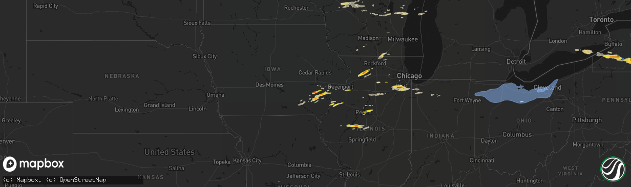
Hail
Wind
Tornado
126,210
Estimated number of impacted properties by a 1.00" hail or larger25,166
Estimated number of impacted properties by a 1.75" hail or larger0
Estimated number of impacted properties by a 2.50" hail or largerStates Impacted by Hail Map on March 31, 2026
Storm reports
Oklahoma
| Date | Description |
|---|---|
| 03/31/20265:58 PM CDT | Dime to quarter size hail fell near the texas and oklahoma state line. |
Illinois
| Date | Description |
|---|---|
| 03/31/20266:55 PM CDT | Awos station k3lf litchfield municipal airport. |
| 03/31/20262:14 PM CDT | Report relayed by broadcast media. |
| 03/31/202610:31 AM CDT | A local report indicates 1.00 inch wind near Mount Morris |
| 03/31/202610:16 AM CDT | Largest hailstone was measured to be 1.5 inches in diameter. Most hail was approximately half an inch in diameter. Time estimated from radar. |
| 03/31/20269:44 AM CDT | A local report indicates 1.25 inch wind near Eureka |
| 03/31/20269:40 AM CDT | A local report indicates 1.00 inch wind near 1 N Eureka |
| 03/31/20269:37 AM CDT | Report from mping. |
| 03/31/20269:35 AM CDT | Report from mping. |
| 03/31/20269:34 AM CDT | Multiple public reports of quarter to golf ball size hail in new lenox. Time estimated from radar. |
| 03/31/20269:34 AM CDT | Photo shared of approximately ping pong ball size hail at route 53 and laraway road. Time estimated from radar. |
| 03/31/20269:33 AM CDT | East cruger & deemack road. Delayed report. Time estimated from radar. |
| 03/31/20269:29 AM CDT | Report from mping. |
| 03/31/20269:28 AM CDT | Report from mping. |
| 03/31/20269:27 AM CDT | A local report indicates 1.75 inch wind near 2 SSE Ingalls Park |
| 03/31/20269:27 AM CDT | A local report indicates 1.75 inch wind near 1 NW Easton |
| 03/31/20269:24 AM CDT | Photo shared of hail in preston heights. The largest hailstones were approximately quarter size. Time estimated from radar. |
| 03/31/20269:21 AM CDT | Report from mping. |
| 03/31/20269:21 AM CDT | Photo shared on social media showing several large hailstones at moen avenue and midland avenue in rockdale. The largest hailstones were approximately golf ball size. T |
| 03/31/20269:18 AM CDT | Multiple trained spotter reports of dime to quarter size hail at and near joliet junior college. |
| 03/31/20269:17 AM CDT | A local report indicates 1.50 inch wind near 4 WNW Washington |
| 03/31/20269:12 AM CDT | Nickel to quarter size. |
| 03/31/20268:29 AM CDT | Time estimated from radar. |
| 03/31/20267:40 AM CDT | Passed along by broadcast media. |
| 03/31/20267:30 AM CDT | A local report indicates 1.00 inch wind near 3 E Rozetta |
Ohio
| Date | Description |
|---|---|
| 03/31/20266:54 PM CDT | Healthy pine tree snapped. |
| 03/31/20266:50 PM CDT | Power lines downed. |
| 03/31/20266:38 PM CDT | Tree down at sr 18 and township rd 15. Time estimated via radar. |
| 03/31/20266:28 PM CDT | Dispatch reports roof blown off in independence. Time estimated via radar. |
| 03/31/20266:27 PM CDT | Very large tree fell onto car in defiance. Unknown if any injuries. Time estimated via radar. |
| 03/31/20266:26 PM CDT | Several reports of powerlines down in and around scott. Time estimated via radar. |
| 03/31/20266:26 PM CDT | Power poles down on dutch-john road east of scott. Reported by van wert county emergency manager. |
| 03/31/20266:25 PM CDT | Large tree uprooted onto home at the intersection of cromley rd and sr 111. Time estimated via radar. |
| 03/31/20266:24 PM CDT | Trees down at sr 127 and sr 18. Time estimated via radar. |
| 03/31/20266:23 PM CDT | Dispatch reports roof blown off. |
| 03/31/20266:22 PM CDT | Multiple power poles and lines down in sherwood. Time estimated via radar. |
| 03/31/20266:22 PM CDT | A grain bin was destroyed on fountain street west of us 127 in sherwood. Time estimated via radar. |
| 03/31/20266:20 PM CDT | Tree down on sr 127. Time estimated via radar. |
| 03/31/20266:12 PM CDT | Barn damaged near jericho and roselawn roads. Time estimated via radar. |
| 03/31/20266:10 PM CDT | Photo relayed by broadcast media of metal roofing thrown into a nearby field in hicksville. Time estimated via radar. |
| 03/31/20266:10 PM CDT | Mesonet station dvi11214 hicksville. |
| 03/31/20266:10 PM CDT | Corrects previous report from 3 se hicksville. Mesonet station dvi11214 hicksville. |
| 03/31/20266:09 PM CDT | A brief tornado |
| 03/31/20266:03 PM CDT | Dispatch reports roof blown off and barn blown down. |
| 03/31/20265:46 PM CDT | Part of roof torn off of southeast high school. |
| 03/31/20265:18 PM CDT | Asos station khzy ashtabula. |
| 03/31/20264:55 PM CDT | 65 mph gust and dime size hail. |
| 03/31/20264:52 PM CDT | Trees and powerlines down on hopkins road. |
| 03/31/20264:50 PM CDT | Wires down on road. |
| 03/31/20264:45 PM CDT | Awos station kcgf. |
| 03/31/20264:44 PM CDT | Large tree down on beachwood drive. |
| 03/31/20264:42 PM CDT | Buoy station faio1 fairport... Oh. |
| 03/31/20264:40 PM CDT | Large tree down on powerlines leading to a road closure. Time estimated via radar. |
| 03/31/20264:32 PM CDT | Asos station kbkl cleveland. |
| 03/31/20264:31 PM CDT | Windows of a high rise office building at east 9th st and st. Clair ave blown out due to thunderstorm wind gusts. |
| 03/31/20264:30 PM CDT | Large portion of roof came off an apartment building on fulton road. |
| 03/31/20264:28 PM CDT | Tree uprooted. |
| 03/31/20264:26 PM CDT | Social media report of a large tree downed in cleveland. Time estimated via radar. |
| 03/31/20264:24 PM CDT | Asos station kcle cleveland. |
| 03/31/20264:18 PM CDT | 3 very large trees down near the intersection of canterbury and detroit roads. |
| 03/31/20264:14 PM CDT | Trained weather spotter reports 74 mph gust on personal weather station. |
| 03/31/20264:09 PM CDT | Asos station klpr lorain elyria. |
| 03/31/20264:04 PM CDT | Tree down across north main street. |
| 03/31/20264:04 PM CDT | Very large tree down on a house on north main street. Time estimated via radar. |
| 03/31/20263:53 PM CDT | Power lines and poles down in collins. Time estimated via radar. |
| 03/31/20263:47 PM CDT | Social media report of trees down... Power poles down... And outdoor playset tossed on state route 4... South of attica. Time estimated via radar. |
| 03/31/20263:17 PM CDT | Multiple power poles down near buchanan rd and oak dr. Time estimated via radar. |
| 03/31/20263:04 PM CDT | 66 mph wind gust measured on personal weather station. |
| 03/31/20262:47 PM CDT | K1g0 reports 51 knot wind gust. |
| 03/31/20262:39 PM CDT | Tree and powerlines down on roachton rd. Time estimated via radar. |
| 03/31/20262:38 PM CDT | Semi truck flipped over on us-24 near hertzfeld rd. Time estimated via radar. |
| 03/30/20268:56 PM CDT | A brief ef0 tornado touched down just west of honeytown road near apple creek and moved east across three residential properties before lifting east of honeytown road. |
| 03/30/20268:56 PM CDT | Tree through a house on honeytown road. Residents trapped in the basement. Time estimated via radar. |
| 03/30/20268:45 PM CDT | Social media report for a large tree down in big prairie. |
| 03/30/20268:26 PM CDT | Tree downed in bellville. |
| 03/30/20268:25 PM CDT | Tree and power-lines down in lucas. |
| 03/30/20268:20 PM CDT | Multiple trees and power-lines downed along route 430 east of mansfield. |
| 03/30/20268:00 PM CDT | Social media report of a large tree down in stevens park. Time estimated via radar. |
| 03/30/20267:53 PM CDT | Tree downed on leesville road. |
| 03/30/20267:49 PM CDT | Ema relayed a report of up to 27 transmission lines down on sr 4 south of carrothers in northern crawford county. Time estimated via radar. |
| 03/30/20267:34 PM CDT | Report from mping: quarter |
| 03/30/20267:34 PM CDT | Social media photo of hail as big as one inch in brunswick. Time estimated via radar. |
Wisconsin
| Date | Description |
|---|---|
| 03/31/202610:42 AM CDT | Report from mping: half dollar |
| 03/31/202610:27 AM CDT | Picture of quarter sized hail in the town of mosel. |
| 03/31/20268:43 AM CDT | Report from mping: quarter |
Mississippi
| Date | Description |
|---|---|
| 03/31/20266:53 PM CDT | Reported large tree on home in the water valley area. Exact time and location estimated on radar. |
Texas
| Date | Description |
|---|---|
| 03/31/20266:46 PM CDT | A local report indicates 1.75 inch wind near 5 SW Childress |
| 03/31/20266:38 PM CDT | A local report indicates 1.00 inch wind near 1 WNW Childress |
| 03/31/20266:22 PM CDT | A few quarter sized stones observed... But mostly penny size or less. |
| 03/31/20266:06 PM CDT | A local report indicates 1.00 inch wind near 7 NW Childress |
| 03/31/20264:56 PM CDT | Hail up to quarter size fell in samnorwood. Report via social media. |
| 03/30/202610:34 PM CDT | A local report indicates 58 MPH wind near 8 SE Guthrie |
| 03/30/20269:24 PM CDT | A local report indicates 59 MPH wind near 2 WNW Guthrie |
| 03/30/20268:55 PM CDT | Hailstones ranging from quarter to golf ball size. |
| 03/30/20268:10 PM CDT | Additional severe gusts of 59 to 62 mph measured from 809 pm to 812 pm. |
| 03/30/20267:43 PM CDT | A local report indicates 1.25 inch wind near 1 NE Paducah |
| 03/30/20267:35 PM CDT | A local report indicates 1.50 inch wind near 4 NE Paducah |
Iowa
| Date | Description |
|---|---|
| 03/31/202610:39 AM CDT | A local report indicates 1.00 inch wind near 1 SW Sand Springs |
| 03/31/202610:23 AM CDT | Via social media. |
| 03/31/20269:29 AM CDT | A local report indicates 1.75 inch wind near 3 N Washington |
| 03/31/20268:14 AM CDT | Via social media... Delayed report. |
| 03/31/20267:18 AM CDT | Via social media. |
| 03/31/20267:16 AM CDT | A local report indicates 1.00 inch wind near Wayland |
| 03/31/20267:15 AM CDT | Estimate of quarter-sized to ping pong ball-sized hail. |
Missouri
| Date | Description |
|---|---|
| 03/30/202610:32 PM CDT | Report from mping: quarter |
Massachusetts
| Date | Description |
|---|---|
| 03/30/20268:52 PM CDT | Report of a tree down in lenox. Time estimated from radar. |
| 03/30/20268:10 PM CDT | Tree downed on east buckland rd in buckland. Relayed by amateur radio. |
| 03/30/20268:00 PM CDT | Corrects previous tstm wnd dmg report from 2 sse buckland for time. Tree downed on east buckland rd in buckland. Relayed by amateur radio. |
| 03/30/20267:50 PM CDT | Tree down blocking route 2 around mile marker 26 near charlemont. Relayed by amateur radio. |
| 03/30/20267:25 PM CDT | Report of a tree down in richmond. Time estimated from radar. |
New York
| Date | Description |
|---|---|
| 03/31/20266:35 PM CDT | Tree and wires down on road. |
| 03/31/20266:30 PM CDT | A local report indicates 1.75 inch wind near Walton |
| 03/31/20266:30 PM CDT | Asos station kdkk dunkirk airport. |
| 03/31/20266:25 PM CDT | Nys mesonet station fred fredonia. |
| 03/31/20266:10 PM CDT | Power poles snapped. |
| 03/31/20266:04 PM CDT | A local report indicates 1.50 inch wind near Bainbridge |
| 03/31/20266:01 PM CDT | A local report indicates 1.25 inch wind near Afton |
| 03/31/20266:00 PM CDT | A local report indicates 1.00 inch wind near 2 NNW Chenango Bridge |
| 03/31/20266:00 PM CDT | A local report indicates 1.00 inch wind near Chenango Forks |
| 03/31/20265:58 PM CDT | A local report indicates 1.00 inch wind near 2 NNE Chenango Bridge |
| 03/31/20265:45 PM CDT | Multiple trees and wires down in the vicinity of broome county landfill. |
| 03/31/20265:36 PM CDT | Large hail resulted in broken windows and siding damage on house. |
| 03/31/20265:36 PM CDT | A local report indicates 1.75 inch wind near Greene |
| 03/31/20263:50 PM CDT | A local report indicates 1.00 inch wind near Wayne |
| 03/31/20263:45 PM CDT | A local report indicates 1.00 inch wind near Canisteo |
| 03/31/20263:28 PM CDT | A local report indicates 1.00 inch wind near Prattsburg |
| 03/31/20263:26 PM CDT | A local report indicates 1.00 inch wind near 2 NNW Avoca |
| 03/31/20262:40 PM CDT | Multiple trees and powerlines down near ashford hollow road. |
| 03/31/20262:40 PM CDT | A local report indicates 1.00 inch wind near 2 WSW West Valley |
| 03/31/20262:34 PM CDT | Received report on facebook of accumulating hail on route 219 just south of cattaraugus creek. Time estimated based on radar. |
| 03/31/20262:17 PM CDT | Received report with photo. |
| 03/31/20262:17 PM CDT | Received report with photo via facebook. |
| 03/31/20262:14 PM CDT | Report from facebook of tree falling on a house. Time estimated based on radar. |
| 03/31/20262:09 PM CDT | Updating previous report from perrysburg. Half dollar size hail. Cars dented. Holes in siding due to wind driven hail. Large accumulations of hail making roads slushy. |
| 03/31/20262:09 PM CDT | Wind driven hail. Large accumulations of hail making roads slushy. |
| 03/30/20267:58 PM CDT | Tree downed across new york route 9j. The road was closed between stuyvesant falls road and day road. |
| 03/30/20267:28 PM CDT | Multiple trees down on gooding rd near crump hill rd and rte 42 in the town of shandaken. Time estimated from radar. |
| 03/30/20267:12 PM CDT | Tree down on road. |
| 03/30/20267:02 PM CDT | Report of a single tree down on route 9j in stuyvesant. Time estimated from radar. |
Kansas
| Date | Description |
|---|---|
| 03/30/202611:16 PM CDT | A local report indicates 1.00 inch wind near Erie |
| 03/30/202610:45 PM CDT | A local report indicates 60 MPH wind near Chanute |
| 03/30/202610:34 PM CDT | Public reported hail with pictures sent to em. |
| 03/30/20269:55 PM CDT | A local report indicates 1.25 inch wind near 4 NE Fredonia |
Indiana
| Date | Description |
|---|---|
| 03/31/20266:31 PM CDT | Several large tree branches snapped in north manchester. Time estimated via radar. |
| 03/31/20266:30 PM CDT | Phot on facebook of damage to a barn on packerton rd near north manchester. Time estimated via radar. |
| 03/31/20266:24 PM CDT | Roof damage to a home in akron. Time estimated via radar. |
| 03/31/20265:59 PM CDT | Report from mping: quarter |
| 03/31/20265:55 PM CDT | A local report indicates 61 MPH wind near 4 NE Fort Wayne |
| 03/31/20265:53 PM CDT | A local report indicates 60 MPH wind near 3 SW Wallen |
| 03/31/20265:50 PM CDT | Report from mping: quarter |
| 03/31/20265:31 PM CDT | Corrects time of previous tstm wnd dmg report from north manchester. Several large tree branches snapped in north manchester. Time estimated via radar. |
| 03/31/20265:30 PM CDT | Corrects time of previous tstm wnd dmg report from 3 nnw north manchester. Photo on facebook of damage to a barn on packerton rd near north manchester. Time estimated v |
| 03/31/20265:28 PM CDT | Roof damage to home between akron and silver lake. Time estimated via radar. |
| 03/31/20265:26 PM CDT | Tree downed 950 s between 500 and 600 w. Time estimated from radar. |
| 03/31/20265:26 PM CDT | 1 inch hail on the south side of burket. Time estimated via radar. |
| 03/31/20265:26 PM CDT | Corrects time of previous tstm wnd dmg report from mentone. Several trees down in mentone. Time estimated via radar. |
| 03/31/20265:25 PM CDT | Photo on x shows hail up to quarter size in claypool. Time estimated via radar. |
| 03/31/20265:24 PM CDT | Corrects time of previous tstm wnd dmg report from 1 nnw akron. Roof damage to a home in akron. Time estimated via radar. |
| 03/31/20265:24 PM CDT | Photo showing hail just larger than a quarter south of warsaw. Time estimated via radar. |
| 03/31/20265:24 PM CDT | A local report indicates 1.00 inch wind near 3 SW Winona Lake |
| 03/31/20265:21 PM CDT | Quarter size hail at palestine lake. Time estimated via radar. |
| 03/31/20265:20 PM CDT | Corrects previous hail report from claypool. Time estimated from radar. |
| 03/31/20265:20 PM CDT | Picture on facebook of large tree branches down near beaver dam lake. Public report also says a barn was damaged. Time estimated via radar. |
| 03/31/20265:20 PM CDT | Photo on facebook showing a roof torn off of a large animal barn north of akron near beaver dam. Time estimated via radar. |
| 03/31/20265:20 PM CDT | Photo on facebook of several large trees down and numerous other smaller limbs. Time estimated via radar. |
| 03/31/20265:18 PM CDT | A local report indicates 1.00 inch wind near Mentone |
| 03/31/20265:18 PM CDT | Emergency manager relayed picture of a tree down that took out a portion of a home on north broadway street. Unknown if any injuries. Time estimated via radar. |
| 03/31/20265:18 PM CDT | Large tree snapped in mentone. Time estimated via radar. |
| 03/31/20265:17 PM CDT | A local report indicates 1.00 inch wind near Burket |
| 03/31/20265:10 PM CDT | Tree blown down and caused roof damage to a house. |
| 03/31/20265:05 PM CDT | Photo on facebook of a tree uprooted onto a house n sr 110 on the marshall and fulton county line. No injuries. Time estimated via radar. |
| 03/31/20265:03 PM CDT | Dime size hail also reported. |
| 03/31/20264:51 PM CDT | Tree downed near washington street and plymouth street. Time estimated from radar. |
| 03/31/20264:50 PM CDT | Time estimated from radar. |
| 03/30/20267:26 PM CDT | Several trees down in mentone. Time estimated via radar. |
Pennsylvania
| Date | Description |
|---|---|
| 03/31/20266:56 PM CDT | Trees down across cherry grove road. |
| 03/31/20266:55 PM CDT | Trees and wires down across six mile road. |
| 03/31/20266:45 PM CDT | Wires were reported down. |
| 03/31/20266:34 PM CDT | Trees down across route 127 and campbell hill road. |
| 03/31/20266:28 PM CDT | Six trees reported down. |
| 03/31/20266:26 PM CDT | Tree down. |
| 03/31/20265:57 PM CDT | Tree down. |
| 03/31/20265:55 PM CDT | Social media report and photos of several trees down in waterford. The corner of a roof was damaged on a home. |
| 03/31/20265:46 PM CDT | Tree down on house. |
| 03/31/20265:35 PM CDT | Large pine tree down on house. |
| 03/31/20265:32 PM CDT | Social media report of trees down in lake city. Time estimated via radar. |
| 03/31/20266:33 AM CDT | Report of some trees snapped in half. Time estimated based on radar. |
| 03/30/202611:10 PM CDT | Report of trees down near the intersection of barnes lake road and clay pike. Time estimated based on radar. |
| 03/30/202611:09 PM CDT | Report of shed blown over in background plus down and snapped trees in the area. Time estimated based on radar. |
| 03/30/202611:05 PM CDT | Tree down on power lines. |
| 03/30/202611:04 PM CDT | Report of damage to multiple trees in the haler heights area of mckeesport near renziehausen park. Time estimated based on radar. |
| 03/30/202610:50 PM CDT | Mesonet station 11510 1 se robinson township. |
| 03/30/202610:12 PM CDT | Pa-38 is closed in washington township... Butler county due to a downed tree on the roadway with wires involved. |
| 03/30/20269:21 PM CDT | Trees and wires down across washington avenue. |
| 03/30/20268:15 PM CDT | Tree down on wires. |
| 03/30/20268:04 PM CDT | Tree down along 1 lane of north liberty road. Time estimated based on radar. |
| 03/30/20267:42 PM CDT | Tree down blocking cochranton road near french creek. Time estimated based on radar. |
| 03/30/20267:40 PM CDT | Several trees down. |
| 03/30/20267:37 PM CDT | Several trees down. |
| 03/30/20267:37 PM CDT | Large trees on wires. |
| 03/30/20267:24 PM CDT | Trees and wires down across route 59. |
| 03/30/20267:06 PM CDT | Downed trees blocking minard run road. |
Cities Impacted by Hail Map on March 31, 2026
- Tomah, WI
- Warrens, WI
- Oakville, IA
- Brighton, IA
- Wayland, IA
- Mount Pleasant, IA
- Oquawka, IL
- Seaton, IL
- Biggsville, IL
- Gladstone, IL
- Monmouth, IL
- Camp Douglas, WI
- Batavia, IA
- Burlington, IA
- Necedah, WI
- Nekoosa, WI
- Galesburg, IL
- Alexis, IL
- Gerlaw, IL
- Columbus Junction, IA
- Compton, IL
- Paw Paw, IL
- Arkdale, WI
- Little York, IL
- Friendship, WI
- Ottumwa, IA
- Bloomfield, IA
- Letts, IA
- Earlville, IL
- Crawfordsville, IA
- Coloma, WI
- Bancroft, WI
- Westfield, WI
- Hancock, WI
- Wapello, IA
- Muscatine, IA
- Eldon, IA
- Agency, IA
- Leland, IL
- Hedrick, IA
- Wautoma, WI
- Montello, WI
- Hennepin, IL
- Princeton, IL
- Wild Rose, WI
- Bradford, IL
- Princeton, WI
- Astoria, IL
- Oglesby, IL
- Peru, IL
- Standard, IL
- Mark, IL
- Cedar Point, IL
- Granville, IL
- Tonica, IL
- Green Lake, WI
- Markesan, WI
- Washington, IA
- Fairfield, IA
- Ottawa, IL
- Marseilles, IL
- Ripon, WI
- Minooka, IL
- Havana, IL
- Bath, IL
- Oshkosh, WI
- Grand Ridge, IL
- Brandon, WI
- Sandwich, IL
- Plano, IL
- Shorewood, IL
- Joliet, IL
- Kilbourne, IL
- Easton, IL
- Washington, IL
- East Peoria, IL
- Metamora, IL
- Eldorado, WI
- Rosendale, WI
- Peoria, IL
- Chillicothe, IL
- Eureka, IL
- Pickett, WI
- Malone, WI
- Fond Du Lac, WI
- New Lenox, IL
- Mokena, IL
- Frankfort, IL
- West Chester, IA
- Lone Tree, IA
- Ainsworth, IA
- Conesville, IA
- Riverside, IA
- Roanoke, IL
- Channahon, IL
- Wallace, MI
- Mason City, IL
- Mount Calvary, WI
- Saint Cloud, WI
- Redgranite, WI
- Winfield, IA
- Manhattan, IL
- Sterling, IL
- Homer Glen, IL
- Lockport, IL
- Elwood, IL
- Matteson, IL
- New Holland, IL
- Chilton, WI
- San Jose, IL
- Elkhart Lake, WI
- Monee, IL
- University Park, IL
- Pekin, IL
- Ipava, IL
- Columbus City, IA
- Steger, IL
- Richton Park, IL
- Park Forest, IL
- Crete, IL
- Cleveland, WI
- Plymouth, WI
- Sheboygan Falls, WI
- Sheboygan, WI
- Lincoln, IL
- Elburn, IL
- Maple Park, IL
- Milledgeville, IL
- Romeoville, IL
- Plainfield, IL
- Emden, IL
- Cole Camp, MO
- Polo, IL
- Orland Park, IL
- Oregon, IL
- Atlanta, IL
- Woodridge, IL
- Franklin Grove, IL
- Ashton, IL
- Mount Morris, IL
- Lake Geneva, WI
- Fontana, WI
- Peotone, IL
- Stillman Valley, IL
- Capron, IL
- New Boston, IL
- Morning Sun, IA
- Wilton, IA
- Olds, IA
- Fruitland, IA
- Grandview, IA
- Nichols, IA
- Illinois City, IL
- Lockridge, IA
- Harvard, IL
- Dixon, IL
- Moscow, IA
- Byron, IL
- Poplar Grove, IL
- Caledonia, IL
- Clinton, WI
- Roscoe, IL
- Sharon, WI
- South Beloit, IL
- Delavan, WI
- Darien, WI
- Iowa City, IA
- Hills, IA
- West Liberty, IA
- Walworth, WI
- Argyle, WI
- Atalissa, IA
- New Glarus, WI
- Belleville, WI
- Oconomowoc, WI
- Ixonia, WI
- Watertown, WI
- Silver Creek, NY
- Dunkirk, NY
- Antwerp, OH
- Hicksville, OH
- Cecil, OH
- Mark Center, OH
- Sherwood, OH
- Ney, OH
- Defiance, OH
- Irving, NY
- Forestville, NY
- South Dayton, NY
- Perrysburg, NY
- Gowanda, NY
- Collins, NY
- Lawtons, NY
- Valders, WI
- Kiel, WI
- Manitowoc, WI
- Reedsville, WI
- Sheridan, NY
- North Collins, NY
- Angola, NY
- Saint Nazianz, WI
- Holgate, OH
- New Bavaria, OH
- Napoleon, OH
- Oakwood, OH
- Cattaraugus, NY
- East Otto, NY
- Springville, NY
- Geneseo, IL
- Osco, IL
- Continental, OH
- Hamler, OH
- Leipsic, OH
- Malinta, OH
- Liberty Center, OH
- Grelton, OH
- Grand Rapids, OH
- McClure, OH
- West Valley, NY
- Waterville, OH
- Deshler, OH
- Bowling Green, OH
- Whitehouse, OH
- Delevan, NY
- Machias, NY
- Ottawa, OH
- Weston, OH
- Miller City, OH
- Custar, OH
- Perrysburg, OH
- Tontogany, OH
- Haskins, OH
- Rudolph, OH
- Dunbridge, OH
- Milton Center, OH
- Andalusia, IL
- Taylor Ridge, IL
- Orion, IL
- Colona, IL
- Coal Valley, IL
- Crest Hill, IL
- McComb, OH
- North Baltimore, OH
- Pandora, OH
- Hoytville, OH
- Mount Cory, OH
- Cygnet, OH
- Portage, OH
- Findlay, OH
- Northwood, OH
- Walbridge, OH
- Millbury, OH
- Rossford, OH
- Maumee, OH
- Toledo, OH
- Franklinville, NY
- Rushford, NY
- Cuba, NY
- Farmersville Station, NY
- Houghton, NY
- Fillmore, NY
- Ellicottville, NY
- Swain, NY
- Dalton, NY
- Jerry City, OH
- Van Buren, OH
- Luckey, OH
- Pemberville, OH
- Arcadia, OH
- Fostoria, OH
- Bloomdale, OH
- Stony Ridge, OH
- Bradner, OH
- Risingsun, OH
- West Millgrove, OH
- Wayne, OH
- Gibsonburg, OH
- Helena, OH
- Genoa, OH
- Woodville, OH
- Williston, OH
- Curtice, OH
- Martin, OH
- Kansas, OH
- Clay Center, OH
- Dansville, NY
- Arkport, NY
- Wayland, NY
- Caneadea, NY
- Belfast, NY
- Cohocton, NY
- Burgoon, OH
- Tiffin, OH
- Fremont, OH
- Bettsville, OH
- Graytown, OH
- Elmore, OH
- Lindsey, OH
- Rocky Ridge, OH
- Oak Harbor, OH
- Angelica, NY
- Belmont, NY
- Canaseraga, NY
- Eden, NY
- Hunt, NY
- Tinley Park, IL
- Avoca, NY
- Bascom, OH
- Alvada, OH
- Almond, NY
- Prattsburgh, NY
- Bath, NY
- Country Club Hills, IL
- Friendship, NY
- Black Creek, NY
- Alfred Station, NY
- Ozark, AL
- Clopton, AL
- Skipperville, AL
- Alfred, NY
- Hornell, NY
- Hammondsport, NY
- Pulteney, NY
- Green Springs, OH
- New Riegel, OH
- Bloomville, OH
- Republic, OH
- Old Fort, OH
- Lacarne, OH
- Clyde, OH
- Milan, OH
- Castalia, OH
- Sandusky, OH
- Lakeside Marblehead, OH
- Attica, OH
- Vickery, OH
- Port Clinton, OH
- Monroeville, OH
- Bellevue, OH
- Huron, OH
- Canisteo, NY
- Newville, AL
- Andover, NY
- Scio, NY
- Saint John, IN
- Cedar Lake, IN
- Crown Point, IN
- Coffee Springs, AL
- Chancellor, AL
- Morris, IL
- Bradford, NY
- Dundee, NY
- Keuka Park, NY
- Penn Yan, NY
- Cameron, NY
- Rock Stream, NY
- Watkins Glen, NY
- New Washington, OH
- Willard, OH
- Norwalk, OH
- Plymouth, OH
- North Fairfield, OH
- Amherst, OH
- Wakeman, OH
- Lorain, OH
- Vermilion, OH
- Collins, OH
- Berlin Heights, OH
- Lowpoint, IL
- Washburn, IL
- Beecher, IL
- Merrillville, IN
- Burdett, NY
- Oberlin, OH
- Kipton, OH
- New London, OH
- Wellington, OH
- Greenwich, OH
- Elyria, OH
- Avon Lake, OH
- Sheffield Lake, OH
- Avon, OH
- North Ridgeville, OH
- Bay Village, OH
- Minonk, IL
- Valparaiso, IN
- Grafton, OH
- Lagrange, OH
- Rocky River, OH
- Olmsted Falls, OH
- North Olmsted, OH
- Columbia Station, OH
- Westlake, OH
- Lakewood, OH
- Cleveland, OH
- Brookpark, OH
- Berea, OH
- Valley City, OH
- Litchfield, OH
- Strongsville, OH
- Brunswick, OH
- Independence, OH
- Medina, OH
- North Royalton, OH
- Trumansburg, NY
- Odessa, NY
- Alpine, NY
- Abbeville, AL
- McGraw, NY
- Marathon, NY
- Cortland, NY
- Hebron, IN
- Lowell, IN
- Mclean, TX
- Cincinnatus, NY
- Broadview Heights, OH
- Hinckley, OH
- Euclid, OH
- Eastlake, OH
- Wickliffe, OH
- Kouts, IN
- Knox, IN
- Wellington, TX
- Quail, TX
- Culver, IN
- Ithaca, NY
- Plymouth, IN
- Shamrock, TX
- Hudson, OH
- Richfield, OH
- Akron, OH
- Maple Heights, OH
- Beachwood, OH
- Brecksville, OH
- Bedford, OH
- Macedonia, OH
- Northfield, OH
- Peninsula, OH
- Grand River, OH
- Solon, OH
- Mentor, OH
- Painesville, OH
- Chagrin Falls, OH
- Willoughby, OH
- Gates Mills, OH
- Twinsburg, OH
- Chesterland, OH
- Argos, IN
- Rochester, IN
- Tippecanoe, IN
- Aurora, OH
- Chardon, OH
- Novelty, OH
- Streetsboro, OH
- Cuyahoga Falls, OH
- Geneva, OH
- Madison, OH
- Thompson, OH
- Austinburg, OH
- Huntsburg, OH
- Montville, OH
- Ashtabula, OH
- Rock Creek, OH
- Mantua, OH
- Newbury, OH
- Perry, OH
- Burton, OH
- Richford, NY
- Berkshire, NY
- Mentone, IN
- Bourbon, IN
- Etna Green, IN
- Claypool, IN
- Wanatah, IN
- Ravenna, OH
- Middlefield, OH
- Windsor, OH
- West Farmington, OH
- Hiram, OH
- Rome, OH
- Garrettsville, OH
- Windham, OH
- Orwell, OH
- Jefferson, OH
- Southington, OH
- North Bloomfield, OH
- Bristolville, OH
- Conneaut, OH
- Dorset, OH
- Kingsville, OH
- North Kingsville, OH
- Burket, IN
- Silver Lake, IN
- Akron, IN
- Warsaw, IN
- Willseyville, NY
- Candor, NY
- Brooktondale, NY
- Newark Valley, NY
- Williamsfield, OH
- Cortland, OH
- Pierpont, OH
- Andover, OH
- Farmdale, OH
- Kinsman, OH
- North Springfield, PA
- West Springfield, PA
- Albion, PA
- Conneautville, PA
- Linesville, PA
- Lake City, PA
- Cranesville, PA
- Fairview, PA
- East Springfield, PA
- Girard, PA
- Springboro, PA
- Memphis, TX
- Childress, TX
- Spencer, NY
- Whitney Point, NY
- Maine, NY
- Lisle, NY
- Newfield, NY
- Greenwood, MS
- Kimmell, IN
- Albion, IN
- Pierceton, IN
- Winona Lake, IN
- Atwood, IN
- South Whitley, IN
- Larwill, IN
- Columbia City, IN
- Churubusco, IN
- Port Crane, NY
- Greene, NY
- Chenango Forks, NY
- Harpursville, NY
- Laotto, IN
- Avilla, IN
- McDonough, NY
- Castle Creek, NY
- Glen Aubrey, NY
- Binghamton, NY
- Owego, NY
- Barton, NY
- Johnson City, NY
- Atlantic, PA
- Hartstown, PA
- Conneaut Lake, PA
- Edinboro, PA
- Meadville, PA
- Harmonsburg, PA
- Adamsville, PA
- Jamestown, PA
- Greenville, PA
- Erie, PA
- Venango, PA
- Cochranton, PA
- Harborcreek, PA
- Cambridge Springs, PA
- North East, PA
- Saegertown, PA
- Waterford, PA
- McKean, PA
- Fort Wayne, IN
- Huntertown, IN
- Auburn, IN
- Garrett, IN
- Leo, IN
- Spencerville, IN
- Grabill, IN
- Harlan, IN
- Bainbridge, NY
- Afton, NY
- Endicott, NY
- Oxford, NY
- Carrollton, MS
- Sidney, NY
- Masonville, NY
- Unadilla, NY
- Hollis, OK
- Woodburn, IN
- Monroeville, IN
- New Haven, IN
- Hoagland, IN
- Payne, OH
- Paulding, OH
- Convoy, OH
- Tell, TX
- Vestal, NY
- Windsor, NY
- Kirkwood, NY
- Ouaquaga, NY
- Grenada, MS
- Sidney Center, NY
- Walton, NY
- Grover Hill, OH
- Latty, OH
- Scott, OH
- Haviland, OH
- Van Wert, OH
- Melrose, OH
- Cloverdale, OH
- Franklin, NY
- Erick, OK
- Coffeeville, MS
- Nineveh, NY
- Conklin, NY
- Fort Jennings, OH
- Middle Point, OH
- Ottoville, OH
- Delphos, OH
- Kalida, OH
- Hamden, NY
- Delhi, NY
- Delancey, NY
- Deposit, NY
- North Manchester, IN
- Guilford, NY
- Winamac, IN
- Medaryville, IN
- Vinson, OK
- Gould, OK
- South Plymouth, NY
- Norwich, NY
- North Judson, IN
- Paducah, TX
- Columbus Grove, OH
- Vaughnsville, OH
- Huntington, IN
- East Branch, NY
- Derby, NY
- Hancock, NY
- Ashkum, IL
- Francesville, IN
- Liberty Mills, IN
- Mount Olive, IL
- Litchfield, IL
- Butler, IL
- Hillsboro, IL
- Wattsburg, PA
- Guys Mills, PA
- Corry, PA
- Centerville, PA
- Townville, PA
- Spartansburg, PA
- Union City, PA
- Spring Creek, PA
- Bear Lake, PA
- Columbus, PA
- Sugar Grove, PA
- Clymer, NY
- Pittsfield, PA
- Westfield, NY
- Mayville, NY
- Stockton, NY
- Stow, NY
- Ripley, NY
- Cassadaga, NY
- Fredonia, NY
- Lakewood, NY
- Bemus Point, NY
- Van Buren Point, NY
- Sherman, NY
- Sinclairville, NY
- Brocton, NY
- Chautauqua, NY
- Ashville, NY
- Portland, NY
- Panama, NY
- Dewittville, NY
- Jamestown, NY
- Findley Lake, NY
- Susquehanna, PA
- Downsville, NY
- Roanoke, IN
- Cherry Creek, NY
- Lily Dale, NY
- Celoron, NY
- Gerry, NY
- Titusville, PA
- Hydetown, PA
- Grand Valley, PA
- Cooperstown, PA
- Youngsville, PA
- Garland, PA
- Andes, NY
- Roscoe, NY
- Margaretville, NY
- Livingston Manor, NY
- Arkville, NY
- Fleischmanns, NY
- Cromwell, IN
- Yoder, IN
- North Webster, IN
- Warren, OH
- Leavittsburg, OH
- Fowler, OH
- Burghill, OH
- Bluffton, OH
- Rawson, OH
- Benton Ridge, OH
- Jenera, OH
- Forest, OH
- Carey, OH
- Arlington, OH
- Mount Blanchard, OH
- Vanlue, OH
- Kewanna, IN
- Mangum, OK
- Leesburg, IN
- Kirby, OH
- Sycamore, OH
- Wharton, OH
- Upper Sandusky, OH
- McCutchenville, OH
- Fishs Eddy, NY
- Long Eddy, NY
- Neversink, NY
- Woodbourne, NY
- Liberty, NY
- Grahamsville, NY
- Parksville, NY
- Claryville, NY
- Toronto, KS
- Fredonia, KS
- Napanoch, NY
- Kerhonkson, NY
- West Shokan, NY
- Olivebridge, NY
- Newton Falls, OH
- North Jackson, OH
- Youngstown, OH
- Mineral Ridge, OH
- Niles, OH
- McDonald, OH
- Girard, OH
- Blair, OK
- Granite, OK
- Wadsworth, OH
- Lone Wolf, OK
- Yates Center, KS
- Canfield, OH
- Crowell, TX
- Bucyrus, OH
- Nevada, OH
- Harpster, OH
- Morral, OH
- Crestline, OH
- Shelby, OH
- Tiro, OH
- Caledonia, OH
- Chatfield, OH
- Galion, OH
- Marion, OH
- Mansfield, OH
- Shiloh, OH
- Nova, OH
- Ashland, OH
- Lucas, OH
- Quanah, TX
- Demotte, IN
- Struthers, OH
- Campbell, OH
- Piedmont, KS
- Lake Milton, OH
- Diamond, OH
- Berlin Center, OH
- Howard, KS
- Chillicothe, TX
- Severy, KS
- Fall River, KS
- Atlanta, KS
- Leon, KS
- Latham, KS
- Niantic, IL
- Spur, TX
- Benedict, KS
- Dickens, TX
- Cambridge, KS
- Burden, KS
- Beaumont, KS
- Buffalo, KS
- Gridley, KS
- Le Roy, KS
- Burlington, KS
- Chanute, KS
- Seymour, TX
- Altoona, KS
- Old Glory, TX
- Aspermont, TX
- Westphalia, KS
- Holton, KS
- Munday, TX
- Pittsburgh, PA
- Monroeville, PA
- Coraopolis, PA
- Bulger, PA
- East Pittsburgh, PA
- Buena Vista, PA
- New Stanton, PA
- Imperial, PA
- Claridge, PA
- East McKeesport, PA
- Herminie, PA
- Bethel Park, PA
- Crescent, PA
- Sewickley, PA
- Harrison City, PA
- Wilmerding, PA
- Darragh, PA
- Greensburg, PA
- Mckeesport, PA
- Turtle Creek, PA
- Glassport, PA
- Murrysville, PA
- Dravosburg, PA
- Aliquippa, PA
- Elizabeth, PA
- Pitcairn, PA
- West Mifflin, PA
- Westmoreland City, PA
- Duquesne, PA
- Oakdale, PA
- South Park, PA
- Delmont, PA
- North Versailles, PA
- McKees Rocks, PA
- Greenock, PA
- Trafford, PA
- Carnegie, PA
- Clairton, PA
- Ardara, PA
- Georgetown, PA
- Manor, PA
- Clinton, PA
- Hookstown, PA
- Export, PA
- Penn, PA
- Larimer, PA
- Braddock, PA
- Adamsburg, PA
- Irwin, PA
- Rillton, PA
- Jeannette, PA
- Burgettstown, PA
- Homestead, PA
- Arona, PA
- Grapeville, PA
- Muscotah, KS
- Erie, KS
- Thayer, KS
- Goree, TX
- Walnut, KS
- New Alexandria, PA
- Forbes Road, PA
- Green Valley, IL
- Littleton, IL
- McLean, IL
- Wathena, KS
- Waynesville, IL
- Saint Joseph, MO
- Hartsburg, IL
- Atchison, KS
- Elwood, KS
- Powhattan, KS
- Netawaka, KS
- Wetmore, KS
- Saint Paul, KS
- Horton, KS
- Corunna, IN
- Petersburg, IL
- Odessa, MO
- Arcola, IN
- Perrysville, OH
- Loudonville, OH
- Tallmadge, OH
- Atwater, OH
- Kent, OH
- Mogadore, OH
- Rootstown, OH