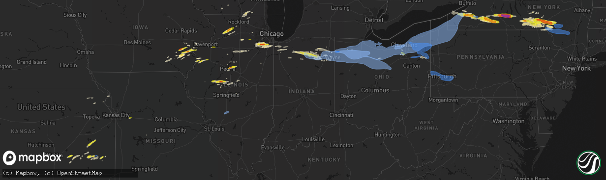
Hail Map in Indiana on March 31, 2026
The weather event in Indiana on March 31, 2026 includes Hail, Wind, and Tornado maps. 15 states and 881 cities were impacted and suffered possible damage. The total estimated number of properties impacted is 6,978.
Hail
Wind
Tornado
6,978
Estimated number of impacted properties by a 1.00" hail or larger0
Estimated number of impacted properties by a 1.75" hail or larger0
Estimated number of impacted properties by a 2.50" hail or largerStorm reports in Indiana
Indiana
| Date | Description |
|---|---|
| 03/31/20266:31 PM CDT | Several large tree branches snapped in north manchester. Time estimated via radar. |
| 03/31/20266:30 PM CDT | Phot on facebook of damage to a barn on packerton rd near north manchester. Time estimated via radar. |
| 03/31/20266:24 PM CDT | Roof damage to a home in akron. Time estimated via radar. |
| 03/31/20265:59 PM CDT | Report from mping: quarter |
| 03/31/20265:55 PM CDT | A local report indicates 61 MPH wind near 4 NE Fort Wayne |
| 03/31/20265:53 PM CDT | A local report indicates 60 MPH wind near 3 SW Wallen |
| 03/31/20265:50 PM CDT | Report from mping: quarter |
| 03/31/20265:31 PM CDT | Corrects time of previous tstm wnd dmg report from north manchester. Several large tree branches snapped in north manchester. Time estimated via radar. |
| 03/31/20265:30 PM CDT | Corrects time of previous tstm wnd dmg report from 3 nnw north manchester. Photo on facebook of damage to a barn on packerton rd near north manchester. Time estimated v |
| 03/31/20265:28 PM CDT | Roof damage to home between akron and silver lake. Time estimated via radar. |
| 03/31/20265:26 PM CDT | Corrects time of previous tstm wnd dmg report from mentone. Several trees down in mentone. Time estimated via radar. |
| 03/31/20265:26 PM CDT | 1 inch hail on the south side of burket. Time estimated via radar. |
| 03/31/20265:26 PM CDT | Tree downed 950 s between 500 and 600 w. Time estimated from radar. |
| 03/31/20265:25 PM CDT | Photo on x shows hail up to quarter size in claypool. Time estimated via radar. |
| 03/31/20265:24 PM CDT | Corrects time of previous tstm wnd dmg report from 1 nnw akron. Roof damage to a home in akron. Time estimated via radar. |
| 03/31/20265:24 PM CDT | Photo showing hail just larger than a quarter south of warsaw. Time estimated via radar. |
| 03/31/20265:24 PM CDT | A local report indicates 1.00 inch wind near 3 SW Winona Lake |
| 03/31/20265:21 PM CDT | Quarter size hail at palestine lake. Time estimated via radar. |
| 03/31/20265:20 PM CDT | Corrects previous hail report from claypool. Time estimated from radar. |
| 03/31/20265:20 PM CDT | Picture on facebook of large tree branches down near beaver dam lake. Public report also says a barn was damaged. Time estimated via radar. |
| 03/31/20265:20 PM CDT | Photo on facebook of several large trees down and numerous other smaller limbs. Time estimated via radar. |
| 03/31/20265:20 PM CDT | Photo on facebook showing a roof torn off of a large animal barn north of akron near beaver dam. Time estimated via radar. |
| 03/31/20265:18 PM CDT | Emergency manager relayed picture of a tree down that took out a portion of a home on north broadway street. Unknown if any injuries. Time estimated via radar. |
| 03/31/20265:18 PM CDT | A local report indicates 1.00 inch wind near Mentone |
| 03/31/20265:18 PM CDT | Large tree snapped in mentone. Time estimated via radar. |
| 03/31/20265:17 PM CDT | A local report indicates 1.00 inch wind near Burket |
| 03/31/20265:10 PM CDT | Tree blown down and caused roof damage to a house. |
| 03/31/20265:05 PM CDT | Photo on facebook of a tree uprooted onto a house n sr 110 on the marshall and fulton county line. No injuries. Time estimated via radar. |
| 03/31/20265:03 PM CDT | Dime size hail also reported. |
| 03/31/20264:51 PM CDT | Tree downed near washington street and plymouth street. Time estimated from radar. |
| 03/31/20264:50 PM CDT | Time estimated from radar. |
| 03/30/20267:26 PM CDT | Several trees down in mentone. Time estimated via radar. |
All States Impacted by Hail Map on March 31, 2026
Cities Impacted by Hail Map on March 31, 2026
- Tomah, WI
- Warrens, WI
- Oakville, IA
- Brighton, IA
- Wayland, IA
- Mount Pleasant, IA
- Oquawka, IL
- Seaton, IL
- Biggsville, IL
- Gladstone, IL
- Monmouth, IL
- Camp Douglas, WI
- Batavia, IA
- Burlington, IA
- Necedah, WI
- Nekoosa, WI
- Galesburg, IL
- Alexis, IL
- Gerlaw, IL
- Columbus Junction, IA
- Compton, IL
- Paw Paw, IL
- Arkdale, WI
- Little York, IL
- Friendship, WI
- Ottumwa, IA
- Bloomfield, IA
- Letts, IA
- Earlville, IL
- Crawfordsville, IA
- Coloma, WI
- Bancroft, WI
- Westfield, WI
- Hancock, WI
- Wapello, IA
- Muscatine, IA
- Eldon, IA
- Agency, IA
- Leland, IL
- Hedrick, IA
- Wautoma, WI
- Montello, WI
- Hennepin, IL
- Princeton, IL
- Wild Rose, WI
- Bradford, IL
- Princeton, WI
- Astoria, IL
- Oglesby, IL
- Peru, IL
- Standard, IL
- Mark, IL
- Cedar Point, IL
- Granville, IL
- Tonica, IL
- Green Lake, WI
- Markesan, WI
- Washington, IA
- Fairfield, IA
- Ottawa, IL
- Marseilles, IL
- Ripon, WI
- Minooka, IL
- Havana, IL
- Bath, IL
- Oshkosh, WI
- Grand Ridge, IL
- Brandon, WI
- Sandwich, IL
- Plano, IL
- Shorewood, IL
- Joliet, IL
- Kilbourne, IL
- Easton, IL
- Washington, IL
- East Peoria, IL
- Metamora, IL
- Eldorado, WI
- Rosendale, WI
- Peoria, IL
- Chillicothe, IL
- Eureka, IL
- Pickett, WI
- Malone, WI
- Fond Du Lac, WI
- New Lenox, IL
- Mokena, IL
- Frankfort, IL
- West Chester, IA
- Lone Tree, IA
- Ainsworth, IA
- Conesville, IA
- Riverside, IA
- Roanoke, IL
- Channahon, IL
- Wallace, MI
- Mason City, IL
- Mount Calvary, WI
- Saint Cloud, WI
- Redgranite, WI
- Winfield, IA
- Manhattan, IL
- Sterling, IL
- Homer Glen, IL
- Lockport, IL
- Elwood, IL
- Matteson, IL
- New Holland, IL
- Chilton, WI
- San Jose, IL
- Elkhart Lake, WI
- Monee, IL
- University Park, IL
- Pekin, IL
- Ipava, IL
- Columbus City, IA
- Steger, IL
- Richton Park, IL
- Park Forest, IL
- Crete, IL
- Cleveland, WI
- Plymouth, WI
- Sheboygan Falls, WI
- Sheboygan, WI
- Lincoln, IL
- Elburn, IL
- Maple Park, IL
- Milledgeville, IL
- Romeoville, IL
- Plainfield, IL
- Emden, IL
- Cole Camp, MO
- Polo, IL
- Orland Park, IL
- Oregon, IL
- Atlanta, IL
- Woodridge, IL
- Franklin Grove, IL
- Ashton, IL
- Mount Morris, IL
- Lake Geneva, WI
- Fontana, WI
- Peotone, IL
- Stillman Valley, IL
- Capron, IL
- New Boston, IL
- Morning Sun, IA
- Wilton, IA
- Olds, IA
- Fruitland, IA
- Grandview, IA
- Nichols, IA
- Illinois City, IL
- Lockridge, IA
- Harvard, IL
- Dixon, IL
- Moscow, IA
- Byron, IL
- Poplar Grove, IL
- Caledonia, IL
- Clinton, WI
- Roscoe, IL
- Sharon, WI
- South Beloit, IL
- Delavan, WI
- Darien, WI
- Iowa City, IA
- Hills, IA
- West Liberty, IA
- Walworth, WI
- Argyle, WI
- Atalissa, IA
- New Glarus, WI
- Belleville, WI
- Oconomowoc, WI
- Ixonia, WI
- Watertown, WI
- Silver Creek, NY
- Dunkirk, NY
- Antwerp, OH
- Hicksville, OH
- Cecil, OH
- Mark Center, OH
- Sherwood, OH
- Ney, OH
- Defiance, OH
- Irving, NY
- Forestville, NY
- South Dayton, NY
- Perrysburg, NY
- Gowanda, NY
- Collins, NY
- Lawtons, NY
- Valders, WI
- Kiel, WI
- Manitowoc, WI
- Reedsville, WI
- Sheridan, NY
- North Collins, NY
- Angola, NY
- Saint Nazianz, WI
- Holgate, OH
- New Bavaria, OH
- Napoleon, OH
- Oakwood, OH
- Cattaraugus, NY
- East Otto, NY
- Springville, NY
- Geneseo, IL
- Osco, IL
- Continental, OH
- Hamler, OH
- Leipsic, OH
- Malinta, OH
- Liberty Center, OH
- Grelton, OH
- Grand Rapids, OH
- McClure, OH
- West Valley, NY
- Waterville, OH
- Deshler, OH
- Bowling Green, OH
- Whitehouse, OH
- Delevan, NY
- Machias, NY
- Ottawa, OH
- Weston, OH
- Miller City, OH
- Custar, OH
- Perrysburg, OH
- Tontogany, OH
- Haskins, OH
- Rudolph, OH
- Dunbridge, OH
- Milton Center, OH
- Andalusia, IL
- Taylor Ridge, IL
- Orion, IL
- Colona, IL
- Coal Valley, IL
- Crest Hill, IL
- McComb, OH
- North Baltimore, OH
- Pandora, OH
- Hoytville, OH
- Mount Cory, OH
- Cygnet, OH
- Portage, OH
- Findlay, OH
- Northwood, OH
- Walbridge, OH
- Millbury, OH
- Rossford, OH
- Maumee, OH
- Toledo, OH
- Franklinville, NY
- Rushford, NY
- Cuba, NY
- Farmersville Station, NY
- Houghton, NY
- Fillmore, NY
- Ellicottville, NY
- Swain, NY
- Dalton, NY
- Jerry City, OH
- Van Buren, OH
- Luckey, OH
- Pemberville, OH
- Arcadia, OH
- Fostoria, OH
- Bloomdale, OH
- Stony Ridge, OH
- Bradner, OH
- Risingsun, OH
- West Millgrove, OH
- Wayne, OH
- Gibsonburg, OH
- Helena, OH
- Genoa, OH
- Woodville, OH
- Williston, OH
- Curtice, OH
- Martin, OH
- Kansas, OH
- Clay Center, OH
- Dansville, NY
- Arkport, NY
- Wayland, NY
- Caneadea, NY
- Belfast, NY
- Cohocton, NY
- Burgoon, OH
- Tiffin, OH
- Fremont, OH
- Bettsville, OH
- Graytown, OH
- Elmore, OH
- Lindsey, OH
- Rocky Ridge, OH
- Oak Harbor, OH
- Angelica, NY
- Belmont, NY
- Canaseraga, NY
- Eden, NY
- Hunt, NY
- Tinley Park, IL
- Avoca, NY
- Bascom, OH
- Alvada, OH
- Almond, NY
- Prattsburgh, NY
- Bath, NY
- Country Club Hills, IL
- Friendship, NY
- Black Creek, NY
- Alfred Station, NY
- Ozark, AL
- Clopton, AL
- Skipperville, AL
- Alfred, NY
- Hornell, NY
- Hammondsport, NY
- Pulteney, NY
- Green Springs, OH
- New Riegel, OH
- Bloomville, OH
- Republic, OH
- Old Fort, OH
- Lacarne, OH
- Clyde, OH
- Milan, OH
- Castalia, OH
- Sandusky, OH
- Lakeside Marblehead, OH
- Attica, OH
- Vickery, OH
- Port Clinton, OH
- Monroeville, OH
- Bellevue, OH
- Huron, OH
- Canisteo, NY
- Newville, AL
- Andover, NY
- Scio, NY
- Saint John, IN
- Cedar Lake, IN
- Crown Point, IN
- Coffee Springs, AL
- Chancellor, AL
- Morris, IL
- Bradford, NY
- Dundee, NY
- Keuka Park, NY
- Penn Yan, NY
- Cameron, NY
- Rock Stream, NY
- Watkins Glen, NY
- New Washington, OH
- Willard, OH
- Norwalk, OH
- Plymouth, OH
- North Fairfield, OH
- Amherst, OH
- Wakeman, OH
- Lorain, OH
- Vermilion, OH
- Collins, OH
- Berlin Heights, OH
- Lowpoint, IL
- Washburn, IL
- Beecher, IL
- Merrillville, IN
- Burdett, NY
- Oberlin, OH
- Kipton, OH
- New London, OH
- Wellington, OH
- Greenwich, OH
- Elyria, OH
- Avon Lake, OH
- Sheffield Lake, OH
- Avon, OH
- North Ridgeville, OH
- Bay Village, OH
- Minonk, IL
- Valparaiso, IN
- Grafton, OH
- Lagrange, OH
- Rocky River, OH
- Olmsted Falls, OH
- North Olmsted, OH
- Columbia Station, OH
- Westlake, OH
- Lakewood, OH
- Cleveland, OH
- Brookpark, OH
- Berea, OH
- Valley City, OH
- Litchfield, OH
- Strongsville, OH
- Brunswick, OH
- Independence, OH
- Medina, OH
- North Royalton, OH
- Trumansburg, NY
- Odessa, NY
- Alpine, NY
- Abbeville, AL
- McGraw, NY
- Marathon, NY
- Cortland, NY
- Hebron, IN
- Lowell, IN
- Mclean, TX
- Cincinnatus, NY
- Broadview Heights, OH
- Hinckley, OH
- Euclid, OH
- Eastlake, OH
- Wickliffe, OH
- Kouts, IN
- Knox, IN
- Wellington, TX
- Quail, TX
- Culver, IN
- Ithaca, NY
- Plymouth, IN
- Shamrock, TX
- Hudson, OH
- Richfield, OH
- Akron, OH
- Maple Heights, OH
- Beachwood, OH
- Brecksville, OH
- Bedford, OH
- Macedonia, OH
- Northfield, OH
- Peninsula, OH
- Grand River, OH
- Solon, OH
- Mentor, OH
- Painesville, OH
- Chagrin Falls, OH
- Willoughby, OH
- Gates Mills, OH
- Twinsburg, OH
- Chesterland, OH
- Argos, IN
- Rochester, IN
- Tippecanoe, IN
- Aurora, OH
- Chardon, OH
- Novelty, OH
- Streetsboro, OH
- Cuyahoga Falls, OH
- Geneva, OH
- Madison, OH
- Thompson, OH
- Austinburg, OH
- Huntsburg, OH
- Montville, OH
- Ashtabula, OH
- Rock Creek, OH
- Mantua, OH
- Newbury, OH
- Perry, OH
- Burton, OH
- Richford, NY
- Berkshire, NY
- Mentone, IN
- Bourbon, IN
- Etna Green, IN
- Claypool, IN
- Wanatah, IN
- Ravenna, OH
- Middlefield, OH
- Windsor, OH
- West Farmington, OH
- Hiram, OH
- Rome, OH
- Garrettsville, OH
- Windham, OH
- Orwell, OH
- Jefferson, OH
- Southington, OH
- North Bloomfield, OH
- Bristolville, OH
- Conneaut, OH
- Dorset, OH
- Kingsville, OH
- North Kingsville, OH
- Burket, IN
- Silver Lake, IN
- Akron, IN
- Warsaw, IN
- Willseyville, NY
- Candor, NY
- Brooktondale, NY
- Newark Valley, NY
- Williamsfield, OH
- Cortland, OH
- Pierpont, OH
- Andover, OH
- Farmdale, OH
- Kinsman, OH
- North Springfield, PA
- West Springfield, PA
- Albion, PA
- Conneautville, PA
- Linesville, PA
- Lake City, PA
- Cranesville, PA
- Fairview, PA
- East Springfield, PA
- Girard, PA
- Springboro, PA
- Memphis, TX
- Childress, TX
- Spencer, NY
- Whitney Point, NY
- Maine, NY
- Lisle, NY
- Newfield, NY
- Greenwood, MS
- Kimmell, IN
- Albion, IN
- Pierceton, IN
- Winona Lake, IN
- Atwood, IN
- South Whitley, IN
- Larwill, IN
- Columbia City, IN
- Churubusco, IN
- Port Crane, NY
- Greene, NY
- Chenango Forks, NY
- Harpursville, NY
- Laotto, IN
- Avilla, IN
- McDonough, NY
- Castle Creek, NY
- Glen Aubrey, NY
- Binghamton, NY
- Owego, NY
- Barton, NY
- Johnson City, NY
- Atlantic, PA
- Hartstown, PA
- Conneaut Lake, PA
- Edinboro, PA
- Meadville, PA
- Harmonsburg, PA
- Adamsville, PA
- Jamestown, PA
- Greenville, PA
- Erie, PA
- Venango, PA
- Cochranton, PA
- Harborcreek, PA
- Cambridge Springs, PA
- North East, PA
- Saegertown, PA
- Waterford, PA
- McKean, PA
- Fort Wayne, IN
- Huntertown, IN
- Auburn, IN
- Garrett, IN
- Leo, IN
- Spencerville, IN
- Grabill, IN
- Harlan, IN
- Bainbridge, NY
- Afton, NY
- Endicott, NY
- Oxford, NY
- Carrollton, MS
- Sidney, NY
- Masonville, NY
- Unadilla, NY
- Hollis, OK
- Woodburn, IN
- Monroeville, IN
- New Haven, IN
- Hoagland, IN
- Payne, OH
- Paulding, OH
- Convoy, OH
- Tell, TX
- Vestal, NY
- Windsor, NY
- Kirkwood, NY
- Ouaquaga, NY
- Grenada, MS
- Sidney Center, NY
- Walton, NY
- Grover Hill, OH
- Latty, OH
- Scott, OH
- Haviland, OH
- Van Wert, OH
- Melrose, OH
- Cloverdale, OH
- Franklin, NY
- Erick, OK
- Coffeeville, MS
- Nineveh, NY
- Conklin, NY
- Fort Jennings, OH
- Middle Point, OH
- Ottoville, OH
- Delphos, OH
- Kalida, OH
- Hamden, NY
- Delhi, NY
- Delancey, NY
- Deposit, NY
- North Manchester, IN
- Guilford, NY
- Winamac, IN
- Medaryville, IN
- Vinson, OK
- Gould, OK
- South Plymouth, NY
- Norwich, NY
- North Judson, IN
- Paducah, TX
- Columbus Grove, OH
- Vaughnsville, OH
- Huntington, IN
- East Branch, NY
- Derby, NY
- Hancock, NY
- Ashkum, IL
- Francesville, IN
- Liberty Mills, IN
- Mount Olive, IL
- Litchfield, IL
- Butler, IL
- Hillsboro, IL
- Wattsburg, PA
- Guys Mills, PA
- Corry, PA
- Centerville, PA
- Townville, PA
- Spartansburg, PA
- Union City, PA
- Spring Creek, PA
- Bear Lake, PA
- Columbus, PA
- Sugar Grove, PA
- Clymer, NY
- Pittsfield, PA
- Westfield, NY
- Mayville, NY
- Stockton, NY
- Stow, NY
- Ripley, NY
- Cassadaga, NY
- Fredonia, NY
- Lakewood, NY
- Bemus Point, NY
- Van Buren Point, NY
- Sherman, NY
- Sinclairville, NY
- Brocton, NY
- Chautauqua, NY
- Ashville, NY
- Portland, NY
- Panama, NY
- Dewittville, NY
- Jamestown, NY
- Findley Lake, NY
- Susquehanna, PA
- Downsville, NY
- Roanoke, IN
- Cherry Creek, NY
- Lily Dale, NY
- Celoron, NY
- Gerry, NY
- Titusville, PA
- Hydetown, PA
- Grand Valley, PA
- Cooperstown, PA
- Youngsville, PA
- Garland, PA
- Andes, NY
- Roscoe, NY
- Margaretville, NY
- Livingston Manor, NY
- Arkville, NY
- Fleischmanns, NY
- Cromwell, IN
- Yoder, IN
- North Webster, IN
- Warren, OH
- Leavittsburg, OH
- Fowler, OH
- Burghill, OH
- Bluffton, OH
- Rawson, OH
- Benton Ridge, OH
- Jenera, OH
- Forest, OH
- Carey, OH
- Arlington, OH
- Mount Blanchard, OH
- Vanlue, OH
- Kewanna, IN
- Mangum, OK
- Leesburg, IN
- Kirby, OH
- Sycamore, OH
- Wharton, OH
- Upper Sandusky, OH
- McCutchenville, OH
- Fishs Eddy, NY
- Long Eddy, NY
- Neversink, NY
- Woodbourne, NY
- Liberty, NY
- Grahamsville, NY
- Parksville, NY
- Claryville, NY
- Toronto, KS
- Fredonia, KS
- Napanoch, NY
- Kerhonkson, NY
- West Shokan, NY
- Olivebridge, NY
- Newton Falls, OH
- North Jackson, OH
- Youngstown, OH
- Mineral Ridge, OH
- Niles, OH
- McDonald, OH
- Girard, OH
- Blair, OK
- Granite, OK
- Wadsworth, OH
- Lone Wolf, OK
- Yates Center, KS
- Canfield, OH
- Crowell, TX
- Bucyrus, OH
- Nevada, OH
- Harpster, OH
- Morral, OH
- Crestline, OH
- Shelby, OH
- Tiro, OH
- Caledonia, OH
- Chatfield, OH
- Galion, OH
- Marion, OH
- Mansfield, OH
- Shiloh, OH
- Nova, OH
- Ashland, OH
- Lucas, OH
- Quanah, TX
- Demotte, IN
- Struthers, OH
- Campbell, OH
- Piedmont, KS
- Lake Milton, OH
- Diamond, OH
- Berlin Center, OH
- Howard, KS
- Chillicothe, TX
- Severy, KS
- Fall River, KS
- Atlanta, KS
- Leon, KS
- Latham, KS
- Niantic, IL
- Spur, TX
- Benedict, KS
- Dickens, TX
- Cambridge, KS
- Burden, KS
- Beaumont, KS
- Buffalo, KS
- Gridley, KS
- Le Roy, KS
- Burlington, KS
- Chanute, KS
- Seymour, TX
- Altoona, KS
- Old Glory, TX
- Aspermont, TX
- Westphalia, KS
- Holton, KS
- Munday, TX
- Pittsburgh, PA
- Monroeville, PA
- Coraopolis, PA
- Bulger, PA
- East Pittsburgh, PA
- Buena Vista, PA
- New Stanton, PA
- Imperial, PA
- Claridge, PA
- East McKeesport, PA
- Herminie, PA
- Bethel Park, PA
- Crescent, PA
- Sewickley, PA
- Harrison City, PA
- Wilmerding, PA
- Darragh, PA
- Greensburg, PA
- Mckeesport, PA
- Turtle Creek, PA
- Glassport, PA
- Murrysville, PA
- Dravosburg, PA
- Aliquippa, PA
- Elizabeth, PA
- Pitcairn, PA
- West Mifflin, PA
- Westmoreland City, PA
- Duquesne, PA
- Oakdale, PA
- South Park, PA
- Delmont, PA
- North Versailles, PA
- McKees Rocks, PA
- Greenock, PA
- Trafford, PA
- Carnegie, PA
- Clairton, PA
- Ardara, PA
- Georgetown, PA
- Manor, PA
- Clinton, PA
- Hookstown, PA
- Export, PA
- Penn, PA
- Larimer, PA
- Braddock, PA
- Adamsburg, PA
- Irwin, PA
- Rillton, PA
- Jeannette, PA
- Burgettstown, PA
- Homestead, PA
- Arona, PA
- Grapeville, PA
- Muscotah, KS
- Erie, KS
- Thayer, KS
- Goree, TX
- Walnut, KS
- New Alexandria, PA
- Forbes Road, PA
- Green Valley, IL
- Littleton, IL
- McLean, IL
- Wathena, KS
- Waynesville, IL
- Saint Joseph, MO
- Hartsburg, IL
- Atchison, KS
- Elwood, KS
- Powhattan, KS
- Netawaka, KS
- Wetmore, KS
- Saint Paul, KS
- Horton, KS
- Corunna, IN
- Petersburg, IL
- Odessa, MO
- Arcola, IN
- Perrysville, OH
- Loudonville, OH
- Tallmadge, OH
- Atwater, OH
- Kent, OH
- Mogadore, OH
- Rootstown, OH


