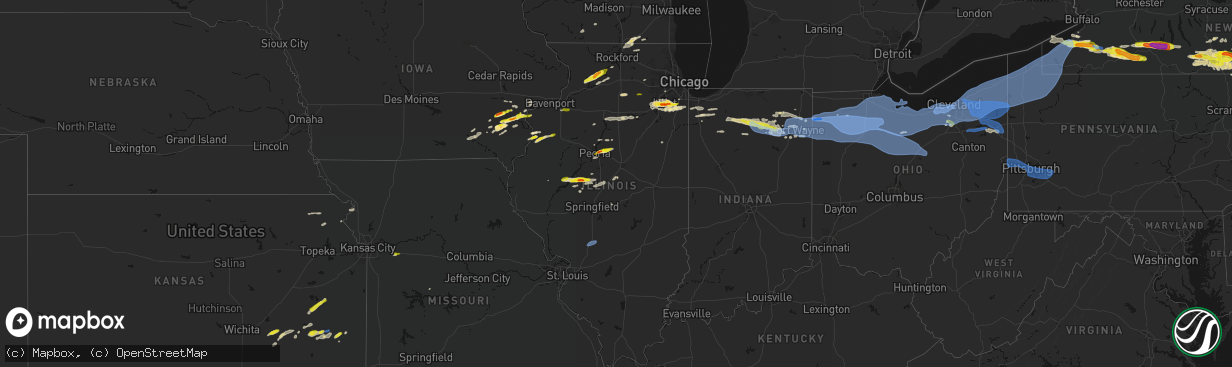
Hail Map in Illinois on March 31, 2026
The weather event in Illinois on March 31, 2026 includes Hail, Wind, and Tornado maps. 15 states and 881 cities were impacted and suffered possible damage. The total estimated number of properties impacted is 38,309.
Hail
Wind
Tornado
38,309
Estimated number of impacted properties by a 1.00" hail or larger8,231
Estimated number of impacted properties by a 1.75" hail or larger0
Estimated number of impacted properties by a 2.50" hail or largerStorm reports in Illinois
Illinois
| Date | Description |
|---|---|
| 03/31/20266:55 PM CDT | Awos station k3lf litchfield municipal airport. |
| 03/31/20262:14 PM CDT | Report relayed by broadcast media. |
| 03/31/202610:31 AM CDT | A local report indicates 1.00 inch wind near Mount Morris |
| 03/31/202610:16 AM CDT | Largest hailstone was measured to be 1.5 inches in diameter. Most hail was approximately half an inch in diameter. Time estimated from radar. |
| 03/31/20269:44 AM CDT | A local report indicates 1.25 inch wind near Eureka |
| 03/31/20269:40 AM CDT | A local report indicates 1.00 inch wind near 1 N Eureka |
| 03/31/20269:37 AM CDT | Report from mping. |
| 03/31/20269:35 AM CDT | Report from mping. |
| 03/31/20269:34 AM CDT | Multiple public reports of quarter to golf ball size hail in new lenox. Time estimated from radar. |
| 03/31/20269:34 AM CDT | Photo shared of approximately ping pong ball size hail at route 53 and laraway road. Time estimated from radar. |
| 03/31/20269:33 AM CDT | East cruger & deemack road. Delayed report. Time estimated from radar. |
| 03/31/20269:29 AM CDT | Report from mping. |
| 03/31/20269:28 AM CDT | Report from mping. |
| 03/31/20269:27 AM CDT | A local report indicates 1.75 inch wind near 1 NW Easton |
| 03/31/20269:27 AM CDT | A local report indicates 1.75 inch wind near 2 SSE Ingalls Park |
| 03/31/20269:24 AM CDT | Photo shared of hail in preston heights. The largest hailstones were approximately quarter size. Time estimated from radar. |
| 03/31/20269:21 AM CDT | Photo shared on social media showing several large hailstones at moen avenue and midland avenue in rockdale. The largest hailstones were approximately golf ball size. T |
| 03/31/20269:21 AM CDT | Report from mping. |
| 03/31/20269:18 AM CDT | Multiple trained spotter reports of dime to quarter size hail at and near joliet junior college. |
| 03/31/20269:17 AM CDT | A local report indicates 1.50 inch wind near 4 WNW Washington |
| 03/31/20269:12 AM CDT | Nickel to quarter size. |
| 03/31/20268:29 AM CDT | Time estimated from radar. |
| 03/31/20267:40 AM CDT | Passed along by broadcast media. |
| 03/31/20267:30 AM CDT | A local report indicates 1.00 inch wind near 3 E Rozetta |
All States Impacted by Hail Map on March 31, 2026
Cities Impacted by Hail Map on March 31, 2026
- Tomah, WI
- Warrens, WI
- Oakville, IA
- Brighton, IA
- Wayland, IA
- Mount Pleasant, IA
- Oquawka, IL
- Seaton, IL
- Biggsville, IL
- Gladstone, IL
- Monmouth, IL
- Camp Douglas, WI
- Batavia, IA
- Burlington, IA
- Necedah, WI
- Nekoosa, WI
- Galesburg, IL
- Alexis, IL
- Gerlaw, IL
- Columbus Junction, IA
- Compton, IL
- Paw Paw, IL
- Arkdale, WI
- Little York, IL
- Friendship, WI
- Ottumwa, IA
- Bloomfield, IA
- Letts, IA
- Earlville, IL
- Crawfordsville, IA
- Coloma, WI
- Bancroft, WI
- Westfield, WI
- Hancock, WI
- Wapello, IA
- Muscatine, IA
- Eldon, IA
- Agency, IA
- Leland, IL
- Hedrick, IA
- Wautoma, WI
- Montello, WI
- Hennepin, IL
- Princeton, IL
- Wild Rose, WI
- Bradford, IL
- Princeton, WI
- Astoria, IL
- Oglesby, IL
- Peru, IL
- Standard, IL
- Mark, IL
- Cedar Point, IL
- Granville, IL
- Tonica, IL
- Green Lake, WI
- Markesan, WI
- Washington, IA
- Fairfield, IA
- Ottawa, IL
- Marseilles, IL
- Ripon, WI
- Minooka, IL
- Havana, IL
- Bath, IL
- Oshkosh, WI
- Grand Ridge, IL
- Brandon, WI
- Sandwich, IL
- Plano, IL
- Shorewood, IL
- Joliet, IL
- Kilbourne, IL
- Easton, IL
- Washington, IL
- East Peoria, IL
- Metamora, IL
- Eldorado, WI
- Rosendale, WI
- Peoria, IL
- Chillicothe, IL
- Eureka, IL
- Pickett, WI
- Malone, WI
- Fond Du Lac, WI
- New Lenox, IL
- Mokena, IL
- Frankfort, IL
- West Chester, IA
- Lone Tree, IA
- Ainsworth, IA
- Conesville, IA
- Riverside, IA
- Roanoke, IL
- Channahon, IL
- Wallace, MI
- Mason City, IL
- Mount Calvary, WI
- Saint Cloud, WI
- Redgranite, WI
- Winfield, IA
- Manhattan, IL
- Sterling, IL
- Homer Glen, IL
- Lockport, IL
- Elwood, IL
- Matteson, IL
- New Holland, IL
- Chilton, WI
- San Jose, IL
- Elkhart Lake, WI
- Monee, IL
- University Park, IL
- Pekin, IL
- Ipava, IL
- Columbus City, IA
- Steger, IL
- Richton Park, IL
- Park Forest, IL
- Crete, IL
- Cleveland, WI
- Plymouth, WI
- Sheboygan Falls, WI
- Sheboygan, WI
- Lincoln, IL
- Elburn, IL
- Maple Park, IL
- Milledgeville, IL
- Romeoville, IL
- Plainfield, IL
- Emden, IL
- Cole Camp, MO
- Polo, IL
- Orland Park, IL
- Oregon, IL
- Atlanta, IL
- Woodridge, IL
- Franklin Grove, IL
- Ashton, IL
- Mount Morris, IL
- Lake Geneva, WI
- Fontana, WI
- Peotone, IL
- Stillman Valley, IL
- Capron, IL
- New Boston, IL
- Morning Sun, IA
- Wilton, IA
- Olds, IA
- Fruitland, IA
- Grandview, IA
- Nichols, IA
- Illinois City, IL
- Lockridge, IA
- Harvard, IL
- Dixon, IL
- Moscow, IA
- Byron, IL
- Poplar Grove, IL
- Caledonia, IL
- Clinton, WI
- Roscoe, IL
- Sharon, WI
- South Beloit, IL
- Delavan, WI
- Darien, WI
- Iowa City, IA
- Hills, IA
- West Liberty, IA
- Walworth, WI
- Argyle, WI
- Atalissa, IA
- New Glarus, WI
- Belleville, WI
- Oconomowoc, WI
- Ixonia, WI
- Watertown, WI
- Silver Creek, NY
- Dunkirk, NY
- Antwerp, OH
- Hicksville, OH
- Cecil, OH
- Mark Center, OH
- Sherwood, OH
- Ney, OH
- Defiance, OH
- Irving, NY
- Forestville, NY
- South Dayton, NY
- Perrysburg, NY
- Gowanda, NY
- Collins, NY
- Lawtons, NY
- Valders, WI
- Kiel, WI
- Manitowoc, WI
- Reedsville, WI
- Sheridan, NY
- North Collins, NY
- Angola, NY
- Saint Nazianz, WI
- Holgate, OH
- New Bavaria, OH
- Napoleon, OH
- Oakwood, OH
- Cattaraugus, NY
- East Otto, NY
- Springville, NY
- Geneseo, IL
- Osco, IL
- Continental, OH
- Hamler, OH
- Leipsic, OH
- Malinta, OH
- Liberty Center, OH
- Grelton, OH
- Grand Rapids, OH
- McClure, OH
- West Valley, NY
- Waterville, OH
- Deshler, OH
- Bowling Green, OH
- Whitehouse, OH
- Delevan, NY
- Machias, NY
- Ottawa, OH
- Weston, OH
- Miller City, OH
- Custar, OH
- Perrysburg, OH
- Tontogany, OH
- Haskins, OH
- Rudolph, OH
- Dunbridge, OH
- Milton Center, OH
- Andalusia, IL
- Taylor Ridge, IL
- Orion, IL
- Colona, IL
- Coal Valley, IL
- Crest Hill, IL
- McComb, OH
- North Baltimore, OH
- Pandora, OH
- Hoytville, OH
- Mount Cory, OH
- Cygnet, OH
- Portage, OH
- Findlay, OH
- Northwood, OH
- Walbridge, OH
- Millbury, OH
- Rossford, OH
- Maumee, OH
- Toledo, OH
- Franklinville, NY
- Rushford, NY
- Cuba, NY
- Farmersville Station, NY
- Houghton, NY
- Fillmore, NY
- Ellicottville, NY
- Swain, NY
- Dalton, NY
- Jerry City, OH
- Van Buren, OH
- Luckey, OH
- Pemberville, OH
- Arcadia, OH
- Fostoria, OH
- Bloomdale, OH
- Stony Ridge, OH
- Bradner, OH
- Risingsun, OH
- West Millgrove, OH
- Wayne, OH
- Gibsonburg, OH
- Helena, OH
- Genoa, OH
- Woodville, OH
- Williston, OH
- Curtice, OH
- Martin, OH
- Kansas, OH
- Clay Center, OH
- Dansville, NY
- Arkport, NY
- Wayland, NY
- Caneadea, NY
- Belfast, NY
- Cohocton, NY
- Burgoon, OH
- Tiffin, OH
- Fremont, OH
- Bettsville, OH
- Graytown, OH
- Elmore, OH
- Lindsey, OH
- Rocky Ridge, OH
- Oak Harbor, OH
- Angelica, NY
- Belmont, NY
- Canaseraga, NY
- Eden, NY
- Hunt, NY
- Tinley Park, IL
- Avoca, NY
- Bascom, OH
- Alvada, OH
- Almond, NY
- Prattsburgh, NY
- Bath, NY
- Country Club Hills, IL
- Friendship, NY
- Black Creek, NY
- Alfred Station, NY
- Ozark, AL
- Clopton, AL
- Skipperville, AL
- Alfred, NY
- Hornell, NY
- Hammondsport, NY
- Pulteney, NY
- Green Springs, OH
- New Riegel, OH
- Bloomville, OH
- Republic, OH
- Old Fort, OH
- Lacarne, OH
- Clyde, OH
- Milan, OH
- Castalia, OH
- Sandusky, OH
- Lakeside Marblehead, OH
- Attica, OH
- Vickery, OH
- Port Clinton, OH
- Monroeville, OH
- Bellevue, OH
- Huron, OH
- Canisteo, NY
- Newville, AL
- Andover, NY
- Scio, NY
- Saint John, IN
- Cedar Lake, IN
- Crown Point, IN
- Coffee Springs, AL
- Chancellor, AL
- Morris, IL
- Bradford, NY
- Dundee, NY
- Keuka Park, NY
- Penn Yan, NY
- Cameron, NY
- Rock Stream, NY
- Watkins Glen, NY
- New Washington, OH
- Willard, OH
- Norwalk, OH
- Plymouth, OH
- North Fairfield, OH
- Amherst, OH
- Wakeman, OH
- Lorain, OH
- Vermilion, OH
- Collins, OH
- Berlin Heights, OH
- Lowpoint, IL
- Washburn, IL
- Beecher, IL
- Merrillville, IN
- Burdett, NY
- Oberlin, OH
- Kipton, OH
- New London, OH
- Wellington, OH
- Greenwich, OH
- Elyria, OH
- Avon Lake, OH
- Sheffield Lake, OH
- Avon, OH
- North Ridgeville, OH
- Bay Village, OH
- Minonk, IL
- Valparaiso, IN
- Grafton, OH
- Lagrange, OH
- Rocky River, OH
- Olmsted Falls, OH
- North Olmsted, OH
- Columbia Station, OH
- Westlake, OH
- Lakewood, OH
- Cleveland, OH
- Brookpark, OH
- Berea, OH
- Valley City, OH
- Litchfield, OH
- Strongsville, OH
- Brunswick, OH
- Independence, OH
- Medina, OH
- North Royalton, OH
- Trumansburg, NY
- Odessa, NY
- Alpine, NY
- Abbeville, AL
- McGraw, NY
- Marathon, NY
- Cortland, NY
- Hebron, IN
- Lowell, IN
- Mclean, TX
- Cincinnatus, NY
- Broadview Heights, OH
- Hinckley, OH
- Euclid, OH
- Eastlake, OH
- Wickliffe, OH
- Kouts, IN
- Knox, IN
- Wellington, TX
- Quail, TX
- Culver, IN
- Ithaca, NY
- Plymouth, IN
- Shamrock, TX
- Hudson, OH
- Richfield, OH
- Akron, OH
- Maple Heights, OH
- Beachwood, OH
- Brecksville, OH
- Bedford, OH
- Macedonia, OH
- Northfield, OH
- Peninsula, OH
- Grand River, OH
- Solon, OH
- Mentor, OH
- Painesville, OH
- Chagrin Falls, OH
- Willoughby, OH
- Gates Mills, OH
- Twinsburg, OH
- Chesterland, OH
- Argos, IN
- Rochester, IN
- Tippecanoe, IN
- Aurora, OH
- Chardon, OH
- Novelty, OH
- Streetsboro, OH
- Cuyahoga Falls, OH
- Geneva, OH
- Madison, OH
- Thompson, OH
- Austinburg, OH
- Huntsburg, OH
- Montville, OH
- Ashtabula, OH
- Rock Creek, OH
- Mantua, OH
- Newbury, OH
- Perry, OH
- Burton, OH
- Richford, NY
- Berkshire, NY
- Mentone, IN
- Bourbon, IN
- Etna Green, IN
- Claypool, IN
- Wanatah, IN
- Ravenna, OH
- Middlefield, OH
- Windsor, OH
- West Farmington, OH
- Hiram, OH
- Rome, OH
- Garrettsville, OH
- Windham, OH
- Orwell, OH
- Jefferson, OH
- Southington, OH
- North Bloomfield, OH
- Bristolville, OH
- Conneaut, OH
- Dorset, OH
- Kingsville, OH
- North Kingsville, OH
- Burket, IN
- Silver Lake, IN
- Akron, IN
- Warsaw, IN
- Willseyville, NY
- Candor, NY
- Brooktondale, NY
- Newark Valley, NY
- Williamsfield, OH
- Cortland, OH
- Pierpont, OH
- Andover, OH
- Farmdale, OH
- Kinsman, OH
- North Springfield, PA
- West Springfield, PA
- Albion, PA
- Conneautville, PA
- Linesville, PA
- Lake City, PA
- Cranesville, PA
- Fairview, PA
- East Springfield, PA
- Girard, PA
- Springboro, PA
- Memphis, TX
- Childress, TX
- Spencer, NY
- Whitney Point, NY
- Maine, NY
- Lisle, NY
- Newfield, NY
- Greenwood, MS
- Kimmell, IN
- Albion, IN
- Pierceton, IN
- Winona Lake, IN
- Atwood, IN
- South Whitley, IN
- Larwill, IN
- Columbia City, IN
- Churubusco, IN
- Port Crane, NY
- Greene, NY
- Chenango Forks, NY
- Harpursville, NY
- Laotto, IN
- Avilla, IN
- McDonough, NY
- Castle Creek, NY
- Glen Aubrey, NY
- Binghamton, NY
- Owego, NY
- Barton, NY
- Johnson City, NY
- Atlantic, PA
- Hartstown, PA
- Conneaut Lake, PA
- Edinboro, PA
- Meadville, PA
- Harmonsburg, PA
- Adamsville, PA
- Jamestown, PA
- Greenville, PA
- Erie, PA
- Venango, PA
- Cochranton, PA
- Harborcreek, PA
- Cambridge Springs, PA
- North East, PA
- Saegertown, PA
- Waterford, PA
- McKean, PA
- Fort Wayne, IN
- Huntertown, IN
- Auburn, IN
- Garrett, IN
- Leo, IN
- Spencerville, IN
- Grabill, IN
- Harlan, IN
- Bainbridge, NY
- Afton, NY
- Endicott, NY
- Oxford, NY
- Carrollton, MS
- Sidney, NY
- Masonville, NY
- Unadilla, NY
- Hollis, OK
- Woodburn, IN
- Monroeville, IN
- New Haven, IN
- Hoagland, IN
- Payne, OH
- Paulding, OH
- Convoy, OH
- Tell, TX
- Vestal, NY
- Windsor, NY
- Kirkwood, NY
- Ouaquaga, NY
- Grenada, MS
- Sidney Center, NY
- Walton, NY
- Grover Hill, OH
- Latty, OH
- Scott, OH
- Haviland, OH
- Van Wert, OH
- Melrose, OH
- Cloverdale, OH
- Franklin, NY
- Erick, OK
- Coffeeville, MS
- Nineveh, NY
- Conklin, NY
- Fort Jennings, OH
- Middle Point, OH
- Ottoville, OH
- Delphos, OH
- Kalida, OH
- Hamden, NY
- Delhi, NY
- Delancey, NY
- Deposit, NY
- North Manchester, IN
- Guilford, NY
- Winamac, IN
- Medaryville, IN
- Vinson, OK
- Gould, OK
- South Plymouth, NY
- Norwich, NY
- North Judson, IN
- Paducah, TX
- Columbus Grove, OH
- Vaughnsville, OH
- Huntington, IN
- East Branch, NY
- Derby, NY
- Hancock, NY
- Ashkum, IL
- Francesville, IN
- Liberty Mills, IN
- Mount Olive, IL
- Litchfield, IL
- Butler, IL
- Hillsboro, IL
- Wattsburg, PA
- Guys Mills, PA
- Corry, PA
- Centerville, PA
- Townville, PA
- Spartansburg, PA
- Union City, PA
- Spring Creek, PA
- Bear Lake, PA
- Columbus, PA
- Sugar Grove, PA
- Clymer, NY
- Pittsfield, PA
- Westfield, NY
- Mayville, NY
- Stockton, NY
- Stow, NY
- Ripley, NY
- Cassadaga, NY
- Fredonia, NY
- Lakewood, NY
- Bemus Point, NY
- Van Buren Point, NY
- Sherman, NY
- Sinclairville, NY
- Brocton, NY
- Chautauqua, NY
- Ashville, NY
- Portland, NY
- Panama, NY
- Dewittville, NY
- Jamestown, NY
- Findley Lake, NY
- Susquehanna, PA
- Downsville, NY
- Roanoke, IN
- Cherry Creek, NY
- Lily Dale, NY
- Celoron, NY
- Gerry, NY
- Titusville, PA
- Hydetown, PA
- Grand Valley, PA
- Cooperstown, PA
- Youngsville, PA
- Garland, PA
- Andes, NY
- Roscoe, NY
- Margaretville, NY
- Livingston Manor, NY
- Arkville, NY
- Fleischmanns, NY
- Cromwell, IN
- Yoder, IN
- North Webster, IN
- Warren, OH
- Leavittsburg, OH
- Fowler, OH
- Burghill, OH
- Bluffton, OH
- Rawson, OH
- Benton Ridge, OH
- Jenera, OH
- Forest, OH
- Carey, OH
- Arlington, OH
- Mount Blanchard, OH
- Vanlue, OH
- Kewanna, IN
- Mangum, OK
- Leesburg, IN
- Kirby, OH
- Sycamore, OH
- Wharton, OH
- Upper Sandusky, OH
- McCutchenville, OH
- Fishs Eddy, NY
- Long Eddy, NY
- Neversink, NY
- Woodbourne, NY
- Liberty, NY
- Grahamsville, NY
- Parksville, NY
- Claryville, NY
- Toronto, KS
- Fredonia, KS
- Napanoch, NY
- Kerhonkson, NY
- West Shokan, NY
- Olivebridge, NY
- Newton Falls, OH
- North Jackson, OH
- Youngstown, OH
- Mineral Ridge, OH
- Niles, OH
- McDonald, OH
- Girard, OH
- Blair, OK
- Granite, OK
- Wadsworth, OH
- Lone Wolf, OK
- Yates Center, KS
- Canfield, OH
- Crowell, TX
- Bucyrus, OH
- Nevada, OH
- Harpster, OH
- Morral, OH
- Crestline, OH
- Shelby, OH
- Tiro, OH
- Caledonia, OH
- Chatfield, OH
- Galion, OH
- Marion, OH
- Mansfield, OH
- Shiloh, OH
- Nova, OH
- Ashland, OH
- Lucas, OH
- Quanah, TX
- Demotte, IN
- Struthers, OH
- Campbell, OH
- Piedmont, KS
- Lake Milton, OH
- Diamond, OH
- Berlin Center, OH
- Howard, KS
- Chillicothe, TX
- Severy, KS
- Fall River, KS
- Atlanta, KS
- Leon, KS
- Latham, KS
- Niantic, IL
- Spur, TX
- Benedict, KS
- Dickens, TX
- Cambridge, KS
- Burden, KS
- Beaumont, KS
- Buffalo, KS
- Gridley, KS
- Le Roy, KS
- Burlington, KS
- Chanute, KS
- Seymour, TX
- Altoona, KS
- Old Glory, TX
- Aspermont, TX
- Westphalia, KS
- Holton, KS
- Munday, TX
- Pittsburgh, PA
- Monroeville, PA
- Coraopolis, PA
- Bulger, PA
- East Pittsburgh, PA
- Buena Vista, PA
- New Stanton, PA
- Imperial, PA
- Claridge, PA
- East McKeesport, PA
- Herminie, PA
- Bethel Park, PA
- Crescent, PA
- Sewickley, PA
- Harrison City, PA
- Wilmerding, PA
- Darragh, PA
- Greensburg, PA
- Mckeesport, PA
- Turtle Creek, PA
- Glassport, PA
- Murrysville, PA
- Dravosburg, PA
- Aliquippa, PA
- Elizabeth, PA
- Pitcairn, PA
- West Mifflin, PA
- Westmoreland City, PA
- Duquesne, PA
- Oakdale, PA
- South Park, PA
- Delmont, PA
- North Versailles, PA
- McKees Rocks, PA
- Greenock, PA
- Trafford, PA
- Carnegie, PA
- Clairton, PA
- Ardara, PA
- Georgetown, PA
- Manor, PA
- Clinton, PA
- Hookstown, PA
- Export, PA
- Penn, PA
- Larimer, PA
- Braddock, PA
- Adamsburg, PA
- Irwin, PA
- Rillton, PA
- Jeannette, PA
- Burgettstown, PA
- Homestead, PA
- Arona, PA
- Grapeville, PA
- Muscotah, KS
- Erie, KS
- Thayer, KS
- Goree, TX
- Walnut, KS
- New Alexandria, PA
- Forbes Road, PA
- Green Valley, IL
- Littleton, IL
- McLean, IL
- Wathena, KS
- Waynesville, IL
- Saint Joseph, MO
- Hartsburg, IL
- Atchison, KS
- Elwood, KS
- Powhattan, KS
- Netawaka, KS
- Wetmore, KS
- Saint Paul, KS
- Horton, KS
- Corunna, IN
- Petersburg, IL
- Odessa, MO
- Arcola, IN
- Perrysville, OH
- Loudonville, OH
- Tallmadge, OH
- Atwater, OH
- Kent, OH
- Mogadore, OH
- Rootstown, OH


