Hail Map in Georgia on April 25, 2015
The weather event in Georgia on April 25, 2015 includes Hail map. 16 states and 433 cities were impacted and suffered possible damage. The total estimated number of properties impacted is 16,917.
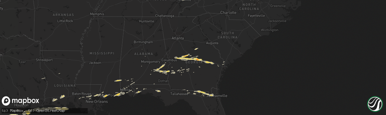
Hail
16,917
Estimated number of impacted properties by a 1.00" hail or larger3,637
Estimated number of impacted properties by a 1.75" hail or larger2,444
Estimated number of impacted properties by a 2.50" hail or largerStorm reports in Georgia
Georgia
| Date | Description |
|---|---|
| 04/25/20156:57 PM CDT | Numerous trees were blown down countywide. Some were blown onto roads. |
| 04/25/20156:56 PM CDT | Tree down across donnell rd. Time estimated from radar |
| 04/25/20156:55 PM CDT | Spotter estimated wind gusts near 60 mph near highway 270 and highway 33 |
| 04/25/20156:52 PM CDT | Strong winds blew down large tree limbs which damaged a metal fence on gander lane. Public post to walb-tv facebook page. |
| 04/25/20156:52 PM CDT | Numerous trees and power lines down across the county |
| 04/25/20156:50 PM CDT | Large tree snapped along green street near the train tracks in doerun. |
| 04/25/20156:48 PM CDT | Tree and power line down in sumner |
| 04/25/20156:47 PM CDT | Tree down in the eastern part of mitchell county close to the border with colquitt county |
| 04/25/20156:30 PM CDT | Several trees and power lines down around baker county |
| 04/25/20156:30 PM CDT | Several trees down around ashburn |
| 04/25/20156:22 PM CDT | Em reported numerous trees down south of dublin south of i-16. |
| 04/25/20156:17 PM CDT | Several trees and power lines down around miller county |
| 04/25/20156:15 PM CDT | Couple of trees down around albany |
| 04/25/20156:12 PM CDT | Numerous trees were blown down countywide. Some were blown onto roads. |
| 04/25/20156:11 PM CDT | Emergency manager reports numerous trees and powerlines down across the county. At least one tree is on a house. |
| 04/25/20156:08 PM CDT | Numerous trees and power lines down across early county |
| 04/25/20156:07 PM CDT | Tree down in oakfield |
| 04/25/20156:02 PM CDT | A large tree was snapped near its base on east bob white road in kathleen. |
| 04/25/20155:57 PM CDT | Several trees were blown down in the lake joy and houston lake area. |
| 04/25/20155:55 PM CDT | Several trees and power lines down in the county with some trees uprooted. Also roof off a county building in downtown. |
| 04/25/20155:52 PM CDT | Strong winds blew down large tree limbs which damaged a metal fence on gander lane. Public post to walb-tv facebook page. |
| 04/25/20155:50 PM CDT | 911 reports trees down trhoughout the county with the greatest concentration just north of leslie. |
| 04/25/20155:50 PM CDT | Trees and power lines down in clay county |
| 04/25/20155:47 PM CDT | 20-30 pecan trees uprooted near valley view drive and state hwy 96 in fort valley. Power lines were also down in the area and there was a report of light standards blow |
| 04/25/20155:42 PM CDT | Baseball sized hail fell on academy avenue extension in dublin. Photo relayed on social media. |
| 04/25/20155:40 PM CDT | Power line down along sellers road |
| 04/25/20155:36 PM CDT | Tree down on highway 257 near west laurens high school. |
| 04/25/20155:35 PM CDT | Trees down around dawson |
| 04/25/20155:33 PM CDT | Photo of golfball sized hail on social media. |
| 04/25/20155:31 PM CDT | Social media picture of several golf ball sized hail stones on hartley bridge rd. |
| 04/25/20155:25 PM CDT | Tree down across a road in shellman |
| 04/25/20155:25 PM CDT | Golf ball sized hail was falling on richardson mill road. |
| 04/25/20155:19 PM CDT | A large tree fell on a shed on ed davis rd. |
| 04/25/20155:12 PM CDT | A large tree was blown down in fort valley. Photo from social media. |
| 04/25/20155:12 PM CDT | Quarter size hail reported by fire dept in montrose. |
| 04/25/20155:08 PM CDT | A tree was blown down onto powerlines on buena vista rd near holly hills. |
| 04/25/20155:07 PM CDT | A large tree was uprooted on charles drive in fort valley. |
| 04/25/20155:05 PM CDT | Trees and power lines down. |
| 04/25/20154:55 PM CDT | Quarter size hail in pataula creek between ft. Gaines and georgetown. Public report to wtvy-tv facebook. |
| 04/25/20154:45 PM CDT | Trees and power lines down in quitman county |
| 04/25/20154:45 PM CDT | A tree was blown down on lake joy road. |
| 04/25/20154:35 PM CDT | 911 center reports numerous trees and powerlines down throughout the county with greatest concentration near butler. |
| 04/25/20159:27 AM CDT | 35 to 40 trees down county wide. Time estimated from radar. |
| 04/25/20158:36 AM CDT | Several large oak trees were brought down along with an additional number of pines along interstate 16...near mm 58 - hwy 199. Time estimated from radar. Follow-up repo |
| 04/24/20159:12 PM CDT | Tree down at intersection of swamp rd and ga hwy 99 |
| 04/24/20159:06 PM CDT | Tree down across johnson rd near ga hwy 99 |
| 04/24/20158:31 PM CDT | Tybee north weatherflow sensor |
| 04/24/20158:25 PM CDT | South tybee island weatherflow sensor |
| 04/24/20158:24 PM CDT | Tree down on tibet rd |
| 04/24/20158:22 PM CDT | Roof damaged at a nursing home in midway. Evacuations were necessary. Time estimated based on radar. |
| 04/24/20158:19 PM CDT | Trees down on limerick road. Time estimated based on radar. |
| 04/24/20158:15 PM CDT | Wayne county 911/dispatch reports numerous trees and powerlines down county-wide. |
| 04/24/20158:15 PM CDT | A tree was blown down on wilmington island along north cromwell road. Time was estimated from radar data. |
| 04/24/20158:09 PM CDT | Tree down on house. Report via facebook |
| 04/24/20158:08 PM CDT | Trees were blown down at scattered locations along skidaway road between virginia avenue and 41st street. Time was estimated from radar data. |
| 04/24/20158:06 PM CDT | Large gas station awning covering gas pumps blown down on waters avenue. Time estimated based on radar. |
| 04/24/20158:05 PM CDT | A tree was blown onto power lines at the intersection of bull street and thackery place. Time was estimated from radar data. |
| 04/24/20158:04 PM CDT | *** 1 inj *** tree fell down on a house on west street causing one injury to a female. |
| 04/24/20158:03 PM CDT | Thunderstorm winds blew a tree onto a vehicle at the intersection of ogeechee road and kollock street. Time was estimated from radar data. |
| 04/24/20158:03 PM CDT | Trees were blown down at scattered locations along ogeechee road between 37th street and corvair street. Time was estimated from radar data. |
| 04/24/20158:02 PM CDT | Multiple trees were blown down in the garden city vicinity. Time was estimated radar data. |
| 04/24/20158:01 PM CDT | Shipping crane tipped over at the georgia ports authority. |
| 04/24/20158:01 PM CDT | Multiple trees were blown down in the port wentworth vicinity. Time was estimated from radar data. |
| 04/24/20158:01 PM CDT | Two trees were blown down along state route 21 between gulfstream road and grange road. Time was estimated from radar data. |
| 04/24/20158:01 PM CDT | A peak wind gust of 91 mph was observed on an elevated crane at the georgia ports authority. |
| 04/24/20158:00 PM CDT | Multiple trees and powerlines down on coleraine dr |
| 04/24/20158:00 PM CDT | Several aircraft were damaged by thunderstorm winds in the general aviation section of savannah airport. A wind gust to 81 mph was measured at the airport. |
| 04/24/20158:00 PM CDT | Ksav reported peak wind of 70 kt....81 mph |
| 04/24/20158:00 PM CDT | Multiple trees down...some newly planted...in new tangier outlet parking lot. At least one tree on car |
| 04/24/20158:00 PM CDT | Multiple trees down on houses and power lines near cliff dr in pooler |
| 04/24/20158:00 PM CDT | Trees were blown down onto interstate 95 between mile markers 106 and 109. Time was estimated from radar data. |
| 04/24/20158:00 PM CDT | Multiple trees down on wyndham rd in the forest lakes subdivision |
| 04/24/20157:59 PM CDT | Tree down blocking northbound lanes of interstate 95 near ga tech campus |
| 04/24/20157:52 PM CDT | Trees were blown down at scattered locations along bloomingdale road between the interstate 16 interchange and pine barren road. Time was estimated from radar data. |
| 04/24/20157:50 PM CDT | Trees were reported down on boxankle rd |
| 04/24/20157:48 PM CDT | Trees and debris in road at zeigler road and kathy street. Time estimated based on radar. |
| 04/24/20157:48 PM CDT | Numerous trees down on power lines and across roads around eden |
| 04/24/20157:48 PM CDT | Large distribution power lines blown down. Multiple large trees down on highway 30 and noel conaway road near buckingham drive. |
| 04/24/20157:47 PM CDT | Tree down on highway 119 near the bulloch county border. |
| 04/24/20157:45 PM CDT | Large trees blown down in a neighborhood off old oak road. |
| 04/24/20157:45 PM CDT | Large trees blown down in a neighborhood off brittany lane. |
| 04/24/20157:45 PM CDT | Trees and power lines down near the intersection of roebling rd and rt 17 |
| 04/24/20157:45 PM CDT | Power lines down at highway 17 south and blue jay road. Time estimated based on radar. |
| 04/24/20157:43 PM CDT | Multiple trees and power lines down at holly circle. Time estimated based on radar. |
| 04/24/20157:43 PM CDT | Multiple trees down across roads on south side of guyton |
| 04/24/20157:40 PM CDT | Appling county 911/dispatch reports a tree down along miles chapel church road. Time of damage based on radar data. |
| 04/24/20157:40 PM CDT | Tree down on arcola rd. Near black creek church rd. |
| 04/24/20157:35 PM CDT | Tree down on house on 100 block smith ave |
| 04/24/20157:35 PM CDT | Tree down on mud rd. Near black creek church rd. |
| 04/24/20157:33 PM CDT | Tree down on highway 46 near brooklet denmark rd. |
| 04/24/20157:33 PM CDT | Tree down across hutcheson rd |
| 04/24/20157:32 PM CDT | Numerous trees down across the county including in lyons. |
| 04/24/20157:30 PM CDT | Atkinson county 911/dispatch reports trees downed near the intersection of highway 135 north and antioch church road and also along kirkland pond road. Time of damage b |
| 04/24/20157:30 PM CDT | Tree down on highway 46 near trapnell rd. |
| 04/24/20157:30 PM CDT | Tree down on highway 67 near mile marker 12. |
| 04/24/20157:27 PM CDT | Trees down around nashville |
| 04/24/20157:25 PM CDT | Jeff davis county 911/dispatch reports trees downed along atlantic street...near the intersection of south miller street and charles rogers boulevard...and a powerline |
| 04/24/20157:23 PM CDT | Trees down around alapaha |
| 04/24/20157:22 PM CDT | Tree down near the intersection of arcola rd and black creek ch rd. Time estimated from radar |
| 04/24/20157:14 PM CDT | Tree down on ashbranch church rd. Between i-16 and lawrence church rd. |
| 04/24/20157:12 PM CDT | Tree down near intersection of highway 67 and emit grove rd. Time estimated from radar |
| 04/24/20157:10 PM CDT | Trees and power lines down around the county |
| 04/24/20157:06 PM CDT | Trees down across telfair county with the highest concentration near workmore. |
| 04/24/20157:05 PM CDT | Numerous trees and power lines down around the county |
| 04/24/20157:00 PM CDT | Trees down on votech drive. |
| 04/24/20157:00 PM CDT | Couple of trees down around tifton |
All States Impacted by Hail Map on April 25, 2015
Cities Impacted by Hail Map on April 25, 2015
- Linefork, KY
- Hallie, KY
- Greenville, FL
- Diamondhead, MS
- Waveland, MS
- Bay Saint Louis, MS
- Bryceville, FL
- Jacksonville, FL
- Lake City, FL
- White Springs, FL
- Jasper, FL
- Knoxville, TN
- Fort Gaines, GA
- Eufaula, AL
- Abbeville, AL
- Georgetown, GA
- Morris, GA
- Oelrichs, SD
- Chadron, NE
- Fairhope, AL
- Coal City, WV
- Princewick, WV
- McKee, KY
- Mount Vernon, KY
- Lancaster, KY
- Harrodsburg, KY
- Sandgap, KY
- Danville, KY
- Perryville, KY
- Stanford, KY
- Paint Lick, KY
- Berea, KY
- Brodhead, KY
- Crab Orchard, KY
- Lisco, NE
- Cochran, GA
- Dry Branch, GA
- Moss Point, MS
- Gautier, MS
- Bardstown, KY
- Bloomfield, KY
- Springfield, KY
- Willisburg, KY
- Dudley, GA
- Dublin, GA
- Rentz, GA
- Dexter, GA
- Equality, IL
- Raleigh, IL
- Ridgway, IL
- Eldorado, IL
- Sebree, KY
- Robards, KY
- Partridge, KY
- Whitesburg, KY
- Ocean Springs, MS
- Pascagoula, MS
- Milledgeville, GA
- Sparta, GA
- Hilton Head Island, SC
- Bluffton, SC
- Clio, AL
- Louisville, AL
- Clayton, AL
- Sweeny, TX
- Van Vleck, TX
- Coden, AL
- Bayou La Batre, AL
- Theodore, AL
- Irvington, AL
- Edna, TX
- East Dublin, GA
- Utica, KY
- Calhoun, KY
- Owensboro, KY
- Ponchatoula, LA
- Saint Amant, LA
- Maurepas, LA
- Springfield, LA
- Metter, GA
- Claxton, GA
- Register, GA
- Wooton, KY
- Fort Knox, KY
- Happy, KY
- Letcher, KY
- Mackville, KY
- Tyner, KY
- Sassafras, KY
- Busy, KY
- Burgin, KY
- Bonnyman, KY
- Eolia, KY
- Gays Creek, KY
- Buckhorn, KY
- Thousandsticks, KY
- Shepherdsville, KY
- Guston, KY
- Mistletoe, KY
- Vincent, KY
- Scuddy, KY
- Smilax, KY
- Viper, KY
- Boston, KY
- Vicco, KY
- Richmond, KY
- Chavies, KY
- Ekron, KY
- Coxs Creek, KY
- Bulan, KY
- Clermont, KY
- Ricetown, KY
- West Point, KY
- Combs, KY
- Cornettsville, KY
- Brandenburg, KY
- Lebanon Junction, KY
- Oneida, KY
- Hazard, KY
- Orlando, KY
- Irvine, KY
- Muldraugh, KY
- Krypton, KY
- Blackey, KY
- Roxana, KY
- Jeff, KY
- Booneville, KY
- Appalachia, VA
- Laconia, IN
- Big Creek, KY
- Hyden, KY
- Pembroke, GA
- Wise, VA
- Norton, VA
- Loretto, KY
- Lebanon, KY
- Bell City, LA
- Lake Arthur, LA
- Lacassine, LA
- Cameron, LA
- Iowa, LA
- Lake Charles, LA
- Welsh, LA
- Mauk, GA
- Junction City, GA
- Fort Valley, GA
- Reynolds, GA
- Butler, GA
- Simpsonville, KY
- Shelbyville, KY
- Blessing, TX
- Louise, TX
- Midfield, TX
- Bay City, TX
- Markham, TX
- Ellabell, GA
- Hitchcock, TX
- Knoxville, GA
- Macon, GA
- Byron, GA
- Roberta, GA
- Lizella, GA
- Cleveland, VA
- Honaker, VA
- Galatia, IL
- Pledger, TX
- Boling, TX
- Wharton, TX
- West Columbia, TX
- El Campo, TX
- Damon, TX
- Banks, AL
- Troy, AL
- Midway, AL
- Brenton, WV
- Pineville, WV
- Harrison, NE
- Chester, GA
- Danville, GA
- Swainsboro, GA
- Perry, GA
- Warner Robins, GA
- Bonaire, GA
- Lyons, GA
- Rockledge, GA
- Tarrytown, GA
- Soperton, GA
- Cobbtown, GA
- Kathleen, GA
- Montrose, GA
- Box Springs, GA
- Collins, GA
- Marshallville, GA
- Talbotton, GA
- Vidalia, GA
- Jeffersonville, GA
- Daphne, AL
- Silverhill, AL
- Loxley, AL
- Lebanon, VA
- Rosedale, VA
- Saltville, VA
- Little River, AL
- Jackson, AL
- Macedonia, IL
- Uniontown, KY
- Harrisburg, IL
- Junction, IL
- Omaha, IL
- Thompsonville, IL
- Morganfield, KY
- Shawneetown, IL
- Waverly, KY
- Louisville, KY
- Lolita, TX
- Grand Bay, AL
- Glen Fork, WV
- Cedar Bluff, VA
- Sidney, NE
- Lodgepole, NE
- Kaplan, LA
- Hardeeville, SC
- Golconda, IL
- Eddyville, IL
- Simpson, IL
- Cuthbert, GA
- Shellman, GA
- Fredonia, KY
- Princeton, KY
- Nortonville, KY
- Crofton, KY
- Dawson Springs, KY
- Saint Charles, KY
- Marion, KY
- North Spring, WV
- Iaeger, WV
- Hanover, WV
- La Marque, TX
- Texas City, TX
- Galveston, TX
- Leesburg, GA
- Slidell, LA
- Minter, AL
- Egan, LA
- Morse, LA
- Meadowview, VA
- Peetz, CO
- Mandeville, LA
- Pearlington, MS
- Pass Christian, MS
- Lee, FL
- Macclenny, FL
- Saint George, GA
- Hampton, KY
- Salem, KY
- Burna, KY
- Iliff, CO
- Crook, CO
- Fitzgerald, GA
- Clintwood, VA
- Coeburn, VA
- Marion, VA
- McClure, VA
- Dante, VA
- Nora, VA
- Clinchco, VA
- Davenport, VA
- Castlewood, VA
- Pound, VA
- Glade Spring, VA
- Cordele, GA
- De Soto, GA
- Leslie, GA
- Jackson, KY
- Whick, KY
- Milton, FL
- Irvington, KY
- Rayne, LA
- Crowley, LA
- Crandall, IN
- Georgetown, IN
- Corydon, IN
- Richmond, TX
- Needville, TX
- Abbeville, LA
- White Castle, LA
- Slab Fork, WV
- Rhodell, WV
- Lost Creek, KY
- Iota, LA
- Branch, LA
- Lacombe, LA
- Pearl River, LA
- Uriah, AL
- Brush, CO
- Manchester, KY
- Angleton, TX
- Boston, GA
- Maceo, KY
- Philpot, KY
- Lewisport, KY
- Missouri City, TX
- Rosharon, TX
- La Place, LA
- Shorterville, AL
- Leakesville, MS
- Vernon, FL
- Chipley, FL
- Santa Fe, TX
- Port Bolivar, TX
- Oakfield, GA
- Pensacola, FL
- Ashburn, GA
- Smithland, KY
- McIntosh, AL
- Glen Saint Mary, FL
- Sanderson, FL
- Vinegar Bend, AL
- Sedgwick, CO
- Fleming, CO
- Hay Springs, NE
- Rushville, NE
- Shady Spring, WV
- Cool Ridge, WV
- Clopton, AL
- Hurtsboro, AL
- Union Springs, AL
- Hatchechubbee, AL
- Pittsview, AL
- Brundidge, AL
- Saint Gabriel, LA
- Geismar, LA
- Donaldsonville, LA
- Carville, LA
- Billingsley, AL
- Pleasant Hill, IL
- Holt, FL
- Baker, FL
- Clinton, TN
- Powell, TN
- Heiskell, TN
- Cumberland, KY
- Murphysboro, IL
- Ava, IL
- Smithville, GA
- Crestview, FL
- Ganado, TX
- Arabi, GA
- Albany, GA
- Dawson, GA
- Bronwood, GA
- Atmore, AL
- Bay Minette, AL
- Perdido, AL
- Richland, GA
- Lumpkin, GA
- Pitts, GA
- Mobile, AL
- Vancleave, MS
- Jennings, FL
- Port Wentworth, GA
- Long Beach, MS
- Plaquemine, LA
- Deer Park, AL
- Neely, MS
- Atlanta, LA
- Dry Prong, LA
- Colfax, LA
- Brantley, AL
- Luverne, AL
- Gonzales, LA
- Hemphill, TX
- Carriere, MS
- Picayune, MS
- Rincon, GA
- Grantsburg, IL
- Brazoria, TX
- Saulsville, WV
- Simon, WV
- Ikes Fork, WV
- Davy, WV
- Stonefort, IL
- Irwinton, GA
- Ponce De Leon, FL
- Caryville, FL
- Delphia, KY
- Slemp, KY
- Yeaddiss, KY
- Gordon, KY
- Eight Mile, AL
- Montevallo, AL
- Seale, AL
- Littcarr, KY
- Mallie, KY
- Pine Top, KY
- Oliver Springs, TN
- Wartburg, TN
- Robertsdale, AL
- Stennis Space Center, MS
- Mermentau, LA
- Evangeline, LA
- Jennings, LA
- Estherwood, LA
- Alvin, TX
- Liverpool, TX
- Jenkins, KY
- Beasley, TX
- Oak Ridge, TN
- McRae Helena, GA
- Broughton, IL
- Johnston City, IL
- Corydon, KY
- Sturgis, KY
- West Frankfort, IL
- Benton, IL
- Pittsburg, IL
- Marion, IL
- Ellsworth, NE
- Americus, GA
- Du Quoin, IL
- Freeport, TX
- Saint Paul, VA
- Thomasville, GA
- Samson, AL
- Padroni, CO
- Coleman, GA
- Live Oak, FL
- Elizabethtown, KY
- Mayking, KY
- Premium, KY
- Beattyville, KY
- Jeremiah, KY
- Webster, KY


