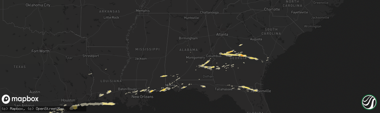
Hail Map in Alabama on April 25, 2015
The weather event in Alabama on April 25, 2015 includes Hail map. 16 states and 433 cities were impacted and suffered possible damage. The total estimated number of properties impacted is 858.
Hail
858
Estimated number of impacted properties by a 1.00" hail or larger0
Estimated number of impacted properties by a 1.75" hail or larger0
Estimated number of impacted properties by a 2.50" hail or largerStorm reports in Alabama
Alabama
| Date | Description |
|---|---|
| 04/25/20155:55 PM CDT | Social media report of numerous trees and power lines down in columbia |
| 04/25/20155:50 PM CDT | Social media report of trees down on ludlam road |
| 04/25/20155:50 PM CDT | Numerous trees down around the webb area along highway 52. Trees snapped 6 to 8 feet up |
| 04/25/20155:48 PM CDT | Trees down on highway 10 east |
| 04/25/20155:48 PM CDT | Trees down on county road 55 |
| 04/25/20155:48 PM CDT | Trees down on county road 49 |
| 04/25/20155:48 PM CDT | Trees down on county road 6 |
| 04/25/20155:47 PM CDT | Gas station awning damaged along old us 84. Report and picture via wdhn-tv. |
| 04/25/20155:47 PM CDT | Large tree and power lines across prevatt road in ashford. Public report to wtvy-tv facebook page. |
| 04/25/20155:45 PM CDT | Multiple trees blown down in the headland area. Wooden swing set blown into a fence. Public post to wtvy-tv facebook page. |
| 04/25/20155:45 PM CDT | Multiple trees and power lines down around cowarts. Public report to wtvy-tv facebook page. |
| 04/25/20155:42 PM CDT | Large oak tree snapped in kinsey. Picture posted to wtvy-tv facebook page. |
| 04/25/20155:42 PM CDT | Large tree downed...report and damage picture via social media. Time estimated from radar. |
| 04/25/20155:41 PM CDT | Large pine tree snappped and fell into aberdeen road. Picture via wdhn-tv facebook. |
| 04/25/20155:40 PM CDT | Numerous additional reports of trees and power lines down across dothan...with some damage to a few carports or outbuildings...and some houses and cars due to falling t |
| 04/25/20155:40 PM CDT | Two trees down and a power pole down on tate drive near rip hewes stadium in dothan. Public report to the wtvy-tv facebook page. |
| 04/25/20155:40 PM CDT | Social media report of a large tree on a house on church street with a car demolished |
| 04/25/20155:39 PM CDT | Large awning blown into the median of ross tucker circle from a nearby structure. Picture via wdhn-tv facebook. |
| 04/25/20155:39 PM CDT | Large tree down across timbers drive southwest of dothan. Per public picture post to wdhn-tv facebook. |
| 04/25/20155:38 PM CDT | Multiple trees snapped and uprooted in the rehobeth area. Pictures posted to wtvy-tv facebook. |
| 04/25/20155:35 PM CDT | 59 mph wind gust measured at the dothan airport asos. |
| 04/25/20155:30 PM CDT | Tree down on a fence on wicksburg road by allen stagefield |
| 04/25/20155:30 PM CDT | Large tree snapped in slocomb. Report to the wtvy-tv facebook page. |
| 04/25/20155:25 PM CDT | Social media report of several trees down on homes in hartford |
| 04/25/20155:25 PM CDT | Numerous trees and power lines down in dale county |
| 04/25/20155:23 PM CDT | Mobile home trailer blown onto its side between hartford and wicksburg. Reported by wdhn reporter. |
| 04/25/20155:18 PM CDT | Barn destroyed on county rd 35 |
| 04/25/20155:15 PM CDT | Measured 58.25 mph gust at a university of south alabama mesonet site in geneva. |
| 04/25/20155:15 PM CDT | Tree down on highway 27 north. |
| 04/25/20155:15 PM CDT | Tree down. |
| 04/25/20155:15 PM CDT | Numerous trees down around geneva county and the city of geneva...reported by county em. Wdhn-tv also posted photos of several large trees down in the city of geneva an |
| 04/25/20155:15 PM CDT | Tree down on highway 27 between enterprise and ozark. Public report to wtvy-tv facebook page. |
| 04/25/20155:10 PM CDT | Numerous trees and power lines down |
| 04/25/20155:05 PM CDT | Social media report and picture of a tree down on a pickup near hacoda |
| 04/25/20154:44 PM CDT | Two to three dozen trees down in the seale area with some minor damage to outbuildings as well. The main damage was concentrated to the dudley loop and bush rd intersec |
| 04/25/20154:35 PM CDT | Asos at andalusia airforce base recorded a 61mph wind gust. |
| 04/25/20154:05 PM CDT | Single tree down in two locations in midway |
| 04/25/20154:05 PM CDT | One tree down and some large limbs down along highways 97 and 37. Time estimated from radar. Winds estimated 40 to 50 mph. Corrected report. |
| 04/25/20153:40 PM CDT | Trained spotter reports trees down and structural damagage to houses in the rosinton area. |
| 04/25/20153:35 PM CDT | Off duty nws employee estimates 60mph winds. Time estimated from radar. |
| 04/25/20153:31 PM CDT | Large 40-50 foot tall large diameter trees reported down in the silver hill community. Time estimated via radar. |
| 04/25/20153:24 PM CDT | Multiple trees down along wood acres rd. |
| 04/25/20153:20 PM CDT | South alabama mesonet in fairhope recorded a 58mph wind gust associated with severe storms. |
| 04/25/20153:07 PM CDT | Tree down in roadway on bear fork rd near moffett rd. Report relayed via social media. |
| 04/25/20153:07 PM CDT | Large tree felled on the campus of the university of south alabama. Report relayed via social media. |
| 04/25/20153:07 PM CDT | Public reports a large tree down on grand bay wilmer rd near sams super burger. Report relayed via social media. |
| 04/25/20153:05 PM CDT | Large trees down near the town of excel. Time estimated from radar. |
| 04/25/20153:00 PM CDT | Large tree down...broken at trunk at grand bay-wilmer and interstate 10. |
| 04/25/20152:59 PM CDT | Power lines down on wilmer rd near tanner williams rd. Report relayed via social media. |
| 04/25/20152:56 PM CDT | Public reports power lines down along mccrary rd between spice pond and lott roads. Report relayed via social media. |
| 04/25/20151:52 PM CDT | Large tree down across hwy 45 north of deer park. Time estimated from radar. |
All States Impacted by Hail Map on April 25, 2015
Cities Impacted by Hail Map on April 25, 2015
- Linefork, KY
- Hallie, KY
- Greenville, FL
- Diamondhead, MS
- Waveland, MS
- Bay Saint Louis, MS
- Bryceville, FL
- Jacksonville, FL
- Lake City, FL
- White Springs, FL
- Jasper, FL
- Knoxville, TN
- Fort Gaines, GA
- Eufaula, AL
- Abbeville, AL
- Georgetown, GA
- Morris, GA
- Oelrichs, SD
- Chadron, NE
- Fairhope, AL
- Coal City, WV
- Princewick, WV
- McKee, KY
- Mount Vernon, KY
- Lancaster, KY
- Harrodsburg, KY
- Sandgap, KY
- Danville, KY
- Perryville, KY
- Stanford, KY
- Paint Lick, KY
- Berea, KY
- Brodhead, KY
- Crab Orchard, KY
- Lisco, NE
- Cochran, GA
- Dry Branch, GA
- Moss Point, MS
- Gautier, MS
- Bardstown, KY
- Bloomfield, KY
- Springfield, KY
- Willisburg, KY
- Dudley, GA
- Dublin, GA
- Rentz, GA
- Dexter, GA
- Equality, IL
- Raleigh, IL
- Ridgway, IL
- Eldorado, IL
- Sebree, KY
- Robards, KY
- Partridge, KY
- Whitesburg, KY
- Ocean Springs, MS
- Pascagoula, MS
- Milledgeville, GA
- Sparta, GA
- Hilton Head Island, SC
- Bluffton, SC
- Clio, AL
- Louisville, AL
- Clayton, AL
- Sweeny, TX
- Van Vleck, TX
- Coden, AL
- Bayou La Batre, AL
- Theodore, AL
- Irvington, AL
- Edna, TX
- East Dublin, GA
- Utica, KY
- Calhoun, KY
- Owensboro, KY
- Ponchatoula, LA
- Saint Amant, LA
- Maurepas, LA
- Springfield, LA
- Metter, GA
- Claxton, GA
- Register, GA
- Wooton, KY
- Fort Knox, KY
- Happy, KY
- Letcher, KY
- Mackville, KY
- Tyner, KY
- Sassafras, KY
- Busy, KY
- Burgin, KY
- Bonnyman, KY
- Eolia, KY
- Gays Creek, KY
- Buckhorn, KY
- Thousandsticks, KY
- Shepherdsville, KY
- Guston, KY
- Mistletoe, KY
- Vincent, KY
- Scuddy, KY
- Smilax, KY
- Viper, KY
- Boston, KY
- Vicco, KY
- Richmond, KY
- Chavies, KY
- Ekron, KY
- Coxs Creek, KY
- Bulan, KY
- Clermont, KY
- Ricetown, KY
- West Point, KY
- Combs, KY
- Cornettsville, KY
- Brandenburg, KY
- Lebanon Junction, KY
- Oneida, KY
- Hazard, KY
- Orlando, KY
- Irvine, KY
- Muldraugh, KY
- Krypton, KY
- Blackey, KY
- Roxana, KY
- Jeff, KY
- Booneville, KY
- Appalachia, VA
- Laconia, IN
- Big Creek, KY
- Hyden, KY
- Pembroke, GA
- Wise, VA
- Norton, VA
- Loretto, KY
- Lebanon, KY
- Bell City, LA
- Lake Arthur, LA
- Lacassine, LA
- Cameron, LA
- Iowa, LA
- Lake Charles, LA
- Welsh, LA
- Mauk, GA
- Junction City, GA
- Fort Valley, GA
- Reynolds, GA
- Butler, GA
- Simpsonville, KY
- Shelbyville, KY
- Blessing, TX
- Louise, TX
- Midfield, TX
- Bay City, TX
- Markham, TX
- Ellabell, GA
- Hitchcock, TX
- Knoxville, GA
- Macon, GA
- Byron, GA
- Roberta, GA
- Lizella, GA
- Cleveland, VA
- Honaker, VA
- Galatia, IL
- Pledger, TX
- Boling, TX
- Wharton, TX
- West Columbia, TX
- El Campo, TX
- Damon, TX
- Banks, AL
- Troy, AL
- Midway, AL
- Brenton, WV
- Pineville, WV
- Harrison, NE
- Chester, GA
- Danville, GA
- Swainsboro, GA
- Perry, GA
- Warner Robins, GA
- Bonaire, GA
- Lyons, GA
- Rockledge, GA
- Tarrytown, GA
- Soperton, GA
- Cobbtown, GA
- Kathleen, GA
- Montrose, GA
- Box Springs, GA
- Collins, GA
- Marshallville, GA
- Talbotton, GA
- Vidalia, GA
- Jeffersonville, GA
- Daphne, AL
- Silverhill, AL
- Loxley, AL
- Lebanon, VA
- Rosedale, VA
- Saltville, VA
- Little River, AL
- Jackson, AL
- Macedonia, IL
- Uniontown, KY
- Harrisburg, IL
- Junction, IL
- Omaha, IL
- Thompsonville, IL
- Morganfield, KY
- Shawneetown, IL
- Waverly, KY
- Louisville, KY
- Lolita, TX
- Grand Bay, AL
- Glen Fork, WV
- Cedar Bluff, VA
- Sidney, NE
- Lodgepole, NE
- Kaplan, LA
- Hardeeville, SC
- Golconda, IL
- Eddyville, IL
- Simpson, IL
- Cuthbert, GA
- Shellman, GA
- Fredonia, KY
- Princeton, KY
- Nortonville, KY
- Crofton, KY
- Dawson Springs, KY
- Saint Charles, KY
- Marion, KY
- North Spring, WV
- Iaeger, WV
- Hanover, WV
- La Marque, TX
- Texas City, TX
- Galveston, TX
- Leesburg, GA
- Slidell, LA
- Minter, AL
- Egan, LA
- Morse, LA
- Meadowview, VA
- Peetz, CO
- Mandeville, LA
- Pearlington, MS
- Pass Christian, MS
- Lee, FL
- Macclenny, FL
- Saint George, GA
- Hampton, KY
- Salem, KY
- Burna, KY
- Iliff, CO
- Crook, CO
- Fitzgerald, GA
- Clintwood, VA
- Coeburn, VA
- Marion, VA
- McClure, VA
- Dante, VA
- Nora, VA
- Clinchco, VA
- Davenport, VA
- Castlewood, VA
- Pound, VA
- Glade Spring, VA
- Cordele, GA
- De Soto, GA
- Leslie, GA
- Jackson, KY
- Whick, KY
- Milton, FL
- Irvington, KY
- Rayne, LA
- Crowley, LA
- Crandall, IN
- Georgetown, IN
- Corydon, IN
- Richmond, TX
- Needville, TX
- Abbeville, LA
- White Castle, LA
- Slab Fork, WV
- Rhodell, WV
- Lost Creek, KY
- Iota, LA
- Branch, LA
- Lacombe, LA
- Pearl River, LA
- Uriah, AL
- Brush, CO
- Manchester, KY
- Angleton, TX
- Boston, GA
- Maceo, KY
- Philpot, KY
- Lewisport, KY
- Missouri City, TX
- Rosharon, TX
- La Place, LA
- Shorterville, AL
- Leakesville, MS
- Vernon, FL
- Chipley, FL
- Santa Fe, TX
- Port Bolivar, TX
- Oakfield, GA
- Pensacola, FL
- Ashburn, GA
- Smithland, KY
- McIntosh, AL
- Glen Saint Mary, FL
- Sanderson, FL
- Vinegar Bend, AL
- Sedgwick, CO
- Fleming, CO
- Hay Springs, NE
- Rushville, NE
- Shady Spring, WV
- Cool Ridge, WV
- Clopton, AL
- Hurtsboro, AL
- Union Springs, AL
- Hatchechubbee, AL
- Pittsview, AL
- Brundidge, AL
- Saint Gabriel, LA
- Geismar, LA
- Donaldsonville, LA
- Carville, LA
- Billingsley, AL
- Pleasant Hill, IL
- Holt, FL
- Baker, FL
- Clinton, TN
- Powell, TN
- Heiskell, TN
- Cumberland, KY
- Murphysboro, IL
- Ava, IL
- Smithville, GA
- Crestview, FL
- Ganado, TX
- Arabi, GA
- Albany, GA
- Dawson, GA
- Bronwood, GA
- Atmore, AL
- Bay Minette, AL
- Perdido, AL
- Richland, GA
- Lumpkin, GA
- Pitts, GA
- Mobile, AL
- Vancleave, MS
- Jennings, FL
- Port Wentworth, GA
- Long Beach, MS
- Plaquemine, LA
- Deer Park, AL
- Neely, MS
- Atlanta, LA
- Dry Prong, LA
- Colfax, LA
- Brantley, AL
- Luverne, AL
- Gonzales, LA
- Hemphill, TX
- Carriere, MS
- Picayune, MS
- Rincon, GA
- Grantsburg, IL
- Brazoria, TX
- Saulsville, WV
- Simon, WV
- Ikes Fork, WV
- Davy, WV
- Stonefort, IL
- Irwinton, GA
- Ponce De Leon, FL
- Caryville, FL
- Delphia, KY
- Slemp, KY
- Yeaddiss, KY
- Gordon, KY
- Eight Mile, AL
- Montevallo, AL
- Seale, AL
- Littcarr, KY
- Mallie, KY
- Pine Top, KY
- Oliver Springs, TN
- Wartburg, TN
- Robertsdale, AL
- Stennis Space Center, MS
- Mermentau, LA
- Evangeline, LA
- Jennings, LA
- Estherwood, LA
- Alvin, TX
- Liverpool, TX
- Jenkins, KY
- Beasley, TX
- Oak Ridge, TN
- McRae Helena, GA
- Broughton, IL
- Johnston City, IL
- Corydon, KY
- Sturgis, KY
- West Frankfort, IL
- Benton, IL
- Pittsburg, IL
- Marion, IL
- Ellsworth, NE
- Americus, GA
- Du Quoin, IL
- Freeport, TX
- Saint Paul, VA
- Thomasville, GA
- Samson, AL
- Padroni, CO
- Coleman, GA
- Live Oak, FL
- Elizabethtown, KY
- Mayking, KY
- Premium, KY
- Beattyville, KY
- Jeremiah, KY
- Webster, KY


