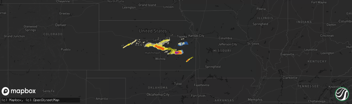
Hail Map on April 26, 2026
The weather event on April 26, 2026 includes Hail, Wind, and Tornado maps. 14 states and 766 cities were impacted and suffered possible damage. The total estimated number of properties impacted is 564,241.
Hail
Wind
Tornado
564,241
Estimated number of impacted properties by a 1.00" hail or larger157,400
Estimated number of impacted properties by a 1.75" hail or larger59,334
Estimated number of impacted properties by a 2.50" hail or largerStates Impacted by Hail Map on April 26, 2026
Storm reports
Oklahoma
| Date | Description |
|---|---|
| 04/26/20266:46 PM CDT | Report from mping: quarter |
| 04/26/20266:26 PM CDT | A local report indicates 2.75 inch wind near 6 NW Central High |
| 04/26/20266:16 PM CDT | A local report indicates 2.75 inch wind near 6 ENE Lawton |
| 04/26/20266:14 PM CDT | Report from mping: quarter |
| 04/26/20266:13 PM CDT | A local report indicates 1.75 inch wind near 6 N Hulen |
| 04/26/20266:02 PM CDT | Report from mping: quarter |
| 04/26/20265:53 PM CDT | A local report indicates 1.00 inch wind near 6 WNW Walters |
| 04/25/20268:00 PM CDT | Power lines down south of foraker. |
| 04/25/20267:55 PM CDT | Spotter video of tornado approximately 2 miles south of foraker. |
| 04/25/20267:30 PM CDT | A local report indicates 1.00 inch wind near 2 S Foraker |
Louisiana
| Date | Description |
|---|---|
| 04/26/20268:30 AM CDT | A large tree fell across la-highway 169 near the intersection of la-highway 538... Downing powerlines and blocking traffic. |
| 04/26/20268:28 AM CDT | Hail size of at least half dollar size was reported in the town of mooringsport. |
Illinois
| Date | Description |
|---|---|
| 04/26/20265:51 AM CDT | A local report indicates 1.75 inch wind near Dowell |
| 04/26/20265:41 AM CDT | Pea to quarter sized hail. Time estimate from radar. |
| 04/26/20265:41 AM CDT | A local report indicates 1.25 inch wind near Vergennes |
| 04/26/20265:39 AM CDT | A local report indicates 1.75 inch wind near Vergennes |
Missouri
| Date | Description |
|---|---|
| 04/26/20266:58 PM CDT | Damage to a brick building in collins. |
| 04/26/20266:58 PM CDT | A local report indicates 1.00 inch wind near Golden City |
| 04/26/20266:40 PM CDT | A local report indicates 2.75 inch wind near 3 ENE Caplinger Mills |
| 04/26/20266:30 PM CDT | Tree downed onto a shed in clinton... Mo. Report relayed via social media. Time estimated from radar. |
| 04/26/20266:29 PM CDT | Trees down near sparrowfoot campground. Report relayed via social media. Time estimated from radar. |
| 04/26/20266:28 PM CDT | Report relayed from social media. Time estimated from radar. |
| 04/26/20266:22 PM CDT | Report from mping - quarter |
| 04/26/20266:20 PM CDT | Report from mping ping pong ball |
| 04/26/20266:20 PM CDT | A local report indicates 2.75 inch wind near 1 SSW El Dorado Springs |
| 04/26/20266:20 PM CDT | A local report indicates 2.00 inch wind near 1 S El Dorado Springs |
| 04/26/20266:18 PM CDT | Reported at a hospital. |
| 04/26/20266:14 PM CDT | Several reports of downed wires and power outages near routes n and o. Time estimated from radar. |
| 04/26/20266:14 PM CDT | West of el dorado springs. |
| 04/26/20266:14 PM CDT | Image of baseball sized hail 2 miles southeast of el dorado springs. Time estimated via radar. |
| 04/26/20266:12 PM CDT | Report from mping half dollar |
| 04/26/20266:03 PM CDT | Windshield shattered due to tennis ball size hail. |
| 04/26/20266:00 PM CDT | Tree limbs down between creighton and urich. Report relayed via social media. Time estimated from radar. |
| 04/26/20265:54 PM CDT | Downed wires and power outages near route zz. Time estimated from radar. |
| 04/26/20265:50 PM CDT | Social media report. Large tree downed onto property in butler. Time estimated from radar. |
| 04/26/20265:50 PM CDT | Several rvs with roof damage from hail. |
| 04/26/20265:50 PM CDT | A local report indicates 1.75 inch wind near 1 WNW Nevada |
| 04/26/20265:50 PM CDT | Report from mping ping pong ball |
| 04/26/20265:49 PM CDT | Report from mping. Hen egg |
| 04/26/20265:40 PM CDT | A local report indicates 1.50 inch wind near Metz |
| 04/26/20265:27 PM CDT | Report of tree and power line down in adrian. Time estimated from radar. |
| 04/26/20265:27 PM CDT | Large tree down near second street. Social media report and video. Time confirmed from radar. |
| 04/26/20265:26 PM CDT | Several reports of downed power poles or downed wires near the peculiar area. Time estimated from radar. |
| 04/26/20265:07 PM CDT | Time estimated from radar. |
| 04/26/20265:07 PM CDT | Private weather sensor. |
| 04/26/20266:59 AM CDT | Report from mping: ping pong ball |
| 04/26/20266:59 AM CDT | Multiple power poles down. |
| 04/26/20266:54 AM CDT | Report from mping: quarter |
| 04/26/20266:50 AM CDT | Multiple 6-10 inch limbs down and dime size hail. |
| 04/26/20266:50 AM CDT | Tree across roadway. |
| 04/26/20266:46 AM CDT | Quarter size hail report four blocks east of the university. |
| 04/26/20266:46 AM CDT | Report from mping: half dollar |
| 04/26/20266:42 AM CDT | Report from mping: half dollar |
| 04/26/20266:21 AM CDT | Report from mping: quarter |
| 04/26/20266:20 AM CDT | A local report indicates 1.00 inch wind near 2 ENE Maplewood |
| 04/26/20266:19 AM CDT | Report from mping: quarter |
| 04/26/20266:18 AM CDT | Large tree snapped causing damage to roof. |
| 04/26/20266:16 AM CDT | Estimated ping pong sized hail with photo and us quarter. Time estimated from radar. |
| 04/26/20266:16 AM CDT | Report from mping: quarter |
| 04/26/20266:15 AM CDT | A local report indicates 1.75 inch wind near 1 E University City |
| 04/26/20266:15 AM CDT | Picture received on x from near kings highway and mlk dr. |
| 04/26/20266:15 AM CDT | Picture received on x. |
| 04/26/20266:15 AM CDT | A local report indicates 1.50 inch wind near 1 N University City |
| 04/26/20266:13 AM CDT | Trees uprooted. Report relayed via social media. Time estimated from radar. |
| 04/26/20266:10 AM CDT | Trees down... Damaging deck railing. Report relayed via social media. Corrected time estimated from radar. |
| 04/26/20265:28 AM CDT | A local report indicates 1.00 inch wind near 2 W Williamsville |
| 04/26/20265:10 AM CDT | Trees down... Damaging deck railing. Report relayed via social media. Time estimated from radar. |
| 04/26/20264:40 AM CDT | Upper portion of oak tree broken off. Report relayed via social media. Time estimated from radar. |
| 04/26/20264:33 AM CDT | Private weather sensor. |
| 04/26/20264:23 AM CDT | Trees down on route 13 south of kingston. Time estimated from radar. |
| 04/26/20264:20 AM CDT | Carport flipped. Report relayed via social media. Time estimated from radar. |
| 04/26/20264:18 AM CDT | Report from mping: hen egg |
| 04/26/20264:13 AM CDT | Shingles blown off house and minor property damage. Time and location estimated. |
| 04/26/20264:10 AM CDT | Trees across u.s. 69 south of highway 121. Time estimated from radar. |
| 04/26/20264:09 AM CDT | Semi blown over. Tree blown down. Time estimated from radar. |
| 04/26/20263:58 AM CDT | Report from mping: ping pong ball |
| 04/26/20263:54 AM CDT | Tree uprooted. Report relayed via social media. Time estimated from radar. |
| 04/26/20263:54 AM CDT | Time estimated from radar. |
| 04/26/20263:50 AM CDT | Report from mping: half dollar |
| 04/26/20263:44 AM CDT | Report from mping: ping pong ball |
| 04/26/20263:43 AM CDT | Tree partially snapped. Report relayed via social media. Time estimated from radar. |
| 04/26/20263:42 AM CDT | Small grill with full propane tank lifted and thrown. Report relayed via social media. Time estimated from radar. |
| 04/26/20263:41 AM CDT | Report from mping: quarter |
| 04/26/20263:39 AM CDT | Report from mping: golf ball |
| 04/26/20263:37 AM CDT | A local report indicates 1.25 inch wind near 1 NW Farmington |
| 04/26/20263:36 AM CDT | A local report indicates 1.75 inch wind near 3 SE Farmington |
| 04/26/20263:33 AM CDT | Time estimated from radar. |
| 04/26/20263:33 AM CDT | Time estimated from radar. |
| 04/26/20263:33 AM CDT | Photo of multiple large hail stones... Largest is measured at 2 inches. Time estimated from radar. |
| 04/26/20263:33 AM CDT | Time estimated from radar. |
| 04/26/20263:33 AM CDT | Time estimated from radar. |
| 04/26/20263:33 AM CDT | Report from mping: golf ball |
| 04/26/20263:30 AM CDT | Picture received on x. |
| 04/26/20263:29 AM CDT | Report from mping: quarter |
| 04/26/20263:29 AM CDT | Report from mping: quarter |
| 04/26/20263:20 AM CDT | A local report indicates 2.50 inch wind near 2 NE Doe Run |
| 04/26/20263:20 AM CDT | Report from mping: hen egg |
| 04/26/20263:18 AM CDT | Report from mping: golf ball |
| 04/26/20263:13 AM CDT | Report from mping: ping pong ball |
| 04/26/20263:08 AM CDT | A local report indicates 1.25 inch wind near Irondale |
| 04/26/20263:07 AM CDT | Time estimated from radar. |
| 04/26/20263:00 AM CDT | A local report indicates 1.00 inch wind near 3 SE Northwye |
| 04/26/20262:58 AM CDT | A local report indicates 1.00 inch wind near 1 SE Rolla |
| 04/26/20262:57 AM CDT | A local report indicates 1.75 inch wind near Caledonia |
| 04/26/20262:56 AM CDT | A local report indicates 1.25 inch wind near 1 WSW Rolla |
| 04/25/202611:08 PM CDT | Tree was downed. |
| 04/25/202610:39 PM CDT | Social media report and photo. |
| 04/25/202610:35 PM CDT | Social media report. Time estimated from radar. |
| 04/25/202610:26 PM CDT | Image received of golf ball sized hail just south of the lebanon airport. Time estimated via radar. |
| 04/25/202610:25 PM CDT | Social media video. Time estimated from radar. |
| 04/25/202610:25 PM CDT | A local report indicates 1.25 inch wind near 3 S Lebanon |
| 04/25/202610:22 PM CDT | Social media report. Time estimated from radar. |
| 04/25/202610:21 PM CDT | Image received of 2 inch hail. Time estimated via radar. |
| 04/25/202610:08 PM CDT | Image received of 3 inch hail. Time estimated via radar. |
| 04/25/20269:52 PM CDT | Several reports of downed wires and power outages in the archie area. Time estimated from radar. |
| 04/25/20268:17 PM CDT | A local report indicates 1.75 inch wind near Morrisville |
| 04/25/20268:07 PM CDT | A local report indicates 1.75 inch wind near Walnut Grove |
| 04/25/20267:43 PM CDT | A local report indicates 1.75 inch wind near 3 SSE Neola |
| 04/25/20267:42 PM CDT | A local report indicates 1.75 inch wind near 1 S Arcola |
| 04/25/20267:35 PM CDT | Report from mping - hen egg |
| 04/25/20267:32 PM CDT | Dade county line on stockton lake. |
| 04/25/20267:25 PM CDT | A local report indicates 1.50 inch wind near 4 ENE Elkton |
| 04/25/20267:21 PM CDT | Near greenfield. |
| 04/25/20267:17 PM CDT | Social media report. Time estimated from radar. |
| 04/25/20267:03 PM CDT | A local report indicates 1.00 inch wind near 2 WSW Flemington |
| 04/25/20267:01 PM CDT | A local report indicates 2.75 inch wind near Humansville |
| 04/25/20267:01 PM CDT | A local report indicates 2.00 inch wind near Humansville |
| 04/25/20267:01 PM CDT | A local report indicates 1.50 inch wind near Humansville |
Mississippi
| Date | Description |
|---|---|
| 04/26/20266:15 PM CDT | A local report indicates 1.00 inch wind near 1 E Okahola |
| 04/26/20266:07 PM CDT | Social media pictures from along old hwy 11. |
| 04/26/20266:05 PM CDT | Social media reports from between purvis and oak grove. |
| 04/26/20265:59 PM CDT | Fell along burnt bridge rd. |
| 04/26/20267:12 AM CDT | Scattered trees were reported down by the lincoln county em. |
| 04/26/20267:08 AM CDT | Tree down on a mobile home. |
| 04/26/20267:00 AM CDT | Scattered trees were reported down by the lincoln county em. |
Texas
| Date | Description |
|---|---|
| 04/26/20266:08 PM CDT | Report from mping: quarter |
| 04/26/20266:00 PM CDT | Photo of large hail on the south side of burkburnett. |
| 04/26/20265:46 PM CDT | Report from mping: quarter |
| 04/26/20265:46 PM CDT | A local report indicates 1.75 inch wind near 1 W Sheppard Afb |
| 04/26/20265:35 PM CDT | Report from mping: quarter |
| 04/26/20265:19 PM CDT | A local report indicates 3.00 inch wind near 2 NNW Iowa Park |
| 04/26/20265:11 PM CDT | A local report indicates 1.75 inch wind near 2 NNW Iowa Park |
| 04/26/20265:11 PM CDT | A local report indicates 1.50 inch wind near 1 WNW Iowa Park |
| 04/26/20265:08 PM CDT | A local report indicates 1.00 inch wind near 2 NNW Iowa Park |
| 04/25/20267:52 PM CDT | Report from mping: quarter |
| 04/25/20267:15 PM CDT | Report from mping: golf ball |
| 04/25/20267:11 PM CDT | Report from mping: hen egg+ |
Colorado
| Date | Description |
|---|---|
| 04/25/20268:27 PM CDT | Hail ranging from pea to 1.5 inches due south of bethune between county roads n and p on cr 40. |
| 04/25/20267:55 PM CDT | Spotter network report of hail up to quarter in size. |
Kansas
| Date | Description |
|---|---|
| 04/26/20266:47 PM CDT | Report of brief tornado touchdown. |
| 04/26/20265:15 PM CDT | Downed wires and power outages near watties road. Time estimated from radar. |
| 04/26/20265:03 PM CDT | Downed wires near belleview road. Time estimated from radar. |
| 04/26/20264:59 PM CDT | Downed wires and power outages near delmont drive. Time estimated from radar. |
| 04/26/20264:56 PM CDT | Corrects previous tstm wnd dmg report from bucyrus. Downed trees and blown down fence at a residence near bucyrus. Time estimated from radar. |
| 04/26/20264:40 PM CDT | Report via personal weather station. |
| 04/26/20264:38 PM CDT | Private weather sensor. |
| 04/26/20264:29 PM CDT | Several downed trees southwest of hillsdale lake. Time estimated from radar. |
| 04/26/20264:20 PM CDT | Homes damaged and barn destroyed. Time estimated from radar. |
| 04/26/20264:18 PM CDT | Quarter hail broke one glass window. |
| 04/26/20264:13 PM CDT | A local report indicates 1.00 inch wind near 4 NW Iola |
| 04/26/20264:12 PM CDT | Social media picture of quarter size hail in fort scott... Kansas. |
| 04/26/20264:07 PM CDT | 0.5 inch hail. |
| 04/26/20264:03 PM CDT | 80+ mph winds estimated with quarter sized hail reported 9 ne of yates center. |
| 04/26/20263:52 PM CDT | A local report indicates 1.50 inch wind near 4 SW Le Roy |
| 04/26/20263:52 PM CDT | A local report indicates 1.00 inch wind near 9 N Yates Center |
| 04/26/20263:52 PM CDT | A local report indicates 1.50 inch wind near 1 W Gridley |
| 04/26/20263:49 PM CDT | Estimated 65 mph with pea sized hail. |
| 04/26/20263:48 PM CDT | A local report indicates 1.00 inch wind near 6 W Le Roy |
| 04/26/20263:45 PM CDT | A local report indicates 60 MPH wind near 9 N Yates Center |
| 04/26/20263:34 PM CDT | A local report indicates 60 MPH wind near Lyndon |
| 04/26/20263:29 PM CDT | A local report indicates 1.25 inch wind near Gridley |
| 04/26/20263:17 PM CDT | Public report of hail between 1.5 and 2 inches in diameter or just slightly smaller than a golf ball. |
| 04/26/20263:08 PM CDT | A local report indicates 2.00 inch wind near Madison |
| 04/26/20263:03 PM CDT | A local report indicates 1.00 inch wind near 3 NW Madison |
| 04/26/20263:03 PM CDT | Measured with hand held anemometer. |
| 04/26/20262:37 PM CDT | Delayed report from mping. |
| 04/26/20262:34 PM CDT | A local report indicates 1.00 inch wind near 2 SE Cassoday |
| 04/26/20262:15 PM CDT | Delayed report from mping. |
| 04/26/20261:32 PM CDT | A local report indicates 1.00 inch wind near Florence |
| 04/26/20261:23 PM CDT | Picture of 1 1/4 inch hail. |
| 04/26/20261:13 PM CDT | Delayed report of 1 inch hail. |
| 04/26/20261:13 PM CDT | A local report indicates 1.00 inch wind near Hillsboro |
| 04/26/20261:08 PM CDT | A local report indicates 1.00 inch wind near 4 W White City |
| 04/26/20261:06 PM CDT | Delayed report from mping: ping pong ball |
| 04/26/202612:57 PM CDT | Report of tree through roof at house in lehigh. |
| 04/26/202612:55 PM CDT | A local report indicates 1.75 inch wind near Hillsboro |
| 04/26/202612:52 PM CDT | Piles of quarter size hail. |
| 04/26/202612:50 PM CDT | A local report indicates 1.00 inch wind near 6 NNW Hope |
| 04/26/202612:45 PM CDT | Quarter size according to fire chief. |
| 04/26/202612:32 PM CDT | Half dollar hail size piling up. |
| 04/26/202612:32 PM CDT | A local report indicates 70 MPH wind near Canton |
| 04/26/202612:30 PM CDT | Time estimated from radar. |
| 04/26/202612:29 PM CDT | A local report indicates 1.00 inch wind near Carlton |
| 04/26/202612:18 PM CDT | Delayed report from mping. |
| 04/26/202612:08 PM CDT | A local report indicates 1.00 inch wind near 1 NE Mcpherson |
| 04/26/202612:05 PM CDT | A local report indicates 1.75 inch wind near 7 NNE Mcpherson |
| 04/26/202611:06 AM CDT | A local report indicates 1.00 inch wind near Geneseo |
| 04/26/20269:55 AM CDT | Damaged and broken power poles reported in columbus... Ks. |
| 04/26/20266:05 AM CDT | A local report indicates 1.00 inch wind near 1 NW Stanley |
| 04/26/20266:00 AM CDT | Report from mping: half dollar |
| 04/26/20265:56 AM CDT | Report from mping: half dollar |
| 04/26/20265:50 AM CDT | Report from mping: quarter |
| 04/26/20265:48 AM CDT | A local report indicates 1.00 inch wind near 1 SE Olathe |
| 04/26/20265:47 AM CDT | Report relayed from social media. Time estimated from radar. |
| 04/26/20265:46 AM CDT | Report from mping: half dollar |
| 04/26/20265:46 AM CDT | Spotter called in... Reported hail between 3/4 and 1 3/4 between 5:42-5:46am... Time confirmed from radar. |
| 04/26/20265:43 AM CDT | Report from mping: quarter |
| 04/26/20265:42 AM CDT | Report from mping: quarter |
| 04/26/20265:41 AM CDT | Report from mping: quarter |
| 04/26/20265:33 AM CDT | Report from mping: half dollar |
| 04/26/20265:32 AM CDT | Report from mping: quarter |
| 04/26/20265:14 AM CDT | 6 inch tree limb blocking tennessee street. Time estimated from radar. |
| 04/26/20265:12 AM CDT | Delayed report. A few 6-8 inch tree branches down in the area. Time estimated from radar. |
| 04/26/20265:11 AM CDT | Delayed report. Mping report of half dollar size hail. |
| 04/26/20265:05 AM CDT | Delayed report. |
| 04/26/20263:58 AM CDT | A local report indicates 1.00 inch wind near 1 NNW Maywood |
| 04/26/20263:58 AM CDT | A local report indicates 69 MPH wind near 1 NNW Maywood |
| 04/26/20263:56 AM CDT | A local report indicates 1.00 inch wind near 2 ENE Tonganoxie |
| 04/26/20263:55 AM CDT | Report from mping: quarter |
| 04/26/20263:51 AM CDT | Power lines downed. |
| 04/26/20263:50 AM CDT | Private weather sensor. |
| 04/26/20263:49 AM CDT | Private weather sensor. |
| 04/26/20263:43 AM CDT | A local report indicates 70 MPH wind near Tonganoxie |
| 04/26/20263:40 AM CDT | Report from mping: quarter |
| 04/26/20263:38 AM CDT | A local report indicates 1.00 inch wind near 2 N Tonganoxie |
| 04/26/20263:31 AM CDT | Personal weather station. |
| 04/26/20263:15 AM CDT | Large tree branches snapped. Report relayed via social media. Time estimated from radar. |
| 04/26/20262:58 AM CDT | Report from mping: quarter |
| 04/26/20262:57 AM CDT | Report from mping: quarter |
| 04/26/20262:57 AM CDT | A local report indicates 1.00 inch wind near 7 SSE Silver Lake |
| 04/26/20262:54 AM CDT | At the nws office. |
| 04/26/20262:53 AM CDT | Report from mping: quarter |
| 04/26/20262:52 AM CDT | A local report indicates 70 MPH wind near 3 N Topeka |
| 04/26/20262:50 AM CDT | A local report indicates 1.50 inch wind near 3 WNW Topeka |
| 04/26/20262:50 AM CDT | Personal weather station. |
| 04/26/20262:50 AM CDT | A local report indicates 1.75 inch wind near 4 NW Topeka |
| 04/26/20262:49 AM CDT | Report from mping: quarter |
| 04/26/20262:48 AM CDT | Personal weather station. |
| 04/26/20262:48 AM CDT | A local report indicates 1.00 inch wind near 3 NNW Pauline |
| 04/26/20262:45 AM CDT | Also estimating 50 mph winds with the hail. |
| 04/26/20262:42 AM CDT | Ktop asos. |
| 04/26/20262:40 AM CDT | A local report indicates 1.00 inch wind near 7 SSE Silver Lake |
| 04/26/20262:30 AM CDT | Personal weather station. |
| 04/26/20262:20 AM CDT | Lawn furniture is being blown around and things knocking into the house. |
| 04/26/20261:58 AM CDT | Off-duty nws employee. |
| 04/26/20261:37 AM CDT | A local report indicates 1.00 inch wind near Alta Vista |
| 04/26/20261:29 AM CDT | A local report indicates 1.00 inch wind near 6 N Sylvan Grove |
| 04/26/20261:28 AM CDT | A local report indicates 1.00 inch wind near 2 WSW Junction City |
| 04/26/20261:15 AM CDT | A local report indicates 1.50 inch wind near Lucas |
| 04/26/20261:03 AM CDT | A local report indicates 1.25 inch wind near 1 NW Arkansas City |
| 04/26/20261:03 AM CDT | A local report indicates 1.50 inch wind near Arkansas City |
| 04/26/20261:02 AM CDT | A local report indicates 1.50 inch wind near Arkansas City |
| 04/26/20261:02 AM CDT | Report from mping: quarter |
| 04/26/20261:01 AM CDT | A local report indicates 1.25 inch wind near 1 NW Arkansas City |
| 04/26/202612:54 AM CDT | Report from mping: quarter |
| 04/26/202612:48 AM CDT | A local report indicates 1.00 inch wind near 8 N Russell |
| 04/26/202612:46 AM CDT | A local report indicates 1.00 inch wind near Solomon |
| 04/26/202612:41 AM CDT | Report from mping: hen egg |
| 04/26/202612:37 AM CDT | Report from mping: hen egg |
| 04/26/202612:34 AM CDT | Report from mping: half dollar |
| 04/26/202612:32 AM CDT | Report from mping: quarter |
| 04/26/202612:31 AM CDT | Report from mping: hen egg |
| 04/26/202612:30 AM CDT | Report from mping: quarter |
| 04/26/202612:29 AM CDT | A local report indicates 1.50 inch wind near 2 S Salina |
| 04/26/202612:28 AM CDT | A local report indicates 2.00 inch wind near 6 SW Salina |
| 04/26/202612:27 AM CDT | A local report indicates 2.00 inch wind near 2 SSW Salina |
| 04/26/202612:27 AM CDT | A local report indicates 1.50 inch wind near 1 NNE Salina |
| 04/26/202612:23 AM CDT | A local report indicates 1.25 inch wind near 2 SW Smolan |
| 04/26/202612:10 AM CDT | Also estimated wind gusts of 45 to 55 mph. |
| 04/26/202612:08 AM CDT | A local report indicates 1.00 inch wind near 10 NW Marquette |
| 04/26/202612:00 AM CDT | A local report indicates 2.00 inch wind near 2 SE Salina |
| 04/25/202611:50 PM CDT | A local report indicates 1.00 inch wind near 8 NE Ellsworth |
| 04/25/202611:46 PM CDT | A local report indicates 1.50 inch wind near Ellsworth |
| 04/25/202611:39 PM CDT | A local report indicates 1.00 inch wind near 3 ESE Lindsborg |
| 04/25/202611:35 PM CDT | Report from mping: quarter |
| 04/25/202611:35 PM CDT | A local report indicates 1.75 inch wind near 5 N Mcpherson |
| 04/25/202611:35 PM CDT | A local report indicates 1.00 inch wind near 5 S Lindsborg |
| 04/25/202611:35 PM CDT | A local report indicates 1.00 inch wind near 6 S Lindsborg |
| 04/25/202610:21 PM CDT | Downed trees and blown down fence at a residence near bucyrus. Time estimated from radar. |
| 04/25/20269:49 PM CDT | Multiple trees downed including tress on houses. |
| 04/25/20269:28 PM CDT | Several tree limbs down along with power poles and power lines. |
| 04/25/20268:32 PM CDT | Report of tornado on the ground. |
| 04/25/20268:26 PM CDT | A local report indicates 1.00 inch wind near Longton |
| 04/25/20267:55 PM CDT | A couple brief rope tornado touchdowns between 7:45pm and 8pm. Location estimated from radar. |
| 04/25/20267:31 PM CDT | Report from mping: baseball |
| 04/25/20267:31 PM CDT | A local report indicates 3.00 inch wind near 1 NW Cherryvale |
| 04/25/20267:17 PM CDT | A local report indicates 2.50 inch wind near Sycamore |
| 04/25/20267:15 PM CDT | A local report indicates 2.50 inch wind near Sycamore |
| 04/25/20267:13 PM CDT | Time estimated from radar. |
| 04/25/20267:02 PM CDT | Tornado confirmed by spotter. |
Cities Impacted by Hail Map on April 26, 2026
- Leonard, TX
- Celeste, TX
- Bailey, TX
- Wolfe City, TX
- Trenton, TX
- Ness City, KS
- Jefferson, TX
- Beeler, KS
- Liberty, MS
- Summit, MS
- Smithdale, MS
- Bonham, TX
- Soso, MS
- Taylorsville, MS
- Vivian, LA
- Karnack, TX
- Bazine, KS
- Brownell, KS
- Mooringsport, LA
- Franklinton, LA
- Amite, LA
- Kentwood, LA
- Mount Hermon, LA
- Ransom, KS
- Waynesboro, MS
- Laurel, MS
- Oil City, LA
- Shreveport, LA
- McCracken, KS
- Loranger, LA
- Folsom, LA
- Buckatunna, MS
- Millry, AL
- Hays, KS
- Schoenchen, KS
- Russell, KS
- Victoria, KS
- La Crosse, KS
- New Orleans, LA
- Bison, KS
- Otis, KS
- Violet, LA
- Hoisington, KS
- Bunker Hill, KS
- Dorrance, KS
- Claflin, KS
- Gorham, KS
- Ellinwood, KS
- Bushton, KS
- Geneseo, KS
- Lyons, KS
- Lorraine, KS
- Ellsworth, KS
- Wilson, KS
- Chase, KS
- Holyrood, KS
- Little River, KS
- Kanopolis, KS
- Marquette, KS
- Lindsborg, KS
- Mcpherson, KS
- Windom, KS
- Gypsum, KS
- Galva, KS
- Canton, KS
- Roxbury, KS
- Assaria, KS
- Durham, KS
- Lehigh, KS
- Tampa, KS
- Hillsboro, KS
- Hope, KS
- New Cambria, KS
- Abilene, KS
- Newton, KS
- Herington, KS
- Woodbine, KS
- Chapman, KS
- Enterprise, KS
- Walton, KS
- Peabody, KS
- Marion, KS
- White City, KS
- Lincolnville, KS
- Florence, KS
- Junction City, KS
- Ramona, KS
- Lost Springs, KS
- Dwight, KS
- Council Grove, KS
- Wilsey, KS
- Cedar Point, KS
- Elmdale, KS
- Bivins, TX
- Rodessa, LA
- Ida, LA
- Burns, KS
- Cottonwood Falls, KS
- Matfield Green, KS
- El Dorado, KS
- Cassoday, KS
- Olpe, KS
- Eureka, KS
- Salina, KS
- Solomon, KS
- Hamilton, KS
- Madison, KS
- Reading, KS
- Osage City, KS
- Lebo, KS
- Lyndon, KS
- Virgil, KS
- Gridley, KS
- Galesburg, KS
- Erie, KS
- Saint Paul, KS
- Burlington, KS
- Melvern, KS
- Quenemo, KS
- Vassar, KS
- Hartford, KS
- Manhattan, KS
- Carbondale, KS
- Wakarusa, KS
- Wamego, KS
- Pomona, KS
- Stark, KS
- Walnut, KS
- Uniontown, KS
- Yates Center, KS
- Le Roy, KS
- Scranton, KS
- Berryton, KS
- Overbrook, KS
- Ottawa, KS
- Williamsburg, KS
- Hepler, KS
- Fort Scott, KS
- Neosho Falls, KS
- Baldwin City, KS
- Wellsville, KS
- Redfield, KS
- Colony, KS
- Iola, KS
- Piqua, KS
- Westphalia, KS
- Garnett, KS
- Welda, KS
- Rantoul, KS
- Paola, KS
- Fort Lauderdale, FL
- Moran, KS
- La Harpe, KS
- Kincaid, KS
- Edgerton, KS
- Richmond, KS
- Princeton, KS
- Alma, KS
- Spring Hill, KS
- Parker, KS
- Centerville, KS
- Bronson, KS
- Blue Mound, KS
- Bucyrus, KS
- Louisburg, KS
- Iowa Park, TX
- Electra, TX
- Osawatomie, KS
- Mound City, KS
- La Cygne, KS
- Fontana, KS
- Greeley, KS
- Cleveland, MO
- Mapleton, KS
- Wichita Falls, TX
- Pleasanton, KS
- Fulton, KS
- Burkburnett, TX
- Grenola, KS
- Moline, KS
- Drexel, MO
- Freeman, MO
- Amoret, MO
- Columbia, MS
- Foster, MO
- Prescott, KS
- Amsterdam, MO
- Richards, MO
- Deerfield, MO
- Nevada, MO
- Moundville, MO
- Sheppard Afb, TX
- Hume, MO
- Elk Falls, KS
- Peculiar, MO
- Columbus, KS
- Galena, KS
- Sumrall, MS
- Butler, MO
- Carl Junction, MO
- Pittsburg, KS
- Weir, KS
- Lawton, OK
- Geronimo, OK
- Walters, OK
- Asbury, MO
- Purvis, MS
- Garden City, MO
- Creighton, MO
- Devol, OK
- Walker, MO
- Rich Hill, MO
- Randlett, OK
- Lumberton, MS
- El Dorado Springs, MO
- Harwood, MO
- Milo, MO
- Stockton, MO
- Webb City, MO
- Oronogo, MO
- Jasper, MO
- Rockville, MO
- Blairstown, MO
- Holden, MO
- Chilhowee, MO
- Appleton City, MO
- Longton, KS
- Hattiesburg, MS
- Grandfield, OK
- Purcell, MO
- Neck City, MO
- Duncan, OK
- Marlow, OK
- Elgin, OK
- Fletcher, OK
- Schell City, MO
- Osceola, MO
- Rush Springs, OK
- Fredonia, KS
- Elk City, KS
- Carthage, MO
- Alba, MO
- Leeton, MO
- Centerview, MO
- Ninnekah, OK
- Cement, OK
- Petrolia, TX
- Byers, TX
- Humansville, MO
- Collins, MO
- Golden City, MO
- Neodesha, KS
- Clinton, MO
- Lamar, MO
- Flemington, MO
- Weaubleau, MO
- Wheatland, MO
- Bolivar, MO
- Lockwood, MO
- Independence, KS
- Calhoun, MO
- Hortense, GA
- Warsaw, MO
- Shidler, OK
- Kaw City, OK
- Cherryvale, KS
- South Greenfield, MO
- Greenfield, MO
- Waynesville, GA
- Pittsburg, MO
- Polk, MO
- Hermitage, MO
- Arcola, MO
- Dadeville, MO
- Flagler, CO
- Everton, MO
- Deepwater, MO
- Dennis, KS
- Aldrich, MO
- Fair Play, MO
- Walnut Grove, MO
- Mound Valley, KS
- Parsons, KS
- Vona, CO
- Ash Grove, MO
- Half Way, MO
- Urbana, MO
- Preston, MO
- Morrisville, MO
- Kit Carson, CO
- Windsor, MO
- Stratton, CO
- Thayer, KS
- Pawhuska, OK
- Henrietta, TX
- Ryan, OK
- Altamont, KS
- Brighton, MO
- Pleasant Hope, MO
- Cross Timbers, MO
- Macks Creek, MO
- Climax Springs, MO
- Willard, MO
- Altoona, KS
- Bethune, CO
- Oswego, KS
- Burlington, CO
- Buffalo, MO
- Roach, MO
- Quincy, MO
- Lane, KS
- McCune, KS
- Elkland, MO
- Bartlesville, OK
- West Mineral, KS
- Scammon, KS
- Cherokee, KS
- Long Lane, MO
- Chetopa, KS
- Adrian, MO
- Louisburg, MO
- Tunas, MO
- Windyville, MO
- Archie, MO
- Baxter Springs, KS
- Phillipsburg, MO
- Harrisonville, MO
- Lowry City, MO
- Jetmore, KS
- Lebanon, MO
- Conway, MO
- Riverton, KS
- Joplin, MO
- Utica, KS
- Urich, MO
- Carterville, MO
- Duenweg, MO
- Diamond, MO
- Eldridge, MO
- Olmitz, KS
- Stoutland, MO
- Richland, MO
- Edwards, MO
- Pleasant Hill, MO
- Fairview, OK
- Cleo Springs, OK
- Montrose, MO
- Kingsville, MO
- Sarcoxie, MO
- Neosho, MO
- Granby, MO
- Camdenton, MO
- Helena, OK
- Reeds, MO
- Pierce City, MO
- Ellis, KS
- Fort Leonard Wood, MO
- Saint Robert, MO
- Waynesville, MO
- Wentworth, MO
- Burdick, KS
- Brookville, KS
- Wakeeney, KS
- Collyer, KS
- Stark City, MO
- Laquey, MO
- Green, KS
- Clay Center, KS
- Verona, MO
- Monett, MO
- Alta Vista, KS
- Strong City, KS
- Falun, KS
- Montreal, MO
- Corning, KS
- Walker, KS
- Paxico, KS
- Randolph, KS
- Seneca, KS
- Duke, MO
- Newburg, MO
- Catharine, KS
- Gilliam, MO
- Slater, MO
- Devils Elbow, MO
- Dixon, MO
- Crocker, MO
- Lincoln, KS
- Glasgow, MO
- Sylvan Grove, KS
- Beverly, KS
- Tescott, KS
- Topeka, KS
- Aurora, MO
- Crane, MO
- Armstrong, MO
- Rolla, MO
- Paradise, KS
- McFarland, KS
- Oneida, KS
- Quinter, KS
- Braman, OK
- Edgar Springs, MO
- Allen, KS
- Marionville, MO
- Galena, MO
- Higbee, MO
- Westmoreland, KS
- Onaga, KS
- Frankfort, KS
- Waldo, KS
- Geuda Springs, KS
- Newkirk, OK
- Bennington, KS
- Saint Marys, KS
- Rossville, KS
- Maple Hill, KS
- Eskridge, KS
- Minneapolis, KS
- Morland, KS
- Saint James, MO
- Cook Sta, MO
- Vermillion, KS
- Lucas, KS
- Luray, KS
- Arkansas City, KS
- Belvue, KS
- Falls City, NE
- Verdon, NE
- Shubert, NE
- Centralia, KS
- Jerome, MO
- Salem, MO
- Delia, KS
- Mayetta, KS
- Steelville, MO
- Kingman, KS
- Rock Port, MO
- Clark, MO
- Winfield, KS
- Hudson, KS
- Goff, KS
- Haven, KS
- Pretty Prairie, KS
- Hunter, KS
- Havensville, KS
- Barnard, KS
- Riley, KS
- Tarkio, MO
- Nortonville, KS
- Winchester, KS
- Fairfax, MO
- Linn Creek, MO
- Clearmont, MO
- Harveyville, KS
- Beloit, KS
- Elmo, MO
- Braddyville, IA
- Wakefield, KS
- Talmage, KS
- Milford, KS
- Cherryville, MO
- Delphos, KS
- Glasco, KS
- Davisville, MO
- Burrton, KS
- Fort Riley, KS
- Bogue, KS
- Ogden, KS
- Bourbon, MO
- Silver Lake, KS
- Potosi, MO
- McLouth, KS
- Loose Creek, MO
- Belgrade, MO
- Tecumseh, KS
- Grantville, KS
- Lecompton, KS
- Meriden, KS
- Perry, KS
- Hoyt, KS
- Atchison, KS
- Cummings, KS
- Linn, MO
- Lawrence, KS
- Caledonia, MO
- Irondale, MO
- Bonne Terre, MO
- Park Hills, MO
- Mineral Point, MO
- Leadwood, MO
- Bismarck, MO
- Rushville, MO
- Weston, MO
- Chamois, MO
- Ozawkie, KS
- Farlington, KS
- Valley Falls, KS
- Easton, KS
- Oskaloosa, KS
- Leavenworth, KS
- Fort Leavenworth, KS
- Platte City, MO
- Auburn, KS
- Tonganoxie, KS
- Hermann, MO
- Morrison, MO
- Farmington, MO
- Ironton, MO
- Doe Run, MO
- Mount Sterling, MO
- De Kalb, MO
- Dearborn, MO
- Camden Point, MO
- Gerald, MO
- Cuba, MO
- Basehor, KS
- Gower, MO
- Faucett, MO
- Linwood, KS
- Bloomsdale, MO
- Sainte Genevieve, MO
- French Village, MO
- Edgerton, MO
- Agency, MO
- Trimble, MO
- Berger, MO
- Smithville, MO
- Plattsburg, MO
- Bonner Springs, KS
- Kansas City, KS
- Lansing, KS
- New Haven, MO
- Lathrop, MO
- Couch, MO
- Leasburg, MO
- Turney, MO
- Cameron, MO
- Kingston, MO
- Polo, MO
- Riverside, MO
- Kansas City, MO
- Waldron, MO
- Excelsior Springs, MO
- Burlingame, KS
- Pacific, MO
- Eureka, MO
- Holt, MO
- Wildwood, MO
- Marthasville, MO
- Saint Mary, MO
- Liberty, MO
- Kearney, MO
- Kidder, MO
- Rayville, MO
- Lawson, MO
- Richmond, MO
- High Ridge, MO
- Warrenton, MO
- Fredericktown, MO
- Doniphan, MO
- Warrensburg, MO
- Warm Springs, AR
- Pocahontas, AR
- Cowgill, MO
- Hamilton, MO
- Fenton, MO
- Hardin, MO
- Norborne, MO
- Braymer, MO
- Gatewood, MO
- Wright City, MO
- Saint Louis, MO
- Sedalia, MO
- Breckenridge, MO
- Campbell Hill, IL
- Rockwood, IL
- Ava, IL
- Hughesville, MO
- Van Buren, MO
- Grandin, MO
- Vandalia, MO
- Dawn, MO
- Ludlow, MO
- Arnold, MO
- Lonedell, MO
- Saint Clair, MO
- Perryville, MO
- Gallatin, MO
- Sibley, MO
- Cadet, MO
- Carrollton, MO
- Piggott, AR
- Orrick, MO
- Bowling Green, MO
- Columbia, IL
- Curryville, MO
- Tina, MO
- Bogard, MO
- Robertsville, MO
- Luebbering, MO
- Marmaduke, AR
- Paragould, AR
- Jacob, IL
- Hale, MO
- Chillicothe, MO
- Fayette, MO
- Murphysboro, IL
- Poplar Bluff, MO
- Ellsinore, MO
- Williamsville, MO
- Pollard, AR
- Qulin, MO
- Gardner, KS
- Millstadt, IL
- Pinckneyville, IL
- Eudora, KS
- De Soto, KS
- Olathe, KS
- Vergennes, IL
- House Springs, MO
- Catawissa, MO
- Cedar Hill, MO
- New Century, KS
- Lenexa, KS
- Shawnee, KS
- Overland Park, KS
- Campbell, MO
- Frankford, MO
- Columbia, MO
- Broseley, MO
- Fisk, MO
- Belleville, IL
- Rector, AR
- Cardwell, MO
- Elkville, IL
- Du Quoin, IL
- Dowell, IL
- Grandview, MO
- Leawood, KS
- De Witt, MO
- Bernie, MO
- Malden, MO
- Stilwell, KS
- Belton, MO
- Freeburg, IL
- Scott Air Force Base, IL
- Dudley, MO
- Waverly, KS
- Kennett, MO
- Senath, MO
- Louisiana, MO
- Raymore, MO
- Mulkeytown, IL
- Royalton, IL
- New Canton, IL
- Rockport, IL
- Bloomfield, MO
- Dexter, MO
- Mexico, MO
- Nebo, IL
- Pleasant Hill, IL
- Rush Hill, MO
- Laddonia, MO
- Lees Summit, MO
- Greenwood, MO
- New Baden, IL
- Mascoutah, IL
- Fieldon, IL
- Benton City, MO
- Buckner, IL
- East Saint Louis, IL
- Miami, MO
- Brunswick, MO
- Ballwin, MO
- Pittsfield, IL
- Barry, IL
- Mendon, MO
- Keytesville, MO
- Marceline, MO
- Bell City, MO
- Vanduser, MO
- Sikeston, MO
- Oran, MO
- Benton, MO
- Albers, IL
- Dalton, MO
- Middletown, MO
- Farber, MO
- Chaffee, MO
- Salisbury, MO
- Caruthersville, MO
- Charleston, MO
- Advance, MO
- Saint Jacob, IL
- Lebanon, IL
- Troy, IL
- Eldred, IL
- Carrollton, IL
- Henrietta, MO
- Glen Carbon, IL
- Maryville, IL
- Lexington, MO
- Benton, IL
- Granite City, IL
- Rockbridge, IL
- Callao, MO
- Clarksville, MO
- Okawville, IL
- Bartelso, IL
- Germantown, IL
- Scott City, MO
- Cape Girardeau, MO
- New Cambria, MO
- Clifton Hill, MO
- Miller City, IL
- New Salem, IL
- Highland, IL
- Collinsville, IL
- Pearl, IL
- Bertrand, MO
- Lone Jack, MO
- Edwardsville, IL
- Chesterfield, MO
- Jonesboro, IL
- McClure, IL
- Carlyle, IL
- Centralia, IL
- Hoyleton, IL
- Roxana, IL
- Hartford, IL
- Bethalto, IL
- Wood River, IL
- South Roxana, IL
- Huntsville, MO
- Bevier, MO
- Excello, MO
- Jacksonville, MO
- Macon, MO
- Anabel, MO
- Mounds, IL
- Cairo, IL
- Thebes, IL
- Villa Ridge, IL
- Pulaski, IL
- Tamms, IL
- Mission, KS
- Macedonia, IL
- White Hall, IL
- Bosworth, MO
- Medora, IL
- East Alton, IL
- Winchester, IL
- Triplett, MO
- Greenfield, IL
- Jerseyville, IL
- Alhambra, IL
- New Douglas, IL
- East Prairie, MO
- Malta Bend, MO
- Marshall, MO
- Hutchinson, KS
- Venice, IL
- Madison, IL
- Moberly, MO
- Madison, MO