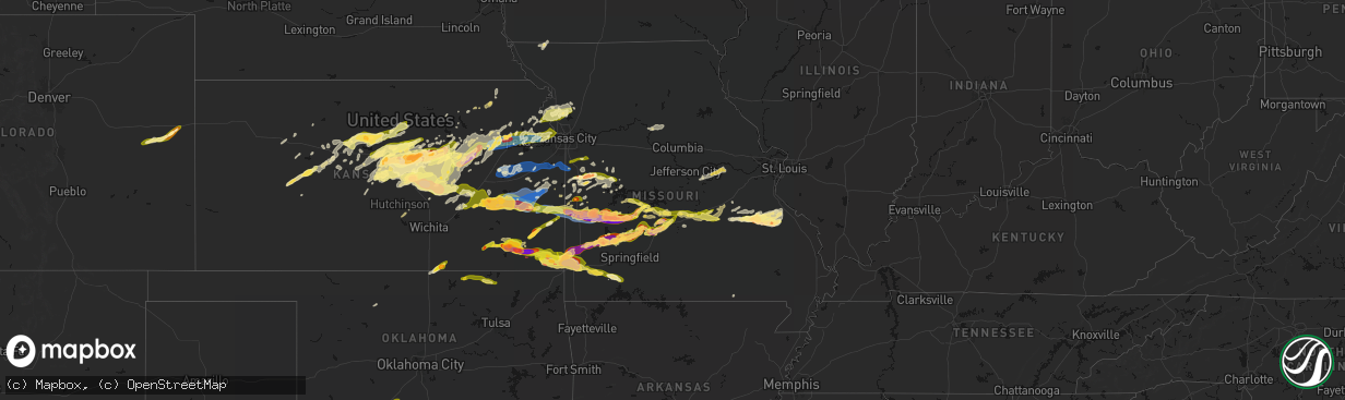
Hail Map in Missouri on April 26, 2026
The weather event in Missouri on April 26, 2026 includes Hail, Wind, and Tornado maps. 14 states and 766 cities were impacted and suffered possible damage. The total estimated number of properties impacted is 240,172.
Hail
Wind
Tornado
240,172
Estimated number of impacted properties by a 1.00" hail or larger82,817
Estimated number of impacted properties by a 1.75" hail or larger29,562
Estimated number of impacted properties by a 2.50" hail or largerStorm reports in Missouri
Missouri
| Date | Description |
|---|---|
| 04/26/20266:58 PM CDT | Damage to a brick building in collins. |
| 04/26/20266:58 PM CDT | A local report indicates 1.00 inch wind near Golden City |
| 04/26/20266:40 PM CDT | A local report indicates 2.75 inch wind near 3 ENE Caplinger Mills |
| 04/26/20266:30 PM CDT | Tree downed onto a shed in clinton... Mo. Report relayed via social media. Time estimated from radar. |
| 04/26/20266:29 PM CDT | Trees down near sparrowfoot campground. Report relayed via social media. Time estimated from radar. |
| 04/26/20266:28 PM CDT | Report relayed from social media. Time estimated from radar. |
| 04/26/20266:22 PM CDT | Report from mping - quarter |
| 04/26/20266:20 PM CDT | A local report indicates 2.75 inch wind near 1 SSW El Dorado Springs |
| 04/26/20266:20 PM CDT | A local report indicates 2.00 inch wind near 1 S El Dorado Springs |
| 04/26/20266:20 PM CDT | Report from mping ping pong ball |
| 04/26/20266:18 PM CDT | Reported at a hospital. |
| 04/26/20266:14 PM CDT | Several reports of downed wires and power outages near routes n and o. Time estimated from radar. |
| 04/26/20266:14 PM CDT | Image of baseball sized hail 2 miles southeast of el dorado springs. Time estimated via radar. |
| 04/26/20266:14 PM CDT | West of el dorado springs. |
| 04/26/20266:12 PM CDT | Report from mping half dollar |
| 04/26/20266:03 PM CDT | Windshield shattered due to tennis ball size hail. |
| 04/26/20266:00 PM CDT | Tree limbs down between creighton and urich. Report relayed via social media. Time estimated from radar. |
| 04/26/20265:54 PM CDT | Downed wires and power outages near route zz. Time estimated from radar. |
| 04/26/20265:50 PM CDT | Several rvs with roof damage from hail. |
| 04/26/20265:50 PM CDT | Social media report. Large tree downed onto property in butler. Time estimated from radar. |
| 04/26/20265:50 PM CDT | A local report indicates 1.75 inch wind near 1 WNW Nevada |
| 04/26/20265:50 PM CDT | Report from mping ping pong ball |
| 04/26/20265:49 PM CDT | Report from mping. Hen egg |
| 04/26/20265:40 PM CDT | A local report indicates 1.50 inch wind near Metz |
| 04/26/20265:27 PM CDT | Report of tree and power line down in adrian. Time estimated from radar. |
| 04/26/20265:27 PM CDT | Large tree down near second street. Social media report and video. Time confirmed from radar. |
| 04/26/20265:26 PM CDT | Several reports of downed power poles or downed wires near the peculiar area. Time estimated from radar. |
| 04/26/20265:07 PM CDT | Time estimated from radar. |
| 04/26/20265:07 PM CDT | Private weather sensor. |
| 04/26/20266:59 AM CDT | Report from mping: ping pong ball |
| 04/26/20266:59 AM CDT | Multiple power poles down. |
| 04/26/20266:54 AM CDT | Report from mping: quarter |
| 04/26/20266:50 AM CDT | Multiple 6-10 inch limbs down and dime size hail. |
| 04/26/20266:50 AM CDT | Tree across roadway. |
| 04/26/20266:46 AM CDT | Report from mping: half dollar |
| 04/26/20266:46 AM CDT | Quarter size hail report four blocks east of the university. |
| 04/26/20266:42 AM CDT | Report from mping: half dollar |
| 04/26/20266:21 AM CDT | Report from mping: quarter |
| 04/26/20266:20 AM CDT | A local report indicates 1.00 inch wind near 2 ENE Maplewood |
| 04/26/20266:19 AM CDT | Report from mping: quarter |
| 04/26/20266:18 AM CDT | Large tree snapped causing damage to roof. |
| 04/26/20266:16 AM CDT | Estimated ping pong sized hail with photo and us quarter. Time estimated from radar. |
| 04/26/20266:16 AM CDT | Report from mping: quarter |
| 04/26/20266:15 AM CDT | A local report indicates 1.50 inch wind near 1 N University City |
| 04/26/20266:15 AM CDT | Picture received on x. |
| 04/26/20266:15 AM CDT | Picture received on x from near kings highway and mlk dr. |
| 04/26/20266:15 AM CDT | A local report indicates 1.75 inch wind near 1 E University City |
| 04/26/20266:13 AM CDT | Trees uprooted. Report relayed via social media. Time estimated from radar. |
| 04/26/20266:10 AM CDT | Trees down... Damaging deck railing. Report relayed via social media. Corrected time estimated from radar. |
| 04/26/20265:28 AM CDT | A local report indicates 1.00 inch wind near 2 W Williamsville |
| 04/26/20265:10 AM CDT | Trees down... Damaging deck railing. Report relayed via social media. Time estimated from radar. |
| 04/26/20264:40 AM CDT | Upper portion of oak tree broken off. Report relayed via social media. Time estimated from radar. |
| 04/26/20264:33 AM CDT | Private weather sensor. |
| 04/26/20264:23 AM CDT | Trees down on route 13 south of kingston. Time estimated from radar. |
| 04/26/20264:20 AM CDT | Carport flipped. Report relayed via social media. Time estimated from radar. |
| 04/26/20264:18 AM CDT | Report from mping: hen egg |
| 04/26/20264:13 AM CDT | Shingles blown off house and minor property damage. Time and location estimated. |
| 04/26/20264:10 AM CDT | Trees across u.s. 69 south of highway 121. Time estimated from radar. |
| 04/26/20264:09 AM CDT | Semi blown over. Tree blown down. Time estimated from radar. |
| 04/26/20263:58 AM CDT | Report from mping: ping pong ball |
| 04/26/20263:54 AM CDT | Time estimated from radar. |
| 04/26/20263:54 AM CDT | Tree uprooted. Report relayed via social media. Time estimated from radar. |
| 04/26/20263:50 AM CDT | Report from mping: half dollar |
| 04/26/20263:44 AM CDT | Report from mping: ping pong ball |
| 04/26/20263:43 AM CDT | Tree partially snapped. Report relayed via social media. Time estimated from radar. |
| 04/26/20263:42 AM CDT | Small grill with full propane tank lifted and thrown. Report relayed via social media. Time estimated from radar. |
| 04/26/20263:41 AM CDT | Report from mping: quarter |
| 04/26/20263:39 AM CDT | Report from mping: golf ball |
| 04/26/20263:37 AM CDT | A local report indicates 1.25 inch wind near 1 NW Farmington |
| 04/26/20263:36 AM CDT | A local report indicates 1.75 inch wind near 3 SE Farmington |
| 04/26/20263:33 AM CDT | Time estimated from radar. |
| 04/26/20263:33 AM CDT | Time estimated from radar. |
| 04/26/20263:33 AM CDT | Time estimated from radar. |
| 04/26/20263:33 AM CDT | Report from mping: golf ball |
| 04/26/20263:33 AM CDT | Photo of multiple large hail stones... Largest is measured at 2 inches. Time estimated from radar. |
| 04/26/20263:33 AM CDT | Time estimated from radar. |
| 04/26/20263:30 AM CDT | Picture received on x. |
| 04/26/20263:29 AM CDT | Report from mping: quarter |
| 04/26/20263:29 AM CDT | Report from mping: quarter |
| 04/26/20263:20 AM CDT | Report from mping: hen egg |
| 04/26/20263:20 AM CDT | A local report indicates 2.50 inch wind near 2 NE Doe Run |
| 04/26/20263:18 AM CDT | Report from mping: golf ball |
| 04/26/20263:13 AM CDT | Report from mping: ping pong ball |
| 04/26/20263:08 AM CDT | A local report indicates 1.25 inch wind near Irondale |
| 04/26/20263:07 AM CDT | Time estimated from radar. |
| 04/26/20263:00 AM CDT | A local report indicates 1.00 inch wind near 3 SE Northwye |
| 04/26/20262:58 AM CDT | A local report indicates 1.00 inch wind near 1 SE Rolla |
| 04/26/20262:57 AM CDT | A local report indicates 1.75 inch wind near Caledonia |
| 04/26/20262:56 AM CDT | A local report indicates 1.25 inch wind near 1 WSW Rolla |
| 04/25/202611:08 PM CDT | Tree was downed. |
| 04/25/202610:39 PM CDT | Social media report and photo. |
| 04/25/202610:35 PM CDT | Social media report. Time estimated from radar. |
| 04/25/202610:26 PM CDT | Image received of golf ball sized hail just south of the lebanon airport. Time estimated via radar. |
| 04/25/202610:25 PM CDT | Social media video. Time estimated from radar. |
| 04/25/202610:25 PM CDT | A local report indicates 1.25 inch wind near 3 S Lebanon |
| 04/25/202610:22 PM CDT | Social media report. Time estimated from radar. |
| 04/25/202610:21 PM CDT | Image received of 2 inch hail. Time estimated via radar. |
| 04/25/202610:08 PM CDT | Image received of 3 inch hail. Time estimated via radar. |
| 04/25/20269:52 PM CDT | Several reports of downed wires and power outages in the archie area. Time estimated from radar. |
| 04/25/20268:17 PM CDT | A local report indicates 1.75 inch wind near Morrisville |
| 04/25/20268:07 PM CDT | A local report indicates 1.75 inch wind near Walnut Grove |
| 04/25/20267:43 PM CDT | A local report indicates 1.75 inch wind near 3 SSE Neola |
| 04/25/20267:42 PM CDT | A local report indicates 1.75 inch wind near 1 S Arcola |
| 04/25/20267:35 PM CDT | Report from mping - hen egg |
| 04/25/20267:32 PM CDT | Dade county line on stockton lake. |
| 04/25/20267:25 PM CDT | A local report indicates 1.50 inch wind near 4 ENE Elkton |
| 04/25/20267:21 PM CDT | Near greenfield. |
| 04/25/20267:17 PM CDT | Social media report. Time estimated from radar. |
| 04/25/20267:03 PM CDT | A local report indicates 1.00 inch wind near 2 WSW Flemington |
| 04/25/20267:01 PM CDT | A local report indicates 2.75 inch wind near Humansville |
| 04/25/20267:01 PM CDT | A local report indicates 2.00 inch wind near Humansville |
| 04/25/20267:01 PM CDT | A local report indicates 1.50 inch wind near Humansville |
All States Impacted by Hail Map on April 26, 2026
Cities Impacted by Hail Map on April 26, 2026
- Leonard, TX
- Celeste, TX
- Bailey, TX
- Wolfe City, TX
- Trenton, TX
- Ness City, KS
- Jefferson, TX
- Beeler, KS
- Liberty, MS
- Summit, MS
- Smithdale, MS
- Bonham, TX
- Soso, MS
- Taylorsville, MS
- Vivian, LA
- Karnack, TX
- Bazine, KS
- Brownell, KS
- Mooringsport, LA
- Franklinton, LA
- Amite, LA
- Kentwood, LA
- Mount Hermon, LA
- Ransom, KS
- Waynesboro, MS
- Laurel, MS
- Oil City, LA
- Shreveport, LA
- McCracken, KS
- Loranger, LA
- Folsom, LA
- Buckatunna, MS
- Millry, AL
- Hays, KS
- Schoenchen, KS
- Russell, KS
- Victoria, KS
- La Crosse, KS
- New Orleans, LA
- Bison, KS
- Otis, KS
- Violet, LA
- Hoisington, KS
- Bunker Hill, KS
- Dorrance, KS
- Claflin, KS
- Gorham, KS
- Ellinwood, KS
- Bushton, KS
- Geneseo, KS
- Lyons, KS
- Lorraine, KS
- Ellsworth, KS
- Wilson, KS
- Chase, KS
- Holyrood, KS
- Little River, KS
- Kanopolis, KS
- Marquette, KS
- Lindsborg, KS
- Mcpherson, KS
- Windom, KS
- Gypsum, KS
- Galva, KS
- Canton, KS
- Roxbury, KS
- Assaria, KS
- Durham, KS
- Lehigh, KS
- Tampa, KS
- Hillsboro, KS
- Hope, KS
- New Cambria, KS
- Abilene, KS
- Newton, KS
- Herington, KS
- Woodbine, KS
- Chapman, KS
- Enterprise, KS
- Walton, KS
- Peabody, KS
- Marion, KS
- White City, KS
- Lincolnville, KS
- Florence, KS
- Junction City, KS
- Ramona, KS
- Lost Springs, KS
- Dwight, KS
- Council Grove, KS
- Wilsey, KS
- Cedar Point, KS
- Elmdale, KS
- Bivins, TX
- Rodessa, LA
- Ida, LA
- Burns, KS
- Cottonwood Falls, KS
- Matfield Green, KS
- El Dorado, KS
- Cassoday, KS
- Olpe, KS
- Eureka, KS
- Salina, KS
- Solomon, KS
- Hamilton, KS
- Madison, KS
- Reading, KS
- Osage City, KS
- Lebo, KS
- Lyndon, KS
- Virgil, KS
- Gridley, KS
- Galesburg, KS
- Erie, KS
- Saint Paul, KS
- Burlington, KS
- Melvern, KS
- Quenemo, KS
- Vassar, KS
- Hartford, KS
- Manhattan, KS
- Carbondale, KS
- Wakarusa, KS
- Wamego, KS
- Pomona, KS
- Stark, KS
- Walnut, KS
- Uniontown, KS
- Yates Center, KS
- Le Roy, KS
- Scranton, KS
- Berryton, KS
- Overbrook, KS
- Ottawa, KS
- Williamsburg, KS
- Hepler, KS
- Fort Scott, KS
- Neosho Falls, KS
- Baldwin City, KS
- Wellsville, KS
- Redfield, KS
- Colony, KS
- Iola, KS
- Piqua, KS
- Westphalia, KS
- Garnett, KS
- Welda, KS
- Rantoul, KS
- Paola, KS
- Fort Lauderdale, FL
- Moran, KS
- La Harpe, KS
- Kincaid, KS
- Edgerton, KS
- Richmond, KS
- Princeton, KS
- Alma, KS
- Spring Hill, KS
- Parker, KS
- Centerville, KS
- Bronson, KS
- Blue Mound, KS
- Bucyrus, KS
- Louisburg, KS
- Iowa Park, TX
- Electra, TX
- Osawatomie, KS
- Mound City, KS
- La Cygne, KS
- Fontana, KS
- Greeley, KS
- Cleveland, MO
- Mapleton, KS
- Wichita Falls, TX
- Pleasanton, KS
- Fulton, KS
- Burkburnett, TX
- Grenola, KS
- Moline, KS
- Drexel, MO
- Freeman, MO
- Amoret, MO
- Columbia, MS
- Foster, MO
- Prescott, KS
- Amsterdam, MO
- Richards, MO
- Deerfield, MO
- Nevada, MO
- Moundville, MO
- Sheppard Afb, TX
- Hume, MO
- Elk Falls, KS
- Peculiar, MO
- Columbus, KS
- Galena, KS
- Sumrall, MS
- Butler, MO
- Carl Junction, MO
- Pittsburg, KS
- Weir, KS
- Lawton, OK
- Geronimo, OK
- Walters, OK
- Asbury, MO
- Purvis, MS
- Garden City, MO
- Creighton, MO
- Devol, OK
- Walker, MO
- Rich Hill, MO
- Randlett, OK
- Lumberton, MS
- El Dorado Springs, MO
- Harwood, MO
- Milo, MO
- Stockton, MO
- Webb City, MO
- Oronogo, MO
- Jasper, MO
- Rockville, MO
- Blairstown, MO
- Holden, MO
- Chilhowee, MO
- Appleton City, MO
- Longton, KS
- Hattiesburg, MS
- Grandfield, OK
- Purcell, MO
- Neck City, MO
- Duncan, OK
- Marlow, OK
- Elgin, OK
- Fletcher, OK
- Schell City, MO
- Osceola, MO
- Rush Springs, OK
- Fredonia, KS
- Elk City, KS
- Carthage, MO
- Alba, MO
- Leeton, MO
- Centerview, MO
- Ninnekah, OK
- Cement, OK
- Petrolia, TX
- Byers, TX
- Humansville, MO
- Collins, MO
- Golden City, MO
- Neodesha, KS
- Clinton, MO
- Lamar, MO
- Flemington, MO
- Weaubleau, MO
- Wheatland, MO
- Bolivar, MO
- Lockwood, MO
- Independence, KS
- Calhoun, MO
- Hortense, GA
- Warsaw, MO
- Shidler, OK
- Kaw City, OK
- Cherryvale, KS
- South Greenfield, MO
- Greenfield, MO
- Waynesville, GA
- Pittsburg, MO
- Polk, MO
- Hermitage, MO
- Arcola, MO
- Dadeville, MO
- Flagler, CO
- Everton, MO
- Deepwater, MO
- Dennis, KS
- Aldrich, MO
- Fair Play, MO
- Walnut Grove, MO
- Mound Valley, KS
- Parsons, KS
- Vona, CO
- Ash Grove, MO
- Half Way, MO
- Urbana, MO
- Preston, MO
- Morrisville, MO
- Kit Carson, CO
- Windsor, MO
- Stratton, CO
- Thayer, KS
- Pawhuska, OK
- Henrietta, TX
- Ryan, OK
- Altamont, KS
- Brighton, MO
- Pleasant Hope, MO
- Cross Timbers, MO
- Macks Creek, MO
- Climax Springs, MO
- Willard, MO
- Altoona, KS
- Bethune, CO
- Oswego, KS
- Burlington, CO
- Buffalo, MO
- Roach, MO
- Quincy, MO
- Lane, KS
- McCune, KS
- Elkland, MO
- Bartlesville, OK
- West Mineral, KS
- Scammon, KS
- Cherokee, KS
- Long Lane, MO
- Chetopa, KS
- Adrian, MO
- Louisburg, MO
- Tunas, MO
- Windyville, MO
- Archie, MO
- Baxter Springs, KS
- Phillipsburg, MO
- Harrisonville, MO
- Lowry City, MO
- Jetmore, KS
- Lebanon, MO
- Conway, MO
- Riverton, KS
- Joplin, MO
- Utica, KS
- Urich, MO
- Carterville, MO
- Duenweg, MO
- Diamond, MO
- Eldridge, MO
- Olmitz, KS
- Stoutland, MO
- Richland, MO
- Edwards, MO
- Pleasant Hill, MO
- Fairview, OK
- Cleo Springs, OK
- Montrose, MO
- Kingsville, MO
- Sarcoxie, MO
- Neosho, MO
- Granby, MO
- Camdenton, MO
- Helena, OK
- Reeds, MO
- Pierce City, MO
- Ellis, KS
- Fort Leonard Wood, MO
- Saint Robert, MO
- Waynesville, MO
- Wentworth, MO
- Burdick, KS
- Brookville, KS
- Wakeeney, KS
- Collyer, KS
- Stark City, MO
- Laquey, MO
- Green, KS
- Clay Center, KS
- Verona, MO
- Monett, MO
- Alta Vista, KS
- Strong City, KS
- Falun, KS
- Montreal, MO
- Corning, KS
- Walker, KS
- Paxico, KS
- Randolph, KS
- Seneca, KS
- Duke, MO
- Newburg, MO
- Catharine, KS
- Gilliam, MO
- Slater, MO
- Devils Elbow, MO
- Dixon, MO
- Crocker, MO
- Lincoln, KS
- Glasgow, MO
- Sylvan Grove, KS
- Beverly, KS
- Tescott, KS
- Topeka, KS
- Aurora, MO
- Crane, MO
- Armstrong, MO
- Rolla, MO
- Paradise, KS
- McFarland, KS
- Oneida, KS
- Quinter, KS
- Braman, OK
- Edgar Springs, MO
- Allen, KS
- Marionville, MO
- Galena, MO
- Higbee, MO
- Westmoreland, KS
- Onaga, KS
- Frankfort, KS
- Waldo, KS
- Geuda Springs, KS
- Newkirk, OK
- Bennington, KS
- Saint Marys, KS
- Rossville, KS
- Maple Hill, KS
- Eskridge, KS
- Minneapolis, KS
- Morland, KS
- Saint James, MO
- Cook Sta, MO
- Vermillion, KS
- Lucas, KS
- Luray, KS
- Arkansas City, KS
- Belvue, KS
- Falls City, NE
- Verdon, NE
- Shubert, NE
- Centralia, KS
- Jerome, MO
- Salem, MO
- Delia, KS
- Mayetta, KS
- Steelville, MO
- Kingman, KS
- Rock Port, MO
- Clark, MO
- Winfield, KS
- Hudson, KS
- Goff, KS
- Haven, KS
- Pretty Prairie, KS
- Hunter, KS
- Havensville, KS
- Barnard, KS
- Riley, KS
- Tarkio, MO
- Nortonville, KS
- Winchester, KS
- Fairfax, MO
- Linn Creek, MO
- Clearmont, MO
- Harveyville, KS
- Beloit, KS
- Elmo, MO
- Braddyville, IA
- Wakefield, KS
- Talmage, KS
- Milford, KS
- Cherryville, MO
- Delphos, KS
- Glasco, KS
- Davisville, MO
- Burrton, KS
- Fort Riley, KS
- Bogue, KS
- Ogden, KS
- Bourbon, MO
- Silver Lake, KS
- Potosi, MO
- McLouth, KS
- Loose Creek, MO
- Belgrade, MO
- Tecumseh, KS
- Grantville, KS
- Lecompton, KS
- Meriden, KS
- Perry, KS
- Hoyt, KS
- Atchison, KS
- Cummings, KS
- Linn, MO
- Lawrence, KS
- Caledonia, MO
- Irondale, MO
- Bonne Terre, MO
- Park Hills, MO
- Mineral Point, MO
- Leadwood, MO
- Bismarck, MO
- Rushville, MO
- Weston, MO
- Chamois, MO
- Ozawkie, KS
- Farlington, KS
- Valley Falls, KS
- Easton, KS
- Oskaloosa, KS
- Leavenworth, KS
- Fort Leavenworth, KS
- Platte City, MO
- Auburn, KS
- Tonganoxie, KS
- Hermann, MO
- Morrison, MO
- Farmington, MO
- Ironton, MO
- Doe Run, MO
- Mount Sterling, MO
- De Kalb, MO
- Dearborn, MO
- Camden Point, MO
- Gerald, MO
- Cuba, MO
- Basehor, KS
- Gower, MO
- Faucett, MO
- Linwood, KS
- Bloomsdale, MO
- Sainte Genevieve, MO
- French Village, MO
- Edgerton, MO
- Agency, MO
- Trimble, MO
- Berger, MO
- Smithville, MO
- Plattsburg, MO
- Bonner Springs, KS
- Kansas City, KS
- Lansing, KS
- New Haven, MO
- Lathrop, MO
- Couch, MO
- Leasburg, MO
- Turney, MO
- Cameron, MO
- Kingston, MO
- Polo, MO
- Riverside, MO
- Kansas City, MO
- Waldron, MO
- Excelsior Springs, MO
- Burlingame, KS
- Pacific, MO
- Eureka, MO
- Holt, MO
- Wildwood, MO
- Marthasville, MO
- Saint Mary, MO
- Liberty, MO
- Kearney, MO
- Kidder, MO
- Rayville, MO
- Lawson, MO
- Richmond, MO
- High Ridge, MO
- Warrenton, MO
- Fredericktown, MO
- Doniphan, MO
- Warrensburg, MO
- Warm Springs, AR
- Pocahontas, AR
- Cowgill, MO
- Hamilton, MO
- Fenton, MO
- Hardin, MO
- Norborne, MO
- Braymer, MO
- Gatewood, MO
- Wright City, MO
- Saint Louis, MO
- Sedalia, MO
- Breckenridge, MO
- Campbell Hill, IL
- Rockwood, IL
- Ava, IL
- Hughesville, MO
- Van Buren, MO
- Grandin, MO
- Vandalia, MO
- Dawn, MO
- Ludlow, MO
- Arnold, MO
- Lonedell, MO
- Saint Clair, MO
- Perryville, MO
- Gallatin, MO
- Sibley, MO
- Cadet, MO
- Carrollton, MO
- Piggott, AR
- Orrick, MO
- Bowling Green, MO
- Columbia, IL
- Curryville, MO
- Tina, MO
- Bogard, MO
- Robertsville, MO
- Luebbering, MO
- Marmaduke, AR
- Paragould, AR
- Jacob, IL
- Hale, MO
- Chillicothe, MO
- Fayette, MO
- Murphysboro, IL
- Poplar Bluff, MO
- Ellsinore, MO
- Williamsville, MO
- Pollard, AR
- Qulin, MO
- Gardner, KS
- Millstadt, IL
- Pinckneyville, IL
- Eudora, KS
- De Soto, KS
- Olathe, KS
- Vergennes, IL
- House Springs, MO
- Catawissa, MO
- Cedar Hill, MO
- New Century, KS
- Lenexa, KS
- Shawnee, KS
- Overland Park, KS
- Campbell, MO
- Frankford, MO
- Columbia, MO
- Broseley, MO
- Fisk, MO
- Belleville, IL
- Rector, AR
- Cardwell, MO
- Elkville, IL
- Du Quoin, IL
- Dowell, IL
- Grandview, MO
- Leawood, KS
- De Witt, MO
- Bernie, MO
- Malden, MO
- Stilwell, KS
- Belton, MO
- Freeburg, IL
- Scott Air Force Base, IL
- Dudley, MO
- Waverly, KS
- Kennett, MO
- Senath, MO
- Louisiana, MO
- Raymore, MO
- Mulkeytown, IL
- Royalton, IL
- New Canton, IL
- Rockport, IL
- Bloomfield, MO
- Dexter, MO
- Mexico, MO
- Nebo, IL
- Pleasant Hill, IL
- Rush Hill, MO
- Laddonia, MO
- Lees Summit, MO
- Greenwood, MO
- New Baden, IL
- Mascoutah, IL
- Fieldon, IL
- Benton City, MO
- Buckner, IL
- East Saint Louis, IL
- Miami, MO
- Brunswick, MO
- Ballwin, MO
- Pittsfield, IL
- Barry, IL
- Mendon, MO
- Keytesville, MO
- Marceline, MO
- Bell City, MO
- Vanduser, MO
- Sikeston, MO
- Oran, MO
- Benton, MO
- Albers, IL
- Dalton, MO
- Middletown, MO
- Farber, MO
- Chaffee, MO
- Salisbury, MO
- Caruthersville, MO
- Charleston, MO
- Advance, MO
- Saint Jacob, IL
- Lebanon, IL
- Troy, IL
- Eldred, IL
- Carrollton, IL
- Henrietta, MO
- Glen Carbon, IL
- Maryville, IL
- Lexington, MO
- Benton, IL
- Granite City, IL
- Rockbridge, IL
- Callao, MO
- Clarksville, MO
- Okawville, IL
- Bartelso, IL
- Germantown, IL
- Scott City, MO
- Cape Girardeau, MO
- New Cambria, MO
- Clifton Hill, MO
- Miller City, IL
- New Salem, IL
- Highland, IL
- Collinsville, IL
- Pearl, IL
- Bertrand, MO
- Lone Jack, MO
- Edwardsville, IL
- Chesterfield, MO
- Jonesboro, IL
- McClure, IL
- Carlyle, IL
- Centralia, IL
- Hoyleton, IL
- Roxana, IL
- Hartford, IL
- Bethalto, IL
- Wood River, IL
- South Roxana, IL
- Huntsville, MO
- Bevier, MO
- Excello, MO
- Jacksonville, MO
- Macon, MO
- Anabel, MO
- Mounds, IL
- Cairo, IL
- Thebes, IL
- Villa Ridge, IL
- Pulaski, IL
- Tamms, IL
- Mission, KS
- Macedonia, IL
- White Hall, IL
- Bosworth, MO
- Medora, IL
- East Alton, IL
- Winchester, IL
- Triplett, MO
- Greenfield, IL
- Jerseyville, IL
- Alhambra, IL
- New Douglas, IL
- East Prairie, MO
- Malta Bend, MO
- Marshall, MO
- Hutchinson, KS
- Venice, IL
- Madison, IL
- Moberly, MO
- Madison, MO


