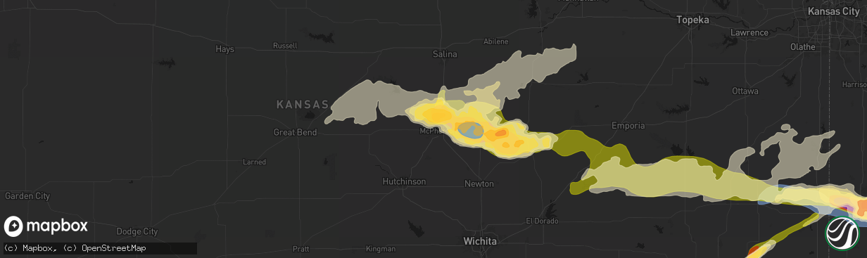
Hail Map in Mcpherson, KS on April 26, 2026
The weather event in Mcpherson, KS on April 26, 2026 includes Hail, Wind, and Tornado maps. 14 states and 766 cities were impacted and suffered possible damage. The total estimated number of properties impacted is 3,459.
Hail
Wind
Tornado
3,459
Estimated number of impacted properties by a 1.00" hail or larger876
Estimated number of impacted properties by a 1.75" hail or larger0
Estimated number of impacted properties by a 2.50" hail or largerStorm reports in Mcpherson, KS
Mcpherson, KS
| Date | Description |
|---|---|
| 04/26/20262:15 PM CDT | Delayed report from mping. |
| 04/26/202612:30 PM CDT | Time estimated from radar. |
| 04/26/202612:08 PM CDT | A local report indicates 1.00 inch wind near 1 NE Mcpherson |
| 04/26/202612:05 PM CDT | A local report indicates 1.75 inch wind near 7 NNE Mcpherson |
| 04/25/202611:35 PM CDT | A local report indicates 1.00 inch wind near 6 S Lindsborg |
| 04/25/202611:35 PM CDT | A local report indicates 1.75 inch wind near 5 N Mcpherson |
| 04/25/202611:35 PM CDT | Report from mping: quarter |
All States Impacted by Hail Map on April 26, 2026
All Cities Impacted by Hail Map on April 26, 2026
- Leonard, TX
- Celeste, TX
- Bailey, TX
- Wolfe City, TX
- Trenton, TX
- Ness City, KS
- Jefferson, TX
- Beeler, KS
- Liberty, MS
- Summit, MS
- Smithdale, MS
- Bonham, TX
- Soso, MS
- Taylorsville, MS
- Vivian, LA
- Karnack, TX
- Bazine, KS
- Brownell, KS
- Mooringsport, LA
- Franklinton, LA
- Amite, LA
- Kentwood, LA
- Mount Hermon, LA
- Ransom, KS
- Waynesboro, MS
- Laurel, MS
- Oil City, LA
- Shreveport, LA
- McCracken, KS
- Loranger, LA
- Folsom, LA
- Buckatunna, MS
- Millry, AL
- Hays, KS
- Schoenchen, KS
- Russell, KS
- Victoria, KS
- La Crosse, KS
- New Orleans, LA
- Bison, KS
- Otis, KS
- Violet, LA
- Hoisington, KS
- Bunker Hill, KS
- Dorrance, KS
- Claflin, KS
- Gorham, KS
- Ellinwood, KS
- Bushton, KS
- Geneseo, KS
- Lyons, KS
- Lorraine, KS
- Ellsworth, KS
- Wilson, KS
- Chase, KS
- Holyrood, KS
- Little River, KS
- Kanopolis, KS
- Marquette, KS
- Lindsborg, KS
- Mcpherson, KS
- Windom, KS
- Gypsum, KS
- Galva, KS
- Canton, KS
- Roxbury, KS
- Assaria, KS
- Durham, KS
- Lehigh, KS
- Tampa, KS
- Hillsboro, KS
- Hope, KS
- New Cambria, KS
- Abilene, KS
- Newton, KS
- Herington, KS
- Woodbine, KS
- Chapman, KS
- Enterprise, KS
- Walton, KS
- Peabody, KS
- Marion, KS
- White City, KS
- Lincolnville, KS
- Florence, KS
- Junction City, KS
- Ramona, KS
- Lost Springs, KS
- Dwight, KS
- Council Grove, KS
- Wilsey, KS
- Cedar Point, KS
- Elmdale, KS
- Bivins, TX
- Rodessa, LA
- Ida, LA
- Burns, KS
- Cottonwood Falls, KS
- Matfield Green, KS
- El Dorado, KS
- Cassoday, KS
- Olpe, KS
- Eureka, KS
- Salina, KS
- Solomon, KS
- Hamilton, KS
- Madison, KS
- Reading, KS
- Osage City, KS
- Lebo, KS
- Lyndon, KS
- Virgil, KS
- Gridley, KS
- Galesburg, KS
- Erie, KS
- Saint Paul, KS
- Burlington, KS
- Melvern, KS
- Quenemo, KS
- Vassar, KS
- Hartford, KS
- Manhattan, KS
- Carbondale, KS
- Wakarusa, KS
- Wamego, KS
- Pomona, KS
- Stark, KS
- Walnut, KS
- Uniontown, KS
- Yates Center, KS
- Le Roy, KS
- Scranton, KS
- Berryton, KS
- Overbrook, KS
- Ottawa, KS
- Williamsburg, KS
- Hepler, KS
- Fort Scott, KS
- Neosho Falls, KS
- Baldwin City, KS
- Wellsville, KS
- Redfield, KS
- Colony, KS
- Iola, KS
- Piqua, KS
- Westphalia, KS
- Garnett, KS
- Welda, KS
- Rantoul, KS
- Paola, KS
- Fort Lauderdale, FL
- Moran, KS
- La Harpe, KS
- Kincaid, KS
- Edgerton, KS
- Richmond, KS
- Princeton, KS
- Alma, KS
- Spring Hill, KS
- Parker, KS
- Centerville, KS
- Bronson, KS
- Blue Mound, KS
- Bucyrus, KS
- Louisburg, KS
- Iowa Park, TX
- Electra, TX
- Osawatomie, KS
- Mound City, KS
- La Cygne, KS
- Fontana, KS
- Greeley, KS
- Cleveland, MO
- Mapleton, KS
- Wichita Falls, TX
- Pleasanton, KS
- Fulton, KS
- Burkburnett, TX
- Grenola, KS
- Moline, KS
- Drexel, MO
- Freeman, MO
- Amoret, MO
- Columbia, MS
- Foster, MO
- Prescott, KS
- Amsterdam, MO
- Richards, MO
- Deerfield, MO
- Nevada, MO
- Moundville, MO
- Sheppard Afb, TX
- Hume, MO
- Elk Falls, KS
- Peculiar, MO
- Columbus, KS
- Galena, KS
- Sumrall, MS
- Butler, MO
- Carl Junction, MO
- Pittsburg, KS
- Weir, KS
- Lawton, OK
- Geronimo, OK
- Walters, OK
- Asbury, MO
- Purvis, MS
- Garden City, MO
- Creighton, MO
- Devol, OK
- Walker, MO
- Rich Hill, MO
- Randlett, OK
- Lumberton, MS
- El Dorado Springs, MO
- Harwood, MO
- Milo, MO
- Stockton, MO
- Webb City, MO
- Oronogo, MO
- Jasper, MO
- Rockville, MO
- Blairstown, MO
- Holden, MO
- Chilhowee, MO
- Appleton City, MO
- Longton, KS
- Hattiesburg, MS
- Grandfield, OK
- Purcell, MO
- Neck City, MO
- Duncan, OK
- Marlow, OK
- Elgin, OK
- Fletcher, OK
- Schell City, MO
- Osceola, MO
- Rush Springs, OK
- Fredonia, KS
- Elk City, KS
- Carthage, MO
- Alba, MO
- Leeton, MO
- Centerview, MO
- Ninnekah, OK
- Cement, OK
- Petrolia, TX
- Byers, TX
- Humansville, MO
- Collins, MO
- Golden City, MO
- Neodesha, KS
- Clinton, MO
- Lamar, MO
- Flemington, MO
- Weaubleau, MO
- Wheatland, MO
- Bolivar, MO
- Lockwood, MO
- Independence, KS
- Calhoun, MO
- Hortense, GA
- Warsaw, MO
- Shidler, OK
- Kaw City, OK
- Cherryvale, KS
- South Greenfield, MO
- Greenfield, MO
- Waynesville, GA
- Pittsburg, MO
- Polk, MO
- Hermitage, MO
- Arcola, MO
- Dadeville, MO
- Flagler, CO
- Everton, MO
- Deepwater, MO
- Dennis, KS
- Aldrich, MO
- Fair Play, MO
- Walnut Grove, MO
- Mound Valley, KS
- Parsons, KS
- Vona, CO
- Ash Grove, MO
- Half Way, MO
- Urbana, MO
- Preston, MO
- Morrisville, MO
- Kit Carson, CO
- Windsor, MO
- Stratton, CO
- Thayer, KS
- Pawhuska, OK
- Henrietta, TX
- Ryan, OK
- Altamont, KS
- Brighton, MO
- Pleasant Hope, MO
- Cross Timbers, MO
- Macks Creek, MO
- Climax Springs, MO
- Willard, MO
- Altoona, KS
- Bethune, CO
- Oswego, KS
- Burlington, CO
- Buffalo, MO
- Roach, MO
- Quincy, MO
- Lane, KS
- McCune, KS
- Elkland, MO
- Bartlesville, OK
- West Mineral, KS
- Scammon, KS
- Cherokee, KS
- Long Lane, MO
- Chetopa, KS
- Adrian, MO
- Louisburg, MO
- Tunas, MO
- Windyville, MO
- Archie, MO
- Baxter Springs, KS
- Phillipsburg, MO
- Harrisonville, MO
- Lowry City, MO
- Jetmore, KS
- Lebanon, MO
- Conway, MO
- Riverton, KS
- Joplin, MO
- Utica, KS
- Urich, MO
- Carterville, MO
- Duenweg, MO
- Diamond, MO
- Eldridge, MO
- Olmitz, KS
- Stoutland, MO
- Richland, MO
- Edwards, MO
- Pleasant Hill, MO
- Fairview, OK
- Cleo Springs, OK
- Montrose, MO
- Kingsville, MO
- Sarcoxie, MO
- Neosho, MO
- Granby, MO
- Camdenton, MO
- Helena, OK
- Reeds, MO
- Pierce City, MO
- Ellis, KS
- Fort Leonard Wood, MO
- Saint Robert, MO
- Waynesville, MO
- Wentworth, MO
- Burdick, KS
- Brookville, KS
- Wakeeney, KS
- Collyer, KS
- Stark City, MO
- Laquey, MO
- Green, KS
- Clay Center, KS
- Verona, MO
- Monett, MO
- Alta Vista, KS
- Strong City, KS
- Falun, KS
- Montreal, MO
- Corning, KS
- Walker, KS
- Paxico, KS
- Randolph, KS
- Seneca, KS
- Duke, MO
- Newburg, MO
- Catharine, KS
- Gilliam, MO
- Slater, MO
- Devils Elbow, MO
- Dixon, MO
- Crocker, MO
- Lincoln, KS
- Glasgow, MO
- Sylvan Grove, KS
- Beverly, KS
- Tescott, KS
- Topeka, KS
- Aurora, MO
- Crane, MO
- Armstrong, MO
- Rolla, MO
- Paradise, KS
- McFarland, KS
- Oneida, KS
- Quinter, KS
- Braman, OK
- Edgar Springs, MO
- Allen, KS
- Marionville, MO
- Galena, MO
- Higbee, MO
- Westmoreland, KS
- Onaga, KS
- Frankfort, KS
- Waldo, KS
- Geuda Springs, KS
- Newkirk, OK
- Bennington, KS
- Saint Marys, KS
- Rossville, KS
- Maple Hill, KS
- Eskridge, KS
- Minneapolis, KS
- Morland, KS
- Saint James, MO
- Cook Sta, MO
- Vermillion, KS
- Lucas, KS
- Luray, KS
- Arkansas City, KS
- Belvue, KS
- Falls City, NE
- Verdon, NE
- Shubert, NE
- Centralia, KS
- Jerome, MO
- Salem, MO
- Delia, KS
- Mayetta, KS
- Steelville, MO
- Kingman, KS
- Rock Port, MO
- Clark, MO
- Winfield, KS
- Hudson, KS
- Goff, KS
- Haven, KS
- Pretty Prairie, KS
- Hunter, KS
- Havensville, KS
- Barnard, KS
- Riley, KS
- Tarkio, MO
- Nortonville, KS
- Winchester, KS
- Fairfax, MO
- Linn Creek, MO
- Clearmont, MO
- Harveyville, KS
- Beloit, KS
- Elmo, MO
- Braddyville, IA
- Wakefield, KS
- Talmage, KS
- Milford, KS
- Cherryville, MO
- Delphos, KS
- Glasco, KS
- Davisville, MO
- Burrton, KS
- Fort Riley, KS
- Bogue, KS
- Ogden, KS
- Bourbon, MO
- Silver Lake, KS
- Potosi, MO
- McLouth, KS
- Loose Creek, MO
- Belgrade, MO
- Tecumseh, KS
- Grantville, KS
- Lecompton, KS
- Meriden, KS
- Perry, KS
- Hoyt, KS
- Atchison, KS
- Cummings, KS
- Linn, MO
- Lawrence, KS
- Caledonia, MO
- Irondale, MO
- Bonne Terre, MO
- Park Hills, MO
- Mineral Point, MO
- Leadwood, MO
- Bismarck, MO
- Rushville, MO
- Weston, MO
- Chamois, MO
- Ozawkie, KS
- Farlington, KS
- Valley Falls, KS
- Easton, KS
- Oskaloosa, KS
- Leavenworth, KS
- Fort Leavenworth, KS
- Platte City, MO
- Auburn, KS
- Tonganoxie, KS
- Hermann, MO
- Morrison, MO
- Farmington, MO
- Ironton, MO
- Doe Run, MO
- Mount Sterling, MO
- De Kalb, MO
- Dearborn, MO
- Camden Point, MO
- Gerald, MO
- Cuba, MO
- Basehor, KS
- Gower, MO
- Faucett, MO
- Linwood, KS
- Bloomsdale, MO
- Sainte Genevieve, MO
- French Village, MO
- Edgerton, MO
- Agency, MO
- Trimble, MO
- Berger, MO
- Smithville, MO
- Plattsburg, MO
- Bonner Springs, KS
- Kansas City, KS
- Lansing, KS
- New Haven, MO
- Lathrop, MO
- Couch, MO
- Leasburg, MO
- Turney, MO
- Cameron, MO
- Kingston, MO
- Polo, MO
- Riverside, MO
- Kansas City, MO
- Waldron, MO
- Excelsior Springs, MO
- Burlingame, KS
- Pacific, MO
- Eureka, MO
- Holt, MO
- Wildwood, MO
- Marthasville, MO
- Saint Mary, MO
- Liberty, MO
- Kearney, MO
- Kidder, MO
- Rayville, MO
- Lawson, MO
- Richmond, MO
- High Ridge, MO
- Warrenton, MO
- Fredericktown, MO
- Doniphan, MO
- Warrensburg, MO
- Warm Springs, AR
- Pocahontas, AR
- Cowgill, MO
- Hamilton, MO
- Fenton, MO
- Hardin, MO
- Norborne, MO
- Braymer, MO
- Gatewood, MO
- Wright City, MO
- Saint Louis, MO
- Sedalia, MO
- Breckenridge, MO
- Campbell Hill, IL
- Rockwood, IL
- Ava, IL
- Hughesville, MO
- Van Buren, MO
- Grandin, MO
- Vandalia, MO
- Dawn, MO
- Ludlow, MO
- Arnold, MO
- Lonedell, MO
- Saint Clair, MO
- Perryville, MO
- Gallatin, MO
- Sibley, MO
- Cadet, MO
- Carrollton, MO
- Piggott, AR
- Orrick, MO
- Bowling Green, MO
- Columbia, IL
- Curryville, MO
- Tina, MO
- Bogard, MO
- Robertsville, MO
- Luebbering, MO
- Marmaduke, AR
- Paragould, AR
- Jacob, IL
- Hale, MO
- Chillicothe, MO
- Fayette, MO
- Murphysboro, IL
- Poplar Bluff, MO
- Ellsinore, MO
- Williamsville, MO
- Pollard, AR
- Qulin, MO
- Gardner, KS
- Millstadt, IL
- Pinckneyville, IL
- Eudora, KS
- De Soto, KS
- Olathe, KS
- Vergennes, IL
- House Springs, MO
- Catawissa, MO
- Cedar Hill, MO
- New Century, KS
- Lenexa, KS
- Shawnee, KS
- Overland Park, KS
- Campbell, MO
- Frankford, MO
- Columbia, MO
- Broseley, MO
- Fisk, MO
- Belleville, IL
- Rector, AR
- Cardwell, MO
- Elkville, IL
- Du Quoin, IL
- Dowell, IL
- Grandview, MO
- Leawood, KS
- De Witt, MO
- Bernie, MO
- Malden, MO
- Stilwell, KS
- Belton, MO
- Freeburg, IL
- Scott Air Force Base, IL
- Dudley, MO
- Waverly, KS
- Kennett, MO
- Senath, MO
- Louisiana, MO
- Raymore, MO
- Mulkeytown, IL
- Royalton, IL
- New Canton, IL
- Rockport, IL
- Bloomfield, MO
- Dexter, MO
- Mexico, MO
- Nebo, IL
- Pleasant Hill, IL
- Rush Hill, MO
- Laddonia, MO
- Lees Summit, MO
- Greenwood, MO
- New Baden, IL
- Mascoutah, IL
- Fieldon, IL
- Benton City, MO
- Buckner, IL
- East Saint Louis, IL
- Miami, MO
- Brunswick, MO
- Ballwin, MO
- Pittsfield, IL
- Barry, IL
- Mendon, MO
- Keytesville, MO
- Marceline, MO
- Bell City, MO
- Vanduser, MO
- Sikeston, MO
- Oran, MO
- Benton, MO
- Albers, IL
- Dalton, MO
- Middletown, MO
- Farber, MO
- Chaffee, MO
- Salisbury, MO
- Caruthersville, MO
- Charleston, MO
- Advance, MO
- Saint Jacob, IL
- Lebanon, IL
- Troy, IL
- Eldred, IL
- Carrollton, IL
- Henrietta, MO
- Glen Carbon, IL
- Maryville, IL
- Lexington, MO
- Benton, IL
- Granite City, IL
- Rockbridge, IL
- Callao, MO
- Clarksville, MO
- Okawville, IL
- Bartelso, IL
- Germantown, IL
- Scott City, MO
- Cape Girardeau, MO
- New Cambria, MO
- Clifton Hill, MO
- Miller City, IL
- New Salem, IL
- Highland, IL
- Collinsville, IL
- Pearl, IL
- Bertrand, MO
- Lone Jack, MO
- Edwardsville, IL
- Chesterfield, MO
- Jonesboro, IL
- McClure, IL
- Carlyle, IL
- Centralia, IL
- Hoyleton, IL
- Roxana, IL
- Hartford, IL
- Bethalto, IL
- Wood River, IL
- South Roxana, IL
- Huntsville, MO
- Bevier, MO
- Excello, MO
- Jacksonville, MO
- Macon, MO
- Anabel, MO
- Mounds, IL
- Cairo, IL
- Thebes, IL
- Villa Ridge, IL
- Pulaski, IL
- Tamms, IL
- Mission, KS
- Macedonia, IL
- White Hall, IL
- Bosworth, MO
- Medora, IL
- East Alton, IL
- Winchester, IL
- Triplett, MO
- Greenfield, IL
- Jerseyville, IL
- Alhambra, IL
- New Douglas, IL
- East Prairie, MO
- Malta Bend, MO
- Marshall, MO
- Hutchinson, KS
- Venice, IL
- Madison, IL
- Moberly, MO
- Madison, MO


