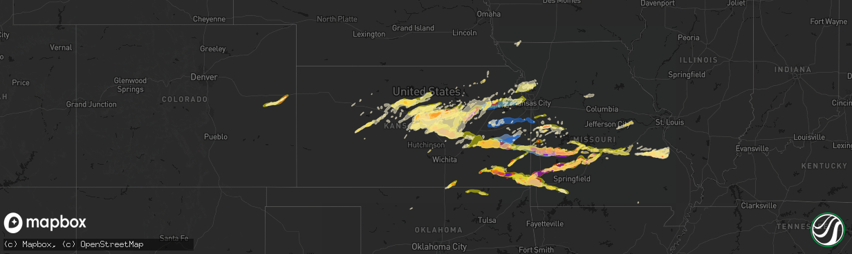
Hail Map in Kansas on April 26, 2026
The weather event in Kansas on April 26, 2026 includes Hail, Wind, and Tornado maps. 14 states and 766 cities were impacted and suffered possible damage. The total estimated number of properties impacted is 289,428.
Hail
Wind
Tornado
289,428
Estimated number of impacted properties by a 1.00" hail or larger53,433
Estimated number of impacted properties by a 1.75" hail or larger16,849
Estimated number of impacted properties by a 2.50" hail or largerStorm reports in Kansas
Kansas
| Date | Description |
|---|---|
| 04/26/20266:47 PM CDT | Report of brief tornado touchdown. |
| 04/26/20265:15 PM CDT | Downed wires and power outages near watties road. Time estimated from radar. |
| 04/26/20265:03 PM CDT | Downed wires near belleview road. Time estimated from radar. |
| 04/26/20264:59 PM CDT | Downed wires and power outages near delmont drive. Time estimated from radar. |
| 04/26/20264:56 PM CDT | Corrects previous tstm wnd dmg report from bucyrus. Downed trees and blown down fence at a residence near bucyrus. Time estimated from radar. |
| 04/26/20264:40 PM CDT | Report via personal weather station. |
| 04/26/20264:38 PM CDT | Private weather sensor. |
| 04/26/20264:29 PM CDT | Several downed trees southwest of hillsdale lake. Time estimated from radar. |
| 04/26/20264:20 PM CDT | Homes damaged and barn destroyed. Time estimated from radar. |
| 04/26/20264:18 PM CDT | Quarter hail broke one glass window. |
| 04/26/20264:13 PM CDT | A local report indicates 1.00 inch wind near 4 NW Iola |
| 04/26/20264:12 PM CDT | Social media picture of quarter size hail in fort scott... Kansas. |
| 04/26/20264:07 PM CDT | 0.5 inch hail. |
| 04/26/20264:03 PM CDT | 80+ mph winds estimated with quarter sized hail reported 9 ne of yates center. |
| 04/26/20263:52 PM CDT | A local report indicates 1.50 inch wind near 1 W Gridley |
| 04/26/20263:52 PM CDT | A local report indicates 1.00 inch wind near 9 N Yates Center |
| 04/26/20263:52 PM CDT | A local report indicates 1.50 inch wind near 4 SW Le Roy |
| 04/26/20263:49 PM CDT | Estimated 65 mph with pea sized hail. |
| 04/26/20263:48 PM CDT | A local report indicates 1.00 inch wind near 6 W Le Roy |
| 04/26/20263:45 PM CDT | A local report indicates 60 MPH wind near 9 N Yates Center |
| 04/26/20263:34 PM CDT | A local report indicates 60 MPH wind near Lyndon |
| 04/26/20263:29 PM CDT | A local report indicates 1.25 inch wind near Gridley |
| 04/26/20263:17 PM CDT | Public report of hail between 1.5 and 2 inches in diameter or just slightly smaller than a golf ball. |
| 04/26/20263:08 PM CDT | A local report indicates 2.00 inch wind near Madison |
| 04/26/20263:03 PM CDT | A local report indicates 1.00 inch wind near 3 NW Madison |
| 04/26/20263:03 PM CDT | Measured with hand held anemometer. |
| 04/26/20262:37 PM CDT | Delayed report from mping. |
| 04/26/20262:34 PM CDT | A local report indicates 1.00 inch wind near 2 SE Cassoday |
| 04/26/20262:15 PM CDT | Delayed report from mping. |
| 04/26/20261:32 PM CDT | A local report indicates 1.00 inch wind near Florence |
| 04/26/20261:23 PM CDT | Picture of 1 1/4 inch hail. |
| 04/26/20261:13 PM CDT | A local report indicates 1.00 inch wind near Hillsboro |
| 04/26/20261:13 PM CDT | Delayed report of 1 inch hail. |
| 04/26/20261:08 PM CDT | A local report indicates 1.00 inch wind near 4 W White City |
| 04/26/20261:06 PM CDT | Delayed report from mping: ping pong ball |
| 04/26/202612:57 PM CDT | Report of tree through roof at house in lehigh. |
| 04/26/202612:55 PM CDT | A local report indicates 1.75 inch wind near Hillsboro |
| 04/26/202612:52 PM CDT | Piles of quarter size hail. |
| 04/26/202612:50 PM CDT | A local report indicates 1.00 inch wind near 6 NNW Hope |
| 04/26/202612:45 PM CDT | Quarter size according to fire chief. |
| 04/26/202612:32 PM CDT | A local report indicates 70 MPH wind near Canton |
| 04/26/202612:32 PM CDT | Half dollar hail size piling up. |
| 04/26/202612:30 PM CDT | Time estimated from radar. |
| 04/26/202612:29 PM CDT | A local report indicates 1.00 inch wind near Carlton |
| 04/26/202612:18 PM CDT | Delayed report from mping. |
| 04/26/202612:08 PM CDT | A local report indicates 1.00 inch wind near 1 NE Mcpherson |
| 04/26/202612:05 PM CDT | A local report indicates 1.75 inch wind near 7 NNE Mcpherson |
| 04/26/202611:06 AM CDT | A local report indicates 1.00 inch wind near Geneseo |
| 04/26/20269:55 AM CDT | Damaged and broken power poles reported in columbus... Ks. |
| 04/26/20266:05 AM CDT | A local report indicates 1.00 inch wind near 1 NW Stanley |
| 04/26/20266:00 AM CDT | Report from mping: half dollar |
| 04/26/20265:56 AM CDT | Report from mping: half dollar |
| 04/26/20265:50 AM CDT | Report from mping: quarter |
| 04/26/20265:48 AM CDT | A local report indicates 1.00 inch wind near 1 SE Olathe |
| 04/26/20265:47 AM CDT | Report relayed from social media. Time estimated from radar. |
| 04/26/20265:46 AM CDT | Spotter called in... Reported hail between 3/4 and 1 3/4 between 5:42-5:46am... Time confirmed from radar. |
| 04/26/20265:46 AM CDT | Report from mping: half dollar |
| 04/26/20265:43 AM CDT | Report from mping: quarter |
| 04/26/20265:42 AM CDT | Report from mping: quarter |
| 04/26/20265:41 AM CDT | Report from mping: quarter |
| 04/26/20265:33 AM CDT | Report from mping: half dollar |
| 04/26/20265:32 AM CDT | Report from mping: quarter |
| 04/26/20265:14 AM CDT | 6 inch tree limb blocking tennessee street. Time estimated from radar. |
| 04/26/20265:12 AM CDT | Delayed report. A few 6-8 inch tree branches down in the area. Time estimated from radar. |
| 04/26/20265:11 AM CDT | Delayed report. Mping report of half dollar size hail. |
| 04/26/20265:05 AM CDT | Delayed report. |
| 04/26/20263:58 AM CDT | A local report indicates 1.00 inch wind near 1 NNW Maywood |
| 04/26/20263:58 AM CDT | A local report indicates 69 MPH wind near 1 NNW Maywood |
| 04/26/20263:56 AM CDT | A local report indicates 1.00 inch wind near 2 ENE Tonganoxie |
| 04/26/20263:55 AM CDT | Report from mping: quarter |
| 04/26/20263:51 AM CDT | Power lines downed. |
| 04/26/20263:50 AM CDT | Private weather sensor. |
| 04/26/20263:49 AM CDT | Private weather sensor. |
| 04/26/20263:43 AM CDT | A local report indicates 70 MPH wind near Tonganoxie |
| 04/26/20263:40 AM CDT | Report from mping: quarter |
| 04/26/20263:38 AM CDT | A local report indicates 1.00 inch wind near 2 N Tonganoxie |
| 04/26/20263:31 AM CDT | Personal weather station. |
| 04/26/20263:15 AM CDT | Large tree branches snapped. Report relayed via social media. Time estimated from radar. |
| 04/26/20262:58 AM CDT | Report from mping: quarter |
| 04/26/20262:57 AM CDT | A local report indicates 1.00 inch wind near 7 SSE Silver Lake |
| 04/26/20262:57 AM CDT | Report from mping: quarter |
| 04/26/20262:54 AM CDT | At the nws office. |
| 04/26/20262:53 AM CDT | Report from mping: quarter |
| 04/26/20262:52 AM CDT | A local report indicates 70 MPH wind near 3 N Topeka |
| 04/26/20262:50 AM CDT | Personal weather station. |
| 04/26/20262:50 AM CDT | A local report indicates 1.50 inch wind near 3 WNW Topeka |
| 04/26/20262:50 AM CDT | A local report indicates 1.75 inch wind near 4 NW Topeka |
| 04/26/20262:49 AM CDT | Report from mping: quarter |
| 04/26/20262:48 AM CDT | Personal weather station. |
| 04/26/20262:48 AM CDT | A local report indicates 1.00 inch wind near 3 NNW Pauline |
| 04/26/20262:45 AM CDT | Also estimating 50 mph winds with the hail. |
| 04/26/20262:42 AM CDT | Ktop asos. |
| 04/26/20262:40 AM CDT | A local report indicates 1.00 inch wind near 7 SSE Silver Lake |
| 04/26/20262:30 AM CDT | Personal weather station. |
| 04/26/20262:20 AM CDT | Lawn furniture is being blown around and things knocking into the house. |
| 04/26/20261:58 AM CDT | Off-duty nws employee. |
| 04/26/20261:37 AM CDT | A local report indicates 1.00 inch wind near Alta Vista |
| 04/26/20261:29 AM CDT | A local report indicates 1.00 inch wind near 6 N Sylvan Grove |
| 04/26/20261:28 AM CDT | A local report indicates 1.00 inch wind near 2 WSW Junction City |
| 04/26/20261:15 AM CDT | A local report indicates 1.50 inch wind near Lucas |
| 04/26/20261:03 AM CDT | A local report indicates 1.50 inch wind near Arkansas City |
| 04/26/20261:03 AM CDT | A local report indicates 1.25 inch wind near 1 NW Arkansas City |
| 04/26/20261:02 AM CDT | Report from mping: quarter |
| 04/26/20261:02 AM CDT | A local report indicates 1.50 inch wind near Arkansas City |
| 04/26/20261:01 AM CDT | A local report indicates 1.25 inch wind near 1 NW Arkansas City |
| 04/26/202612:54 AM CDT | Report from mping: quarter |
| 04/26/202612:48 AM CDT | A local report indicates 1.00 inch wind near 8 N Russell |
| 04/26/202612:46 AM CDT | A local report indicates 1.00 inch wind near Solomon |
| 04/26/202612:41 AM CDT | Report from mping: hen egg |
| 04/26/202612:37 AM CDT | Report from mping: hen egg |
| 04/26/202612:34 AM CDT | Report from mping: half dollar |
| 04/26/202612:32 AM CDT | Report from mping: quarter |
| 04/26/202612:31 AM CDT | Report from mping: hen egg |
| 04/26/202612:30 AM CDT | Report from mping: quarter |
| 04/26/202612:29 AM CDT | A local report indicates 1.50 inch wind near 2 S Salina |
| 04/26/202612:28 AM CDT | A local report indicates 2.00 inch wind near 6 SW Salina |
| 04/26/202612:27 AM CDT | A local report indicates 2.00 inch wind near 2 SSW Salina |
| 04/26/202612:27 AM CDT | A local report indicates 1.50 inch wind near 1 NNE Salina |
| 04/26/202612:23 AM CDT | A local report indicates 1.25 inch wind near 2 SW Smolan |
| 04/26/202612:10 AM CDT | Also estimated wind gusts of 45 to 55 mph. |
| 04/26/202612:08 AM CDT | A local report indicates 1.00 inch wind near 10 NW Marquette |
| 04/26/202612:00 AM CDT | A local report indicates 2.00 inch wind near 2 SE Salina |
| 04/25/202611:50 PM CDT | A local report indicates 1.00 inch wind near 8 NE Ellsworth |
| 04/25/202611:46 PM CDT | A local report indicates 1.50 inch wind near Ellsworth |
| 04/25/202611:39 PM CDT | A local report indicates 1.00 inch wind near 3 ESE Lindsborg |
| 04/25/202611:35 PM CDT | A local report indicates 1.00 inch wind near 5 S Lindsborg |
| 04/25/202611:35 PM CDT | Report from mping: quarter |
| 04/25/202611:35 PM CDT | A local report indicates 1.75 inch wind near 5 N Mcpherson |
| 04/25/202611:35 PM CDT | A local report indicates 1.00 inch wind near 6 S Lindsborg |
| 04/25/202610:21 PM CDT | Downed trees and blown down fence at a residence near bucyrus. Time estimated from radar. |
| 04/25/20269:49 PM CDT | Multiple trees downed including tress on houses. |
| 04/25/20269:28 PM CDT | Several tree limbs down along with power poles and power lines. |
| 04/25/20268:32 PM CDT | Report of tornado on the ground. |
| 04/25/20268:26 PM CDT | A local report indicates 1.00 inch wind near Longton |
| 04/25/20267:55 PM CDT | A couple brief rope tornado touchdowns between 7:45pm and 8pm. Location estimated from radar. |
| 04/25/20267:31 PM CDT | Report from mping: baseball |
| 04/25/20267:31 PM CDT | A local report indicates 3.00 inch wind near 1 NW Cherryvale |
| 04/25/20267:17 PM CDT | A local report indicates 2.50 inch wind near Sycamore |
| 04/25/20267:15 PM CDT | A local report indicates 2.50 inch wind near Sycamore |
| 04/25/20267:13 PM CDT | Time estimated from radar. |
| 04/25/20267:02 PM CDT | Tornado confirmed by spotter. |
All States Impacted by Hail Map on April 26, 2026
Cities Impacted by Hail Map on April 26, 2026
- Leonard, TX
- Celeste, TX
- Bailey, TX
- Wolfe City, TX
- Trenton, TX
- Ness City, KS
- Jefferson, TX
- Beeler, KS
- Liberty, MS
- Summit, MS
- Smithdale, MS
- Bonham, TX
- Soso, MS
- Taylorsville, MS
- Vivian, LA
- Karnack, TX
- Bazine, KS
- Brownell, KS
- Mooringsport, LA
- Franklinton, LA
- Amite, LA
- Kentwood, LA
- Mount Hermon, LA
- Ransom, KS
- Waynesboro, MS
- Laurel, MS
- Oil City, LA
- Shreveport, LA
- McCracken, KS
- Loranger, LA
- Folsom, LA
- Buckatunna, MS
- Millry, AL
- Hays, KS
- Schoenchen, KS
- Russell, KS
- Victoria, KS
- La Crosse, KS
- New Orleans, LA
- Bison, KS
- Otis, KS
- Violet, LA
- Hoisington, KS
- Bunker Hill, KS
- Dorrance, KS
- Claflin, KS
- Gorham, KS
- Ellinwood, KS
- Bushton, KS
- Geneseo, KS
- Lyons, KS
- Lorraine, KS
- Ellsworth, KS
- Wilson, KS
- Chase, KS
- Holyrood, KS
- Little River, KS
- Kanopolis, KS
- Marquette, KS
- Lindsborg, KS
- Mcpherson, KS
- Windom, KS
- Gypsum, KS
- Galva, KS
- Canton, KS
- Roxbury, KS
- Assaria, KS
- Durham, KS
- Lehigh, KS
- Tampa, KS
- Hillsboro, KS
- Hope, KS
- New Cambria, KS
- Abilene, KS
- Newton, KS
- Herington, KS
- Woodbine, KS
- Chapman, KS
- Enterprise, KS
- Walton, KS
- Peabody, KS
- Marion, KS
- White City, KS
- Lincolnville, KS
- Florence, KS
- Junction City, KS
- Ramona, KS
- Lost Springs, KS
- Dwight, KS
- Council Grove, KS
- Wilsey, KS
- Cedar Point, KS
- Elmdale, KS
- Bivins, TX
- Rodessa, LA
- Ida, LA
- Burns, KS
- Cottonwood Falls, KS
- Matfield Green, KS
- El Dorado, KS
- Cassoday, KS
- Olpe, KS
- Eureka, KS
- Salina, KS
- Solomon, KS
- Hamilton, KS
- Madison, KS
- Reading, KS
- Osage City, KS
- Lebo, KS
- Lyndon, KS
- Virgil, KS
- Gridley, KS
- Galesburg, KS
- Erie, KS
- Saint Paul, KS
- Burlington, KS
- Melvern, KS
- Quenemo, KS
- Vassar, KS
- Hartford, KS
- Manhattan, KS
- Carbondale, KS
- Wakarusa, KS
- Wamego, KS
- Pomona, KS
- Stark, KS
- Walnut, KS
- Uniontown, KS
- Yates Center, KS
- Le Roy, KS
- Scranton, KS
- Berryton, KS
- Overbrook, KS
- Ottawa, KS
- Williamsburg, KS
- Hepler, KS
- Fort Scott, KS
- Neosho Falls, KS
- Baldwin City, KS
- Wellsville, KS
- Redfield, KS
- Colony, KS
- Iola, KS
- Piqua, KS
- Westphalia, KS
- Garnett, KS
- Welda, KS
- Rantoul, KS
- Paola, KS
- Fort Lauderdale, FL
- Moran, KS
- La Harpe, KS
- Kincaid, KS
- Edgerton, KS
- Richmond, KS
- Princeton, KS
- Alma, KS
- Spring Hill, KS
- Parker, KS
- Centerville, KS
- Bronson, KS
- Blue Mound, KS
- Bucyrus, KS
- Louisburg, KS
- Iowa Park, TX
- Electra, TX
- Osawatomie, KS
- Mound City, KS
- La Cygne, KS
- Fontana, KS
- Greeley, KS
- Cleveland, MO
- Mapleton, KS
- Wichita Falls, TX
- Pleasanton, KS
- Fulton, KS
- Burkburnett, TX
- Grenola, KS
- Moline, KS
- Drexel, MO
- Freeman, MO
- Amoret, MO
- Columbia, MS
- Foster, MO
- Prescott, KS
- Amsterdam, MO
- Richards, MO
- Deerfield, MO
- Nevada, MO
- Moundville, MO
- Sheppard Afb, TX
- Hume, MO
- Elk Falls, KS
- Peculiar, MO
- Columbus, KS
- Galena, KS
- Sumrall, MS
- Butler, MO
- Carl Junction, MO
- Pittsburg, KS
- Weir, KS
- Lawton, OK
- Geronimo, OK
- Walters, OK
- Asbury, MO
- Purvis, MS
- Garden City, MO
- Creighton, MO
- Devol, OK
- Walker, MO
- Rich Hill, MO
- Randlett, OK
- Lumberton, MS
- El Dorado Springs, MO
- Harwood, MO
- Milo, MO
- Stockton, MO
- Webb City, MO
- Oronogo, MO
- Jasper, MO
- Rockville, MO
- Blairstown, MO
- Holden, MO
- Chilhowee, MO
- Appleton City, MO
- Longton, KS
- Hattiesburg, MS
- Grandfield, OK
- Purcell, MO
- Neck City, MO
- Duncan, OK
- Marlow, OK
- Elgin, OK
- Fletcher, OK
- Schell City, MO
- Osceola, MO
- Rush Springs, OK
- Fredonia, KS
- Elk City, KS
- Carthage, MO
- Alba, MO
- Leeton, MO
- Centerview, MO
- Ninnekah, OK
- Cement, OK
- Petrolia, TX
- Byers, TX
- Humansville, MO
- Collins, MO
- Golden City, MO
- Neodesha, KS
- Clinton, MO
- Lamar, MO
- Flemington, MO
- Weaubleau, MO
- Wheatland, MO
- Bolivar, MO
- Lockwood, MO
- Independence, KS
- Calhoun, MO
- Hortense, GA
- Warsaw, MO
- Shidler, OK
- Kaw City, OK
- Cherryvale, KS
- South Greenfield, MO
- Greenfield, MO
- Waynesville, GA
- Pittsburg, MO
- Polk, MO
- Hermitage, MO
- Arcola, MO
- Dadeville, MO
- Flagler, CO
- Everton, MO
- Deepwater, MO
- Dennis, KS
- Aldrich, MO
- Fair Play, MO
- Walnut Grove, MO
- Mound Valley, KS
- Parsons, KS
- Vona, CO
- Ash Grove, MO
- Half Way, MO
- Urbana, MO
- Preston, MO
- Morrisville, MO
- Kit Carson, CO
- Windsor, MO
- Stratton, CO
- Thayer, KS
- Pawhuska, OK
- Henrietta, TX
- Ryan, OK
- Altamont, KS
- Brighton, MO
- Pleasant Hope, MO
- Cross Timbers, MO
- Macks Creek, MO
- Climax Springs, MO
- Willard, MO
- Altoona, KS
- Bethune, CO
- Oswego, KS
- Burlington, CO
- Buffalo, MO
- Roach, MO
- Quincy, MO
- Lane, KS
- McCune, KS
- Elkland, MO
- Bartlesville, OK
- West Mineral, KS
- Scammon, KS
- Cherokee, KS
- Long Lane, MO
- Chetopa, KS
- Adrian, MO
- Louisburg, MO
- Tunas, MO
- Windyville, MO
- Archie, MO
- Baxter Springs, KS
- Phillipsburg, MO
- Harrisonville, MO
- Lowry City, MO
- Jetmore, KS
- Lebanon, MO
- Conway, MO
- Riverton, KS
- Joplin, MO
- Utica, KS
- Urich, MO
- Carterville, MO
- Duenweg, MO
- Diamond, MO
- Eldridge, MO
- Olmitz, KS
- Stoutland, MO
- Richland, MO
- Edwards, MO
- Pleasant Hill, MO
- Fairview, OK
- Cleo Springs, OK
- Montrose, MO
- Kingsville, MO
- Sarcoxie, MO
- Neosho, MO
- Granby, MO
- Camdenton, MO
- Helena, OK
- Reeds, MO
- Pierce City, MO
- Ellis, KS
- Fort Leonard Wood, MO
- Saint Robert, MO
- Waynesville, MO
- Wentworth, MO
- Burdick, KS
- Brookville, KS
- Wakeeney, KS
- Collyer, KS
- Stark City, MO
- Laquey, MO
- Green, KS
- Clay Center, KS
- Verona, MO
- Monett, MO
- Alta Vista, KS
- Strong City, KS
- Falun, KS
- Montreal, MO
- Corning, KS
- Walker, KS
- Paxico, KS
- Randolph, KS
- Seneca, KS
- Duke, MO
- Newburg, MO
- Catharine, KS
- Gilliam, MO
- Slater, MO
- Devils Elbow, MO
- Dixon, MO
- Crocker, MO
- Lincoln, KS
- Glasgow, MO
- Sylvan Grove, KS
- Beverly, KS
- Tescott, KS
- Topeka, KS
- Aurora, MO
- Crane, MO
- Armstrong, MO
- Rolla, MO
- Paradise, KS
- McFarland, KS
- Oneida, KS
- Quinter, KS
- Braman, OK
- Edgar Springs, MO
- Allen, KS
- Marionville, MO
- Galena, MO
- Higbee, MO
- Westmoreland, KS
- Onaga, KS
- Frankfort, KS
- Waldo, KS
- Geuda Springs, KS
- Newkirk, OK
- Bennington, KS
- Saint Marys, KS
- Rossville, KS
- Maple Hill, KS
- Eskridge, KS
- Minneapolis, KS
- Morland, KS
- Saint James, MO
- Cook Sta, MO
- Vermillion, KS
- Lucas, KS
- Luray, KS
- Arkansas City, KS
- Belvue, KS
- Falls City, NE
- Verdon, NE
- Shubert, NE
- Centralia, KS
- Jerome, MO
- Salem, MO
- Delia, KS
- Mayetta, KS
- Steelville, MO
- Kingman, KS
- Rock Port, MO
- Clark, MO
- Winfield, KS
- Hudson, KS
- Goff, KS
- Haven, KS
- Pretty Prairie, KS
- Hunter, KS
- Havensville, KS
- Barnard, KS
- Riley, KS
- Tarkio, MO
- Nortonville, KS
- Winchester, KS
- Fairfax, MO
- Linn Creek, MO
- Clearmont, MO
- Harveyville, KS
- Beloit, KS
- Elmo, MO
- Braddyville, IA
- Wakefield, KS
- Talmage, KS
- Milford, KS
- Cherryville, MO
- Delphos, KS
- Glasco, KS
- Davisville, MO
- Burrton, KS
- Fort Riley, KS
- Bogue, KS
- Ogden, KS
- Bourbon, MO
- Silver Lake, KS
- Potosi, MO
- McLouth, KS
- Loose Creek, MO
- Belgrade, MO
- Tecumseh, KS
- Grantville, KS
- Lecompton, KS
- Meriden, KS
- Perry, KS
- Hoyt, KS
- Atchison, KS
- Cummings, KS
- Linn, MO
- Lawrence, KS
- Caledonia, MO
- Irondale, MO
- Bonne Terre, MO
- Park Hills, MO
- Mineral Point, MO
- Leadwood, MO
- Bismarck, MO
- Rushville, MO
- Weston, MO
- Chamois, MO
- Ozawkie, KS
- Farlington, KS
- Valley Falls, KS
- Easton, KS
- Oskaloosa, KS
- Leavenworth, KS
- Fort Leavenworth, KS
- Platte City, MO
- Auburn, KS
- Tonganoxie, KS
- Hermann, MO
- Morrison, MO
- Farmington, MO
- Ironton, MO
- Doe Run, MO
- Mount Sterling, MO
- De Kalb, MO
- Dearborn, MO
- Camden Point, MO
- Gerald, MO
- Cuba, MO
- Basehor, KS
- Gower, MO
- Faucett, MO
- Linwood, KS
- Bloomsdale, MO
- Sainte Genevieve, MO
- French Village, MO
- Edgerton, MO
- Agency, MO
- Trimble, MO
- Berger, MO
- Smithville, MO
- Plattsburg, MO
- Bonner Springs, KS
- Kansas City, KS
- Lansing, KS
- New Haven, MO
- Lathrop, MO
- Couch, MO
- Leasburg, MO
- Turney, MO
- Cameron, MO
- Kingston, MO
- Polo, MO
- Riverside, MO
- Kansas City, MO
- Waldron, MO
- Excelsior Springs, MO
- Burlingame, KS
- Pacific, MO
- Eureka, MO
- Holt, MO
- Wildwood, MO
- Marthasville, MO
- Saint Mary, MO
- Liberty, MO
- Kearney, MO
- Kidder, MO
- Rayville, MO
- Lawson, MO
- Richmond, MO
- High Ridge, MO
- Warrenton, MO
- Fredericktown, MO
- Doniphan, MO
- Warrensburg, MO
- Warm Springs, AR
- Pocahontas, AR
- Cowgill, MO
- Hamilton, MO
- Fenton, MO
- Hardin, MO
- Norborne, MO
- Braymer, MO
- Gatewood, MO
- Wright City, MO
- Saint Louis, MO
- Sedalia, MO
- Breckenridge, MO
- Campbell Hill, IL
- Rockwood, IL
- Ava, IL
- Hughesville, MO
- Van Buren, MO
- Grandin, MO
- Vandalia, MO
- Dawn, MO
- Ludlow, MO
- Arnold, MO
- Lonedell, MO
- Saint Clair, MO
- Perryville, MO
- Gallatin, MO
- Sibley, MO
- Cadet, MO
- Carrollton, MO
- Piggott, AR
- Orrick, MO
- Bowling Green, MO
- Columbia, IL
- Curryville, MO
- Tina, MO
- Bogard, MO
- Robertsville, MO
- Luebbering, MO
- Marmaduke, AR
- Paragould, AR
- Jacob, IL
- Hale, MO
- Chillicothe, MO
- Fayette, MO
- Murphysboro, IL
- Poplar Bluff, MO
- Ellsinore, MO
- Williamsville, MO
- Pollard, AR
- Qulin, MO
- Gardner, KS
- Millstadt, IL
- Pinckneyville, IL
- Eudora, KS
- De Soto, KS
- Olathe, KS
- Vergennes, IL
- House Springs, MO
- Catawissa, MO
- Cedar Hill, MO
- New Century, KS
- Lenexa, KS
- Shawnee, KS
- Overland Park, KS
- Campbell, MO
- Frankford, MO
- Columbia, MO
- Broseley, MO
- Fisk, MO
- Belleville, IL
- Rector, AR
- Cardwell, MO
- Elkville, IL
- Du Quoin, IL
- Dowell, IL
- Grandview, MO
- Leawood, KS
- De Witt, MO
- Bernie, MO
- Malden, MO
- Stilwell, KS
- Belton, MO
- Freeburg, IL
- Scott Air Force Base, IL
- Dudley, MO
- Waverly, KS
- Kennett, MO
- Senath, MO
- Louisiana, MO
- Raymore, MO
- Mulkeytown, IL
- Royalton, IL
- New Canton, IL
- Rockport, IL
- Bloomfield, MO
- Dexter, MO
- Mexico, MO
- Nebo, IL
- Pleasant Hill, IL
- Rush Hill, MO
- Laddonia, MO
- Lees Summit, MO
- Greenwood, MO
- New Baden, IL
- Mascoutah, IL
- Fieldon, IL
- Benton City, MO
- Buckner, IL
- East Saint Louis, IL
- Miami, MO
- Brunswick, MO
- Ballwin, MO
- Pittsfield, IL
- Barry, IL
- Mendon, MO
- Keytesville, MO
- Marceline, MO
- Bell City, MO
- Vanduser, MO
- Sikeston, MO
- Oran, MO
- Benton, MO
- Albers, IL
- Dalton, MO
- Middletown, MO
- Farber, MO
- Chaffee, MO
- Salisbury, MO
- Caruthersville, MO
- Charleston, MO
- Advance, MO
- Saint Jacob, IL
- Lebanon, IL
- Troy, IL
- Eldred, IL
- Carrollton, IL
- Henrietta, MO
- Glen Carbon, IL
- Maryville, IL
- Lexington, MO
- Benton, IL
- Granite City, IL
- Rockbridge, IL
- Callao, MO
- Clarksville, MO
- Okawville, IL
- Bartelso, IL
- Germantown, IL
- Scott City, MO
- Cape Girardeau, MO
- New Cambria, MO
- Clifton Hill, MO
- Miller City, IL
- New Salem, IL
- Highland, IL
- Collinsville, IL
- Pearl, IL
- Bertrand, MO
- Lone Jack, MO
- Edwardsville, IL
- Chesterfield, MO
- Jonesboro, IL
- McClure, IL
- Carlyle, IL
- Centralia, IL
- Hoyleton, IL
- Roxana, IL
- Hartford, IL
- Bethalto, IL
- Wood River, IL
- South Roxana, IL
- Huntsville, MO
- Bevier, MO
- Excello, MO
- Jacksonville, MO
- Macon, MO
- Anabel, MO
- Mounds, IL
- Cairo, IL
- Thebes, IL
- Villa Ridge, IL
- Pulaski, IL
- Tamms, IL
- Mission, KS
- Macedonia, IL
- White Hall, IL
- Bosworth, MO
- Medora, IL
- East Alton, IL
- Winchester, IL
- Triplett, MO
- Greenfield, IL
- Jerseyville, IL
- Alhambra, IL
- New Douglas, IL
- East Prairie, MO
- Malta Bend, MO
- Marshall, MO
- Hutchinson, KS
- Venice, IL
- Madison, IL
- Moberly, MO
- Madison, MO


