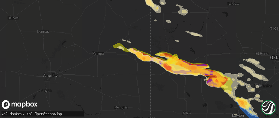
Hail Map in Wheeler, TX on May 9, 2026
The weather event in Wheeler, TX on May 9, 2026 includes Wind, Hail, and Tornado maps. 12 states and 235 cities were impacted and suffered possible damage. The total estimated number of properties impacted is 228.
Wind
Hail
Tornado
228
Estimated number of impacted properties by a 1.00" hail or larger200
Estimated number of impacted properties by a 1.75" hail or larger71
Estimated number of impacted properties by a 2.50" hail or largerStorm reports in Wheeler, TX
Wheeler, TX
| Date | Description |
|---|---|
| 05/09/20266:48 PM CDT | Tennis ball size hail reported 1 mile east of the intersection of highways 152 and 592 along highway 152. |
| 05/09/20266:41 PM CDT | Report of golf ball size hail eat of wheeler along tx highway 152. |
| 05/09/20266:41 PM CDT | Report near intersection of county road 22 and highway 152. |
| 05/09/20266:30 PM CDT | Golf ball size hail reported near intersection of county road 18 and county road j. |
All States Impacted by Hail Map on May 9, 2026
All Cities Impacted by Hail Map on May 9, 2026
- Roma, TX
- Carriere, MS
- Picayune, MS
- Rio Grande City, TX
- Kiln, MS
- Perkinston, MS
- Mcallen, TX
- Pharr, TX
- Alamo, TX
- Donna, TX
- San Juan, TX
- San Benito, TX
- Los Fresnos, TX
- Port Isabel, TX
- South Padre Island, TX
- Clarkston, MI
- Austin, TX
- Pflugerville, TX
- Manor, TX
- Bunnell, FL
- Rawlins, WY
- Burkeville, TX
- Wiergate, TX
- Hanna, WY
- Newton, TX
- Edgewater, FL
- Oak Hill, FL
- New Smyrna Beach, FL
- Fayetteville, TX
- Sweetwater, OK
- Hemphill, TX
- Sayre, OK
- Cheyenne, OK
- Elk City, OK
- Miami, TX
- Canadian, TX
- Mobeetie, TX
- Colmesneil, TX
- Canute, OK
- Wheeler, TX
- Briscoe, TX
- Pine Bluffs, WY
- Bushnell, NE
- Saint Francis, KS
- Wray, CO
- Bosler, WY
- Foss, OK
- Kimball, NE
- New Raymer, CO
- Cordell, OK
- Dill City, OK
- Lewisville, AR
- Woodville, TX
- East Aurora, NY
- Stoneham, CO
- Bessie, OK
- Corn, OK
- Sour Lake, TX
- Katy, TX
- Richmond, TX
- Goodland, KS
- Cheyenne, WY
- Edson, KS
- Grover, CO
- Carpenter, WY
- Balko, OK
- Houston, TX
- Warren, TX
- Hillister, TX
- Hereford, CO
- Briggsdale, CO
- Liberty, TX
- Laverne, OK
- Sterling, CO
- Bradley, AR
- Sentinel, OK
- Follett, TX
- Shattuck, OK
- Colby, KS
- Merino, CO
- Atwood, CO
- Buffalo, OK
- Fargo, OK
- Erick, OK
- Freedom, OK
- Rocky, OK
- May, OK
- Gotebo, OK
- Otis, CO
- Akron, CO
- Hobart, OK
- Woodward, OK
- Gage, OK
- Fort Supply, OK
- Alva, OK
- Mountain View, OK
- Carnegie, OK
- Arnett, OK
- Carter, OK
- Sharon, OK
- Wallisville, TX
- Dayton, TX
- Fort Cobb, OK
- Yuma, CO
- Vici, OK
- Gracemont, OK
- Anadarko, OK
- Apache, OK
- Waynoka, OK
- Aline, OK
- Dacoma, OK
- Carmen, OK
- Cope, CO
- Joes, CO
- Eckley, CO
- Fletcher, OK
- Buffalo, NY
- Clarence, NY
- Bowmansville, NY
- Lancaster, NY
- Depew, NY
- Alden, NY
- Akron, NY
- Corfu, NY
- Batavia, NY
- East Pembroke, NY
- Alexander, NY
- Elgin, OK
- Delco, NC
- Riegelwood, NC
- Cement, OK
- Kirk, CO
- Vona, CO
- Vernon, CO
- Stratton, CO
- Idalia, CO
- Rosenberg, TX
- Ninnekah, OK
- Deer Trail, CO
- Lawton, OK
- Burlington, CO
- Bethune, CO
- Kiowa, CO
- Marlow, OK
- Leedey, OK
- Duncan, OK
- Cheyenne Wells, CO
- Cyril, OK
- Geronimo, OK
- Custer City, OK
- Butler, OK
- Taloga, OK
- Comanche, OK
- Walters, OK
- Waurika, OK
- Kanorado, KS
- Weskan, KS
- Arapahoe, CO
- Ringling, OK
- Loco, OK
- Hammon, OK
- Chickasha, OK
- Wilson, OK
- Rush Springs, OK
- Bokoshe, OK
- Keota, OK
- Whitesboro, TX
- Sadler, TX
- Hendrix, OK
- Colbert, OK
- Lookeba, OK
- Denison, TX
- Sherman, TX
- Pottsboro, TX
- Minco, OK
- Binger, OK
- Spiro, OK
- Pocasset, OK
- Bells, TX
- Savoy, TX
- Muldrow, OK
- Gans, OK
- Telephone, TX
- Amber, OK
- Hinton, OK
- Ravenna, TX
- Dodd City, TX
- Windom, TX
- Honey Grove, TX
- Calumet, OK
- Bonham, TX
- Paris, TX
- Union City, OK
- El Reno, OK
- Blossom, TX
- Petty, TX
- Brookston, TX
- Sallisaw, OK
- Roxton, TX
- Pattonville, TX
- Howe, TX
- Deport, TX
- Detroit, TX
- Cooper, TX
- Pecan Gap, TX
- Gainesville, TX
- Lake Creek, TX
- Clarksville, TX
- Sulphur Bluff, TX
- Talco, TX
- Valley View, TX
- Avery, TX
- Collinsville, TX
- Tioga, TX
- Annona, TX
- Pilot Point, TX
- De Kalb, TX
- Tuttle, OK
- Blanchard, OK
- Aubrey, TX
- Celina, TX
- Little Elm, TX
- Purcell, OK
- Washington, OK
- Cartwright, OK
- Gruver, TX
- Yukon, OK
- Guymon, OK
- Booker, TX
- Hardesty, OK
- Kingston, OK
- Tom Bean, TX
- Whitewright, TX
- Spearman, TX
- Van Alstyne, TX


