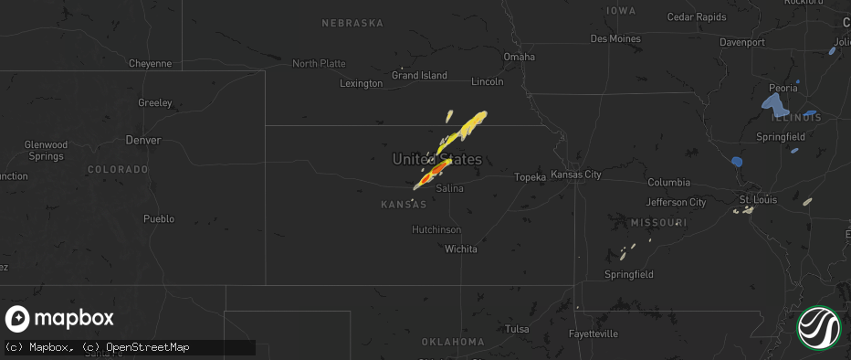
Hail Map on May 18, 2026
The weather event on May 18, 2026 includes Wind, Hail, and Tornado maps. 19 states and 1,691 cities were impacted and suffered possible damage. The total estimated number of properties impacted is 136,795.
Wind
Hail
Tornado
136,795
Estimated number of impacted properties by a 1.00" hail or larger28,298
Estimated number of impacted properties by a 1.75" hail or larger447
Estimated number of impacted properties by a 2.50" hail or largerStates Impacted by Hail Map on May 18, 2026
Storm reports
Oklahoma
| Date | Description |
|---|---|
| 05/18/20266:30 PM CDT | Putnam mesonet. |
| 05/18/20266:01 PM CDT | A local report indicates 1.25 inch wind near 1 W Elk City |
| 05/18/20265:59 PM CDT | A local report indicates 1.00 inch wind near 1 SW Elk City |
| 05/18/20265:25 PM CDT | A local report indicates 1.25 inch wind near 1 SE Mangum |
| 05/18/20261:05 AM CDT | A local report indicates 71 MPH wind near 8 E Newkirk |
| 05/18/20261:01 AM CDT | Report from mping: half dollar |
| 05/18/20261:00 AM CDT | Power lines and trees blown down. Time estimated by radar. |
| 05/18/202612:45 AM CDT | Power lines down at peckham road and w street. Time estimated from radar. |
Iowa
| Date | Description |
|---|---|
| 05/18/20266:56 PM CDT | Emergency manager confirms tornado on the ground. Time estimated via radar. |
| 05/18/20266:40 PM CDT | Trained spotter confirms tornado. Time estimated via radar. |
| 05/18/20266:30 PM CDT | Trained spotter confirms tornado. Time estimated via radar. |
| 05/18/20265:57 PM CDT | Report from mping: quarter |
| 05/18/20265:51 PM CDT | Report from mping: quarter |
| 05/18/20265:51 PM CDT | A local report indicates 1.00 inch wind near Clarinda |
| 05/18/20265:47 PM CDT | Personal weather station. |
| 05/18/20265:36 PM CDT | Time is estimated. |
| 05/18/20265:35 PM CDT | Picture via social media. |
| 05/18/20265:26 PM CDT | Picture via social media. |
| 05/18/20265:23 PM CDT | Social media picture. |
| 05/18/20265:04 PM CDT | Ping pong ball size hail reported south of farragut. |
| 05/18/20265:00 PM CDT | A local report indicates 1.00 inch wind near Chatsworth |
| 05/17/20267:09 PM CDT | Multiple reports from emergency management of confirmed tornado. |
Michigan
| Date | Description |
|---|---|
| 05/18/20264:27 PM CDT | Social media photo of healthy tree snapped |
| 05/18/20264:23 PM CDT | Report of trees down near 22 mi and schoenherr rd and 23 mi and schoenherr rd |
| 05/18/20264:19 PM CDT | Report of tree down on power line |
| 05/18/20264:19 PM CDT | Report of a large tree down on house and car |
| 05/18/20264:12 PM CDT | Large tree limb and powerlines down. |
| 05/18/20264:00 PM CDT | Social media photo of a healthy tree snapped |
| 05/18/20263:54 PM CDT | Social media photos of large tree limb down and small tree snapped |
| 05/18/20263:52 PM CDT | Photo of healthy tree snapped near base |
| 05/18/20263:50 PM CDT | Report of 3ft diameter pine tree down |
| 05/18/20263:45 PM CDT | Measured at kptk pontiac airport |
| 05/18/20263:35 PM CDT | Large tree limb down. |
| 05/18/20263:35 PM CDT | Reports of trees and wires down in the county... Especially across northern sections of the county. |
| 05/18/20263:26 PM CDT | Report of 10 to 12 inch tree limbs down |
| 05/18/20263:24 PM CDT | Report of a tree down |
| 05/18/20263:24 PM CDT | Report of a large tree on home |
| 05/18/20263:21 PM CDT | Mulitple large limbs and powerlines down. |
| 05/18/20263:18 PM CDT | Large tree limbs down on powerlines. |
| 05/18/20263:18 PM CDT | Report of multiple trees down near harry brown airport |
| 05/18/20263:17 PM CDT | Measured on a handheld anemometer |
| 05/18/20263:17 PM CDT | County dispatch reports tree down. Time estimated via radar. |
| 05/18/20263:16 PM CDT | Measured at khyx - harry browne airport |
| 05/18/20263:12 PM CDT | Measured at kmbs - mbs international airport |
| 05/18/20263:05 PM CDT | Report of multiple power lines down |
| 05/18/20263:03 PM CDT | Photo of a healthy tree down across road. Estimated 1 ft diameter. |
| 05/18/20263:00 PM CDT | 24 inch diameter healthy tree down |
| 05/18/20262:56 PM CDT | Multiple trees on lines by river rd and shepherd rd. |
| 05/18/20262:50 PM CDT | County dispatch reports numerous trees and wires down across south/southeastern part of county. Time estimated via radar. |
| 05/18/20262:40 PM CDT | Metal rooftop lifted off a body shop building. Also a tree uprooted onto a house in st louis. |
| 05/18/20262:40 PM CDT | County dispatch reports numerous trees and wires down across the county. Time estimated via radar. |
| 05/18/20262:35 PM CDT | Emergency management reports numerous trees and wires down across the county. More concentrated damage across the st louis and pompei areas. Time estimated via radar. |
| 05/18/20262:35 PM CDT | County dispatch reports a barn received significant damage. Time estimated via radar. |
| 05/18/20262:34 PM CDT | Photos show pole barn roof torn off and moved approx 60 yards. Time estimated via radar. |
| 05/18/20262:33 PM CDT | Awos station kamn gratiot community airport. |
| 05/18/20262:30 PM CDT | Measured by personal weather station. Sustained 61 gust 81 mph from approx 190 degree direction. Scattered power outages in the area. |
| 05/18/20262:28 PM CDT | Sporadic trees reported down across the entire county... But particularly in and around adrian. |
| 05/18/20262:25 PM CDT | Three small planes damaged at lansing capital region international airport. Two parked planes were flipped on their side... While one plane was being towed and got flip |
| 05/18/20262:25 PM CDT | Asos station klan lansing. |
| 05/18/20262:25 PM CDT | County dispatch reports numerous trees and wires down across the county... Especially in st. Johns. Time estimated via radar. |
| 05/18/20262:24 PM CDT | Report of large tree limb down on house causing damage to roofing |
| 05/18/20262:23 PM CDT | County dispatch reports numerous trees and wires down across the county including multiple trees on houses. Time estimated via radar. |
| 05/18/20262:19 PM CDT | County dispatch reports numerous trees and wires down across the county. Time estimated via radar. |
| 05/18/20262:19 PM CDT | Cou |
| 05/18/20262:10 PM CDT | Maple tree down and golf cart turned over. |
| 05/18/20262:03 PM CDT | One foot healthy diameter tree down. |
| 05/18/20262:03 PM CDT | County dispatch reports numerous trees and wires down across the county. Time estimated via radar. |
| 05/18/20262:03 PM CDT | Public report of a barn with significant damage near portland. Time estimated via radar. |
| 05/18/20262:01 PM CDT | Roof mounted weather station peak gust. Heavy damage to trees. |
| 05/18/20262:00 PM CDT | Ionia county awos. |
| 05/18/20261:59 PM CDT | County dispatch reports numerous trees and wires down across the county. Time estimated via radar. |
| 05/18/20261:53 PM CDT | 911 dispatch reports numerous trees and wires down across calhoun county including a tree on a house in marshall. Time estimated via radar. |
| 05/18/20261:51 PM CDT | Two trees down by 11 mile rd and young ave. Time approximate. |
| 05/18/20261:50 PM CDT | Estimated winds to 70 mph and some flooding. Reported near correll road and colon road. Time estimated from radar. |
| 05/18/20261:50 PM CDT | Widespread small and medium limb damage. |
| 05/18/20261:50 PM CDT | A local report indicates 59 MPH wind near 1 ENE Woodland |
| 05/18/20261:49 PM CDT | Damage to a roof at a learning center. Time approximate. |
| 05/18/20261:47 PM CDT | Numerous trees down blocking roads between caledonia and lowell... Including peck lake rd at kyser and catch rds. |
| 05/18/20261:45 PM CDT | Mesonet recorded gust. |
| 05/18/20261:44 PM CDT | Battle creek asos. |
| 05/18/20261:42 PM CDT | Gerald r ford international airport asos. |
| 05/18/20261:36 PM CDT | County dispatch reports numerous trees and wires down across the county. Time estimated via radar. |
| 05/18/20261:36 PM CDT | County dispatch reports numerous trees and wires down across the county. Time estimated via radar. |
| 05/18/20261:35 PM CDT | Corrects time of previous tstm wnd dmg report from 4 ne constantine. Emergency manager reports powerlines and power pole down near freese road and roys road to the nort |
| 05/18/20261:34 PM CDT | Tree on house. |
| 05/18/20261:25 PM CDT | Power lines down in florence township. Time estimated from radar. |
| 05/18/20261:20 PM CDT | Reporter also notes numerous downed tree limbs. Time estimated via radar. |
| 05/18/20261:20 PM CDT | Kalamazoo asos. |
| 05/18/20261:19 PM CDT | Large tree branches down near corey lake. Time estimated from radar. |
| 05/18/20261:18 PM CDT | Reports via mping of several tree limbs snapped... Some wires down... And a broken power pole. |
| 05/18/20261:12 PM CDT | Multiple large healthy trees down. Time approximate. |
| 05/18/20261:10 PM CDT | Power out with quite a few branches down. Location approximate. |
| 05/18/20261:10 PM CDT | 911 dispatch reports numerous trees and wires down across southern ottawa county. Time estimated via radar. |
| 05/18/20261:04 PM CDT | Reports of trees downed. Time estimated from radar. |
| 05/18/20261:04 PM CDT | Reports of trees downed. Time estimated from radar. |
| 05/18/20261:01 PM CDT | Tree down across 44th st by 6th ave. |
| 05/18/20261:01 PM CDT | Emergency management and county dispatch report numerous trees and wires down across allegan county. Time estimated via radar. |
| 05/18/20261:00 PM CDT | Large trees downed in vandalia area. Time estimated from radar. |
| 05/18/202612:54 PM CDT | 911 dispatch reports numerous trees and wires down across van buren county. Time estimated via radar. |
| 05/18/202612:50 PM CDT | Damage reported at the edwardsburg little league fields. Two dugout roofs were blown off... Several fences damaged... And some damage to the bleachers. Time estimated v |
| 05/18/202612:48 PM CDT | Large tree downed onto eagle lake road. Time estimated from radar. |
| 05/18/202612:46 PM CDT | Irrigation pivot flipped over. Time estimated from radar. |
| 05/18/202612:41 PM CDT | Mdot station mc099 at south haven. |
| 05/18/202612:35 PM CDT | Emergency manager reports powerlines and power pole down near freese road and roys road to the northeast of constantine in st. Joseph county in michigan. Time estimated |
| 05/18/202612:34 PM CDT | Delayed report. Large tree limbs downed on ferry street. Time estimated from radar. |
| 05/18/202612:25 PM CDT | Asos station kbeh benton harbor. |
Maryland
| Date | Description |
|---|---|
| 05/18/20264:16 PM CDT | Multiple trees down on high germany road and bottenfield road. |
Texas
| Date | Description |
|---|---|
| 05/18/20261:01 AM CDT | Public report/picture via facebook of a large tree downed in front of freer high school. Time estimated using radar. |
West Virginia
| Date | Description |
|---|---|
| 05/18/20265:21 PM CDT | County 911 reports a couple of trees down on 130th block of energy drive... And 440th block of trimble ave. Time estimated from radar. |
| 05/18/20265:11 PM CDT | County 911 reports downed tree near intersection of shireoaks drive and lost road. |
| 05/18/20263:31 PM CDT | Public reports quarter size hail in baker... Wv. Time estimated from radar. |
| 05/17/202610:08 PM CDT | Tree down near the intersection of appalachian highway and northridge road. Time estimated from radar. |
Indiana
| Date | Description |
|---|---|
| 05/18/20266:54 PM CDT | Reports of trees down along north franklin bottoms rd. |
| 05/18/20266:50 PM CDT | Tree down on residential property on cedarwood dr. |
| 05/18/20266:40 PM CDT | Tree and power lines downed on state route 148. |
| 05/18/20266:39 PM CDT | Trees down on east blue river road. |
| 05/18/20266:31 PM CDT | Report of trees down near the intersection of sr 160 and s casey rd west of henryville... In. |
| 05/18/20266:11 PM CDT | Large tree in the roadway... Blocking the entire road. Chain saws needed. |
| 05/18/20266:10 PM CDT | Reports of several trees down along state road 160 near the intersections of s franklin school road and s conway church road. |
| 05/18/20266:00 PM CDT | Tree on power line on 22000 block of campbell str. |
| 05/18/20266:00 PM CDT | Tree on power line on speith rd. |
| 05/18/20265:50 PM CDT | Trees down around the county and along sr 160 near salem. One tree fell on a vehicle on carolyn dr. But no injuries were reported. |
| 05/18/20265:00 PM CDT | Several trees down in the roadway. |
| 05/18/20264:45 PM CDT | Large tree blocking roadway. |
| 05/18/20263:59 PM CDT | Delayed report. Trees and power lines down over mount pleasant road to the east of darmstadt road. |
| 05/18/20262:22 PM CDT | Emergency manager report of tree downed across roadway on cr 800e just south of us-20 just north of metz in steuben county in indiana. Time is estimated by radar. |
| 05/18/20262:15 PM CDT | Emergency manager report of powerlines downed in hamilton in steuben county in indiana. Time is estimated by radar. |
| 05/18/20261:47 PM CDT | Delayed report. Power lines down. Report from social media. |
| 05/18/20261:47 PM CDT | Emergency manager report of tree blown down across ruckman road near old trail road about 6 miles east of columbia city in whitley county in indiana. Time estimated by |
| 05/18/20261:45 PM CDT | 60 mph winds reported at the huntington county ema office. Time estimated via radar. |
| 05/18/20261:45 PM CDT | Spotter reports measured thunderstorm wind gust of 61 mph just southwest of blue lake in whitley county in indiana. |
| 05/18/20261:35 PM CDT | Indianapolis executive airport measured a wind gust of 61 mph. |
| 05/18/20261:29 PM CDT | Mping report of trees damaged by wind estimated at 60 mph. |
| 05/18/20261:25 PM CDT | Tree down on n 1150 w at stone lake north of middlebury. Time estimated via radar. |
| 05/18/20261:19 PM CDT | Large tree limbs downed on north maple street. Time estimated from radar. |
| 05/18/20261:18 PM CDT | Several trees and powerlines down in the county. |
| 05/18/20261:16 PM CDT | Large tree downed onto a house on west main street. Time estimated from radar. |
| 05/18/20261:13 PM CDT | Large tree branches downed near ferry and anna streets. Time estimated from radar. |
| 05/18/202612:50 PM CDT | Large tree downed. Time estimated from radar. |
| 05/18/202612:50 PM CDT | Powerlines down near the intersection of ash rd and jefferson rd. Time estimated via radar. |
| 05/18/202612:50 PM CDT | Outbuilding damaged north of mentone on sr 19. Time estimated via radar. |
| 05/18/202612:45 PM CDT | Significant number of trees and powerlines downed in the county. |
| 05/18/202612:43 PM CDT | Large tree downed on hickory road. Time estimated from radar. |
| 05/18/202612:43 PM CDT | Multiple trees downed near intersection of grape and brick road. Time estimated from radar. |
| 05/18/202612:43 PM CDT | Media reported a large tree snapped along with other branches near osceola in st. Joseph county indiana. Time is radar estimated. |
| 05/18/202612:40 PM CDT | Large tree down on quail ridge south. Time estimated from radar. |
| 05/18/202612:40 PM CDT | Large branches downed. Time estimated from radar. |
| 05/18/202612:38 PM CDT | Large tree branches downed. Time estimated from radar. |
| 05/18/202612:37 PM CDT | Media reported large branch down near granger in st. Joseph county in indiana. Time estimated by radar. |
| 05/18/202612:36 PM CDT | Photon facebook showing a large tree uprooted |
| 05/18/202612:34 PM CDT | Large tree branches downed near gumwood and brock road. Time estimated by radar. |
| 05/18/202612:34 PM CDT | Large tree downed by thunderstorm wind gusts. Delayed report. Time estimated from radar. |
| 05/18/202612:31 PM CDT | Media report of a large tree downed onto a vehicle by a thunderstorm wind gust near intersection of humboldt street and cleveland avenue in south bend... In st. Joseph |
| 05/18/202612:31 PM CDT | Large trees branches downed near eddy st. And jefferson blvd. Time estimated from radar. |
| 05/18/202612:31 PM CDT | Large tree downed on notre dame campus. Time estimate from radar. |
| 05/18/202612:31 PM CDT | Pictures relayed by ema of a pole barn suffering damage to several walls and the roof as well as a tree down in the area. Location along w 100 s... Between s 200 and s |
| 05/18/202612:23 PM CDT | Three power poles downed by thunderstorm wind gusts. |
| 05/18/202612:18 PM CDT | Tree downed by thunderstorm wind gusts. |
| 05/18/202612:16 PM CDT | Media report of large tree snapped in half near new carlisle in st. Joseph county in indiana. Time estimated by radar. |
| 05/18/202612:15 PM CDT | Tree downed by thunderstorm wind gusts. |
| 05/18/202612:15 PM CDT | Powerlines downed by thunderstorm wind gusts. |
| 05/18/202612:07 PM CDT | Large tree branches downed. Time estimated from radar. |
| 05/18/202612:05 PM CDT | Several reports of trees down in la porte in vicinity and heading into la porte... In on us route 35. Time estimated from radar. |
| 05/18/202612:00 PM CDT | Tree down across long lane and us 6 near union mills. Time estimated via radar. |
| 05/18/202611:45 AM CDT | Photo on facebook shows damage to walls and roof of a barn in wanatah. Time estimated via radar. |
| 05/18/202611:45 AM CDT | Emergency manager reports several trees and large branches downed including a couple large limbs down onto houses. No injuries reported. Time estimated by radar. |
| 05/18/202611:40 AM CDT | Private weather station 1.5 miles north of kouts reported 60 mph gust. |
| 05/18/202611:29 AM CDT | Public report of 1.0 inch hail east of winfield. Time estimated by radar. |
| 05/18/202611:21 AM CDT | Corrects previous report from 1 sse hobart to tstm wind. Public report of 65 mph gust recorded by backyard weather station near linda street and 10th street in hobart. |
| 05/18/202611:21 AM CDT | Public report of 65 mph gust recorded by backyard weather station near linda street and 10th street in hobart. Time estimated by radar. |
| 05/18/202611:13 AM CDT | Gary airport awos gyy reported 58 mph wind gust from the south. |
| 05/18/202611:13 AM CDT | Gary airport asos gys reported 58 mph wind gust from the south. |
| 05/17/20267:05 PM CDT | Reports of trees down along s eastern school rd... Nne of new pekin... In. |
Missouri
| Date | Description |
|---|---|
| 05/18/20266:48 PM CDT | Downed wires near route u. Time confirmed from radar. |
| 05/18/20266:21 PM CDT | Downed wires near cooper street. Time estimated from radar. |
| 05/18/20266:18 PM CDT | Mo sema employee reported ping pong ball size hail. |
| 05/18/20266:17 PM CDT | Social media report. Time estimated from radar. |
| 05/18/20265:58 PM CDT | Em relayed spotter reported golf ball sized hail. |
| 05/18/20265:05 PM CDT | Public relayed 60 mph winds with initial storms moving through. Time estimated from radar. |
| 05/18/20265:05 PM CDT | Pws measured multiple wind gusts over 60 mph... Including peak 75 mph. |
| 05/18/20263:47 PM CDT | A large section of a home was blown in. Multiple trees were uprooted. |
| 05/18/20267:38 AM CDT | Relayed from social media: tree blocking highway 47 at big creek north of warrenton. Time estimated from radar. |
| 05/17/202611:21 PM CDT | Report relayed from social media... Destroyed outbuilding in windsor. Time estimated from radar. |
| 05/17/202610:36 PM CDT | Social media video of power flashes and downed power lines in carrollton. Time estimated from radar. |
| 05/17/202610:30 PM CDT | Downed wires near county road 623. Time estimated from radar. |
| 05/17/202610:28 PM CDT | Downed wires and power outages near county road 201. Time estimated from radar. |
| 05/17/202610:19 PM CDT | Wires down near route t. Time estimated from radar. |
| 05/17/202610:16 PM CDT | Several reports of downed wires and widespread power outages between hamilton and breckenridge. Time estimated from radar. |
| 05/17/202610:10 PM CDT | Social media report relayed of trees down... Time estimated from radar. |
| 05/17/202610:07 PM CDT | Reports of downed wires east of pleasant hill. Time estimated from radar. |
| 05/17/202610:04 PM CDT | Several large trees or limbs downed north of oak grove. Time estimated from radar. |
| 05/17/202610:04 PM CDT | Downed trees and power poles near and north of richmond. Time estimated from radar. |
| 05/17/202610:01 PM CDT | Downed tree at a residence southwest of richmond. Time estimated from radar. |
| 05/17/202610:00 PM CDT | Carport blown into a tree and downed limbs at a residence in odessa. Time estimated from radar. |
| 05/17/20269:53 PM CDT | Nws employee reported tree snapped and fallen. Time estimated from radar. |
| 05/17/20269:52 PM CDT | Tds observed on radar at 9:52 pm cdt. |
| 05/17/20269:52 PM CDT | Nws employee reported multiple 4-6 inch diameter limbs down across the local area. Time estimated from radar. |
| 05/17/20269:51 PM CDT | Large tree down at a residence west of buckner. Time estimated from radar. |
| 05/17/20269:51 PM CDT | Two large tree limbs downed at a residence. Time estimated from radar. |
| 05/17/20269:49 PM CDT | Lees summit municipal airport measured a 58 mph wind gust. |
| 05/17/20269:49 PM CDT | Report of tree branches snapped... Time estimated from radar. |
| 05/17/20269:49 PM CDT | Photo shared via social media of a tree blown over... Time estimated from radar. |
| 05/17/20269:49 PM CDT | Photo relayed via social media of large tree branches broken off... Time estimated from radar. |
| 05/17/20269:48 PM CDT | Photo relayed via social media of large tree branches down. Time estimated from radar/cross referenced with post. |
| 05/17/20269:47 PM CDT | Nws damage survey team confirmed an ef1 tornado occured monday evening... 5/18/2026... Beginning at 9:47 pm cdt in southwestern ray county missouri. This tornado caused |
| 05/17/20269:46 PM CDT | Shared photos of damage to trees and fences... Time estimated from radar. |
| 05/17/20269:46 PM CDT | Downed trees near garnes and white oak. Time estimated from radar. |
| 05/17/20269:46 PM CDT | Photo relayed via social media of tree tops broken off trees. Time estimated from radar. |
| 05/17/20269:46 PM CDT | Large tree limbs down and a fence blown over. Winds estimated at 80 mph. Time estimated from radar. |
| 05/17/20269:45 PM CDT | Pws measured 66 mph wind gust. |
| 05/17/20269:43 PM CDT | Photos relayed via social media of large tree branches down... Time estimated from radar. |
| 05/17/20269:43 PM CDT | Multiple social media reports of trees down in independence. Time estimated from radar. |
| 05/17/20269:40 PM CDT | Large tree downed near 84th and laurel. Time estimated from radar. |
| 05/17/20269:40 PM CDT | Downed tree and wires near old state highway 210. Time estimated from radar. |
| 05/17/20269:38 PM CDT | Report relayed via social media of power line down due to large tree branch snapping... Time estimated from radar. |
| 05/17/20269:37 PM CDT | Photo relayed via social media of a large tree branch down. Time estimated from radar. |
| 05/17/20269:37 PM CDT | Report relayed via social media of multiple downed trees/tree limbs. Time estimated from radar. |
| 05/17/20269:37 PM CDT | Large tree down on truman road east of i-435. Time estimated from radar. |
| 05/17/20269:36 PM CDT | Photo relayed via social media of a large tree branch down. Time estimated from radar. |
| 05/17/20269:36 PM CDT | Law enforcement measured a 63 mph wind gust. |
| 05/17/20269:35 PM CDT | Social media report. Snapped tree on 39th street. Time estimated from radar. |
| 05/17/20269:35 PM CDT | Downed trees and limbs west of i-35 and route 291. Time estimated from radar. |
| 05/17/20269:35 PM CDT | Tree partially over stadium drive. |
| 05/17/20269:35 PM CDT | Several trees down near 44th street. Time estimated from radar. |
| 05/17/20269:35 PM CDT | Downed wires near cambridge avenue. Time estimated from radar. |
| 05/17/20269:34 PM CDT | Social media relayed report of downed trees. Time estimated from radar. |
| 05/17/20269:32 PM CDT | Blown transformer and power lines down in gladstone. Time estimated from radar. |
| 05/17/20269:32 PM CDT | Several reports of downed tree limbs and wires near hardesty avenue. Time estimated from radar. |
| 05/17/20269:30 PM CDT | Pws measured 59 mph wind gust. |
| 05/17/20269:30 PM CDT | Downed tree and wires near bienheim park. Time estimated from radar. |
| 05/17/20269:30 PM CDT | Downed tree branch on overheard wires of streetcar... Suspending service. Time estimated from radar. |
| 05/17/20269:29 PM CDT | Downed wires near sunnybrook lane. Time estimated from radar. |
| 05/17/20269:29 PM CDT | Several trees down... Including one through a house. Time estimated from radar. |
| 05/17/20269:29 PM CDT | Downtown kansas city ap measured 64 mph wind gusts. |
| 05/17/20269:29 PM CDT | Pws measured 65 mph wind gust. |
| 05/17/20269:27 PM CDT | Downed tree and limbs cherry street. Time confirmed from radar. |
| 05/17/20269:27 PM CDT | Report of 65 mph wind gust. |
| 05/17/20269:27 PM CDT | Photo relayed via social media of large tree uprooted with branches broken off... Time estimated from radar. |
| 05/17/20269:27 PM CDT | Downed tree relayed from social media. Time estimated from radar. |
| 05/17/20269:26 PM CDT | Large tree uprooted near 72nd terrace. Time estimated from radar. |
| 05/17/20269:26 PM CDT | Downed tree and wires near 65th terrace. Time confirmed from radar. |
| 05/17/20269:24 PM CDT | Em relayed public report of 70 mph wind gust. |
| 05/17/20269:24 PM CDT | Photo relayed via social media of tree branches snapped/trees down. Time estimated from radar. |
| 05/17/20269:24 PM CDT | Downed tree and wires near 86th street. Time confirmed from radar. |
| 05/17/20269:23 PM CDT | Downed wires near cerrito lane. Time estimated from radar. |
| 05/17/20269:18 PM CDT | Report of 60 mph gust relayed from em. |
| 05/17/20269:17 PM CDT | Multiple downed trees/limbs reported via social media. Time estimated from radar. |
| 05/17/20269:16 PM CDT | Photo shared via social media of large tree snapped at trunk... Time estimated from radar. |
| 05/17/20269:15 PM CDT | Downed tree limbs reported via social media. Time estimated from radar. |
| 05/17/20269:07 PM CDT | Measured from handheld anemometer. |
| 05/17/20269:01 PM CDT | Social media reports of downed tree limbs and wires near pattonsburg. Time estimated from radar. |
| 05/17/20268:55 PM CDT | Downed wires near elm road. Time estimated from radar. |
| 05/17/20268:48 PM CDT | Downed wires near lakesite road. Time estimated from radar. |
| 05/17/20268:46 PM CDT | Report of trees down and road closure. Photos shared show trees split down to trunks with large branches down... Minor structures blown over. Time estimated from radar. |
| 05/17/20268:43 PM CDT | Pws measured gust. |
| 05/17/20268:43 PM CDT | Report relayed via social media of downed trees and power lines. Time estimated from radar. |
| 05/17/20268:37 PM CDT | Several reports of downed tree limbs and wires in st. Joseph. Time estimated from radar. |
| 05/17/20268:37 PM CDT | Several reports of downed wires northwest of king city. Time estimated from radar. |
| 05/17/20268:37 PM CDT | Social media report of a barn roof blown off. Time estimated from radar. |
| 05/17/20268:33 PM CDT | Pws measured 65 mph gust. |
| 05/17/20268:31 PM CDT | Pws measured 58 mph gust. |
| 05/17/20268:22 PM CDT | Downed trees and wires in bolckow. Time estimated from radar. |
| 05/17/20268:22 PM CDT | Several reports of downed trees and wires and property damage on county road 191. Time estimated from radar. |
| 05/17/20268:20 PM CDT | Photos relayed of trees limbs down/uprooted trees. Time estimated from radar. |
| 05/17/20268:19 PM CDT | Relayed social media report of multiple trees down. Time estimated from radar. |
| 05/17/20268:16 PM CDT | Social media relayed a report of a downed tree damaging a vehicle. Time estimated from radar. |
| 05/17/20268:14 PM CDT | Social media relayed photos of large tree branches down... Time estimated from radar. |
| 05/17/20268:14 PM CDT | Photos relayed of large tree branches down/snapped at trunks. Time estimated from radar. |
| 05/17/20268:14 PM CDT | Several trees blown down in fillmore. Time estimated from radar. |
| 05/17/20268:13 PM CDT | Kstj asos recorded 61 mph wind gust. |
| 05/17/20268:12 PM CDT | Photos relayed of large tree branches down/trees snapped at trunks. Time estimated from radar. |
| 05/17/20268:05 PM CDT | Downed wires and power outages near riverbreaks conservation area. Time estimated from radar. |
| 05/17/20267:29 PM CDT | Report from mping: quarter |
| 05/17/20267:13 PM CDT | Multiple reports of a tornado southwest of grant city from the public and from an emergency manager. No known reports of damage at this time. Time and location approxim |
| 05/17/20267:08 PM CDT | Multiple reports of downed wires west of fairfax. Time estimated from radar. |
| 05/17/20267:01 PM CDT | Hail up to ping pong in size. |
| 05/17/20267:00 PM CDT | Em relayed pictures of hail next to ruler. Largest greater than 2.5 inches in diameter. |
Virginia
| Date | Description |
|---|---|
| 05/18/20264:48 PM CDT | City of winchester em reported trees and wires down at intersection of brick kiln rd and smithfield ave. Time estimated from radar. |
| 05/18/20264:20 PM CDT | County 911 reports tree down onto the roadway at the 400th block of fishel ave. Time estimated from radar. |
| 05/18/20264:20 PM CDT | Tree down on fishel road near back mountain road. |
| 05/18/20264:10 PM CDT | Mping report of 1 inch hail |
| 05/17/20268:31 PM CDT | Tree fell on trailer. |
Ohio
| Date | Description |
|---|---|
| 05/18/20264:04 PM CDT | Tree limb on transformer. Time estimated via radar. |
| 05/18/20263:45 PM CDT | Power lines blown down near south centennial road and cr 30 in the holland area. Report from social media. |
| 05/18/20263:42 PM CDT | Power lines down near reed road and south berkey southern road. |
Nebraska
| Date | Description |
|---|---|
| 05/18/20266:40 PM CDT | Mix of dimes with a few quarters. |
| 05/18/20266:30 PM CDT | Report from mping: ping pong ball |
| 05/18/20266:21 PM CDT | A local report indicates 1.00 inch wind near 5 NNW Valparaiso |
| 05/18/20266:19 PM CDT | Public report of half dollar size hail. |
| 05/18/20266:15 PM CDT | Rainfall so far this evening has only been 0.25 inch... But the sky looked like heavier and hail fell to the southeast closer to ponca. |
| 05/18/20266:12 PM CDT | Trained spotter reported half dollar size hail. |
| 05/18/20266:10 PM CDT | Some quarter sized hail stones... But mostly dime sized. Heavy rain... No wind... And no damage. |
| 05/18/20266:02 PM CDT | A local report indicates 1.50 inch wind near Allen |
| 05/18/20265:52 PM CDT | Report from mping: quarter |
| 05/18/20265:50 PM CDT | A local report indicates 1.00 inch wind near 1 E Wayne |
| 05/18/20265:46 PM CDT | Report relayed by nws employee via nwschat. |
| 05/18/20265:39 PM CDT | Mix of peas and quarters. |
| 05/18/20265:30 PM CDT | Dime to golf ball size hail. |
| 05/18/20265:15 PM CDT | Multi-vortex tornado reported north of falls city. |
| 05/18/20265:08 PM CDT | Report from mping: ping pong ball |
| 05/18/20265:04 PM CDT | Trained spotter reported golf ball sized hail 7.5 miles south of friend. |
| 05/18/20265:00 PM CDT | Photo of a cone tornado ongoing south of dawson. |
| 05/18/20264:52 PM CDT | A local report indicates 1.75 inch wind near Milligan |
| 05/18/20264:45 PM CDT | Report of multi-vortex tornado east of hwy 99 and hwy 8. |
| 05/18/20264:45 PM CDT | Personal weather station. |
| 05/18/20264:43 PM CDT | Public report of golf ball size hail north of auburn. Location and time are estimated from radar. |
| 05/18/20264:40 PM CDT | A local report indicates 1.00 inch wind near Strang |
| 05/18/20264:34 PM CDT | Personal weather station gusted to 62 mph. |
| 05/18/20264:27 PM CDT | Reports of extensive damage in auburn. Possible people trapped in homes. Possible tornado damage. Time is estimated. |
| 05/18/20264:27 PM CDT | Video from broadcast media showed a small... Rain-wrapped tornado moving generally eastward just south of road 733a and highway 75. Damage consisted of a small cluster |
| 05/18/20264:26 PM CDT | Hail the size of quarters to ping pong balls... Most were smaller. |
| 05/18/20264:20 PM CDT | A tornado developed just south of highway 136 and west of 636 avenue... And moved east northeast to the area near highway 136 and just east of 637 avenue. This tornado |
| 05/18/20264:12 PM CDT | Corrects previous tstm wnd gst report from 5 ssw johnson. Personal weather station. |
| 05/18/20264:11 PM CDT | Report from mping: quarter |
| 05/18/20264:08 PM CDT | Downed trees... Damage to grain bins... And damaged farm outbuildings. Possible tornado damage. Time estimated from radar. |
| 05/18/20264:05 PM CDT | A tornado developed in open fields near the intersection of 625 avenue and 725 road... And moved quickly east. The tornado damaged many trees... Flipped pivots... And d |
| 05/18/20264:01 PM CDT | Lots of large tree limbs down. Time is estimated. |
| 05/18/20263:56 PM CDT | Personal weather station. |
| 05/18/20263:49 PM CDT | A local report indicates 1.75 inch wind near 4 N Clarkson |
| 05/18/20263:47 PM CDT | Caller reported an 81 mph wind gust measured from a personal weather station. Also reported 6 to 8 inch diameter tree limbs broken. |
| 05/18/20263:27 PM CDT | Corrects previous non-tstm wnd gst report from 2 n blue springs. Personal weather station. |
| 05/18/20263:27 PM CDT | Spotter report driving on hwy 77 south toward beatrice. |
| 05/18/20263:22 PM CDT | Personal weather station gusted to 70 mph. |
| 05/18/20263:20 PM CDT | A local report indicates 1.00 inch wind near Beatrice |
| 05/18/20262:58 PM CDT | Wynmore fire dept. Reports tornado on the ground near odell. |
| 05/18/20262:48 PM CDT | Chaser stream of a brief cone tornado. |
| 05/17/20267:15 PM CDT | Report from mping: quarter |
Kansas
| Date | Description |
|---|---|
| 05/18/20266:49 PM CDT | Measured on a personal weather station. |
| 05/18/20266:47 PM CDT | A local report indicates 1.00 inch wind near Arlington |
| 05/18/20266:42 PM CDT | Report from mping: quarter |
| 05/18/20266:41 PM CDT | Personal weather station. |
| 05/18/20266:32 PM CDT | A local report indicates 2.00 inch wind near 7 ESE Inman |
| 05/18/20266:30 PM CDT | A local report indicates 1.50 inch wind near 2 WNW Hutchinson |
| 05/18/20266:29 PM CDT | A local report indicates 1.50 inch wind near 2 SW Inman |
| 05/18/20266:28 PM CDT | A local report indicates 67 MPH wind near 3 N Manhattan |
| 05/18/20266:23 PM CDT | Picture of a 6 foot diameter tree limb across leavenworth street. Time estimated from radar. |
| 05/18/20266:22 PM CDT | A local report indicates 65 MPH wind near Ogden |
| 05/18/20266:20 PM CDT | Twitter report. |
| 05/18/20266:20 PM CDT | A local report indicates 1.00 inch wind near Inman |
| 05/18/20266:17 PM CDT | Report from mping: quarter |
| 05/18/20266:17 PM CDT | A local report indicates 59 MPH wind near 7 WNW Haven |
| 05/18/20266:17 PM CDT | A local report indicates 63 MPH wind near 1 NW Moundridge |
| 05/18/20266:15 PM CDT | A local report indicates 1.00 inch wind near 1 NNE Hutchinson |
| 05/18/20266:10 PM CDT | Delayed report... Location and time estimated from radar. An 80 year old barn was completely destroyed near abbyville... With some other damage to various outbuildings. |
| 05/18/20266:10 PM CDT | Report from mping: quarter |
| 05/18/20266:00 PM CDT | Social media report of quarter-size hail. |
| 05/18/20266:00 PM CDT | Facebook report of large branches down in north hutchinson. |
| 05/18/20265:56 PM CDT | Public report estimated near 70 mph winds ahead of the main line of storms. |
| 05/18/20265:56 PM CDT | Public report estimated near 70 mph winds ahead of the ma |
| 05/18/20265:55 PM CDT | A local report indicates 70 MPH wind near 3 SSE Willowbrook |
| 05/18/20265:53 PM CDT | Storm chaser saw the tornado pass in front of them. They are seeing damage of grain bins in fields... Power lines down and tree damage. |
| 05/18/20265:53 PM CDT | 80 year old barn destroyed. |
| 05/18/20265:38 PM CDT | Damage reported by em of grain bins and trees. |
| 05/18/20265:38 PM CDT | Social media report with picture. |
| 05/18/20265:30 PM CDT | Nws employee confirmed a brief tornado just north of wakefield. |
| 05/18/20265:27 PM CDT | Confirmation of a tornado. |
| 05/18/20265:15 PM CDT | Multiple storm chasers confirm a tornado on the ground south of waterville via social media. |
| 05/18/20265:11 PM CDT | Reported nickel to quarter-size hail. |
| 05/18/20265:05 PM CDT | Social media report of half dollar sized hail. |
| 05/18/20264:46 PM CDT | Report from mping: quarter |
| 05/18/20264:37 PM CDT | Social media report of quarter-sized hail. |
| 05/18/20264:32 PM CDT | A local report indicates 1.00 inch wind near 5 SSE Wells |
| 05/18/20264:30 PM CDT | Report from mping: quarter |
| 05/18/20264:28 PM CDT | Report from mping: half dollar |
| 05/18/20264:23 PM CDT | Social media report of half-dollar sized hail in kinsley with picture. |
| 05/18/20264:15 PM CDT | A local report indicates 1.25 inch wind near Summerfield |
| 05/18/20264:04 PM CDT | Spotter reports damage to trees around intersection of hwy 9 and hwy 15. |
| 05/18/20264:03 PM CDT | Mping report of quarter sized hail. |
| 05/18/20264:03 PM CDT | Social media photo of a tornado. Media confirmed the report. |
| 05/18/20263:57 PM CDT | Social media report of golf ball sized hail with photo. |
| 05/18/20263:50 PM CDT | A local report indicates 1.00 inch wind near Miltonvale |
| 05/18/20263:50 PM CDT | Report from mping: quarter |
| 05/18/20263:49 PM CDT | Social media report of quarter-size hail. |
| 05/18/20263:45 PM CDT | Report from mping: quarter |
| 05/18/20263:40 PM CDT | Public social media report of golf ball sized hail on the northeast side of offerle. |
| 05/18/20263:30 PM CDT | Delayed report of a rope tornado near idana at 3:30. Photos sent via social media. |
| 05/18/20262:01 PM CDT | Storm chaser also reported a low hanging wall cloud. |
| 05/18/20261:58 PM CDT | Near 14 hwy and jaguar rd. |
| 05/18/20261:57 PM CDT | A local report indicates 2.00 inch wind near Lincoln |
| 05/18/20261:51 PM CDT | A local report indicates 1.00 inch wind near 3 S Jamestown |
| 05/18/202612:35 AM CDT | Reports of nickel to quarter size hail and 52 mph wind. |
| 05/18/202612:33 AM CDT | Multiple reports of tree limbs down and power outages. |
| 05/18/202612:12 AM CDT | Kwld measured 67 mph. |
| 05/18/202612:12 AM CDT | Corrects previous tstm wnd gst report from 4 sw winfield. Estimated 60-70 mph and dime size hail. |
| 05/18/202612:12 AM CDT | Estimated 60-70 mph and dime size hail. |
| 05/17/202611:06 PM CDT | Report from mping: quarter |
| 05/17/202611:05 PM CDT | Mping report. Tree |
| 05/17/202611:02 PM CDT | A local report indicates 1.00 inch wind near Wellington |
| 05/17/202610:57 PM CDT | Report from mping: ping pong ball |
| 05/17/202610:44 PM CDT | Wind damage to an old school house in milan. |
| 05/17/202610:37 PM CDT | Report from mping: golf ball |
| 05/17/202610:26 PM CDT | Downed wires near 383rd street. Time estimated from radar. |
| 05/17/202610:26 PM CDT | Dimes with some quarters. |
| 05/17/202610:20 PM CDT | Personal weather station. Delayed report. |
| 05/17/202610:10 PM CDT | Downed wires near 367th street. Time estimated from radar. |
| 05/17/202610:10 PM CDT | Downed wires near stephens street. Time confirmed from radar. |
| 05/17/20269:59 PM CDT | A local report indicates 65 MPH wind near Conway Springs |
| 05/17/20269:46 PM CDT | Multiple reports of downed wires and power outages north of louisburg. Time estimated from radar. |
| 05/17/20269:45 PM CDT | A local report indicates 60 MPH wind near 2 SE Norwich |
| 05/17/20269:41 PM CDT | A local report indicates 59 MPH wind near 3 ESE Bel Aire |
| 05/17/20269:30 PM CDT | Large tree branch downed in yard. Time estimate from radar. |
| 05/17/20269:29 PM CDT | Downed tree and wires near manor road. Time estimated from radar. |
| 05/17/20269:29 PM CDT | Downed tree and wires near 98th street. Time estimated from radar. |
| 05/17/20269:26 PM CDT | Em relayed spotter report of 70 mph winds. |
| 05/17/20269:26 PM CDT | Downed tree and wires near 43rd street. Time estimated from radar. |
| 05/17/20269:26 PM CDT | Downed tree and wires near 44th street. Time estimated from radar. |
| 05/17/20269:26 PM CDT | Downed tree and wires near outlook street. Time confirmed from radar. |
| 05/17/20269:25 PM CDT | A local report indicates 60 MPH wind near 2 SSE East Wichita |
| 05/17/20269:24 PM CDT | Report of downed tree knocking down a street light. Time estimated from radar. |
| 05/17/20269:24 PM CDT | Downed tree and wires near 33rd terrace. Time estimated from radar. |
| 05/17/20269:24 PM CDT | Downed tree and wires near 61st terrace. Time estimated from radar. |
| 05/17/20269:24 PM CDT | Downed tree and wires near 65th terrace. Time estimated from radar. |
| 05/17/20269:23 PM CDT | Large tree downed near 72nd and quivira. Time estimated from radar. |
| 05/17/20269:23 PM CDT | Several power poles snapped near u.s. Highway 169 between 191st and 199th street. Time estimated from radar. |
| 05/17/20269:22 PM CDT | Downed tree and wires near 83rd street. Time estimated from radar. |
| 05/17/20269:22 PM CDT | Downed tree and wires near klamm road. Time confirmed from radar. |
| 05/17/20269:22 PM CDT | Downed tree and wires near haskell avenue. Time estimated from radar. |
| 05/17/20269:21 PM CDT | Photo relayed via social media of a large tree branch down... Time estimated from radar. |
| 05/17/20269:21 PM CDT | Public shared video online of large tree branches down... Reporting downed power lines. Time estimated from radar. |
| 05/17/20269:21 PM CDT | Photo relayed via social media of large tree branch down. Time estimated from radar. |
| 05/17/20269:20 PM CDT | Downed tree and wires near noreson street. Time estimated from radar. |
| 05/17/20269:17 PM CDT | A local report indicates 60 MPH wind near Park City |
| 05/17/20269:17 PM CDT | Large tree down on a house near 46th and gibbs. Time confirmed from radar. |
| 05/17/20269:15 PM CDT | Pws measured 63 mph wind gust. |
| 05/17/20269:15 PM CDT | 60-70 mph; time estimated from radar. |
| 05/17/20269:15 PM CDT | A local report indicates 60 MPH wind near Maize |
| 05/17/20269:14 PM CDT | Downed tree at a residence in kansas city... Ks. Time estimated from radar. |
| 05/17/20269:13 PM CDT | Em relayed spotter report of 84 mph wind gust. |
| 05/17/20269:11 PM CDT | Em relayed spotter measured 77 mph wind gust. |
| 05/17/20269:10 PM CDT | Private weather sensor. |
| 05/17/20269:09 PM CDT | Pws measured 70 mph wind gust. |
| 05/17/20269:09 PM CDT | Em relayed 72 mph wind gusts. |
| 05/17/20269:06 PM CDT | Downed wires near 167th street. Time estimated from radar. |
| 05/17/20269:05 PM CDT | Em relayed 60 mph wind gust. |
| 05/17/20269:02 PM CDT | Corrects previous tstm wnd gst report from 2 ene jarbalo. Pws measured 61 mph gusts. |
| 05/17/20269:02 PM CDT | Pws measured 61 mph gusts. |
| 05/17/20268:55 PM CDT | Em relayed 92 winds. |
| 05/17/20268:54 PM CDT | Prviate weather sensor. |
| 05/17/20268:52 PM CDT | Power line fallen on trees. Time estimated from radar. Report relayed via social media. |
| 05/17/20268:50 PM CDT | Delayed report. Branches down... Largest one 8 inches in diameter. Time estimated from radar. |
| 05/17/20268:49 PM CDT | Delayed report. Wooden play set broken and rolled 10 yards. Time estimated from radar. |
| 05/17/20268:48 PM CDT | Personal weather station. |
| 05/17/20268:46 PM CDT | Time estimated from radar. |
| 05/17/20268:34 PM CDT | A local report indicates 63 MPH wind near 2 NNE Grantville |
| 05/17/20268:34 PM CDT | Personal weather station. |
| 05/17/20268:34 PM CDT | 50-60 mph driving down hwy 75. |
| 05/17/20268:32 PM CDT | Kfoe asos. |
| 05/17/20268:30 PM CDT | Spotter driving through storm... Lots of hail up to quarter size. |
| 05/17/20268:26 PM CDT | Lots of hail... Up to quarter size hail. |
| 05/17/20268:21 PM CDT | A local report indicates 65 MPH wind near Topeka |
| 05/17/20268:20 PM CDT | Kfoe asos. |
| 05/17/20268:18 PM CDT | A local report indicates 65 MPH wind near 7 WSW Topeka |
| 05/17/20268:17 PM CDT | Personal weather station. |
| 05/17/20268:05 PM CDT | A local report indicates 65 MPH wind near 2 NW Dover |
| 05/17/20268:02 PM CDT | Tree down across route 7 north of atchison. Time estimated from radar. |
| 05/17/20267:56 PM CDT | Asos station kp28 medicine lodge. |
| 05/17/20267:53 PM CDT | Kewk asos report. |
| 05/17/20267:51 PM CDT | A local report indicates 80 MPH wind near 1 E Council Grove |
| 05/17/20267:41 PM CDT | Delayed report. 12 to 16 inch diameter tree trunk snapped. Several tree limbs down. Time estimated from radar. |
| 05/17/20267:41 PM CDT | A local report indicates 69 MPH wind near 1 SW North Newton |
| 05/17/20267:39 PM CDT | Several reports of downed wires and power outages north and northwest of muscotah. Time estimated from radar. |
| 05/17/20267:37 PM CDT | A local report indicates 1.00 inch wind near 2 S Halstead |
| 05/17/20267:34 PM CDT | A local report indicates 1.50 inch wind near 6 NNW Volland |
| 05/17/20267:30 PM CDT | Facebook report. |
| 05/17/20267:26 PM CDT | Measured on a personal weather station. |
| 05/17/20267:19 PM CDT | Reports of tree and shingles damage. |
| 05/17/20267:17 PM CDT | Power line down; time estimated from radar. |
| 05/17/20267:15 PM CDT | Barn destroyed. |
| 05/17/20267:15 PM CDT | Damage to home... Barn... And trees. |
| 05/17/20267:12 PM CDT | Grain bin... Hog barn... Large limbs damaged. Time estimated from radar. |
| 05/17/20267:01 PM CDT | Damage to hay barn. Time estimated from radar. |
| 05/17/20267:00 PM CDT | 911 report of power lines down. |
Pennsylvania
| Date | Description |
|---|---|
| 05/17/20267:49 PM CDT | Tree down on wires in the 500 block of high street. |
| 05/17/20267:24 PM CDT | Tree fell down onto garage and car... Possibly also impacting the roof of a residence. No injuries reported. |
Illinois
| Date | Description |
|---|---|
| 05/18/20265:55 PM CDT | Three power poles were downed at the corner of buckeye rd and rigsby rd. |
| 05/18/20265:55 PM CDT | A large tree fell onto a portable restroom. |
| 05/18/202611:14 AM CDT | Tree or tree branch broken and blocking roadway near cornelia avenue and fremont street in lakeview community area of chicago. Time estimated by radar. |
| 05/18/202611:09 AM CDT | Power line downed near jackson boulevard and morgan street in near west side community area of chicago. Time estimated by radar. |
| 05/18/202611:09 AM CDT | Tree branch broken onto roadway near erie street and ashland avenue in west town community area of chicago. Time estimated by radar. |
| 05/18/202611:07 AM CDT | A few public reports of tree branches broken in the south chicago community area of chicago. Relayed via chicago 311. Time estimated by radar. |
| 05/18/202611:07 AM CDT | Large branched downed on roadway near 103rd street and avenue l in east side community area of chicago. Time estimated by radar. |
| 05/18/202611:03 AM CDT | A few public reports of tree branches broken in the roseland community area of chicago. Relayed by chicago 311. Time estimated by radar. |
| 05/18/202611:01 AM CDT | Kmdw asos recorded 79 mph wind gust from the southwest. |
| 05/18/202611:00 AM CDT | Tree or tree branch broken... Blocking traffic near tripp avenue and 52nd street in archer heights community area of chicago. Time estimated by radar. |
| 05/18/202610:59 AM CDT | Tree or tree branch broken... Blocking southbound lane of troy street near 106th street in mount greenwood community area of chicago. Time estimated by radar. |
| 05/18/202610:58 AM CDT | Tree branch broken and fell onto car near 54th street and south normandy avenue in garfield ridge community area of chicago. Time estimated by radar. |
| 05/18/202610:58 AM CDT | Power line downed near 56th street and south sayre avenue in garfield ridge community area of chicago. Time estimated by radar. |
| 05/18/202610:55 AM CDT | Kankakee airport kikk awos reported 58 mph wind gust from the west. |
| 05/18/202610:55 AM CDT | Trained spotter reports a few 3-4 inch diameter branches downed in homewood. Time estimated by radar. |
| 05/18/202610:45 AM CDT | Kankakee county ema reports widely scattered tree limbs broken in and near kankakee. Time estimated by radar. |
| 05/18/202610:35 AM CDT | Public report of large branch broken and blocking a street near east aurora high school. Time estimated by radar. |
| 05/18/202610:28 AM CDT | Paxton ema shared photos of multiple power poles broken and a nearby outbuilding damaged just north of 1500 east road and 100 north road. Debris blown across 1500 east |
| 05/18/202610:25 AM CDT | A brief ef-0 tornado touched down and significantly damaged an outbuilding at a farmstead along 115 e road just north of 100 n road in paxton. |
| 05/18/202610:25 AM CDT | A brief ef-0 tornado significantly damaged an outbuilding at a farmstead along n 1150e road just north of e 100n road near paxton. |
| 05/18/202610:10 AM CDT | Tree uprooted. |
| 05/18/20269:40 AM CDT | Delayed report. Time estimated from radar. |
| 05/18/20269:40 AM CDT | A local report indicates 66 MPH wind near Taylorville Airport |
| 05/18/20269:15 AM CDT | Tree fell across road. Delayed report. |
| 05/18/20269:15 AM CDT | Measured gust to 58 mph at woodford county eoc. |
| 05/18/20269:10 AM CDT | Tree damage reported in buffalo. Time estimated by radar. |
| 05/18/20269:09 AM CDT | Trees... Large limbs... And power lines reported down in litchfield. Time estimated from radar. |
| 05/18/20269:07 AM CDT | Multiple reports of large tree limbs down around litchfield. |
| 05/18/20269:02 AM CDT | Large tree limbs down. |
| 05/18/20268:58 AM CDT | 3.5-4 foot diameter tree fell... Blocking stringtown rd. Near hopedale. Delayed report. |
| 05/18/20268:38 AM CDT | Large tree blown down near limestone high school. Time estimated from radar. |
| 05/18/20268:38 AM CDT | Tree on a house in pekin. Delayed report... Time estimated from radar. |
| 05/18/20268:26 AM CDT | Corrects time of previous tstm wnd dmg report from 4 ssw kingston mines. Power pole down across the road near spring lake. |
| 05/18/20268:23 AM CDT | Large tree on power line. Power lines down. |
| 05/18/20268:23 AM CDT | Power pole down across the road near spring lake. |
| 05/18/20268:12 AM CDT | Irrigation system flipped over. |
| 05/18/20267:56 AM CDT | Delayed report from social media. Significant tree damage at the cemetery on the north side of virginia. Time estimated from radar. |
Cities Impacted by Hail Map on May 18, 2026
- Nebo, IL
- Kampsville, IL
- Hamburg, IL
- Eldred, IL
- Pearl, IL
- White Hall, IL
- Boelus, NE
- Canton, IL
- Lewistown, IL
- Liverpool, IL
- Topeka, IL
- Havana, IL
- Manito, IL
- Glasford, IL
- Forest City, IL
- Pekin, IL
- Green Valley, IL
- Kingston Mines, IL
- Mapleton, IL
- Peoria, IL
- San Jose, IL
- Mason City, IL
- Easton, IL
- Hartsburg, IL
- New Holland, IL
- South Pekin, IL
- Emden, IL
- Delavan, IL
- Roanoke, IL
- Clinton, IL
- Waynesville, IL
- Wapella, IL
- Dewitt, IL
- Farmer City, IL
- Le Roy, IL
- Taylorville, IL
- Palmer, IL
- Centralia, IL
- Odin, IL
- Salem, IL
- Morris, IL
- Minooka, IL
- Catawissa, MO
- Robertsville, MO
- Pacific, MO
- Cedar Hill, MO
- House Springs, MO
- Collinsville, IL
- Imperial, MO
- Fenton, MO
- New Lenox, IL
- Mokena, IL
- Oak Lawn, IL
- Chicago Ridge, IL
- Tinley Park, IL
- Hometown, IL
- Orland Park, IL
- Alsip, IL
- Evergreen Park, IL
- Chicago, IL
- Palos Heights, IL
- Palos Park, IL
- Bridgeview, IL
- Palos Hills, IL
- Worth, IL
- Burbank, IL
- Cicero, IL
- Riverside, IL
- Hickory Hills, IL
- La Grange, IL
- Justice, IL
- Berwyn, IL
- Summit Argo, IL
- Lyons, IL
- Willow Springs, IL
- Oak Park, IL
- Highland, IN
- Calumet City, IL
- Markham, IL
- Midlothian, IL
- Dolton, IL
- Country Club Hills, IL
- Gary, IN
- Homewood, IL
- Whiting, IN
- Thornton, IL
- Frankfort, IL
- Munster, IN
- Olympia Fields, IL
- Flossmoor, IL
- Hazel Crest, IL
- Chicago Heights, IL
- South Holland, IL
- East Chicago, IN
- Oak Forest, IL
- Harvey, IL
- Hammond, IN
- Crestwood, IL
- Robbins, IL
- Matteson, IL
- Glenwood, IL
- Lansing, IL
- Blue Island, IL
- Posen, IL
- Riverdale, IL
- Homer Glen, IL
- Griffith, IN
- Park Forest, IL
- Steger, IL
- Richton Park, IL
- University Park, IL
- Monee, IL
- Arnold, MO
- Saint Louis, MO
- Schererville, IN
- Dyer, IN
- Saint John, IN
- Crete, IL
- Merrillville, IN
- Cedar Lake, IN
- Lowell, IN
- Crown Point, IN
- Momence, IL
- Grant Park, IL
- Bradley, IL
- Bourbonnais, IL
- Pembroke Township, IL
- Manteno, IL
- Saint Anne, IL
- Kankakee, IL
- Beecher, IL
- Aroma Park, IL
- Chebanse, IL
- Lake Village, IN
- Schneider, IN
- Hebron, IN
- Hobart, IN
- Lake Station, IN
- Portage, IN
- Valparaiso, IN
- Westville, IN
- Chesterton, IN
- Union Mills, IN
- Wanatah, IN
- Kouts, IN
- Boone Grove, IN
- Kingsford Heights, IN
- La Porte, IN
- Hamlet, IN
- Michigan City, IN
- La Crosse, IN
- Hanna, IN
- Knox, IN
- Beverly Shores, IN
- Noel, MO
- New Buffalo, MI
- Lakeside, MI
- Rolling Prairie, IN
- Union Pier, MI
- Three Oaks, MI
- Bridgman, MI
- Sawyer, MI
- Walkerton, IN
- Mill Creek, IN
- Harbert, MI
- New Carlisle, IN
- Galien, MI
- New Troy, MI
- Baroda, MI
- Stevensville, MI
- Buchanan, MI
- North Liberty, IN
- Grovertown, IN
- South Bend, IN
- Saint Joseph, MI
- Berrien Springs, MI
- Niles, MI
- Clay City, IN
- Centerpoint, IN
- Benton Harbor, MI
- Sodus, MI
- Coloma, MI
- Eau Claire, MI
- Berrien Center, MI
- Notre Dame, IN
- Liberal, MO
- Granger, IN
- Mishawaka, IN
- Louisburg, MO
- Urbana, MO
- Half Way, MO
- Dowagiac, MI
- Watervliet, MI
- Bangor, MI
- Decatur, MI
- Covert, MI
- Hartford, MI
- South Haven, MI
- Edwardsburg, MI
- Cassopolis, MI
- Bourbon, IN
- Mentone, IN
- Tippecanoe, IN
- Rochester, IN
- Akron, IN
- Claypool, IN
- Etna Green, IN
- Warsaw, IN
- Lawton, MI
- Lawrence, MI
- Marcellus, MI
- Paw Paw, MI
- Vandalia, MI
- Kingsley, MI
- Traverse City, MI
- Williamsburg, MI
- South Boardman, MI
- Kalkaska, MI
- Grand Junction, MI
- Allegan, MI
- Bloomingdale, MI
- Pullman, MI
- Fennville, MI
- Leesburg, IN
- Atwood, IN
- Gobles, MI
- Jones, MI
- Schoolcraft, MI
- Mattawan, MI
- Kalamazoo, MI
- Simpson, KS
- Vanderbilt, MI
- Elmira, MI
- Hamilton, MI
- Otsego, MI
- Hopkins, MI
- Marco Island, FL
- Jamestown, KS
- Gaylord, MI
- Dorr, MI
- Martin, MI
- Shelbyville, MI
- Wayland, MI
- Wilson, KS
- Sylvan Grove, KS
- Ashmore, IL
- Concordia, KS
- Scandia, KS
- Norway, KS
- Bolivar, MO
- Aldrich, MO
- Walnut Grove, MO
- Morrisville, MO
- Plainwell, MI
- Portage, MI
- Vicksburg, MI
- Lincoln, KS
- Hastings, MI
- Claflin, KS
- Mendon, MI
- Leonidas, MI
- Milan, MI
- Colon, MI
- Sherwood, MI
- Richland, MI
- Grandville, MI
- Rockford, MI
- Grand Rapids, MI
- Caledonia, MI
- Belmont, MI
- Wyoming, MI
- Byron Center, MI
- Cedar Springs, MI
- Middleville, MI
- Ada, MI
- Comstock Park, MI
- Hudsonville, MI
- Allendale, MI
- Zeeland, MI
- Marne, MI
- Jenison, MI
- Lake Odessa, MI
- Dowling, MI
- Climax, MI
- Ceresco, MI
- Galesburg, MI
- Bellevue, MI
- Scotts, MI
- Lowell, MI
- Augusta, MI
- Freeport, MI
- Nashville, MI
- Delton, MI
- Alto, MI
- Battle Creek, MI
- Hickory Corners, MI
- East Leroy, MI
- Clarksville, MI
- Marshall, MI
- Holyrood, KS
- Hebron, NE
- Deshler, NE
- Washington, KS
- Fenwick, MI
- Saranac, MI
- Olivet, MI
- Sheridan, MI
- Sidney, MI
- Gowen, MI
- Woodland, MI
- Vermontville, MI
- Stanton, MI
- Greenville, MI
- Orleans, MI
- Ionia, MI
- Belding, MI
- Sand Lake, MI
- Trufant, MI
- Homer, MI
- Albion, MI
- Charlotte, MI
- Sunfield, MI
- Tekonsha, MI
- Burlington, MI
- Coldwater, MI
- Kendallville, IN
- Howe, IN
- Athens, MI
- Auburn, IN
- Pleasant Lake, IN
- Lagrange, IN
- Huntertown, IN
- Angola, IN
- Hudson, IN
- Bronson, MI
- Avilla, IN
- Garrett, IN
- Fremont, IN
- Fort Wayne, IN
- Corunna, IN
- Quincy, MI
- Laotto, IN
- Ashley, IN
- Wolcottville, IN
- Union City, MI
- Orland, IN
- Waterloo, IN
- Montgomery, MI
- New Haven, IN
- Antwerp, OH
- Harlan, IN
- Convoy, OH
- Saint Joe, IN
- Leo, IN
- Reading, MI
- Hamilton, IN
- Spencerville, IN
- Hoagland, IN
- Woodburn, IN
- Hicksville, OH
- Grabill, IN
- Monroeville, IN
- Butler, IN
- Payne, OH
- Edon, OH
- Paulding, OH
- Scott, OH
- Cecil, OH
- Montpelier, OH
- Haviland, OH
- Defiance, OH
- Grover Hill, OH
- Bryan, OH
- Litchfield, MI
- Mark Center, OH
- Fort Jennings, OH
- Camden, MI
- Van Wert, OH
- Ney, OH
- Ottoville, OH
- Hillsdale, MI
- Oakwood, OH
- Melrose, OH
- Pioneer, OH
- Sherwood, OH
- Latty, OH
- Cloverdale, OH
- Edgerton, OH
- Allen, MI
- Middle Point, OH
- Willis, MI
- Rome City, IN
- Burr Oak, MI
- Albion, IN
- Arcola, IN
- South Milford, IN
- Churubusco, IN
- Fulton, MI
- Sturgis, MI
- Three Rivers, MI
- Centreville, MI
- Wawaka, IN
- Columbia City, IN
- Kimmell, IN
- Topeka, IN
- Shipshewana, IN
- Goshen, IN
- Millersburg, IN
- Constantine, MI
- Middlebury, IN
- Ligonier, IN
- White Pigeon, MI
- Belvidere, NE
- Hollenberg, KS
- Morrowville, KS
- Belleville, KS
- Barnard, KS
- Haddam, KS
- Cromwell, IN
- Mahaska, KS
- Pierceton, IN
- Larwill, IN
- Zionsville, IN
- Sheridan, IN
- Westfield, IN
- Carleton, NE
- Beloit, KS
- Stryker, OH
- Archbold, OH
- Evansport, OH
- Endicott, NE
- Steele City, NE
- Diller, NE
- Lyons, OH
- Hillman, MI
- Lyons, MI
- Portland, MI
- Agenda, KS
- Mulliken, MI
- Atlanta, MI
- Clifton, KS
- Napoleon, OH
- Minneapolis, KS
- Eaton Rapids, MI
- West Unity, OH
- Concord, MI
- Muir, MI
- Springport, MI
- Hanover, MI
- Grand Ledge, MI
- Osseo, MI
- Jonesville, MI
- Carson City, MI
- Onondaga, MI
- Dimondale, MI
- Okemos, MI
- Spring Arbor, MI
- Eagle, MI
- Clarklake, MI
- Fowler, MI
- Rives Junction, MI
- Parma, MI
- Jerome, MI
- Haslett, MI
- Potterville, MI
- North Adams, MI
- Horton, MI
- East Lansing, MI
- Hubbardston, MI
- Jackson, MI
- Westphalia, MI
- Saint Johns, MI
- Bath, MI
- Dewitt, MI
- Laingsburg, MI
- Lansing, MI
- Pewamo, MI
- Alvordton, OH
- Pittsford, MI
- Waldron, MI
- Mason, MI
- Holt, MI
- Leslie, MI
- Jasper, MI
- Fairbury, NE
- Cuba, KS
- Lachine, MI
- Fort Stockton, TX
- Delphos, KS
- Beverly, KS
- Iraan, TX
- Glasco, KS
- Jansen, NE
- Beatrice, NE
- Odell, NE
- Delta, OH
- Alpena, MI
- Narka, KS
- Blue Springs, NE
- Aurora, KS
- Miltonvale, KS
- Eldridge, MO
- Dixon, MO
- Meta, MO
- Brinktown, MO
- Camdenton, MO
- Linn Creek, MO
- Clyde, KS
- Filley, NE
- Burton, MI
- Flint, MI
- Lorraine, KS
- Wymore, NE
- Mathias, WV
- Baker, WV
- Tescott, KS
- Pickrell, NE
- Adams, NE
- Crab Orchard, NE
- Tecumseh, NE
- Offerle, KS
- Davison, MI
- Spearville, KS
- Kinsley, KS
- Mount Vernon, IN
- Virginia, NE
- Kanopolis, KS
- Ellsworth, KS
- Morganville, KS
- Bucklin, KS
- Schuyler, NE
- Bee, NE
- Valparaiso, NE
- Howells, NE
- Clarkson, NE
- Lewis, KS
- Sterling, NE
- Steinauer, NE
- Leigh, NE
- Lewiston, NE
- Garfield, KS
- Larned, KS
- Fairmont, NE
- Ford, KS
- De Witt, NE
- Brookville, KS
- Clay Center, KS
- Hanover, KS
- Wisner, NE
- Pilger, NE
- Stanton, NE
- Liberty, NE
- Burchard, NE
- Pawnee City, NE
- Wright, KS
- Dodge City, KS
- Beemer, NE
- Dodge, NE
- West Point, NE
- Ortonville, MI
- Hamburg, MI
- White Lake, MI
- Grand Blanc, MI
- Hadley, MI
- Bancroft, MI
- Linden, MI
- Brighton, MI
- Swartz Creek, MI
- Perry, MI
- Davisburg, MI
- Stockbridge, MI
- Clarkston, MI
- Highland, MI
- Norvell, MI
- Lapeer, MI
- Pleasant Lake, MI
- Gaines, MI
- Whitmore Lake, MI
- Grass Lake, MI
- Hudson, MI
- Webberville, MI
- Hartland, MI
- Napoleon, MI
- Clayton, MI
- Byron, MI
- Gregory, MI
- Munith, MI
- Goodrich, MI
- Dexter, MI
- Cement City, MI
- Michigan Center, MI
- Somerset Center, MI
- Manitou Beach, MI
- Dansville, MI
- Williamston, MI
- Pinckney, MI
- Howell, MI
- Milford, MI
- Attica, MI
- Adrian, MI
- Addison, MI
- Atlas, MI
- Fenton, MI
- Morrice, MI
- Owosso, MI
- Manchester, MI
- Ann Arbor, MI
- Durand, MI
- Fowlerville, MI
- Tipton, MI
- Onsted, MI
- Chelsea, MI
- Lennon, MI
- Metamora, MI
- Holly, MI
- Brooklyn, MI
- Beattie, KS
- Cook, NE
- Elk Creek, NE
- Burr, NE
- Table Rock, NE
- Auburn, NE
- Humboldt, NE
- Brock, NE
- Johnson, NE
- Vernon, MI
- Ovid, MI
- Corunna, MI
- Elsie, MI
- Columbiaville, MI
- Flushing, MI
- Du Bois, NE
- Talmage, NE
- Dawson, NE
- Stella, NE
- Staplehurst, NE
- Seward, NE
- Superior, NE
- Summerfield, KS
- Home, KS
- Weston, NE
- Dwight, NE
- Salina, KS
- McCool Junction, NE
- Waco, NE
- York, NE
- Oketo, KS
- Star Tannery, VA
- Clinton, MI
- Northville, MI
- Sand Creek, MI
- Wixom, MI
- New Hudson, MI
- Morenci, MI
- Tecumseh, MI
- Commerce Township, MI
- Fayette, OH
- Saline, MI
- Waterford, MI
- Britton, MI
- Palmyra, MI
- South Lyon, MI
- Oxford, MI
- Oak, NE
- Davenport, NE
- Livonia, MI
- Plymouth, MI
- Oakland, MI
- Dearborn Heights, MI
- Canton, MI
- Farmington, MI
- Blissfield, MI
- Newport, MI
- Detroit, MI
- Southfield, MI
- Westland, MI
- Pontiac, MI
- Redford, MI
- Taylor, MI
- Rockwood, MI
- Lake Orion, MI
- Dryden, MI
- Maybee, MI
- Petersburg, MI
- Keego Harbor, MI
- Auburn Hills, MI
- Birmingham, MI
- Carleton, MI
- Dearborn, MI
- Monroe, MI
- Rochester, MI
- Inkster, MI
- Ida, MI
- Garden City, MI
- Flat Rock, MI
- Romulus, MI
- West Bloomfield, MI
- Ypsilanti, MI
- Franklin, MI
- Novi, MI
- Wayne, MI
- Dundee, MI
- Belleville, MI
- Bloomfield Hills, MI
- Deerfield, MI
- Walled Lake, MI
- South Rockwood, MI
- New Boston, MI
- Nelson, NE
- Greenleaf, KS
- Palmer, KS
- Winchester, VA
- Strasburg, VA
- Courtland, KS
- Hubbell, NE
- Munden, KS
- Morse Bluff, NE
- Cedar Bluffs, NE
- Almont, MI
- Lindsborg, KS
- Brainard, NE
- David City, NE
- North Bend, NE
- Prague, NE
- Malmo, NE
- Bennington, KS
- Metamora, OH
- Riga, MI
- Ames, NE
- Ruskin, NE
- Ottawa Lake, MI
- Berkey, OH
- Surprise, NE
- Quanah, TX
- Swanton, OH
- Ulysses, NE
- Chester, NE
- Bancroft, NE
- Pender, NE
- Gresham, NE
- Falun, KS
- Bruno, NE
- Shickley, NE
- Eldorado, OK
- Gould, OK
- Duke, OK
- Bern, KS
- Sabetha, KS
- Brownville, NE
- Peru, NE
- Julian, NE
- Walthill, NE
- Solomon, KS
- Rising City, NE
- Strang, NE
- Bruning, NE
- Green, KS
- Hooper, NE
- Winslow, NE
- Fremont, NE
- Stephens City, VA
- Middletown, VA
- Geneva, NE
- Reynolds, NE
- Nebraska City, NE
- Rock Port, MO
- Linwood, NE
- La Salle, MI
- Shubert, NE
- Watson, MO
- Nemaha, NE
- Temperance, MI
- Ohiowa, NE
- Tobias, NE
- Milligan, NE
- River Rouge, MI
- Imlay City, MI
- Sterling Heights, MI
- Ferndale, MI
- Washington, MI
- Ecorse, MI
- Trenton, MI
- Romeo, MI
- Madison Heights, MI
- Pleasant Ridge, MI
- Royal Oak, MI
- Highland Park, MI
- Wyandotte, MI
- Grosse Ile, MI
- Lincoln Park, MI
- Warren, MI
- Hazel Park, MI
- Southgate, MI
- Utica, MI
- Center Line, MI
- Melvindale, MI
- Huntington Woods, MI
- Leonard, MI
- Riverview, MI
- Oak Park, MI
- Clawson, MI
- Hamtramck, MI
- Allen Park, MI
- Berkley, MI
- Troy, MI
- Coldwater, KS
- Belpre, KS
- St John, KS
- Hamburg, IA
- Alexandria, NE
- Herman, NE
- Craig, NE
- Tekamah, NE
- Oakland, NE
- Bellwood, NE
- Macksville, KS
- Columbus, NE
- Abilene, KS
- New Cambria, KS
- Longford, KS
- Hudson, KS
- Gerrardstown, WV
- Rogers, NE
- Verdon, NE
- Farragut, IA
- Riverton, IA
- Northboro, IA
- Shenandoah, IA
- Creston, NE
- Newburg, MO
- Duke, MO
- Hawarden, IA
- Hornick, IA
- Salix, IA
- Bronson, IA
- Sloan, IA
- Winnebago, NE
- Assaria, KS
- Onawa, IA
- Whiting, IA
- Decatur, NE
- Friend, NE
- Westboro, MO
- Barnes, KS
- Gypsum, KS
- Linn, KS
- Waterville, KS
- Western, NE
- Daykin, NE
- Tarkio, MO
- Marysville, KS
- Wakefield, KS
- Capac, MI
- Emmett, MI
- Allenton, MI
- Yale, MI
- Scribner, NE
- Dorchester, NE
- Greensburg, KS
- Akron, IA
- Westfield, IA
- Hastings, IA
- Emerson, IA
- Brown City, MI
- Melvin, MI
- Avoca, MI
- Coin, IA
- Randolph, KS
- Falls City, NE
- Crete, NE
- Pleasant Dale, NE
- Milford, NE
- Denton, NE
- Mangum, OK
- Haviland, KS
- Raymond, KS
- Alden, KS
- Sylvia, KS
- Rock Valley, IA
- Exeter, NE
- Climbing Hill, IA
- Smithland, IA
- Correctionville, IA
- Anthon, IA
- Moville, IA
- Oto, IA
- Lyons, NE
- Blanchard, IA
- Snyder, NE
- Stafford, KS
- Talmage, KS
- Red Oak, IA
- Armada, MI
- Sterling, KS
- Ellinwood, KS
- Byers, KS
- Blue Rapids, KS
- Rodney, IA
- Fairfax, MO
- Beaver Crossing, NE
- Carter, OK
- Dill City, OK
- Elk City, OK
- Quimby, IA
- Washta, IA
- Pierson, IA
- Holstein, IA
- Cushing, IA
- Macy, NE
- Uehling, NE
- Cherokee, IA
- Aurelia, IA
- Wayne, NE
- Clarinda, IA
- Elmo, MO
- Wakefield, NE
- College Springs, IA
- Utica, NE
- Goehner, NE
- Lyons, KS
- Chase, KS
- Plevna, KS
- Junction City, KS
- Milford, KS
- Chapman, KS
- Elliott, IA
- Griswold, IA
- Rosalie, NE
- Syracuse, NE
- Alton, IA
- Hospers, IA
- Gilead, NE
- Garland, NE
- Braddyville, IA
- Kingsley, IA
- Shambaugh, IA
- Clearmont, MO
- Burlington Junction, MO
- New Market, IA
- Abbyville, KS
- Bedford, IA
- Partridge, KS
- Hutchinson, KS
- Nickerson, KS
- Inman, KS
- South Hutchinson, KS
- Allen, NE
- Concord, NE
- Ceresco, NE
- Unadilla, NE
- Douglas, NE
- Riley, KS
- Iuka, KS
- Canute, OK
- Pratt, KS
- Frankfort, KS
- Leonardville, KS
- Junction, IL
- Turon, KS
- Sullivan, MO
- Craig, MO
- Dixon, NE
- Little River, KS
- Shawneetown, IL
- Enterprise, KS
- Arlington, KS
- Buhler, KS
- Haven, KS
- Sanborn, IA
- Ponca, NE
- Waterbury, NE
- Corning, IA
- Cumberland, IA
- Sheldon, IA
- Hope, KS
- Fort Riley, KS
- Skidmore, MO
- Wiota, IA
- Sidney, IA
- Archer, IA
- Wahoo, NE
- Windom, KS
- Ocheyedan, IA
- Harris, IA
- Union, NE
- Mcpherson, KS
- Massena, IA
- Sturgis, KY
- Vermillion, KS
- Dunbar, NE
- Morganfield, KY
- Hartley, IA
- Matthews, MO
- Weeping Water, NE
- Avoca, NE
- Butler, OK
- Hopkins, MO
- Axtell, KS
- Lonedell, MO
- Richwoods, MO
- Otoe, NE
- Burrton, KS
- Raymond, NE
- Plymouth, NE
- Elk Point, SD
- Redding, IA
- Sheridan, MO
- Clearfield, IA
- Pickering, MO
- Gravity, IA
- Blockton, IA
- Bridgewater, IA
- Randolph, IA
- Lake Park, IA
- Wilber, NE
- Swanton, NE
- Bertrand, MO
- Lincoln, NE
- Ogden, KS
- Maryville, MO
- Nehawka, NE
- Manhattan, KS
- Woodbine, KS
- Baileyville, KS
- Jefferson, SD
- Marianna, AR
- Seneca, KS
- Uniontown, KY
- Colon, NE
- Fort Calhoun, NE
- Omaha, NE
- Parnell, MO
- Moundridge, KS
- Prescott, IA
- Fontanelle, IA
- Canton, KS
- Galva, KS
- Westmoreland, KS
- Saint George, KS
- Oneida, KS
- Olsburg, KS
- Ong, NE
- Miller City, IL
- Plattsmouth, NE
- Greenfield, IA
- Spirit Lake, IA
- Milford, IA
- Murray, NE
- Malvern, IA
- Tabor, IA
- Glenwood, IA
- Benton, IA
- Grant City, MO
- Ithaca, NE
- Armstrong, IA
- Swea City, IA
- Wamego, KS
- Alma, KS
- Cairo, IL
- Mounds, IL
- Davey, NE
- Onaga, KS
- Herington, KS
- Pretty Prairie, KS
- Waverly, NE
- Centralia, KS
- Durham, KS
- Clatonia, NE
- Earlham, IA
- Bennington, NE
- Dwight, KS
- Alta Vista, KS
- Halstead, KS
- White City, KS
- Hillsboro, KS
- Hesston, KS
- Ledyard, IA
- Havensville, KS
- Corning, KS
- Goff, KS
- Soldier, KS
- Edgar, NE
- Cunningham, KS
- Diagonal, IA
- Blue Earth, MN
- Ashland, NE
- Greenwood, NE
- Salem, NE
- Newton, KS
- Goessel, KS
- Marion, KS
- Afton, IA
- Thayer, IA
- Shannon City, IA
- Ellston, IA
- Tingley, IA
- Mount Ayr, IA
- Persia, IA
- Neola, IA
- Logan, IA
- Ramona, KS
- Lincolnville, KS
- Tampa, KS
- Lost Springs, KS
- Elkhorn, NE
- Missouri Valley, IA
- Honey Creek, IA
- Van Meter, IA
- Winterset, IA
- De Soto, IA
- Belvue, KS
- Mount Hope, KS
- Bremen, KS
- Circleville, KS
- Holton, KS
- Portsmouth, IA
- Emmett, KS
- Saint Marys, KS
- Paxico, KS
- Delia, KS
- Fairview, KS
- Hiawatha, KS
- Blanchard, PA
- Beech Creek, PA
- Howard, PA
- Sedgwick, KS
- Burdick, KS
- Wilsey, KS
- Council Grove, KS
- Walton, KS
- Peabody, KS
- Isabel, KS
- Sun City, KS
- Coats, KS
- Percival, IA
- Prole, IA
- Ida Grove, IA
- Battle Creek, IA
- Mayetta, KS
- Cumming, IA
- West Des Moines, IA
- Norwalk, IA
- Netawaka, KS
- Sawyer, KS
- Wetmore, KS
- Strong City, KS
- Whiting, KS
- Rossville, KS
- Eskridge, KS
- Maple Hill, KS
- Topeka, KS
- McFarland, KS
- Harveyville, KS
- Allen, KS
- Kellerton, IA
- Hatfield, MO
- Grand River, IA
- Americus, KS
- Silver Lake, KS
- White Cloud, KS
- Robinson, KS
- Rulo, NE
- Horton, KS
- Powhattan, KS
- Muscotah, KS
- Kingman, KS
- North Newton, KS
- Nashville, KS
- Cedar Point, KS
- Indianola, IA
- Colwich, KS
- Lancaster, KS
- Everest, KS
- Denison, KS
- Carbondale, KS
- Burlingame, KS
- Reading, KS
- Hoyt, KS
- Wakarusa, KS
- Auburn, KS
- Mound City, MO
- Maitland, MO
- Oregon, MO
- Valley Falls, KS
- Spivey, KS
- Florence, KS
- Elmdale, KS
- Denton, KS
- Effingham, KS
- Highland, KS
- Forest City, MO
- Bendena, KS
- Troy, KS
- Andale, KS
- Zenda, KS
- Bentley, KS
- Ravenwood, MO
- Valley Center, KS
- Meriden, KS
- Berryton, KS
- Atchison, KS
- Wathena, KS
- Saint Joseph, MO
- Elwood, KS
- Cottonwood Falls, KS
- Amazonia, MO
- Fillmore, MO
- Savannah, MO
- Admire, KS
- Emporia, KS
- Bolckow, MO
- Graham, MO
- Barnard, MO
- Scranton, KS
- Nortonville, KS
- Matfield Green, KS
- Burns, KS
- Union Star, MO
- Osage City, KS
- Cosby, MO
- Helena, MO
- Whitewater, KS
- Isanti, MN
- Saint Francis, MN
- Zimmerman, MN
- Rea, MO
- Rosendale, MO
- State Center, IA
- Worth, MO
- Potwin, KS
- Murdock, KS
- Cheney, KS
- Garden Plain, KS
- Tecumseh, KS
- Grantville, KS
- Quenemo, KS
- Overbrook, KS
- Cummings, KS
- King City, MO
- Winchester, KS
- Attica, KS
- McLouth, KS
- El Dorado, KS
- Cassoday, KS
- Oskaloosa, KS
- Ozawkie, KS
- Lawrence, KS
- Lecompton, KS
- Perry, KS
- Easton, KS
- Leavenworth, KS
- Tonganoxie, KS
- Eudora, KS
- Baldwin City, KS
- Lansing, KS
- Pomona, KS
- Bonner Springs, KS
- Ottawa, KS
- De Soto, KS
- Linwood, KS
- Basehor, KS
- Wellsville, KS
- Conception Junction, MO
- Stanberry, MO
- Albany, MO
- Martinsville, MO
- Eagleville, MO
- Ridgeway, MO
- Denver, MO
- New Hampton, MO
- Bethany, MO
- Gentry, MO
- Clyde, MO
- Conception, MO
- Darlington, MO
- Lamoni, IA
- Davis City, IA
- Cainsville, MO
- Blythedale, MO
- Decatur, IA
- Leon, IA
- Gilman City, MO
- Chatsworth, IA
- Princeton, MO
- Wichita, KS
- Maize, KS
- Goddard, KS
- Haysville, KS
- Clearwater, KS
- Jamesport, MO
- Shawnee, KS
- Gardner, KS
- Paola, KS
- Spring Hill, KS
- Edgerton, KS
- New Century, KS
- Olathe, KS
- Platte City, MO
- Rantoul, KS
- Lenexa, KS
- Kansas City, KS
- Harper, KS
- Olpe, KS
- Amity, MO
- Maysville, MO
- Clarksdale, MO
- Pattonsburg, MO
- McFall, MO
- Weatherby, MO
- Coffey, MO
- Jameson, MO
- Kechi, KS
- Mcconnell Afb, KS
- Derby, KS
- Mercer, MO
- Spickard, MO
- Lineville, IA
- Osceola, IA
- Garden Grove, IA
- Weldon, IA
- Van Wert, IA
- Murray, IA
- Humeston, IA
- Trenton, MO
- Madison, KS
- Chariton, IA
- Norwich, KS
- Eureka, KS
- Mondovi, WI
- Easton, MO
- Stewartsville, MO
- Altamont, MO
- Winston, MO
- Gallatin, MO
- Cameron, MO
- Osborn, MO
- Stilwell, KS
- Independence, MO
- Waldron, MO
- Farley, MO
- Liberty, MO
- Bucyrus, KS
- Overland Park, KS
- Prairie Village, KS
- Kansas City, MO
- Mission, KS
- Leawood, KS
- Riverside, MO
- Louisburg, KS
- Rose Hill, KS
- Greenwich, KS
- Towanda, KS
- Andover, KS
- Benton, KS
- Hartford, KS
- Gridley, KS
- Neosho Rapids, KS
- Burlington, KS
- Lebo, KS
- Waverly, KS
- Smithville, MO
- Kearney, MO
- Holt, MO
- Excelsior Springs, MO
- Corydon, IA
- Woodburn, IA
- Allerton, IA
- Clio, IA
- Derby, IA
- Lucas, IA
- Lucerne, MO
- Seymour, IA
- Powersville, MO
- Augusta, KS
- Douglass, KS
- Brooklyn, IA
- Eleva, WI
- Milton, KS
- Plattsburg, MO
- Orrick, MO
- Rayville, MO
- Conway Springs, KS
- Argonia, KS
- Anthony, KS
- Danville, KS
- Viola, KS
- Cleveland, MO
- Blue Springs, MO
- Freeman, MO
- Pleasant Hill, MO
- Missouri City, MO
- Grandview, MO
- Lees Summit, MO
- Peculiar, MO
- Belton, MO
- Raymore, MO
- Harrisonville, MO
- Greenwood, MO
- Oak Grove, MO
- Richmond, MO
- Levasy, MO
- Lawson, MO
- Buckner, MO
- Grain Valley, MO
- Sibley, MO
- Leon, KS
- Rosalia, KS
- Westphalia, KS
- Le Roy, KS
- Unionville, MO
- Promise City, IA
- Millerton, IA
- Russell, IA
- Plano, IA
- Melrose, IA
- Centerville, IA
- Moravia, IA
- Mystic, IA
- Laredo, MO
- Chula, MO
- Chillicothe, MO
- Galt, MO
- Milan, MO
- Humphreys, MO
- Harris, MO
- Browning, MO
- Hamilton, KS
- Milan, KS
- Henrietta, MO
- Hardin, MO
- Camden, MO
- Bates City, MO
- Napoleon, MO
- Odessa, MO
- Wellington, MO
- Lone Jack, MO
- Kingsville, MO
- Lexington, MO
- Dover, MO
- Higginsville, MO
- Holden, MO
- Norborne, MO
- Carrollton, MO
- Mayview, MO
- East Lynne, MO
- Waverly, MO
- Garden City, MO
- Strasburg, MO
- Centerview, MO
- Corder, MO
- Pollock, MO
- Newtown, MO
- Green City, MO
- Warrens, WI
- Black River Falls, WI
- Freeport, KS
- Mayfield, KS
- Wellington, KS
- Virgil, KS
- Peck, KS
- Caldwell, KS
- Laredo, TX
- Belle Plaine, KS
- Mulvane, KS
- Yates Center, KS
- Concordia, MO
- Urich, MO
- Blairstown, MO
- Warrensburg, MO
- Chilhowee, MO
- Creighton, MO
- Leeton, MO
- Knob Noster, MO
- Alma, MO
- Malta Bend, MO
- Udall, KS
- Windsor, MO
- La Monte, MO
- Whiteman Air Force Base, MO
- Sedalia, MO
- Green Ridge, MO
- Calhoun, MO
- Clinton, MO
- Princeton, KS
- Welda, KS
- Richmond, KS
- Garnett, KS
- Colony, KS
- Williamsburg, KS
- South Haven, KS
- Osawatomie, KS
- Greeley, KS
- Lane, KS
- Kincaid, KS
- Montfort, WI
- Cobb, WI
- Friendship, WI
- Arkdale, WI
- Oxford, KS
- Medford, OK
- Ionia, MO
- Lincoln, MO
- Centerville, KS
- Parker, KS
- Fontana, KS
- La Cygne, KS
- Nekoosa, WI
- Atlanta, KS
- Salisbury, MO
- Clifton Hill, MO
- Latham, KS
- Braman, OK
- Cantril, IA
- Piedmont, KS
- Encinal, TX
- Geuda Springs, KS
- Keosauqua, IA
- Burden, KS
- Winfield, KS
- Arkansas City, KS
- Blackwell, OK
- Newkirk, OK
- Ponca City, OK
- Howard, KS
- Grenola, KS
- Bonaparte, IA
- Nardin, OK
- La Belle, MO
- Knox City, MO
- Severy, KS
- Freer, TX
- Realitos, TX
- Cotulla, TX
- Tilden, TX
- Hillsboro, IA
- Farmington, IA
- Rock, KS
- Hunter, OK
- Dexter, KS
- Maple City, KS
- Cambridge, KS
- Lamont, OK
- Cheyenne, OK
- Sayre, OK
- Kaw City, OK
- Cedar Vale, KS
- Wever, IA
- Dallas City, IL
- Fort Madison, IA
- Burbank, OK
- Shidler, OK
- Sedan, KS
- Elk Falls, KS
- Longton, KS
- Moline, KS
- Concepcion, TX
- San Diego, TX
- Oilton, TX
- Mirando City, TX
- Bruni, TX
- Tonkawa, OK
- Benavides, TX
- Clinton, OK
- Hammon, OK
- Odem, TX
- Sinton, TX
- Macomb, IL
- Pawhuska, OK
- Elk City, KS
- Peru, KS
- Alice, TX
- Orange Grove, TX
- Foss, OK
- Robstown, TX
- Agua Dulce, TX
- Bishop, TX
- Mathis, TX
- Taft, TX
- Woodsboro, TX
- Sandia, TX
- Welch, OK
- Nowata, OK
- Gonzales, TX
- Harwood, TX
- Waelder, TX
- Bluejacket, OK
- Miami, OK
- Ingleside, TX
- Haskell, OK
- Bixby, OK
- Coweta, OK
- Broken Arrow, OK
- Council Hill, OK
- Vinita, OK
- Morrill, KS
- Guilford, MO
- Alma, MI
- Ashley, MI
- Ithaca, MI
- Elwell, MI
- Middleton, MI
- Crystal, MI
- Maple Rapids, MI
- Sumner, MI
- Perrinton, MI
- Riverdale, MI
- Pompeii, MI
- North Star, MI
- Brant, MI
- Bannister, MI
- Saint Louis, MI
- Wheeler, MI
- Breckenridge, MI
- Henderson, MI
- Merrill, MI
- Montrose, MI
- New Lothrop, MI
- Chesaning, MI
- Burt, MI
- Mount Morris, MI
- Oakley, MI
- Saginaw, MI
- Hemlock, MI
- Saint Charles, MI
- Otisville, MI
- Genesee, MI
- Frankenmuth, MI
- North Branch, MI
- Birch Run, MI
- Vassar, MI
- Midland, MI
- Clio, MI
- Munger, MI
- Otter Lake, MI
- Bay City, MI
- University Center, MI
- Fostoria, MI
- Millington, MI
- Auburn, MI
- Freeland, MI
- Bridgeport, MI
- Carrollton, MI
- Reese, MI
- Kawkawlin, MI
- Litchfield, IL
- Butler, IL
- Linwood, MI
- Mayville, MI
- Essexville, MI
- Fairgrove, MI
- Akron, MI
- Caro, MI
- Silverwood, MI
- Sebewaing, MI
- Unionville, MI
- Tremont, IL
- Virginia, IL
- Ashland, IL
- Kingston, MI
- Cass City, MI
- Deford, MI
- Clifford, MI
- Stendal, IN
- Huntingburg, IN
- Velpen, IN
- Winslow, IN
- Holland, IN
- Marlette, MI
- Jasper, IN
- Dubois, IN
- Saint Anthony, IN
- French Lick, IN
- Celestine, IN
- Birdseye, IN
- Schnellville, IN
- Eckerty, IN
- English, IN
- Paoli, IN
- Taswell, IN
- Hardinsburg, IN
- Orleans, IN
- Campbellsburg, IN
- Salem, IN
- Decker, MI
- Mill Hall, PA
- Lock Haven, PA
- Elkhart, IN
- Reelsville, IN
- Poland, IN
- Bowling Green, IN
- Cloverdale, IN