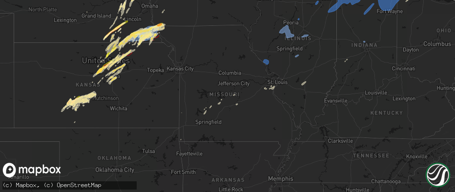
Hail Map in Missouri on May 18, 2026
The weather event in Missouri on May 18, 2026 includes Wind, Hail, and Tornado maps. 19 states and 1,691 cities were impacted and suffered possible damage. The total estimated number of properties impacted is 8,484.
Wind
Hail
Tornado
8,484
Estimated number of impacted properties by a 1.00" hail or larger2,557
Estimated number of impacted properties by a 1.75" hail or larger447
Estimated number of impacted properties by a 2.50" hail or largerStorm reports in Missouri
Missouri
| Date | Description |
|---|---|
| 05/18/20266:48 PM CDT | Downed wires near route u. Time confirmed from radar. |
| 05/18/20266:21 PM CDT | Downed wires near cooper street. Time estimated from radar. |
| 05/18/20266:18 PM CDT | Mo sema employee reported ping pong ball size hail. |
| 05/18/20266:17 PM CDT | Social media report. Time estimated from radar. |
| 05/18/20265:58 PM CDT | Em relayed spotter reported golf ball sized hail. |
| 05/18/20265:05 PM CDT | Pws measured multiple wind gusts over 60 mph... Including peak 75 mph. |
| 05/18/20265:05 PM CDT | Public relayed 60 mph winds with initial storms moving through. Time estimated from radar. |
| 05/18/20263:47 PM CDT | A large section of a home was blown in. Multiple trees were uprooted. |
| 05/18/20267:38 AM CDT | Relayed from social media: tree blocking highway 47 at big creek north of warrenton. Time estimated from radar. |
| 05/17/202611:21 PM CDT | Report relayed from social media... Destroyed outbuilding in windsor. Time estimated from radar. |
| 05/17/202610:36 PM CDT | Social media video of power flashes and downed power lines in carrollton. Time estimated from radar. |
| 05/17/202610:30 PM CDT | Downed wires near county road 623. Time estimated from radar. |
| 05/17/202610:28 PM CDT | Downed wires and power outages near county road 201. Time estimated from radar. |
| 05/17/202610:19 PM CDT | Wires down near route t. Time estimated from radar. |
| 05/17/202610:16 PM CDT | Several reports of downed wires and widespread power outages between hamilton and breckenridge. Time estimated from radar. |
| 05/17/202610:10 PM CDT | Social media report relayed of trees down... Time estimated from radar. |
| 05/17/202610:07 PM CDT | Reports of downed wires east of pleasant hill. Time estimated from radar. |
| 05/17/202610:04 PM CDT | Several large trees or limbs downed north of oak grove. Time estimated from radar. |
| 05/17/202610:04 PM CDT | Downed trees and power poles near and north of richmond. Time estimated from radar. |
| 05/17/202610:01 PM CDT | Downed tree at a residence southwest of richmond. Time estimated from radar. |
| 05/17/202610:00 PM CDT | Carport blown into a tree and downed limbs at a residence in odessa. Time estimated from radar. |
| 05/17/20269:53 PM CDT | Nws employee reported tree snapped and fallen. Time estimated from radar. |
| 05/17/20269:52 PM CDT | Nws employee reported multiple 4-6 inch diameter limbs down across the local area. Time estimated from radar. |
| 05/17/20269:52 PM CDT | Tds observed on radar at 9:52 pm cdt. |
| 05/17/20269:51 PM CDT | Two large tree limbs downed at a residence. Time estimated from radar. |
| 05/17/20269:51 PM CDT | Large tree down at a residence west of buckner. Time estimated from radar. |
| 05/17/20269:49 PM CDT | Photo relayed via social media of large tree branches broken off... Time estimated from radar. |
| 05/17/20269:49 PM CDT | Photo shared via social media of a tree blown over... Time estimated from radar. |
| 05/17/20269:49 PM CDT | Report of tree branches snapped... Time estimated from radar. |
| 05/17/20269:49 PM CDT | Lees summit municipal airport measured a 58 mph wind gust. |
| 05/17/20269:48 PM CDT | Photo relayed via social media of large tree branches down. Time estimated from radar/cross referenced with post. |
| 05/17/20269:47 PM CDT | Nws damage survey team confirmed an ef1 tornado occured monday evening... 5/18/2026... Beginning at 9:47 pm cdt in southwestern ray county missouri. This tornado caused |
| 05/17/20269:46 PM CDT | Large tree limbs down and a fence blown over. Winds estimated at 80 mph. Time estimated from radar. |
| 05/17/20269:46 PM CDT | Photo relayed via social media of tree tops broken off trees. Time estimated from radar. |
| 05/17/20269:46 PM CDT | Shared photos of damage to trees and fences... Time estimated from radar. |
| 05/17/20269:46 PM CDT | Downed trees near garnes and white oak. Time estimated from radar. |
| 05/17/20269:45 PM CDT | Pws measured 66 mph wind gust. |
| 05/17/20269:43 PM CDT | Photos relayed via social media of large tree branches down... Time estimated from radar. |
| 05/17/20269:43 PM CDT | Multiple social media reports of trees down in independence. Time estimated from radar. |
| 05/17/20269:40 PM CDT | Downed tree and wires near old state highway 210. Time estimated from radar. |
| 05/17/20269:40 PM CDT | Large tree downed near 84th and laurel. Time estimated from radar. |
| 05/17/20269:38 PM CDT | Report relayed via social media of power line down due to large tree branch snapping... Time estimated from radar. |
| 05/17/20269:37 PM CDT | Photo relayed via social media of a large tree branch down. Time estimated from radar. |
| 05/17/20269:37 PM CDT | Report relayed via social media of multiple downed trees/tree limbs. Time estimated from radar. |
| 05/17/20269:37 PM CDT | Large tree down on truman road east of i-435. Time estimated from radar. |
| 05/17/20269:36 PM CDT | Photo relayed via social media of a large tree branch down. Time estimated from radar. |
| 05/17/20269:36 PM CDT | Law enforcement measured a 63 mph wind gust. |
| 05/17/20269:35 PM CDT | Several trees down near 44th street. Time estimated from radar. |
| 05/17/20269:35 PM CDT | Tree partially over stadium drive. |
| 05/17/20269:35 PM CDT | Downed wires near cambridge avenue. Time estimated from radar. |
| 05/17/20269:35 PM CDT | Social media report. Snapped tree on 39th street. Time estimated from radar. |
| 05/17/20269:35 PM CDT | Downed trees and limbs west of i-35 and route 291. Time estimated from radar. |
| 05/17/20269:34 PM CDT | Social media relayed report of downed trees. Time estimated from radar. |
| 05/17/20269:32 PM CDT | Several reports of downed tree limbs and wires near hardesty avenue. Time estimated from radar. |
| 05/17/20269:32 PM CDT | Blown transformer and power lines down in gladstone. Time estimated from radar. |
| 05/17/20269:30 PM CDT | Pws measured 59 mph wind gust. |
| 05/17/20269:30 PM CDT | Downed tree branch on overheard wires of streetcar... Suspending service. Time estimated from radar. |
| 05/17/20269:30 PM CDT | Downed tree and wires near bienheim park. Time estimated from radar. |
| 05/17/20269:29 PM CDT | Downtown kansas city ap measured 64 mph wind gusts. |
| 05/17/20269:29 PM CDT | Pws measured 65 mph wind gust. |
| 05/17/20269:29 PM CDT | Several trees down... Including one through a house. Time estimated from radar. |
| 05/17/20269:29 PM CDT | Downed wires near sunnybrook lane. Time estimated from radar. |
| 05/17/20269:27 PM CDT | Report of 65 mph wind gust. |
| 05/17/20269:27 PM CDT | Downed tree relayed from social media. Time estimated from radar. |
| 05/17/20269:27 PM CDT | Photo relayed via social media of large tree uprooted with branches broken off... Time estimated from radar. |
| 05/17/20269:27 PM CDT | Downed tree and limbs cherry street. Time confirmed from radar. |
| 05/17/20269:26 PM CDT | Downed tree and wires near 65th terrace. Time confirmed from radar. |
| 05/17/20269:26 PM CDT | Large tree uprooted near 72nd terrace. Time estimated from radar. |
| 05/17/20269:24 PM CDT | Photo relayed via social media of tree branches snapped/trees down. Time estimated from radar. |
| 05/17/20269:24 PM CDT | Downed tree and wires near 86th street. Time confirmed from radar. |
| 05/17/20269:24 PM CDT | Em relayed public report of 70 mph wind gust. |
| 05/17/20269:23 PM CDT | Downed wires near cerrito lane. Time estimated from radar. |
| 05/17/20269:18 PM CDT | Report of 60 mph gust relayed from em. |
| 05/17/20269:17 PM CDT | Multiple downed trees/limbs reported via social media. Time estimated from radar. |
| 05/17/20269:16 PM CDT | Photo shared via social media of large tree snapped at trunk... Time estimated from radar. |
| 05/17/20269:15 PM CDT | Downed tree limbs reported via social media. Time estimated from radar. |
| 05/17/20269:07 PM CDT | Measured from handheld anemometer. |
| 05/17/20269:01 PM CDT | Social media reports of downed tree limbs and wires near pattonsburg. Time estimated from radar. |
| 05/17/20268:55 PM CDT | Downed wires near elm road. Time estimated from radar. |
| 05/17/20268:48 PM CDT | Downed wires near lakesite road. Time estimated from radar. |
| 05/17/20268:46 PM CDT | Report of trees down and road closure. Photos shared show trees split down to trunks with large branches down... Minor structures blown over. Time estimated from radar. |
| 05/17/20268:43 PM CDT | Report relayed via social media of downed trees and power lines. Time estimated from radar. |
| 05/17/20268:43 PM CDT | Pws measured gust. |
| 05/17/20268:37 PM CDT | Several reports of downed wires northwest of king city. Time estimated from radar. |
| 05/17/20268:37 PM CDT | Several reports of downed tree limbs and wires in st. Joseph. Time estimated from radar. |
| 05/17/20268:37 PM CDT | Social media report of a barn roof blown off. Time estimated from radar. |
| 05/17/20268:33 PM CDT | Pws measured 65 mph gust. |
| 05/17/20268:31 PM CDT | Pws measured 58 mph gust. |
| 05/17/20268:22 PM CDT | Downed trees and wires in bolckow. Time estimated from radar. |
| 05/17/20268:22 PM CDT | Several reports of downed trees and wires and property damage on county road 191. Time estimated from radar. |
| 05/17/20268:20 PM CDT | Photos relayed of trees limbs down/uprooted trees. Time estimated from radar. |
| 05/17/20268:19 PM CDT | Relayed social media report of multiple trees down. Time estimated from radar. |
| 05/17/20268:16 PM CDT | Social media relayed a report of a downed tree damaging a vehicle. Time estimated from radar. |
| 05/17/20268:14 PM CDT | Photos relayed of large tree branches down/snapped at trunks. Time estimated from radar. |
| 05/17/20268:14 PM CDT | Several trees blown down in fillmore. Time estimated from radar. |
| 05/17/20268:14 PM CDT | Social media relayed photos of large tree branches down... Time estimated from radar. |
| 05/17/20268:13 PM CDT | Kstj asos recorded 61 mph wind gust. |
| 05/17/20268:12 PM CDT | Photos relayed of large tree branches down/trees snapped at trunks. Time estimated from radar. |
| 05/17/20268:05 PM CDT | Downed wires and power outages near riverbreaks conservation area. Time estimated from radar. |
| 05/17/20267:29 PM CDT | Report from mping: quarter |
| 05/17/20267:13 PM CDT | Multiple reports of a tornado southwest of grant city from the public and from an emergency manager. No known reports of damage at this time. Time and location approxim |
| 05/17/20267:08 PM CDT | Multiple reports of downed wires west of fairfax. Time estimated from radar. |
| 05/17/20267:01 PM CDT | Hail up to ping pong in size. |
| 05/17/20267:00 PM CDT | Em relayed pictures of hail next to ruler. Largest greater than 2.5 inches in diameter. |
All States Impacted by Hail Map on May 18, 2026
Cities Impacted by Hail Map on May 18, 2026
- Nebo, IL
- Kampsville, IL
- Hamburg, IL
- Eldred, IL
- Pearl, IL
- White Hall, IL
- Boelus, NE
- Canton, IL
- Lewistown, IL
- Liverpool, IL
- Topeka, IL
- Havana, IL
- Manito, IL
- Glasford, IL
- Forest City, IL
- Pekin, IL
- Green Valley, IL
- Kingston Mines, IL
- Mapleton, IL
- Peoria, IL
- San Jose, IL
- Mason City, IL
- Easton, IL
- Hartsburg, IL
- New Holland, IL
- South Pekin, IL
- Emden, IL
- Delavan, IL
- Roanoke, IL
- Clinton, IL
- Waynesville, IL
- Wapella, IL
- Dewitt, IL
- Farmer City, IL
- Le Roy, IL
- Taylorville, IL
- Palmer, IL
- Centralia, IL
- Odin, IL
- Salem, IL
- Morris, IL
- Minooka, IL
- Catawissa, MO
- Robertsville, MO
- Pacific, MO
- Cedar Hill, MO
- House Springs, MO
- Collinsville, IL
- Imperial, MO
- Fenton, MO
- New Lenox, IL
- Mokena, IL
- Oak Lawn, IL
- Chicago Ridge, IL
- Tinley Park, IL
- Hometown, IL
- Orland Park, IL
- Alsip, IL
- Evergreen Park, IL
- Chicago, IL
- Palos Heights, IL
- Palos Park, IL
- Bridgeview, IL
- Palos Hills, IL
- Worth, IL
- Burbank, IL
- Cicero, IL
- Riverside, IL
- Hickory Hills, IL
- La Grange, IL
- Justice, IL
- Berwyn, IL
- Summit Argo, IL
- Lyons, IL
- Willow Springs, IL
- Oak Park, IL
- Highland, IN
- Calumet City, IL
- Markham, IL
- Midlothian, IL
- Dolton, IL
- Country Club Hills, IL
- Gary, IN
- Homewood, IL
- Whiting, IN
- Thornton, IL
- Frankfort, IL
- Munster, IN
- Olympia Fields, IL
- Flossmoor, IL
- Hazel Crest, IL
- Chicago Heights, IL
- South Holland, IL
- East Chicago, IN
- Oak Forest, IL
- Harvey, IL
- Hammond, IN
- Crestwood, IL
- Robbins, IL
- Matteson, IL
- Glenwood, IL
- Lansing, IL
- Blue Island, IL
- Posen, IL
- Riverdale, IL
- Homer Glen, IL
- Griffith, IN
- Park Forest, IL
- Steger, IL
- Richton Park, IL
- University Park, IL
- Monee, IL
- Arnold, MO
- Saint Louis, MO
- Schererville, IN
- Dyer, IN
- Saint John, IN
- Crete, IL
- Merrillville, IN
- Cedar Lake, IN
- Lowell, IN
- Crown Point, IN
- Momence, IL
- Grant Park, IL
- Bradley, IL
- Bourbonnais, IL
- Pembroke Township, IL
- Manteno, IL
- Saint Anne, IL
- Kankakee, IL
- Beecher, IL
- Aroma Park, IL
- Chebanse, IL
- Lake Village, IN
- Schneider, IN
- Hebron, IN
- Hobart, IN
- Lake Station, IN
- Portage, IN
- Valparaiso, IN
- Westville, IN
- Chesterton, IN
- Union Mills, IN
- Wanatah, IN
- Kouts, IN
- Boone Grove, IN
- Kingsford Heights, IN
- La Porte, IN
- Hamlet, IN
- Michigan City, IN
- La Crosse, IN
- Hanna, IN
- Knox, IN
- Beverly Shores, IN
- Noel, MO
- New Buffalo, MI
- Lakeside, MI
- Rolling Prairie, IN
- Union Pier, MI
- Three Oaks, MI
- Bridgman, MI
- Sawyer, MI
- Walkerton, IN
- Mill Creek, IN
- Harbert, MI
- New Carlisle, IN
- Galien, MI
- New Troy, MI
- Baroda, MI
- Stevensville, MI
- Buchanan, MI
- North Liberty, IN
- Grovertown, IN
- South Bend, IN
- Saint Joseph, MI
- Berrien Springs, MI
- Niles, MI
- Clay City, IN
- Centerpoint, IN
- Benton Harbor, MI
- Sodus, MI
- Coloma, MI
- Eau Claire, MI
- Berrien Center, MI
- Notre Dame, IN
- Liberal, MO
- Granger, IN
- Mishawaka, IN
- Louisburg, MO
- Urbana, MO
- Half Way, MO
- Dowagiac, MI
- Watervliet, MI
- Bangor, MI
- Decatur, MI
- Covert, MI
- Hartford, MI
- South Haven, MI
- Edwardsburg, MI
- Cassopolis, MI
- Bourbon, IN
- Mentone, IN
- Tippecanoe, IN
- Rochester, IN
- Akron, IN
- Claypool, IN
- Etna Green, IN
- Warsaw, IN
- Lawton, MI
- Lawrence, MI
- Marcellus, MI
- Paw Paw, MI
- Vandalia, MI
- Kingsley, MI
- Traverse City, MI
- Williamsburg, MI
- South Boardman, MI
- Kalkaska, MI
- Grand Junction, MI
- Allegan, MI
- Bloomingdale, MI
- Pullman, MI
- Fennville, MI
- Leesburg, IN
- Atwood, IN
- Gobles, MI
- Jones, MI
- Schoolcraft, MI
- Mattawan, MI
- Kalamazoo, MI
- Simpson, KS
- Vanderbilt, MI
- Elmira, MI
- Hamilton, MI
- Otsego, MI
- Hopkins, MI
- Marco Island, FL
- Jamestown, KS
- Gaylord, MI
- Dorr, MI
- Martin, MI
- Shelbyville, MI
- Wayland, MI
- Wilson, KS
- Sylvan Grove, KS
- Ashmore, IL
- Concordia, KS
- Scandia, KS
- Norway, KS
- Bolivar, MO
- Aldrich, MO
- Walnut Grove, MO
- Morrisville, MO
- Plainwell, MI
- Portage, MI
- Vicksburg, MI
- Lincoln, KS
- Hastings, MI
- Claflin, KS
- Mendon, MI
- Leonidas, MI
- Milan, MI
- Colon, MI
- Sherwood, MI
- Richland, MI
- Grandville, MI
- Rockford, MI
- Grand Rapids, MI
- Caledonia, MI
- Belmont, MI
- Wyoming, MI
- Byron Center, MI
- Cedar Springs, MI
- Middleville, MI
- Ada, MI
- Comstock Park, MI
- Hudsonville, MI
- Allendale, MI
- Zeeland, MI
- Marne, MI
- Jenison, MI
- Lake Odessa, MI
- Dowling, MI
- Climax, MI
- Ceresco, MI
- Galesburg, MI
- Bellevue, MI
- Scotts, MI
- Lowell, MI
- Augusta, MI
- Freeport, MI
- Nashville, MI
- Delton, MI
- Alto, MI
- Battle Creek, MI
- Hickory Corners, MI
- East Leroy, MI
- Clarksville, MI
- Marshall, MI
- Holyrood, KS
- Hebron, NE
- Deshler, NE
- Washington, KS
- Fenwick, MI
- Saranac, MI
- Olivet, MI
- Sheridan, MI
- Sidney, MI
- Gowen, MI
- Woodland, MI
- Vermontville, MI
- Stanton, MI
- Greenville, MI
- Orleans, MI
- Ionia, MI
- Belding, MI
- Sand Lake, MI
- Trufant, MI
- Homer, MI
- Albion, MI
- Charlotte, MI
- Sunfield, MI
- Tekonsha, MI
- Burlington, MI
- Coldwater, MI
- Kendallville, IN
- Howe, IN
- Athens, MI
- Auburn, IN
- Pleasant Lake, IN
- Lagrange, IN
- Huntertown, IN
- Angola, IN
- Hudson, IN
- Bronson, MI
- Avilla, IN
- Garrett, IN
- Fremont, IN
- Fort Wayne, IN
- Corunna, IN
- Quincy, MI
- Laotto, IN
- Ashley, IN
- Wolcottville, IN
- Union City, MI
- Orland, IN
- Waterloo, IN
- Montgomery, MI
- New Haven, IN
- Antwerp, OH
- Harlan, IN
- Convoy, OH
- Saint Joe, IN
- Leo, IN
- Reading, MI
- Hamilton, IN
- Spencerville, IN
- Hoagland, IN
- Woodburn, IN
- Hicksville, OH
- Grabill, IN
- Monroeville, IN
- Butler, IN
- Payne, OH
- Edon, OH
- Paulding, OH
- Scott, OH
- Cecil, OH
- Montpelier, OH
- Haviland, OH
- Defiance, OH
- Grover Hill, OH
- Bryan, OH
- Litchfield, MI
- Mark Center, OH
- Fort Jennings, OH
- Camden, MI
- Van Wert, OH
- Ney, OH
- Ottoville, OH
- Hillsdale, MI
- Oakwood, OH
- Melrose, OH
- Pioneer, OH
- Sherwood, OH
- Latty, OH
- Cloverdale, OH
- Edgerton, OH
- Allen, MI
- Middle Point, OH
- Willis, MI
- Rome City, IN
- Burr Oak, MI
- Albion, IN
- Arcola, IN
- South Milford, IN
- Churubusco, IN
- Fulton, MI
- Sturgis, MI
- Three Rivers, MI
- Centreville, MI
- Wawaka, IN
- Columbia City, IN
- Kimmell, IN
- Topeka, IN
- Shipshewana, IN
- Goshen, IN
- Millersburg, IN
- Constantine, MI
- Middlebury, IN
- Ligonier, IN
- White Pigeon, MI
- Belvidere, NE
- Hollenberg, KS
- Morrowville, KS
- Belleville, KS
- Barnard, KS
- Haddam, KS
- Cromwell, IN
- Mahaska, KS
- Pierceton, IN
- Larwill, IN
- Zionsville, IN
- Sheridan, IN
- Westfield, IN
- Carleton, NE
- Beloit, KS
- Stryker, OH
- Archbold, OH
- Evansport, OH
- Endicott, NE
- Steele City, NE
- Diller, NE
- Lyons, OH
- Hillman, MI
- Lyons, MI
- Portland, MI
- Agenda, KS
- Mulliken, MI
- Atlanta, MI
- Clifton, KS
- Napoleon, OH
- Minneapolis, KS
- Eaton Rapids, MI
- West Unity, OH
- Concord, MI
- Muir, MI
- Springport, MI
- Hanover, MI
- Grand Ledge, MI
- Osseo, MI
- Jonesville, MI
- Carson City, MI
- Onondaga, MI
- Dimondale, MI
- Okemos, MI
- Spring Arbor, MI
- Eagle, MI
- Clarklake, MI
- Fowler, MI
- Rives Junction, MI
- Parma, MI
- Jerome, MI
- Haslett, MI
- Potterville, MI
- North Adams, MI
- Horton, MI
- East Lansing, MI
- Hubbardston, MI
- Jackson, MI
- Westphalia, MI
- Saint Johns, MI
- Bath, MI
- Dewitt, MI
- Laingsburg, MI
- Lansing, MI
- Pewamo, MI
- Alvordton, OH
- Pittsford, MI
- Waldron, MI
- Mason, MI
- Holt, MI
- Leslie, MI
- Jasper, MI
- Fairbury, NE
- Cuba, KS
- Lachine, MI
- Fort Stockton, TX
- Delphos, KS
- Beverly, KS
- Iraan, TX
- Glasco, KS
- Jansen, NE
- Beatrice, NE
- Odell, NE
- Delta, OH
- Alpena, MI
- Narka, KS
- Blue Springs, NE
- Aurora, KS
- Miltonvale, KS
- Eldridge, MO
- Dixon, MO
- Meta, MO
- Brinktown, MO
- Camdenton, MO
- Linn Creek, MO
- Clyde, KS
- Filley, NE
- Burton, MI
- Flint, MI
- Lorraine, KS
- Wymore, NE
- Mathias, WV
- Baker, WV
- Tescott, KS
- Pickrell, NE
- Adams, NE
- Crab Orchard, NE
- Tecumseh, NE
- Offerle, KS
- Davison, MI
- Spearville, KS
- Kinsley, KS
- Mount Vernon, IN
- Virginia, NE
- Kanopolis, KS
- Ellsworth, KS
- Morganville, KS
- Bucklin, KS
- Schuyler, NE
- Bee, NE
- Valparaiso, NE
- Howells, NE
- Clarkson, NE
- Lewis, KS
- Sterling, NE
- Steinauer, NE
- Leigh, NE
- Lewiston, NE
- Garfield, KS
- Larned, KS
- Fairmont, NE
- Ford, KS
- De Witt, NE
- Brookville, KS
- Clay Center, KS
- Hanover, KS
- Wisner, NE
- Pilger, NE
- Stanton, NE
- Liberty, NE
- Burchard, NE
- Pawnee City, NE
- Wright, KS
- Dodge City, KS
- Beemer, NE
- Dodge, NE
- West Point, NE
- Ortonville, MI
- Hamburg, MI
- White Lake, MI
- Grand Blanc, MI
- Hadley, MI
- Bancroft, MI
- Linden, MI
- Brighton, MI
- Swartz Creek, MI
- Perry, MI
- Davisburg, MI
- Stockbridge, MI
- Clarkston, MI
- Highland, MI
- Norvell, MI
- Lapeer, MI
- Pleasant Lake, MI
- Gaines, MI
- Whitmore Lake, MI
- Grass Lake, MI
- Hudson, MI
- Webberville, MI
- Hartland, MI
- Napoleon, MI
- Clayton, MI
- Byron, MI
- Gregory, MI
- Munith, MI
- Goodrich, MI
- Dexter, MI
- Cement City, MI
- Michigan Center, MI
- Somerset Center, MI
- Manitou Beach, MI
- Dansville, MI
- Williamston, MI
- Pinckney, MI
- Howell, MI
- Milford, MI
- Attica, MI
- Adrian, MI
- Addison, MI
- Atlas, MI
- Fenton, MI
- Morrice, MI
- Owosso, MI
- Manchester, MI
- Ann Arbor, MI
- Durand, MI
- Fowlerville, MI
- Tipton, MI
- Onsted, MI
- Chelsea, MI
- Lennon, MI
- Metamora, MI
- Holly, MI
- Brooklyn, MI
- Beattie, KS
- Cook, NE
- Elk Creek, NE
- Burr, NE
- Table Rock, NE
- Auburn, NE
- Humboldt, NE
- Brock, NE
- Johnson, NE
- Vernon, MI
- Ovid, MI
- Corunna, MI
- Elsie, MI
- Columbiaville, MI
- Flushing, MI
- Du Bois, NE
- Talmage, NE
- Dawson, NE
- Stella, NE
- Staplehurst, NE
- Seward, NE
- Superior, NE
- Summerfield, KS
- Home, KS
- Weston, NE
- Dwight, NE
- Salina, KS
- McCool Junction, NE
- Waco, NE
- York, NE
- Oketo, KS
- Star Tannery, VA
- Clinton, MI
- Northville, MI
- Sand Creek, MI
- Wixom, MI
- New Hudson, MI
- Morenci, MI
- Tecumseh, MI
- Commerce Township, MI
- Fayette, OH
- Saline, MI
- Waterford, MI
- Britton, MI
- Palmyra, MI
- South Lyon, MI
- Oxford, MI
- Oak, NE
- Davenport, NE
- Livonia, MI
- Plymouth, MI
- Oakland, MI
- Dearborn Heights, MI
- Canton, MI
- Farmington, MI
- Blissfield, MI
- Newport, MI
- Detroit, MI
- Southfield, MI
- Westland, MI
- Pontiac, MI
- Redford, MI
- Taylor, MI
- Rockwood, MI
- Lake Orion, MI
- Dryden, MI
- Maybee, MI
- Petersburg, MI
- Keego Harbor, MI
- Auburn Hills, MI
- Birmingham, MI
- Carleton, MI
- Dearborn, MI
- Monroe, MI
- Rochester, MI
- Inkster, MI
- Ida, MI
- Garden City, MI
- Flat Rock, MI
- Romulus, MI
- West Bloomfield, MI
- Ypsilanti, MI
- Franklin, MI
- Novi, MI
- Wayne, MI
- Dundee, MI
- Belleville, MI
- Bloomfield Hills, MI
- Deerfield, MI
- Walled Lake, MI
- South Rockwood, MI
- New Boston, MI
- Nelson, NE
- Greenleaf, KS
- Palmer, KS
- Winchester, VA
- Strasburg, VA
- Courtland, KS
- Hubbell, NE
- Munden, KS
- Morse Bluff, NE
- Cedar Bluffs, NE
- Almont, MI
- Lindsborg, KS
- Brainard, NE
- David City, NE
- North Bend, NE
- Prague, NE
- Malmo, NE
- Bennington, KS
- Metamora, OH
- Riga, MI
- Ames, NE
- Ruskin, NE
- Ottawa Lake, MI
- Berkey, OH
- Surprise, NE
- Quanah, TX
- Swanton, OH
- Ulysses, NE
- Chester, NE
- Bancroft, NE
- Pender, NE
- Gresham, NE
- Falun, KS
- Bruno, NE
- Shickley, NE
- Eldorado, OK
- Gould, OK
- Duke, OK
- Bern, KS
- Sabetha, KS
- Brownville, NE
- Peru, NE
- Julian, NE
- Walthill, NE
- Solomon, KS
- Rising City, NE
- Strang, NE
- Bruning, NE
- Green, KS
- Hooper, NE
- Winslow, NE
- Fremont, NE
- Stephens City, VA
- Middletown, VA
- Geneva, NE
- Reynolds, NE
- Nebraska City, NE
- Rock Port, MO
- Linwood, NE
- La Salle, MI
- Shubert, NE
- Watson, MO
- Nemaha, NE
- Temperance, MI
- Ohiowa, NE
- Tobias, NE
- Milligan, NE
- River Rouge, MI
- Imlay City, MI
- Sterling Heights, MI
- Ferndale, MI
- Washington, MI
- Ecorse, MI
- Trenton, MI
- Romeo, MI
- Madison Heights, MI
- Pleasant Ridge, MI
- Royal Oak, MI
- Highland Park, MI
- Wyandotte, MI
- Grosse Ile, MI
- Lincoln Park, MI
- Warren, MI
- Hazel Park, MI
- Southgate, MI
- Utica, MI
- Center Line, MI
- Melvindale, MI
- Huntington Woods, MI
- Leonard, MI
- Riverview, MI
- Oak Park, MI
- Clawson, MI
- Hamtramck, MI
- Allen Park, MI
- Berkley, MI
- Troy, MI
- Coldwater, KS
- Belpre, KS
- St John, KS
- Hamburg, IA
- Alexandria, NE
- Herman, NE
- Craig, NE
- Tekamah, NE
- Oakland, NE
- Bellwood, NE
- Macksville, KS
- Columbus, NE
- Abilene, KS
- New Cambria, KS
- Longford, KS
- Hudson, KS
- Gerrardstown, WV
- Rogers, NE
- Verdon, NE
- Farragut, IA
- Riverton, IA
- Northboro, IA
- Shenandoah, IA
- Creston, NE
- Newburg, MO
- Duke, MO
- Hawarden, IA
- Hornick, IA
- Salix, IA
- Bronson, IA
- Sloan, IA
- Winnebago, NE
- Assaria, KS
- Onawa, IA
- Whiting, IA
- Decatur, NE
- Friend, NE
- Westboro, MO
- Barnes, KS
- Gypsum, KS
- Linn, KS
- Waterville, KS
- Western, NE
- Daykin, NE
- Tarkio, MO
- Marysville, KS
- Wakefield, KS
- Capac, MI
- Emmett, MI
- Allenton, MI
- Yale, MI
- Scribner, NE
- Dorchester, NE
- Greensburg, KS
- Akron, IA
- Westfield, IA
- Hastings, IA
- Emerson, IA
- Brown City, MI
- Melvin, MI
- Avoca, MI
- Coin, IA
- Randolph, KS
- Falls City, NE
- Crete, NE
- Pleasant Dale, NE
- Milford, NE
- Denton, NE
- Mangum, OK
- Haviland, KS
- Raymond, KS
- Alden, KS
- Sylvia, KS
- Rock Valley, IA
- Exeter, NE
- Climbing Hill, IA
- Smithland, IA
- Correctionville, IA
- Anthon, IA
- Moville, IA
- Oto, IA
- Lyons, NE
- Blanchard, IA
- Snyder, NE
- Stafford, KS
- Talmage, KS
- Red Oak, IA
- Armada, MI
- Sterling, KS
- Ellinwood, KS
- Byers, KS
- Blue Rapids, KS
- Rodney, IA
- Fairfax, MO
- Beaver Crossing, NE
- Carter, OK
- Dill City, OK
- Elk City, OK
- Quimby, IA
- Washta, IA
- Pierson, IA
- Holstein, IA
- Cushing, IA
- Macy, NE
- Uehling, NE
- Cherokee, IA
- Aurelia, IA
- Wayne, NE
- Clarinda, IA
- Elmo, MO
- Wakefield, NE
- College Springs, IA
- Utica, NE
- Goehner, NE
- Lyons, KS
- Chase, KS
- Plevna, KS
- Junction City, KS
- Milford, KS
- Chapman, KS
- Elliott, IA
- Griswold, IA
- Rosalie, NE
- Syracuse, NE
- Alton, IA
- Hospers, IA
- Gilead, NE
- Garland, NE
- Braddyville, IA
- Kingsley, IA
- Shambaugh, IA
- Clearmont, MO
- Burlington Junction, MO
- New Market, IA
- Abbyville, KS
- Bedford, IA
- Partridge, KS
- Hutchinson, KS
- Nickerson, KS
- Inman, KS
- South Hutchinson, KS
- Allen, NE
- Concord, NE
- Ceresco, NE
- Unadilla, NE
- Douglas, NE
- Riley, KS
- Iuka, KS
- Canute, OK
- Pratt, KS
- Frankfort, KS
- Leonardville, KS
- Junction, IL
- Turon, KS
- Sullivan, MO
- Craig, MO
- Dixon, NE
- Little River, KS
- Shawneetown, IL
- Enterprise, KS
- Arlington, KS
- Buhler, KS
- Haven, KS
- Sanborn, IA
- Ponca, NE
- Waterbury, NE
- Corning, IA
- Cumberland, IA
- Sheldon, IA
- Hope, KS
- Fort Riley, KS
- Skidmore, MO
- Wiota, IA
- Sidney, IA
- Archer, IA
- Wahoo, NE
- Windom, KS
- Ocheyedan, IA
- Harris, IA
- Union, NE
- Mcpherson, KS
- Massena, IA
- Sturgis, KY
- Vermillion, KS
- Dunbar, NE
- Morganfield, KY
- Hartley, IA
- Matthews, MO
- Weeping Water, NE
- Avoca, NE
- Butler, OK
- Hopkins, MO
- Axtell, KS
- Lonedell, MO
- Richwoods, MO
- Otoe, NE
- Burrton, KS
- Raymond, NE
- Plymouth, NE
- Elk Point, SD
- Redding, IA
- Sheridan, MO
- Clearfield, IA
- Pickering, MO
- Gravity, IA
- Blockton, IA
- Bridgewater, IA
- Randolph, IA
- Lake Park, IA
- Wilber, NE
- Swanton, NE
- Bertrand, MO
- Lincoln, NE
- Ogden, KS
- Maryville, MO
- Nehawka, NE
- Manhattan, KS
- Woodbine, KS
- Baileyville, KS
- Jefferson, SD
- Marianna, AR
- Seneca, KS
- Uniontown, KY
- Colon, NE
- Fort Calhoun, NE
- Omaha, NE
- Parnell, MO
- Moundridge, KS
- Prescott, IA
- Fontanelle, IA
- Canton, KS
- Galva, KS
- Westmoreland, KS
- Saint George, KS
- Oneida, KS
- Olsburg, KS
- Ong, NE
- Miller City, IL
- Plattsmouth, NE
- Greenfield, IA
- Spirit Lake, IA
- Milford, IA
- Murray, NE
- Malvern, IA
- Tabor, IA
- Glenwood, IA
- Benton, IA
- Grant City, MO
- Ithaca, NE
- Armstrong, IA
- Swea City, IA
- Wamego, KS
- Alma, KS
- Cairo, IL
- Mounds, IL
- Davey, NE
- Onaga, KS
- Herington, KS
- Pretty Prairie, KS
- Waverly, NE
- Centralia, KS
- Durham, KS
- Clatonia, NE
- Earlham, IA
- Bennington, NE
- Dwight, KS
- Alta Vista, KS
- Halstead, KS
- White City, KS
- Hillsboro, KS
- Hesston, KS
- Ledyard, IA
- Havensville, KS
- Corning, KS
- Goff, KS
- Soldier, KS
- Edgar, NE
- Cunningham, KS
- Diagonal, IA
- Blue Earth, MN
- Ashland, NE
- Greenwood, NE
- Salem, NE
- Newton, KS
- Goessel, KS
- Marion, KS
- Afton, IA
- Thayer, IA
- Shannon City, IA
- Ellston, IA
- Tingley, IA
- Mount Ayr, IA
- Persia, IA
- Neola, IA
- Logan, IA
- Ramona, KS
- Lincolnville, KS
- Tampa, KS
- Lost Springs, KS
- Elkhorn, NE
- Missouri Valley, IA
- Honey Creek, IA
- Van Meter, IA
- Winterset, IA
- De Soto, IA
- Belvue, KS
- Mount Hope, KS
- Bremen, KS
- Circleville, KS
- Holton, KS
- Portsmouth, IA
- Emmett, KS
- Saint Marys, KS
- Paxico, KS
- Delia, KS
- Fairview, KS
- Hiawatha, KS
- Blanchard, PA
- Beech Creek, PA
- Howard, PA
- Sedgwick, KS
- Burdick, KS
- Wilsey, KS
- Council Grove, KS
- Walton, KS
- Peabody, KS
- Isabel, KS
- Sun City, KS
- Coats, KS
- Percival, IA
- Prole, IA
- Ida Grove, IA
- Battle Creek, IA
- Mayetta, KS
- Cumming, IA
- West Des Moines, IA
- Norwalk, IA
- Netawaka, KS
- Sawyer, KS
- Wetmore, KS
- Strong City, KS
- Whiting, KS
- Rossville, KS
- Eskridge, KS
- Maple Hill, KS
- Topeka, KS
- McFarland, KS
- Harveyville, KS
- Allen, KS
- Kellerton, IA
- Hatfield, MO
- Grand River, IA
- Americus, KS
- Silver Lake, KS
- White Cloud, KS
- Robinson, KS
- Rulo, NE
- Horton, KS
- Powhattan, KS
- Muscotah, KS
- Kingman, KS
- North Newton, KS
- Nashville, KS
- Cedar Point, KS
- Indianola, IA
- Colwich, KS
- Lancaster, KS
- Everest, KS
- Denison, KS
- Carbondale, KS
- Burlingame, KS
- Reading, KS
- Hoyt, KS
- Wakarusa, KS
- Auburn, KS
- Mound City, MO
- Maitland, MO
- Oregon, MO
- Valley Falls, KS
- Spivey, KS
- Florence, KS
- Elmdale, KS
- Denton, KS
- Effingham, KS
- Highland, KS
- Forest City, MO
- Bendena, KS
- Troy, KS
- Andale, KS
- Zenda, KS
- Bentley, KS
- Ravenwood, MO
- Valley Center, KS
- Meriden, KS
- Berryton, KS
- Atchison, KS
- Wathena, KS
- Saint Joseph, MO
- Elwood, KS
- Cottonwood Falls, KS
- Amazonia, MO
- Fillmore, MO
- Savannah, MO
- Admire, KS
- Emporia, KS
- Bolckow, MO
- Graham, MO
- Barnard, MO
- Scranton, KS
- Nortonville, KS
- Matfield Green, KS
- Burns, KS
- Union Star, MO
- Osage City, KS
- Cosby, MO
- Helena, MO
- Whitewater, KS
- Isanti, MN
- Saint Francis, MN
- Zimmerman, MN
- Rea, MO
- Rosendale, MO
- State Center, IA
- Worth, MO
- Potwin, KS
- Murdock, KS
- Cheney, KS
- Garden Plain, KS
- Tecumseh, KS
- Grantville, KS
- Quenemo, KS
- Overbrook, KS
- Cummings, KS
- King City, MO
- Winchester, KS
- Attica, KS
- McLouth, KS
- El Dorado, KS
- Cassoday, KS
- Oskaloosa, KS
- Ozawkie, KS
- Lawrence, KS
- Lecompton, KS
- Perry, KS
- Easton, KS
- Leavenworth, KS
- Tonganoxie, KS
- Eudora, KS
- Baldwin City, KS
- Lansing, KS
- Pomona, KS
- Bonner Springs, KS
- Ottawa, KS
- De Soto, KS
- Linwood, KS
- Basehor, KS
- Wellsville, KS
- Conception Junction, MO
- Stanberry, MO
- Albany, MO
- Martinsville, MO
- Eagleville, MO
- Ridgeway, MO
- Denver, MO
- New Hampton, MO
- Bethany, MO
- Gentry, MO
- Clyde, MO
- Conception, MO
- Darlington, MO
- Lamoni, IA
- Davis City, IA
- Cainsville, MO
- Blythedale, MO
- Decatur, IA
- Leon, IA
- Gilman City, MO
- Chatsworth, IA
- Princeton, MO
- Wichita, KS
- Maize, KS
- Goddard, KS
- Haysville, KS
- Clearwater, KS
- Jamesport, MO
- Shawnee, KS
- Gardner, KS
- Paola, KS
- Spring Hill, KS
- Edgerton, KS
- New Century, KS
- Olathe, KS
- Platte City, MO
- Rantoul, KS
- Lenexa, KS
- Kansas City, KS
- Harper, KS
- Olpe, KS
- Amity, MO
- Maysville, MO
- Clarksdale, MO
- Pattonsburg, MO
- McFall, MO
- Weatherby, MO
- Coffey, MO
- Jameson, MO
- Kechi, KS
- Mcconnell Afb, KS
- Derby, KS
- Mercer, MO
- Spickard, MO
- Lineville, IA
- Osceola, IA
- Garden Grove, IA
- Weldon, IA
- Van Wert, IA
- Murray, IA
- Humeston, IA
- Trenton, MO
- Madison, KS
- Chariton, IA
- Norwich, KS
- Eureka, KS
- Mondovi, WI
- Easton, MO
- Stewartsville, MO
- Altamont, MO
- Winston, MO
- Gallatin, MO
- Cameron, MO
- Osborn, MO
- Stilwell, KS
- Independence, MO
- Waldron, MO
- Farley, MO
- Liberty, MO
- Bucyrus, KS
- Overland Park, KS
- Prairie Village, KS
- Kansas City, MO
- Mission, KS
- Leawood, KS
- Riverside, MO
- Louisburg, KS
- Rose Hill, KS
- Greenwich, KS
- Towanda, KS
- Andover, KS
- Benton, KS
- Hartford, KS
- Gridley, KS
- Neosho Rapids, KS
- Burlington, KS
- Lebo, KS
- Waverly, KS
- Smithville, MO
- Kearney, MO
- Holt, MO
- Excelsior Springs, MO
- Corydon, IA
- Woodburn, IA
- Allerton, IA
- Clio, IA
- Derby, IA
- Lucas, IA
- Lucerne, MO
- Seymour, IA
- Powersville, MO
- Augusta, KS
- Douglass, KS
- Brooklyn, IA
- Eleva, WI
- Milton, KS
- Plattsburg, MO
- Orrick, MO
- Rayville, MO
- Conway Springs, KS
- Argonia, KS
- Anthony, KS
- Danville, KS
- Viola, KS
- Cleveland, MO
- Blue Springs, MO
- Freeman, MO
- Pleasant Hill, MO
- Missouri City, MO
- Grandview, MO
- Lees Summit, MO
- Peculiar, MO
- Belton, MO
- Raymore, MO
- Harrisonville, MO
- Greenwood, MO
- Oak Grove, MO
- Richmond, MO
- Levasy, MO
- Lawson, MO
- Buckner, MO
- Grain Valley, MO
- Sibley, MO
- Leon, KS
- Rosalia, KS
- Westphalia, KS
- Le Roy, KS
- Unionville, MO
- Promise City, IA
- Millerton, IA
- Russell, IA
- Plano, IA
- Melrose, IA
- Centerville, IA
- Moravia, IA
- Mystic, IA
- Laredo, MO
- Chula, MO
- Chillicothe, MO
- Galt, MO
- Milan, MO
- Humphreys, MO
- Harris, MO
- Browning, MO
- Hamilton, KS
- Milan, KS
- Henrietta, MO
- Hardin, MO
- Camden, MO
- Bates City, MO
- Napoleon, MO
- Odessa, MO
- Wellington, MO
- Lone Jack, MO
- Kingsville, MO
- Lexington, MO
- Dover, MO
- Higginsville, MO
- Holden, MO
- Norborne, MO
- Carrollton, MO
- Mayview, MO
- East Lynne, MO
- Waverly, MO
- Garden City, MO
- Strasburg, MO
- Centerview, MO
- Corder, MO
- Pollock, MO
- Newtown, MO
- Green City, MO
- Warrens, WI
- Black River Falls, WI
- Freeport, KS
- Mayfield, KS
- Wellington, KS
- Virgil, KS
- Peck, KS
- Caldwell, KS
- Laredo, TX
- Belle Plaine, KS
- Mulvane, KS
- Yates Center, KS
- Concordia, MO
- Urich, MO
- Blairstown, MO
- Warrensburg, MO
- Chilhowee, MO
- Creighton, MO
- Leeton, MO
- Knob Noster, MO
- Alma, MO
- Malta Bend, MO
- Udall, KS
- Windsor, MO
- La Monte, MO
- Whiteman Air Force Base, MO
- Sedalia, MO
- Green Ridge, MO
- Calhoun, MO
- Clinton, MO
- Princeton, KS
- Welda, KS
- Richmond, KS
- Garnett, KS
- Colony, KS
- Williamsburg, KS
- South Haven, KS
- Osawatomie, KS
- Greeley, KS
- Lane, KS
- Kincaid, KS
- Montfort, WI
- Cobb, WI
- Friendship, WI
- Arkdale, WI
- Oxford, KS
- Medford, OK
- Ionia, MO
- Lincoln, MO
- Centerville, KS
- Parker, KS
- Fontana, KS
- La Cygne, KS
- Nekoosa, WI
- Atlanta, KS
- Salisbury, MO
- Clifton Hill, MO
- Latham, KS
- Braman, OK
- Cantril, IA
- Piedmont, KS
- Encinal, TX
- Geuda Springs, KS
- Keosauqua, IA
- Burden, KS
- Winfield, KS
- Arkansas City, KS
- Blackwell, OK
- Newkirk, OK
- Ponca City, OK
- Howard, KS
- Grenola, KS
- Bonaparte, IA
- Nardin, OK
- La Belle, MO
- Knox City, MO
- Severy, KS
- Freer, TX
- Realitos, TX
- Cotulla, TX
- Tilden, TX
- Hillsboro, IA
- Farmington, IA
- Rock, KS
- Hunter, OK
- Dexter, KS
- Maple City, KS
- Cambridge, KS
- Lamont, OK
- Cheyenne, OK
- Sayre, OK
- Kaw City, OK
- Cedar Vale, KS
- Wever, IA
- Dallas City, IL
- Fort Madison, IA
- Burbank, OK
- Shidler, OK
- Sedan, KS
- Elk Falls, KS
- Longton, KS
- Moline, KS
- Concepcion, TX
- San Diego, TX
- Oilton, TX
- Mirando City, TX
- Bruni, TX
- Tonkawa, OK
- Benavides, TX
- Clinton, OK
- Hammon, OK
- Odem, TX
- Sinton, TX
- Macomb, IL
- Pawhuska, OK
- Elk City, KS
- Peru, KS
- Alice, TX
- Orange Grove, TX
- Foss, OK
- Robstown, TX
- Agua Dulce, TX
- Bishop, TX
- Mathis, TX
- Taft, TX
- Woodsboro, TX
- Sandia, TX
- Welch, OK
- Nowata, OK
- Gonzales, TX
- Harwood, TX
- Waelder, TX
- Bluejacket, OK
- Miami, OK
- Ingleside, TX
- Haskell, OK
- Bixby, OK
- Coweta, OK
- Broken Arrow, OK
- Council Hill, OK
- Vinita, OK
- Morrill, KS
- Guilford, MO
- Alma, MI
- Ashley, MI
- Ithaca, MI
- Elwell, MI
- Middleton, MI
- Crystal, MI
- Maple Rapids, MI
- Sumner, MI
- Perrinton, MI
- Riverdale, MI
- Pompeii, MI
- North Star, MI
- Brant, MI
- Bannister, MI
- Saint Louis, MI
- Wheeler, MI
- Breckenridge, MI
- Henderson, MI
- Merrill, MI
- Montrose, MI
- New Lothrop, MI
- Chesaning, MI
- Burt, MI
- Mount Morris, MI
- Oakley, MI
- Saginaw, MI
- Hemlock, MI
- Saint Charles, MI
- Otisville, MI
- Genesee, MI
- Frankenmuth, MI
- North Branch, MI
- Birch Run, MI
- Vassar, MI
- Midland, MI
- Clio, MI
- Munger, MI
- Otter Lake, MI
- Bay City, MI
- University Center, MI
- Fostoria, MI
- Millington, MI
- Auburn, MI
- Freeland, MI
- Bridgeport, MI
- Carrollton, MI
- Reese, MI
- Kawkawlin, MI
- Litchfield, IL
- Butler, IL
- Linwood, MI
- Mayville, MI
- Essexville, MI
- Fairgrove, MI
- Akron, MI
- Caro, MI
- Silverwood, MI
- Sebewaing, MI
- Unionville, MI
- Tremont, IL
- Virginia, IL
- Ashland, IL
- Kingston, MI
- Cass City, MI
- Deford, MI
- Clifford, MI
- Stendal, IN
- Huntingburg, IN
- Velpen, IN
- Winslow, IN
- Holland, IN
- Marlette, MI
- Jasper, IN
- Dubois, IN
- Saint Anthony, IN
- French Lick, IN
- Celestine, IN
- Birdseye, IN
- Schnellville, IN
- Eckerty, IN
- English, IN
- Paoli, IN
- Taswell, IN
- Hardinsburg, IN
- Orleans, IN
- Campbellsburg, IN
- Salem, IN
- Decker, MI
- Mill Hall, PA
- Lock Haven, PA
- Elkhart, IN
- Reelsville, IN
- Poland, IN
- Bowling Green, IN
- Cloverdale, IN


