Hail Map in Michigan on May 18, 2026
The weather event in Michigan on May 18, 2026 includes Wind, Hail, and Tornado maps. 19 states and 1,691 cities were impacted and suffered possible damage. The total estimated number of properties impacted is 1,251.
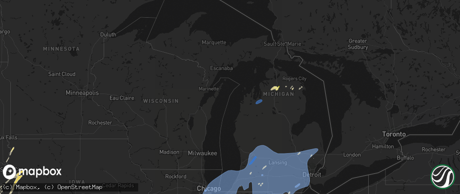
Wind
Hail
Tornado
1,251
Estimated number of impacted properties by a 1.00" hail or larger0
Estimated number of impacted properties by a 1.75" hail or larger0
Estimated number of impacted properties by a 2.50" hail or largerStorm reports in Michigan
Michigan
| Date | Description |
|---|---|
| 05/18/20264:27 PM CDT | Social media photo of healthy tree snapped |
| 05/18/20264:23 PM CDT | Report of trees down near 22 mi and schoenherr rd and 23 mi and schoenherr rd |
| 05/18/20264:19 PM CDT | Report of a large tree down on house and car |
| 05/18/20264:19 PM CDT | Report of tree down on power line |
| 05/18/20264:12 PM CDT | Large tree limb and powerlines down. |
| 05/18/20264:00 PM CDT | Social media photo of a healthy tree snapped |
| 05/18/20263:54 PM CDT | Social media photos of large tree limb down and small tree snapped |
| 05/18/20263:52 PM CDT | Photo of healthy tree snapped near base |
| 05/18/20263:50 PM CDT | Report of 3ft diameter pine tree down |
| 05/18/20263:45 PM CDT | Measured at kptk pontiac airport |
| 05/18/20263:35 PM CDT | Large tree limb down. |
| 05/18/20263:35 PM CDT | Reports of trees and wires down in the county... Especially across northern sections of the county. |
| 05/18/20263:26 PM CDT | Report of 10 to 12 inch tree limbs down |
| 05/18/20263:24 PM CDT | Report of a large tree on home |
| 05/18/20263:24 PM CDT | Report of a tree down |
| 05/18/20263:21 PM CDT | Mulitple large limbs and powerlines down. |
| 05/18/20263:18 PM CDT | Report of multiple trees down near harry brown airport |
| 05/18/20263:18 PM CDT | Large tree limbs down on powerlines. |
| 05/18/20263:17 PM CDT | County dispatch reports tree down. Time estimated via radar. |
| 05/18/20263:17 PM CDT | Measured on a handheld anemometer |
| 05/18/20263:16 PM CDT | Measured at khyx - harry browne airport |
| 05/18/20263:12 PM CDT | Measured at kmbs - mbs international airport |
| 05/18/20263:05 PM CDT | Report of multiple power lines down |
| 05/18/20263:03 PM CDT | Photo of a healthy tree down across road. Estimated 1 ft diameter. |
| 05/18/20263:00 PM CDT | 24 inch diameter healthy tree down |
| 05/18/20262:56 PM CDT | Multiple trees on lines by river rd and shepherd rd. |
| 05/18/20262:50 PM CDT | County dispatch reports numerous trees and wires down across south/southeastern part of county. Time estimated via radar. |
| 05/18/20262:40 PM CDT | County dispatch reports numerous trees and wires down across the county. Time estimated via radar. |
| 05/18/20262:40 PM CDT | Metal rooftop lifted off a body shop building. Also a tree uprooted onto a house in st louis. |
| 05/18/20262:35 PM CDT | Emergency management reports numerous trees and wires down across the county. More concentrated damage across the st louis and pompei areas. Time estimated via radar. |
| 05/18/20262:35 PM CDT | County dispatch reports a barn received significant damage. Time estimated via radar. |
| 05/18/20262:34 PM CDT | Photos show pole barn roof torn off and moved approx 60 yards. Time estimated via radar. |
| 05/18/20262:33 PM CDT | Awos station kamn gratiot community airport. |
| 05/18/20262:30 PM CDT | Measured by personal weather station. Sustained 61 gust 81 mph from approx 190 degree direction. Scattered power outages in the area. |
| 05/18/20262:28 PM CDT | Sporadic trees reported down across the entire county... But particularly in and around adrian. |
| 05/18/20262:25 PM CDT | Three small planes damaged at lansing capital region international airport. Two parked planes were flipped on their side... While one plane was being towed and got flip |
| 05/18/20262:25 PM CDT | County dispatch reports numerous trees and wires down across the county... Especially in st. Johns. Time estimated via radar. |
| 05/18/20262:25 PM CDT | Asos station klan lansing. |
| 05/18/20262:24 PM CDT | Report of large tree limb down on house causing damage to roofing |
| 05/18/20262:23 PM CDT | County dispatch reports numerous trees and wires down across the county including multiple trees on houses. Time estimated via radar. |
| 05/18/20262:19 PM CDT | County dispatch reports numerous trees and wires down across the county. Time estimated via radar. |
| 05/18/20262:19 PM CDT | Cou |
| 05/18/20262:10 PM CDT | Maple tree down and golf cart turned over. |
| 05/18/20262:03 PM CDT | Public report of a barn with significant damage near portland. Time estimated via radar. |
| 05/18/20262:03 PM CDT | One foot healthy diameter tree down. |
| 05/18/20262:03 PM CDT | County dispatch reports numerous trees and wires down across the county. Time estimated via radar. |
| 05/18/20262:01 PM CDT | Roof mounted weather station peak gust. Heavy damage to trees. |
| 05/18/20262:00 PM CDT | Ionia county awos. |
| 05/18/20261:59 PM CDT | County dispatch reports numerous trees and wires down across the county. Time estimated via radar. |
| 05/18/20261:53 PM CDT | 911 dispatch reports numerous trees and wires down across calhoun county including a tree on a house in marshall. Time estimated via radar. |
| 05/18/20261:51 PM CDT | Two trees down by 11 mile rd and young ave. Time approximate. |
| 05/18/20261:50 PM CDT | Estimated winds to 70 mph and some flooding. Reported near correll road and colon road. Time estimated from radar. |
| 05/18/20261:50 PM CDT | Widespread small and medium limb damage. |
| 05/18/20261:50 PM CDT | A local report indicates 59 MPH wind near 1 ENE Woodland |
| 05/18/20261:49 PM CDT | Damage to a roof at a learning center. Time approximate. |
| 05/18/20261:47 PM CDT | Numerous trees down blocking roads between caledonia and lowell... Including peck lake rd at kyser and catch rds. |
| 05/18/20261:45 PM CDT | Mesonet recorded gust. |
| 05/18/20261:44 PM CDT | Battle creek asos. |
| 05/18/20261:42 PM CDT | Gerald r ford international airport asos. |
| 05/18/20261:36 PM CDT | County dispatch reports numerous trees and wires down across the county. Time estimated via radar. |
| 05/18/20261:36 PM CDT | County dispatch reports numerous trees and wires down across the county. Time estimated via radar. |
| 05/18/20261:35 PM CDT | Corrects time of previous tstm wnd dmg report from 4 ne constantine. Emergency manager reports powerlines and power pole down near freese road and roys road to the nort |
| 05/18/20261:34 PM CDT | Tree on house. |
| 05/18/20261:25 PM CDT | Power lines down in florence township. Time estimated from radar. |
| 05/18/20261:20 PM CDT | Kalamazoo asos. |
| 05/18/20261:20 PM CDT | Reporter also notes numerous downed tree limbs. Time estimated via radar. |
| 05/18/20261:19 PM CDT | Large tree branches down near corey lake. Time estimated from radar. |
| 05/18/20261:18 PM CDT | Reports via mping of several tree limbs snapped... Some wires down... And a broken power pole. |
| 05/18/20261:12 PM CDT | Multiple large healthy trees down. Time approximate. |
| 05/18/20261:10 PM CDT | Power out with quite a few branches down. Location approximate. |
| 05/18/20261:10 PM CDT | 911 dispatch reports numerous trees and wires down across southern ottawa county. Time estimated via radar. |
| 05/18/20261:04 PM CDT | Reports of trees downed. Time estimated from radar. |
| 05/18/20261:04 PM CDT | Reports of trees downed. Time estimated from radar. |
| 05/18/20261:01 PM CDT | Emergency management and county dispatch report numerous trees and wires down across allegan county. Time estimated via radar. |
| 05/18/20261:01 PM CDT | Tree down across 44th st by 6th ave. |
| 05/18/20261:00 PM CDT | Large trees downed in vandalia area. Time estimated from radar. |
| 05/18/202612:54 PM CDT | 911 dispatch reports numerous trees and wires down across van buren county. Time estimated via radar. |
| 05/18/202612:50 PM CDT | Damage reported at the edwardsburg little league fields. Two dugout roofs were blown off... Several fences damaged... And some damage to the bleachers. Time estimated v |
| 05/18/202612:48 PM CDT | Large tree downed onto eagle lake road. Time estimated from radar. |
| 05/18/202612:46 PM CDT | Irrigation pivot flipped over. Time estimated from radar. |
| 05/18/202612:41 PM CDT | Mdot station mc099 at south haven. |
| 05/18/202612:35 PM CDT | Emergency manager reports powerlines and power pole down near freese road and roys road to the northeast of constantine in st. Joseph county in michigan. Time estimated |
| 05/18/202612:34 PM CDT | Delayed report. Large tree limbs downed on ferry street. Time estimated from radar. |
| 05/18/202612:25 PM CDT | Asos station kbeh benton harbor. |
All States Impacted by Hail Map on May 18, 2026
Cities Impacted by Hail Map on May 18, 2026
- Nebo, IL
- Kampsville, IL
- Hamburg, IL
- Eldred, IL
- Pearl, IL
- White Hall, IL
- Boelus, NE
- Canton, IL
- Lewistown, IL
- Liverpool, IL
- Topeka, IL
- Havana, IL
- Manito, IL
- Glasford, IL
- Forest City, IL
- Pekin, IL
- Green Valley, IL
- Kingston Mines, IL
- Mapleton, IL
- Peoria, IL
- San Jose, IL
- Mason City, IL
- Easton, IL
- Hartsburg, IL
- New Holland, IL
- South Pekin, IL
- Emden, IL
- Delavan, IL
- Roanoke, IL
- Clinton, IL
- Waynesville, IL
- Wapella, IL
- Dewitt, IL
- Farmer City, IL
- Le Roy, IL
- Taylorville, IL
- Palmer, IL
- Centralia, IL
- Odin, IL
- Salem, IL
- Morris, IL
- Minooka, IL
- Catawissa, MO
- Robertsville, MO
- Pacific, MO
- Cedar Hill, MO
- House Springs, MO
- Collinsville, IL
- Imperial, MO
- Fenton, MO
- New Lenox, IL
- Mokena, IL
- Oak Lawn, IL
- Chicago Ridge, IL
- Tinley Park, IL
- Hometown, IL
- Orland Park, IL
- Alsip, IL
- Evergreen Park, IL
- Chicago, IL
- Palos Heights, IL
- Palos Park, IL
- Bridgeview, IL
- Palos Hills, IL
- Worth, IL
- Burbank, IL
- Cicero, IL
- Riverside, IL
- Hickory Hills, IL
- La Grange, IL
- Justice, IL
- Berwyn, IL
- Summit Argo, IL
- Lyons, IL
- Willow Springs, IL
- Oak Park, IL
- Highland, IN
- Calumet City, IL
- Markham, IL
- Midlothian, IL
- Dolton, IL
- Country Club Hills, IL
- Gary, IN
- Homewood, IL
- Whiting, IN
- Thornton, IL
- Frankfort, IL
- Munster, IN
- Olympia Fields, IL
- Flossmoor, IL
- Hazel Crest, IL
- Chicago Heights, IL
- South Holland, IL
- East Chicago, IN
- Oak Forest, IL
- Harvey, IL
- Hammond, IN
- Crestwood, IL
- Robbins, IL
- Matteson, IL
- Glenwood, IL
- Lansing, IL
- Blue Island, IL
- Posen, IL
- Riverdale, IL
- Homer Glen, IL
- Griffith, IN
- Park Forest, IL
- Steger, IL
- Richton Park, IL
- University Park, IL
- Monee, IL
- Arnold, MO
- Saint Louis, MO
- Schererville, IN
- Dyer, IN
- Saint John, IN
- Crete, IL
- Merrillville, IN
- Cedar Lake, IN
- Lowell, IN
- Crown Point, IN
- Momence, IL
- Grant Park, IL
- Bradley, IL
- Bourbonnais, IL
- Pembroke Township, IL
- Manteno, IL
- Saint Anne, IL
- Kankakee, IL
- Beecher, IL
- Aroma Park, IL
- Chebanse, IL
- Lake Village, IN
- Schneider, IN
- Hebron, IN
- Hobart, IN
- Lake Station, IN
- Portage, IN
- Valparaiso, IN
- Westville, IN
- Chesterton, IN
- Union Mills, IN
- Wanatah, IN
- Kouts, IN
- Boone Grove, IN
- Kingsford Heights, IN
- La Porte, IN
- Hamlet, IN
- Michigan City, IN
- La Crosse, IN
- Hanna, IN
- Knox, IN
- Beverly Shores, IN
- Noel, MO
- New Buffalo, MI
- Lakeside, MI
- Rolling Prairie, IN
- Union Pier, MI
- Three Oaks, MI
- Bridgman, MI
- Sawyer, MI
- Walkerton, IN
- Mill Creek, IN
- Harbert, MI
- New Carlisle, IN
- Galien, MI
- New Troy, MI
- Baroda, MI
- Stevensville, MI
- Buchanan, MI
- North Liberty, IN
- Grovertown, IN
- South Bend, IN
- Saint Joseph, MI
- Berrien Springs, MI
- Niles, MI
- Clay City, IN
- Centerpoint, IN
- Benton Harbor, MI
- Sodus, MI
- Coloma, MI
- Eau Claire, MI
- Berrien Center, MI
- Notre Dame, IN
- Liberal, MO
- Granger, IN
- Mishawaka, IN
- Louisburg, MO
- Urbana, MO
- Half Way, MO
- Dowagiac, MI
- Watervliet, MI
- Bangor, MI
- Decatur, MI
- Covert, MI
- Hartford, MI
- South Haven, MI
- Edwardsburg, MI
- Cassopolis, MI
- Bourbon, IN
- Mentone, IN
- Tippecanoe, IN
- Rochester, IN
- Akron, IN
- Claypool, IN
- Etna Green, IN
- Warsaw, IN
- Lawton, MI
- Lawrence, MI
- Marcellus, MI
- Paw Paw, MI
- Vandalia, MI
- Kingsley, MI
- Traverse City, MI
- Williamsburg, MI
- South Boardman, MI
- Kalkaska, MI
- Grand Junction, MI
- Allegan, MI
- Bloomingdale, MI
- Pullman, MI
- Fennville, MI
- Leesburg, IN
- Atwood, IN
- Gobles, MI
- Jones, MI
- Schoolcraft, MI
- Mattawan, MI
- Kalamazoo, MI
- Simpson, KS
- Vanderbilt, MI
- Elmira, MI
- Hamilton, MI
- Otsego, MI
- Hopkins, MI
- Marco Island, FL
- Jamestown, KS
- Gaylord, MI
- Dorr, MI
- Martin, MI
- Shelbyville, MI
- Wayland, MI
- Wilson, KS
- Sylvan Grove, KS
- Ashmore, IL
- Concordia, KS
- Scandia, KS
- Norway, KS
- Bolivar, MO
- Aldrich, MO
- Walnut Grove, MO
- Morrisville, MO
- Plainwell, MI
- Portage, MI
- Vicksburg, MI
- Lincoln, KS
- Hastings, MI
- Claflin, KS
- Mendon, MI
- Leonidas, MI
- Milan, MI
- Colon, MI
- Sherwood, MI
- Richland, MI
- Grandville, MI
- Rockford, MI
- Grand Rapids, MI
- Caledonia, MI
- Belmont, MI
- Wyoming, MI
- Byron Center, MI
- Cedar Springs, MI
- Middleville, MI
- Ada, MI
- Comstock Park, MI
- Hudsonville, MI
- Allendale, MI
- Zeeland, MI
- Marne, MI
- Jenison, MI
- Lake Odessa, MI
- Dowling, MI
- Climax, MI
- Ceresco, MI
- Galesburg, MI
- Bellevue, MI
- Scotts, MI
- Lowell, MI
- Augusta, MI
- Freeport, MI
- Nashville, MI
- Delton, MI
- Alto, MI
- Battle Creek, MI
- Hickory Corners, MI
- East Leroy, MI
- Clarksville, MI
- Marshall, MI
- Holyrood, KS
- Hebron, NE
- Deshler, NE
- Washington, KS
- Fenwick, MI
- Saranac, MI
- Olivet, MI
- Sheridan, MI
- Sidney, MI
- Gowen, MI
- Woodland, MI
- Vermontville, MI
- Stanton, MI
- Greenville, MI
- Orleans, MI
- Ionia, MI
- Belding, MI
- Sand Lake, MI
- Trufant, MI
- Homer, MI
- Albion, MI
- Charlotte, MI
- Sunfield, MI
- Tekonsha, MI
- Burlington, MI
- Coldwater, MI
- Kendallville, IN
- Howe, IN
- Athens, MI
- Auburn, IN
- Pleasant Lake, IN
- Lagrange, IN
- Huntertown, IN
- Angola, IN
- Hudson, IN
- Bronson, MI
- Avilla, IN
- Garrett, IN
- Fremont, IN
- Fort Wayne, IN
- Corunna, IN
- Quincy, MI
- Laotto, IN
- Ashley, IN
- Wolcottville, IN
- Union City, MI
- Orland, IN
- Waterloo, IN
- Montgomery, MI
- New Haven, IN
- Antwerp, OH
- Harlan, IN
- Convoy, OH
- Saint Joe, IN
- Leo, IN
- Reading, MI
- Hamilton, IN
- Spencerville, IN
- Hoagland, IN
- Woodburn, IN
- Hicksville, OH
- Grabill, IN
- Monroeville, IN
- Butler, IN
- Payne, OH
- Edon, OH
- Paulding, OH
- Scott, OH
- Cecil, OH
- Montpelier, OH
- Haviland, OH
- Defiance, OH
- Grover Hill, OH
- Bryan, OH
- Litchfield, MI
- Mark Center, OH
- Fort Jennings, OH
- Camden, MI
- Van Wert, OH
- Ney, OH
- Ottoville, OH
- Hillsdale, MI
- Oakwood, OH
- Melrose, OH
- Pioneer, OH
- Sherwood, OH
- Latty, OH
- Cloverdale, OH
- Edgerton, OH
- Allen, MI
- Middle Point, OH
- Willis, MI
- Rome City, IN
- Burr Oak, MI
- Albion, IN
- Arcola, IN
- South Milford, IN
- Churubusco, IN
- Fulton, MI
- Sturgis, MI
- Three Rivers, MI
- Centreville, MI
- Wawaka, IN
- Columbia City, IN
- Kimmell, IN
- Topeka, IN
- Shipshewana, IN
- Goshen, IN
- Millersburg, IN
- Constantine, MI
- Middlebury, IN
- Ligonier, IN
- White Pigeon, MI
- Belvidere, NE
- Hollenberg, KS
- Morrowville, KS
- Belleville, KS
- Barnard, KS
- Haddam, KS
- Cromwell, IN
- Mahaska, KS
- Pierceton, IN
- Larwill, IN
- Zionsville, IN
- Sheridan, IN
- Westfield, IN
- Carleton, NE
- Beloit, KS
- Stryker, OH
- Archbold, OH
- Evansport, OH
- Endicott, NE
- Steele City, NE
- Diller, NE
- Lyons, OH
- Hillman, MI
- Lyons, MI
- Portland, MI
- Agenda, KS
- Mulliken, MI
- Atlanta, MI
- Clifton, KS
- Napoleon, OH
- Minneapolis, KS
- Eaton Rapids, MI
- West Unity, OH
- Concord, MI
- Muir, MI
- Springport, MI
- Hanover, MI
- Grand Ledge, MI
- Osseo, MI
- Jonesville, MI
- Carson City, MI
- Onondaga, MI
- Dimondale, MI
- Okemos, MI
- Spring Arbor, MI
- Eagle, MI
- Clarklake, MI
- Fowler, MI
- Rives Junction, MI
- Parma, MI
- Jerome, MI
- Haslett, MI
- Potterville, MI
- North Adams, MI
- Horton, MI
- East Lansing, MI
- Hubbardston, MI
- Jackson, MI
- Westphalia, MI
- Saint Johns, MI
- Bath, MI
- Dewitt, MI
- Laingsburg, MI
- Lansing, MI
- Pewamo, MI
- Alvordton, OH
- Pittsford, MI
- Waldron, MI
- Mason, MI
- Holt, MI
- Leslie, MI
- Jasper, MI
- Fairbury, NE
- Cuba, KS
- Lachine, MI
- Fort Stockton, TX
- Delphos, KS
- Beverly, KS
- Iraan, TX
- Glasco, KS
- Jansen, NE
- Beatrice, NE
- Odell, NE
- Delta, OH
- Alpena, MI
- Narka, KS
- Blue Springs, NE
- Aurora, KS
- Miltonvale, KS
- Eldridge, MO
- Dixon, MO
- Meta, MO
- Brinktown, MO
- Camdenton, MO
- Linn Creek, MO
- Clyde, KS
- Filley, NE
- Burton, MI
- Flint, MI
- Lorraine, KS
- Wymore, NE
- Mathias, WV
- Baker, WV
- Tescott, KS
- Pickrell, NE
- Adams, NE
- Crab Orchard, NE
- Tecumseh, NE
- Offerle, KS
- Davison, MI
- Spearville, KS
- Kinsley, KS
- Mount Vernon, IN
- Virginia, NE
- Kanopolis, KS
- Ellsworth, KS
- Morganville, KS
- Bucklin, KS
- Schuyler, NE
- Bee, NE
- Valparaiso, NE
- Howells, NE
- Clarkson, NE
- Lewis, KS
- Sterling, NE
- Steinauer, NE
- Leigh, NE
- Lewiston, NE
- Garfield, KS
- Larned, KS
- Fairmont, NE
- Ford, KS
- De Witt, NE
- Brookville, KS
- Clay Center, KS
- Hanover, KS
- Wisner, NE
- Pilger, NE
- Stanton, NE
- Liberty, NE
- Burchard, NE
- Pawnee City, NE
- Wright, KS
- Dodge City, KS
- Beemer, NE
- Dodge, NE
- West Point, NE
- Ortonville, MI
- Hamburg, MI
- White Lake, MI
- Grand Blanc, MI
- Hadley, MI
- Bancroft, MI
- Linden, MI
- Brighton, MI
- Swartz Creek, MI
- Perry, MI
- Davisburg, MI
- Stockbridge, MI
- Clarkston, MI
- Highland, MI
- Norvell, MI
- Lapeer, MI
- Pleasant Lake, MI
- Gaines, MI
- Whitmore Lake, MI
- Grass Lake, MI
- Hudson, MI
- Webberville, MI
- Hartland, MI
- Napoleon, MI
- Clayton, MI
- Byron, MI
- Gregory, MI
- Munith, MI
- Goodrich, MI
- Dexter, MI
- Cement City, MI
- Michigan Center, MI
- Somerset Center, MI
- Manitou Beach, MI
- Dansville, MI
- Williamston, MI
- Pinckney, MI
- Howell, MI
- Milford, MI
- Attica, MI
- Adrian, MI
- Addison, MI
- Atlas, MI
- Fenton, MI
- Morrice, MI
- Owosso, MI
- Manchester, MI
- Ann Arbor, MI
- Durand, MI
- Fowlerville, MI
- Tipton, MI
- Onsted, MI
- Chelsea, MI
- Lennon, MI
- Metamora, MI
- Holly, MI
- Brooklyn, MI
- Beattie, KS
- Cook, NE
- Elk Creek, NE
- Burr, NE
- Table Rock, NE
- Auburn, NE
- Humboldt, NE
- Brock, NE
- Johnson, NE
- Vernon, MI
- Ovid, MI
- Corunna, MI
- Elsie, MI
- Columbiaville, MI
- Flushing, MI
- Du Bois, NE
- Talmage, NE
- Dawson, NE
- Stella, NE
- Staplehurst, NE
- Seward, NE
- Superior, NE
- Summerfield, KS
- Home, KS
- Weston, NE
- Dwight, NE
- Salina, KS
- McCool Junction, NE
- Waco, NE
- York, NE
- Oketo, KS
- Star Tannery, VA
- Clinton, MI
- Northville, MI
- Sand Creek, MI
- Wixom, MI
- New Hudson, MI
- Morenci, MI
- Tecumseh, MI
- Commerce Township, MI
- Fayette, OH
- Saline, MI
- Waterford, MI
- Britton, MI
- Palmyra, MI
- South Lyon, MI
- Oxford, MI
- Oak, NE
- Davenport, NE
- Livonia, MI
- Plymouth, MI
- Oakland, MI
- Dearborn Heights, MI
- Canton, MI
- Farmington, MI
- Blissfield, MI
- Newport, MI
- Detroit, MI
- Southfield, MI
- Westland, MI
- Pontiac, MI
- Redford, MI
- Taylor, MI
- Rockwood, MI
- Lake Orion, MI
- Dryden, MI
- Maybee, MI
- Petersburg, MI
- Keego Harbor, MI
- Auburn Hills, MI
- Birmingham, MI
- Carleton, MI
- Dearborn, MI
- Monroe, MI
- Rochester, MI
- Inkster, MI
- Ida, MI
- Garden City, MI
- Flat Rock, MI
- Romulus, MI
- West Bloomfield, MI
- Ypsilanti, MI
- Franklin, MI
- Novi, MI
- Wayne, MI
- Dundee, MI
- Belleville, MI
- Bloomfield Hills, MI
- Deerfield, MI
- Walled Lake, MI
- South Rockwood, MI
- New Boston, MI
- Nelson, NE
- Greenleaf, KS
- Palmer, KS
- Winchester, VA
- Strasburg, VA
- Courtland, KS
- Hubbell, NE
- Munden, KS
- Morse Bluff, NE
- Cedar Bluffs, NE
- Almont, MI
- Lindsborg, KS
- Brainard, NE
- David City, NE
- North Bend, NE
- Prague, NE
- Malmo, NE
- Bennington, KS
- Metamora, OH
- Riga, MI
- Ames, NE
- Ruskin, NE
- Ottawa Lake, MI
- Berkey, OH
- Surprise, NE
- Quanah, TX
- Swanton, OH
- Ulysses, NE
- Chester, NE
- Bancroft, NE
- Pender, NE
- Gresham, NE
- Falun, KS
- Bruno, NE
- Shickley, NE
- Eldorado, OK
- Gould, OK
- Duke, OK
- Bern, KS
- Sabetha, KS
- Brownville, NE
- Peru, NE
- Julian, NE
- Walthill, NE
- Solomon, KS
- Rising City, NE
- Strang, NE
- Bruning, NE
- Green, KS
- Hooper, NE
- Winslow, NE
- Fremont, NE
- Stephens City, VA
- Middletown, VA
- Geneva, NE
- Reynolds, NE
- Nebraska City, NE
- Rock Port, MO
- Linwood, NE
- La Salle, MI
- Shubert, NE
- Watson, MO
- Nemaha, NE
- Temperance, MI
- Ohiowa, NE
- Tobias, NE
- Milligan, NE
- River Rouge, MI
- Imlay City, MI
- Sterling Heights, MI
- Ferndale, MI
- Washington, MI
- Ecorse, MI
- Trenton, MI
- Romeo, MI
- Madison Heights, MI
- Pleasant Ridge, MI
- Royal Oak, MI
- Highland Park, MI
- Wyandotte, MI
- Grosse Ile, MI
- Lincoln Park, MI
- Warren, MI
- Hazel Park, MI
- Southgate, MI
- Utica, MI
- Center Line, MI
- Melvindale, MI
- Huntington Woods, MI
- Leonard, MI
- Riverview, MI
- Oak Park, MI
- Clawson, MI
- Hamtramck, MI
- Allen Park, MI
- Berkley, MI
- Troy, MI
- Coldwater, KS
- Belpre, KS
- St John, KS
- Hamburg, IA
- Alexandria, NE
- Herman, NE
- Craig, NE
- Tekamah, NE
- Oakland, NE
- Bellwood, NE
- Macksville, KS
- Columbus, NE
- Abilene, KS
- New Cambria, KS
- Longford, KS
- Hudson, KS
- Gerrardstown, WV
- Rogers, NE
- Verdon, NE
- Farragut, IA
- Riverton, IA
- Northboro, IA
- Shenandoah, IA
- Creston, NE
- Newburg, MO
- Duke, MO
- Hawarden, IA
- Hornick, IA
- Salix, IA
- Bronson, IA
- Sloan, IA
- Winnebago, NE
- Assaria, KS
- Onawa, IA
- Whiting, IA
- Decatur, NE
- Friend, NE
- Westboro, MO
- Barnes, KS
- Gypsum, KS
- Linn, KS
- Waterville, KS
- Western, NE
- Daykin, NE
- Tarkio, MO
- Marysville, KS
- Wakefield, KS
- Capac, MI
- Emmett, MI
- Allenton, MI
- Yale, MI
- Scribner, NE
- Dorchester, NE
- Greensburg, KS
- Akron, IA
- Westfield, IA
- Hastings, IA
- Emerson, IA
- Brown City, MI
- Melvin, MI
- Avoca, MI
- Coin, IA
- Randolph, KS
- Falls City, NE
- Crete, NE
- Pleasant Dale, NE
- Milford, NE
- Denton, NE
- Mangum, OK
- Haviland, KS
- Raymond, KS
- Alden, KS
- Sylvia, KS
- Rock Valley, IA
- Exeter, NE
- Climbing Hill, IA
- Smithland, IA
- Correctionville, IA
- Anthon, IA
- Moville, IA
- Oto, IA
- Lyons, NE
- Blanchard, IA
- Snyder, NE
- Stafford, KS
- Talmage, KS
- Red Oak, IA
- Armada, MI
- Sterling, KS
- Ellinwood, KS
- Byers, KS
- Blue Rapids, KS
- Rodney, IA
- Fairfax, MO
- Beaver Crossing, NE
- Carter, OK
- Dill City, OK
- Elk City, OK
- Quimby, IA
- Washta, IA
- Pierson, IA
- Holstein, IA
- Cushing, IA
- Macy, NE
- Uehling, NE
- Cherokee, IA
- Aurelia, IA
- Wayne, NE
- Clarinda, IA
- Elmo, MO
- Wakefield, NE
- College Springs, IA
- Utica, NE
- Goehner, NE
- Lyons, KS
- Chase, KS
- Plevna, KS
- Junction City, KS
- Milford, KS
- Chapman, KS
- Elliott, IA
- Griswold, IA
- Rosalie, NE
- Syracuse, NE
- Alton, IA
- Hospers, IA
- Gilead, NE
- Garland, NE
- Braddyville, IA
- Kingsley, IA
- Shambaugh, IA
- Clearmont, MO
- Burlington Junction, MO
- New Market, IA
- Abbyville, KS
- Bedford, IA
- Partridge, KS
- Hutchinson, KS
- Nickerson, KS
- Inman, KS
- South Hutchinson, KS
- Allen, NE
- Concord, NE
- Ceresco, NE
- Unadilla, NE
- Douglas, NE
- Riley, KS
- Iuka, KS
- Canute, OK
- Pratt, KS
- Frankfort, KS
- Leonardville, KS
- Junction, IL
- Turon, KS
- Sullivan, MO
- Craig, MO
- Dixon, NE
- Little River, KS
- Shawneetown, IL
- Enterprise, KS
- Arlington, KS
- Buhler, KS
- Haven, KS
- Sanborn, IA
- Ponca, NE
- Waterbury, NE
- Corning, IA
- Cumberland, IA
- Sheldon, IA
- Hope, KS
- Fort Riley, KS
- Skidmore, MO
- Wiota, IA
- Sidney, IA
- Archer, IA
- Wahoo, NE
- Windom, KS
- Ocheyedan, IA
- Harris, IA
- Union, NE
- Mcpherson, KS
- Massena, IA
- Sturgis, KY
- Vermillion, KS
- Dunbar, NE
- Morganfield, KY
- Hartley, IA
- Matthews, MO
- Weeping Water, NE
- Avoca, NE
- Butler, OK
- Hopkins, MO
- Axtell, KS
- Lonedell, MO
- Richwoods, MO
- Otoe, NE
- Burrton, KS
- Raymond, NE
- Plymouth, NE
- Elk Point, SD
- Redding, IA
- Sheridan, MO
- Clearfield, IA
- Pickering, MO
- Gravity, IA
- Blockton, IA
- Bridgewater, IA
- Randolph, IA
- Lake Park, IA
- Wilber, NE
- Swanton, NE
- Bertrand, MO
- Lincoln, NE
- Ogden, KS
- Maryville, MO
- Nehawka, NE
- Manhattan, KS
- Woodbine, KS
- Baileyville, KS
- Jefferson, SD
- Marianna, AR
- Seneca, KS
- Uniontown, KY
- Colon, NE
- Fort Calhoun, NE
- Omaha, NE
- Parnell, MO
- Moundridge, KS
- Prescott, IA
- Fontanelle, IA
- Canton, KS
- Galva, KS
- Westmoreland, KS
- Saint George, KS
- Oneida, KS
- Olsburg, KS
- Ong, NE
- Miller City, IL
- Plattsmouth, NE
- Greenfield, IA
- Spirit Lake, IA
- Milford, IA
- Murray, NE
- Malvern, IA
- Tabor, IA
- Glenwood, IA
- Benton, IA
- Grant City, MO
- Ithaca, NE
- Armstrong, IA
- Swea City, IA
- Wamego, KS
- Alma, KS
- Cairo, IL
- Mounds, IL
- Davey, NE
- Onaga, KS
- Herington, KS
- Pretty Prairie, KS
- Waverly, NE
- Centralia, KS
- Durham, KS
- Clatonia, NE
- Earlham, IA
- Bennington, NE
- Dwight, KS
- Alta Vista, KS
- Halstead, KS
- White City, KS
- Hillsboro, KS
- Hesston, KS
- Ledyard, IA
- Havensville, KS
- Corning, KS
- Goff, KS
- Soldier, KS
- Edgar, NE
- Cunningham, KS
- Diagonal, IA
- Blue Earth, MN
- Ashland, NE
- Greenwood, NE
- Salem, NE
- Newton, KS
- Goessel, KS
- Marion, KS
- Afton, IA
- Thayer, IA
- Shannon City, IA
- Ellston, IA
- Tingley, IA
- Mount Ayr, IA
- Persia, IA
- Neola, IA
- Logan, IA
- Ramona, KS
- Lincolnville, KS
- Tampa, KS
- Lost Springs, KS
- Elkhorn, NE
- Missouri Valley, IA
- Honey Creek, IA
- Van Meter, IA
- Winterset, IA
- De Soto, IA
- Belvue, KS
- Mount Hope, KS
- Bremen, KS
- Circleville, KS
- Holton, KS
- Portsmouth, IA
- Emmett, KS
- Saint Marys, KS
- Paxico, KS
- Delia, KS
- Fairview, KS
- Hiawatha, KS
- Blanchard, PA
- Beech Creek, PA
- Howard, PA
- Sedgwick, KS
- Burdick, KS
- Wilsey, KS
- Council Grove, KS
- Walton, KS
- Peabody, KS
- Isabel, KS
- Sun City, KS
- Coats, KS
- Percival, IA
- Prole, IA
- Ida Grove, IA
- Battle Creek, IA
- Mayetta, KS
- Cumming, IA
- West Des Moines, IA
- Norwalk, IA
- Netawaka, KS
- Sawyer, KS
- Wetmore, KS
- Strong City, KS
- Whiting, KS
- Rossville, KS
- Eskridge, KS
- Maple Hill, KS
- Topeka, KS
- McFarland, KS
- Harveyville, KS
- Allen, KS
- Kellerton, IA
- Hatfield, MO
- Grand River, IA
- Americus, KS
- Silver Lake, KS
- White Cloud, KS
- Robinson, KS
- Rulo, NE
- Horton, KS
- Powhattan, KS
- Muscotah, KS
- Kingman, KS
- North Newton, KS
- Nashville, KS
- Cedar Point, KS
- Indianola, IA
- Colwich, KS
- Lancaster, KS
- Everest, KS
- Denison, KS
- Carbondale, KS
- Burlingame, KS
- Reading, KS
- Hoyt, KS
- Wakarusa, KS
- Auburn, KS
- Mound City, MO
- Maitland, MO
- Oregon, MO
- Valley Falls, KS
- Spivey, KS
- Florence, KS
- Elmdale, KS
- Denton, KS
- Effingham, KS
- Highland, KS
- Forest City, MO
- Bendena, KS
- Troy, KS
- Andale, KS
- Zenda, KS
- Bentley, KS
- Ravenwood, MO
- Valley Center, KS
- Meriden, KS
- Berryton, KS
- Atchison, KS
- Wathena, KS
- Saint Joseph, MO
- Elwood, KS
- Cottonwood Falls, KS
- Amazonia, MO
- Fillmore, MO
- Savannah, MO
- Admire, KS
- Emporia, KS
- Bolckow, MO
- Graham, MO
- Barnard, MO
- Scranton, KS
- Nortonville, KS
- Matfield Green, KS
- Burns, KS
- Union Star, MO
- Osage City, KS
- Cosby, MO
- Helena, MO
- Whitewater, KS
- Isanti, MN
- Saint Francis, MN
- Zimmerman, MN
- Rea, MO
- Rosendale, MO
- State Center, IA
- Worth, MO
- Potwin, KS
- Murdock, KS
- Cheney, KS
- Garden Plain, KS
- Tecumseh, KS
- Grantville, KS
- Quenemo, KS
- Overbrook, KS
- Cummings, KS
- King City, MO
- Winchester, KS
- Attica, KS
- McLouth, KS
- El Dorado, KS
- Cassoday, KS
- Oskaloosa, KS
- Ozawkie, KS
- Lawrence, KS
- Lecompton, KS
- Perry, KS
- Easton, KS
- Leavenworth, KS
- Tonganoxie, KS
- Eudora, KS
- Baldwin City, KS
- Lansing, KS
- Pomona, KS
- Bonner Springs, KS
- Ottawa, KS
- De Soto, KS
- Linwood, KS
- Basehor, KS
- Wellsville, KS
- Conception Junction, MO
- Stanberry, MO
- Albany, MO
- Martinsville, MO
- Eagleville, MO
- Ridgeway, MO
- Denver, MO
- New Hampton, MO
- Bethany, MO
- Gentry, MO
- Clyde, MO
- Conception, MO
- Darlington, MO
- Lamoni, IA
- Davis City, IA
- Cainsville, MO
- Blythedale, MO
- Decatur, IA
- Leon, IA
- Gilman City, MO
- Chatsworth, IA
- Princeton, MO
- Wichita, KS
- Maize, KS
- Goddard, KS
- Haysville, KS
- Clearwater, KS
- Jamesport, MO
- Shawnee, KS
- Gardner, KS
- Paola, KS
- Spring Hill, KS
- Edgerton, KS
- New Century, KS
- Olathe, KS
- Platte City, MO
- Rantoul, KS
- Lenexa, KS
- Kansas City, KS
- Harper, KS
- Olpe, KS
- Amity, MO
- Maysville, MO
- Clarksdale, MO
- Pattonsburg, MO
- McFall, MO
- Weatherby, MO
- Coffey, MO
- Jameson, MO
- Kechi, KS
- Mcconnell Afb, KS
- Derby, KS
- Mercer, MO
- Spickard, MO
- Lineville, IA
- Osceola, IA
- Garden Grove, IA
- Weldon, IA
- Van Wert, IA
- Murray, IA
- Humeston, IA
- Trenton, MO
- Madison, KS
- Chariton, IA
- Norwich, KS
- Eureka, KS
- Mondovi, WI
- Easton, MO
- Stewartsville, MO
- Altamont, MO
- Winston, MO
- Gallatin, MO
- Cameron, MO
- Osborn, MO
- Stilwell, KS
- Independence, MO
- Waldron, MO
- Farley, MO
- Liberty, MO
- Bucyrus, KS
- Overland Park, KS
- Prairie Village, KS
- Kansas City, MO
- Mission, KS
- Leawood, KS
- Riverside, MO
- Louisburg, KS
- Rose Hill, KS
- Greenwich, KS
- Towanda, KS
- Andover, KS
- Benton, KS
- Hartford, KS
- Gridley, KS
- Neosho Rapids, KS
- Burlington, KS
- Lebo, KS
- Waverly, KS
- Smithville, MO
- Kearney, MO
- Holt, MO
- Excelsior Springs, MO
- Corydon, IA
- Woodburn, IA
- Allerton, IA
- Clio, IA
- Derby, IA
- Lucas, IA
- Lucerne, MO
- Seymour, IA
- Powersville, MO
- Augusta, KS
- Douglass, KS
- Brooklyn, IA
- Eleva, WI
- Milton, KS
- Plattsburg, MO
- Orrick, MO
- Rayville, MO
- Conway Springs, KS
- Argonia, KS
- Anthony, KS
- Danville, KS
- Viola, KS
- Cleveland, MO
- Blue Springs, MO
- Freeman, MO
- Pleasant Hill, MO
- Missouri City, MO
- Grandview, MO
- Lees Summit, MO
- Peculiar, MO
- Belton, MO
- Raymore, MO
- Harrisonville, MO
- Greenwood, MO
- Oak Grove, MO
- Richmond, MO
- Levasy, MO
- Lawson, MO
- Buckner, MO
- Grain Valley, MO
- Sibley, MO
- Leon, KS
- Rosalia, KS
- Westphalia, KS
- Le Roy, KS
- Unionville, MO
- Promise City, IA
- Millerton, IA
- Russell, IA
- Plano, IA
- Melrose, IA
- Centerville, IA
- Moravia, IA
- Mystic, IA
- Laredo, MO
- Chula, MO
- Chillicothe, MO
- Galt, MO
- Milan, MO
- Humphreys, MO
- Harris, MO
- Browning, MO
- Hamilton, KS
- Milan, KS
- Henrietta, MO
- Hardin, MO
- Camden, MO
- Bates City, MO
- Napoleon, MO
- Odessa, MO
- Wellington, MO
- Lone Jack, MO
- Kingsville, MO
- Lexington, MO
- Dover, MO
- Higginsville, MO
- Holden, MO
- Norborne, MO
- Carrollton, MO
- Mayview, MO
- East Lynne, MO
- Waverly, MO
- Garden City, MO
- Strasburg, MO
- Centerview, MO
- Corder, MO
- Pollock, MO
- Newtown, MO
- Green City, MO
- Warrens, WI
- Black River Falls, WI
- Freeport, KS
- Mayfield, KS
- Wellington, KS
- Virgil, KS
- Peck, KS
- Caldwell, KS
- Laredo, TX
- Belle Plaine, KS
- Mulvane, KS
- Yates Center, KS
- Concordia, MO
- Urich, MO
- Blairstown, MO
- Warrensburg, MO
- Chilhowee, MO
- Creighton, MO
- Leeton, MO
- Knob Noster, MO
- Alma, MO
- Malta Bend, MO
- Udall, KS
- Windsor, MO
- La Monte, MO
- Whiteman Air Force Base, MO
- Sedalia, MO
- Green Ridge, MO
- Calhoun, MO
- Clinton, MO
- Princeton, KS
- Welda, KS
- Richmond, KS
- Garnett, KS
- Colony, KS
- Williamsburg, KS
- South Haven, KS
- Osawatomie, KS
- Greeley, KS
- Lane, KS
- Kincaid, KS
- Montfort, WI
- Cobb, WI
- Friendship, WI
- Arkdale, WI
- Oxford, KS
- Medford, OK
- Ionia, MO
- Lincoln, MO
- Centerville, KS
- Parker, KS
- Fontana, KS
- La Cygne, KS
- Nekoosa, WI
- Atlanta, KS
- Salisbury, MO
- Clifton Hill, MO
- Latham, KS
- Braman, OK
- Cantril, IA
- Piedmont, KS
- Encinal, TX
- Geuda Springs, KS
- Keosauqua, IA
- Burden, KS
- Winfield, KS
- Arkansas City, KS
- Blackwell, OK
- Newkirk, OK
- Ponca City, OK
- Howard, KS
- Grenola, KS
- Bonaparte, IA
- Nardin, OK
- La Belle, MO
- Knox City, MO
- Severy, KS
- Freer, TX
- Realitos, TX
- Cotulla, TX
- Tilden, TX
- Hillsboro, IA
- Farmington, IA
- Rock, KS
- Hunter, OK
- Dexter, KS
- Maple City, KS
- Cambridge, KS
- Lamont, OK
- Cheyenne, OK
- Sayre, OK
- Kaw City, OK
- Cedar Vale, KS
- Wever, IA
- Dallas City, IL
- Fort Madison, IA
- Burbank, OK
- Shidler, OK
- Sedan, KS
- Elk Falls, KS
- Longton, KS
- Moline, KS
- Concepcion, TX
- San Diego, TX
- Oilton, TX
- Mirando City, TX
- Bruni, TX
- Tonkawa, OK
- Benavides, TX
- Clinton, OK
- Hammon, OK
- Odem, TX
- Sinton, TX
- Macomb, IL
- Pawhuska, OK
- Elk City, KS
- Peru, KS
- Alice, TX
- Orange Grove, TX
- Foss, OK
- Robstown, TX
- Agua Dulce, TX
- Bishop, TX
- Mathis, TX
- Taft, TX
- Woodsboro, TX
- Sandia, TX
- Welch, OK
- Nowata, OK
- Gonzales, TX
- Harwood, TX
- Waelder, TX
- Bluejacket, OK
- Miami, OK
- Ingleside, TX
- Haskell, OK
- Bixby, OK
- Coweta, OK
- Broken Arrow, OK
- Council Hill, OK
- Vinita, OK
- Morrill, KS
- Guilford, MO
- Alma, MI
- Ashley, MI
- Ithaca, MI
- Elwell, MI
- Middleton, MI
- Crystal, MI
- Maple Rapids, MI
- Sumner, MI
- Perrinton, MI
- Riverdale, MI
- Pompeii, MI
- North Star, MI
- Brant, MI
- Bannister, MI
- Saint Louis, MI
- Wheeler, MI
- Breckenridge, MI
- Henderson, MI
- Merrill, MI
- Montrose, MI
- New Lothrop, MI
- Chesaning, MI
- Burt, MI
- Mount Morris, MI
- Oakley, MI
- Saginaw, MI
- Hemlock, MI
- Saint Charles, MI
- Otisville, MI
- Genesee, MI
- Frankenmuth, MI
- North Branch, MI
- Birch Run, MI
- Vassar, MI
- Midland, MI
- Clio, MI
- Munger, MI
- Otter Lake, MI
- Bay City, MI
- University Center, MI
- Fostoria, MI
- Millington, MI
- Auburn, MI
- Freeland, MI
- Bridgeport, MI
- Carrollton, MI
- Reese, MI
- Kawkawlin, MI
- Litchfield, IL
- Butler, IL
- Linwood, MI
- Mayville, MI
- Essexville, MI
- Fairgrove, MI
- Akron, MI
- Caro, MI
- Silverwood, MI
- Sebewaing, MI
- Unionville, MI
- Tremont, IL
- Virginia, IL
- Ashland, IL
- Kingston, MI
- Cass City, MI
- Deford, MI
- Clifford, MI
- Stendal, IN
- Huntingburg, IN
- Velpen, IN
- Winslow, IN
- Holland, IN
- Marlette, MI
- Jasper, IN
- Dubois, IN
- Saint Anthony, IN
- French Lick, IN
- Celestine, IN
- Birdseye, IN
- Schnellville, IN
- Eckerty, IN
- English, IN
- Paoli, IN
- Taswell, IN
- Hardinsburg, IN
- Orleans, IN
- Campbellsburg, IN
- Salem, IN
- Decker, MI
- Mill Hall, PA
- Lock Haven, PA
- Elkhart, IN
- Reelsville, IN
- Poland, IN
- Bowling Green, IN
- Cloverdale, IN


