Hail Map in Montana on May 29, 2026
The weather event in Montana on May 29, 2026 includes Hail and Wind maps. 10 states and 273 cities were impacted and suffered possible damage. The total estimated number of properties impacted is 291.
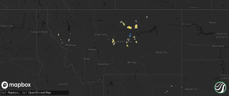
Hail
Wind
291
Estimated number of impacted properties by a 1.00" hail or larger0
Estimated number of impacted properties by a 1.75" hail or larger0
Estimated number of impacted properties by a 2.50" hail or largerStorm reports in Montana
Montana
| Date | Description |
|---|---|
| 05/28/202611:15 PM CDT | Mesonet station mtstm st. Marie mt-24 mp 18.0. |
| 05/28/20269:00 PM CDT | Wagm8 mesonet observation site. |
| 05/28/20268:25 PM CDT | Straight-line winds knocked down multiple tree limbs and caused the power to go out. Nearby automated sensors were gusting 35-40 mph. |
| 05/28/20267:30 PM CDT | A local report indicates 70 MPH wind near 13 ENE Roy |
All States Impacted by Hail Map on May 29, 2026
Cities Impacted by Hail Map on May 29, 2026
- Pueblo, CO
- Avondale, CO
- Colorado Springs, CO
- Peyton, CO
- Lead, SD
- Watonga, OK
- Hitchcock, OK
- Fairview, OK
- Kit Carson, CO
- Superior, MT
- Kingfisher, OK
- Okeene, OK
- Alberton, MT
- Hennessey, OK
- Ames, OK
- Waukomis, OK
- Drummond, OK
- Enid, OK
- Chinook, MT
- Geyser, MT
- Ringwood, OK
- Forest Grove, MT
- Meno, OK
- Stratton, CO
- Lahoma, OK
- Carrier, OK
- Hays, MT
- Isabella, OK
- Grass Range, MT
- Stanford, MT
- Bethune, CO
- Zortman, MT
- Hobson, MT
- Goltry, OK
- Helena, OK
- Kremlin, OK
- Clarendon, TX
- Plains, MT
- Saint Regis, MT
- Nash, OK
- Arlee, MT
- Frenchtown, MT
- Cheyenne Wells, CO
- Quitaque, TX
- Missoula, MT
- Avon Park, FL
- Silverton, TX
- Turkey, TX
- Summerfield, TX
- Hereford, TX
- Lloyd, MT
- Coffee Creek, MT
- Stevensville, MT
- Pond Creek, OK
- Rantoul, KS
- Paola, KS
- Sebring, FL
- Alva, OK
- Burlington, CO
- Hunter, OK
- Roundup, MT
- Lakeview, TX
- Oakley, KS
- Lorida, FL
- Harrisburg, NE
- Moccasin, MT
- Burlington, OK
- Medford, OK
- Memphis, TX
- Idalia, CO
- Albin, WY
- Lagrange, WY
- Dimmitt, TX
- Hawk Springs, WY
- Yoder, WY
- Spearville, KS
- Osawatomie, KS
- Winnett, MT
- Wright, KS
- Cherokee, OK
- Douglas, OK
- Yuma, CO
- Colby, KS
- Canyon, TX
- Happy, TX
- Wakita, OK
- Manchester, OK
- Torrington, WY
- Waldron, KS
- Amorita, OK
- Hazelton, KS
- Ronan, MT
- Tulia, TX
- Kiowa, KS
- Gem, KS
- Anthony, KS
- Medicine Lodge, KS
- Big Sandy, MT
- Peabody, KS
- Florence, KS
- Lingle, WY
- Atwood, KS
- Kinsley, KS
- Lewis, KS
- Mapleton, KS
- Redfield, KS
- Bronson, KS
- Ness City, KS
- Marshall, OK
- Sharon, KS
- Crescent, OK
- Attica, KS
- Clewiston, FL
- South Bay, FL
- Burdett, KS
- Belpre, KS
- Amarillo, TX
- Fort Scott, KS
- Bazine, KS
- Nashville, KS
- Hanston, KS
- Childress, TX
- Harper, KS
- Garfield, KS
- Larned, KS
- Zenda, KS
- Herndon, KS
- Rexford, KS
- Fort Stockton, TX
- Benkelman, NE
- Parks, NE
- Fontana, KS
- Belle Glade, FL
- Marion, KS
- McDonald, KS
- Wayside, TX
- Claude, TX
- Alexander, KS
- Sawyer, KS
- Isabel, KS
- Jay Em, WY
- Spivey, KS
- Kingman, KS
- Cunningham, KS
- Malta, MT
- Roy, MT
- Dix, NE
- McCracken, KS
- La Crosse, KS
- Iraan, TX
- Hays, KS
- Max, NE
- Stratton, NE
- St John, KS
- Levant, KS
- Great Bend, KS
- Macksville, KS
- Schoenchen, KS
- Victoria, KS
- Lelia Lake, TX
- Iuka, KS
- Stafford, KS
- Palisade, NE
- Potter, NE
- Hedley, TX
- Hayes Center, NE
- Ellinwood, KS
- Quail, TX
- Dalton, NE
- Gorham, KS
- Turon, KS
- McCook, NE
- Shamrock, TX
- Wellington, TX
- Selden, KS
- Oberlin, KS
- Chase, KS
- Bushton, KS
- Natoma, KS
- Paradise, KS
- Maywood, NE
- Bridgeport, NE
- Mclean, TX
- Gillette, WY
- Loring, MT
- Bunker Hill, KS
- Lyons, KS
- Russell, KS
- Geneseo, KS
- Danbury, NE
- Lebanon, NE
- Norcatur, KS
- Dorrance, KS
- Shidler, OK
- Wilsonville, NE
- Indianola, NE
- Luray, KS
- Dodson, TX
- Lucas, KS
- Hollis, OK
- Hinsdale, MT
- Cambridge, NE
- Pawhuska, OK
- Sylvan Grove, KS
- Hendley, NE
- Beaver City, NE
- Moorcroft, WY
- Arapahoe, NE
- Edison, NE
- Holbrook, NE
- Hunter, KS
- Gould, OK
- Bartlesville, OK
- Barnard, KS
- Beloit, KS
- Oxford, NE
- Bertrand, NE
- Miltonvale, KS
- Delphos, KS
- Minneapolis, KS
- Copan, OK
- Glasco, KS
- Stamford, NE
- Elwood, NE
- Duke, OK
- Dewey, OK
- Concordia, KS
- Quanah, TX
- Smithfield, NE
- Nowata, OK
- Delaware, OK
- Clay Center, KS
- Eldorado, OK
- Lexington, NE
- Clyde, KS
- Overton, NE
- Clifton, KS
- Leonardville, KS
- Randolph, KS
- Riley, KS
- Linn, KS
- Palmer, KS
- Olsburg, KS
- Saint George, KS
- Westmoreland, KS
- Burns, KS
- Frankfort, KS
- Onaga, KS
- Wamego, KS
- Adair, OK
- Pryor, OK
- Havensville, KS
- Wilson, KS
- Pickrell, NE
- Lewiston, NE
- Soldier, KS
- Lincoln, KS
- Crab Orchard, NE
- Oskaloosa, KS
- Shelby, NE
- Osceola, NE
- Leigh, NE
- Cameron, MO
- Westphalia, KS
- Colony, KS
- Lamont, OK
- Rayville, MO
- Lawson, MO
- Polo, MO
- Kincaid, KS
- Welda, KS
- Fulton, KS
- Uniontown, KS


