Hail Map in Texas on June 2, 2026
The weather event in Texas on June 2, 2026 includes Hail and Wind maps. 15 states and 542 cities were impacted and suffered possible damage. The total estimated number of properties impacted is 76,445.
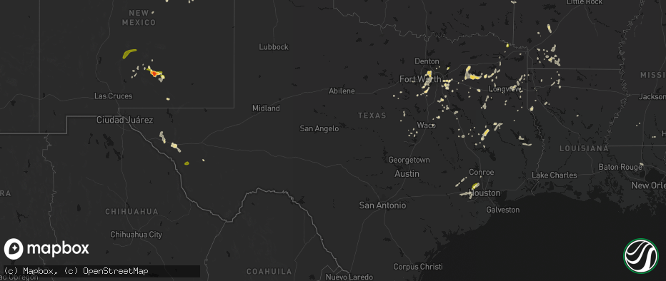
Hail
Wind
76,445
Estimated number of impacted properties by a 1.00" hail or larger2,568
Estimated number of impacted properties by a 1.75" hail or larger0
Estimated number of impacted properties by a 2.50" hail or largerStorm reports in Texas
Texas
| Date | Description |
|---|---|
| 06/02/20266:44 PM CDT | Huge limbs blown down on some back roads. |
| 06/02/20266:23 PM CDT | Egg size hail reported near lebanon rd in the colony. |
| 06/02/20266:15 PM CDT | 10 to 12 inch diameter trees reported down across white settlement rd just west of the parker county line. |
| 06/02/20266:06 PM CDT | A local report indicates 62 MPH wind near 4 WNW Stratford |
| 06/02/20265:42 PM CDT | Facebook photos showed a few trees down across grapevine including on oak grove loop and mustang drive. |
| 06/02/20265:38 PM CDT | Tree across fm2743 and fm3373. |
| 06/02/20265:38 PM CDT | Facebook report of quarter size hail reported along hwy 114 in grapevine. |
| 06/02/20265:31 PM CDT | Good size trees down and power out near cr32 in the ebenezer community. |
| 06/02/20265:29 PM CDT | Facebook report of a tree blown down on peak street. |
| 06/02/20265:25 PM CDT | Intermittent quarter to ping pong ball size hail at us 67 and fm 2738. |
| 06/02/20265:25 PM CDT | Quarter to ping pong ball size hail at us 67 and cr 607 near venus. |
| 06/02/20265:05 PM CDT | Ping pong ball size hail reported on seagoville rd near i 635. |
| 06/02/20265:05 PM CDT | Utility poles and tree limbs down on seagoville rd near i 635 in balch springs. |
| 06/02/20265:00 PM CDT | 911 dispatch reported a few trees down around the town of chireno. Time estimated by radar. |
| 06/02/20264:27 PM CDT | Report from mping: quarter |
| 06/02/20264:27 PM CDT | Report from mping: quarter |
| 06/02/20264:23 PM CDT | Report from mping: quarter |
| 06/02/20264:21 PM CDT | Report from mping: quarter |
| 06/02/20264:17 PM CDT | Broadcast media passed along a report from a caller... Mentioning hail was occurring along cypress north houston road. Hail was estimated at nickel to quarter size. |
| 06/02/20264:15 PM CDT | 911 dispatch reported a few trees down around the community of martinsville. Time estimated by radar. |
| 06/02/20264:12 PM CDT | Spotter report of a few large tree branches down in northeast part of combine. |
| 06/02/20263:50 PM CDT | Facebook report of large tree branches down and nickel size hail on beaver creek rd. Time estimated. |
| 06/02/20263:45 PM CDT | Trees down across harrison county. |
| 06/02/20263:40 PM CDT | A local report indicates 1.00 inch wind near Lavon |
| 06/02/20263:30 PM CDT | Facebook report and photos of several trees down in tennessee colony with one tree completely blocking fm 321. One home had minor roof damage. |
| 06/02/20262:45 PM CDT | Tree on house. |
| 06/02/20262:35 PM CDT | Trees down around lindale. |
| 06/02/20262:30 PM CDT | Trees down in hallsville. |
| 06/02/20262:00 PM CDT | Trees down across harrison county east of marshall. |
| 06/02/20261:48 PM CDT | Large tree blown down at corner of baylor drive and karen drive in tyler. |
| 06/02/20261:45 PM CDT | Corrects previous tstm wnd dmg report from whitehouse. Tree on house. |
| 06/02/20261:29 PM CDT | Local media provided picture of boat dock covering destroyed on lake tyler east. |
| 06/01/202611:35 PM CDT | Mesonet at seminole recorded a thunderstorm wind gust of 61 mph associated with outflow. |
| 06/01/20268:56 PM CDT | Awos station khyi san marcos regional arpt. |
| 06/01/20268:27 PM CDT | Report from mping. Quarter sized hail. |
| 06/01/20268:20 PM CDT | Facebook report of pea to quarter size hail on southwest side of hubbard creek lake. |
| 06/01/20268:15 PM CDT | Location and time approx based on radar. Social media post showed hail stones near 1 inch. |
| 06/01/20267:46 PM CDT | Broadcast media relayed a report and photo of several powerlines down on watson lane west between interstate 35 and farm to market road 1102. Time estimated by radar. |
All States Impacted by Hail Map on June 2, 2026
Cities Impacted by Hail Map on June 2, 2026
- Bunch, OK
- Rolla, KS
- Chester, AR
- Natural Dam, AR
- Pocola, OK
- Fort Smith, AR
- Stilwell, OK
- Mountainburg, AR
- Goodwell, OK
- Booneville, AR
- Mansfield, AR
- Waldron, AR
- Heavener, OK
- Poteau, OK
- Mena, AR
- Shady Point, OK
- Sanborn, ND
- Rogers, ND
- Howe, OK
- Guymon, OK
- Hooker, OK
- Cooperstown, ND
- Aneta, ND
- Edmore, ND
- Conchas Dam, NM
- Milton, ND
- Osnabrock, ND
- Fairdale, ND
- Mescalero, NM
- Santa Rosa, NM
- McGregor, TX
- Richwood, WV
- Langdon, ND
- De Kalb, TX
- Cavalier, ND
- Walhalla, ND
- Mountain, ND
- Magnolia, AR
- Mosquero, NM
- Willow City, ND
- Oglesby, TX
- Mineral Springs, AR
- Moody, TX
- McCaskill, AR
- Emerson, AR
- Newkirk, NM
- Rolette, ND
- Hebron, NE
- Dunseith, ND
- Carleton, NE
- Athens, TX
- Okolona, AR
- Blevins, AR
- Reva, SD
- Tyler, TX
- Homer, LA
- Gatesville, TX
- Neche, ND
- Belcourt, ND
- Texarkana, TX
- Rugby, ND
- De Berry, TX
- Fort Hood, TX
- Waldo, AR
- Saint John, ND
- Belle Fourche, SD
- Whitehouse, TX
- Souris, ND
- Garita, NM
- Athens, LA
- Hope, AR
- Fairmont, NE
- Marshall, TX
- Minden, LA
- Haynesville, LA
- Troup, TX
- Overton, TX
- Hallsville, TX
- Newell, SD
- Rolla, ND
- Bottineau, ND
- Garland City, AR
- Gibsland, LA
- Lindale, TX
- Cookville, TX
- Mount Pleasant, TX
- Buffalo, SD
- Grafton, NE
- Jonesboro, TX
- Taylor, AR
- Nara Visa, NM
- Omaha, TX
- Pittsburg, TX
- Rosston, AR
- Jacksonville, TX
- Mayhill, NM
- Arcadia, LA
- West Palm Beach, FL
- Stamps, AR
- Benton, LA
- Max, ND
- Sibley, LA
- Bullard, TX
- Lewisville, AR
- Garrison, ND
- Buckner, AR
- Mount Calm, TX
- Hubbard, TX
- Coolidge, TX
- Canton, TX
- Vaughn, NM
- Mart, TX
- Riesel, TX
- Waco, TX
- Perth, ND
- Cloudcroft, NM
- Ben Wheeler, TX
- La Luz, NM
- Cranfills Gap, TX
- Meridian, TX
- Minot, ND
- Oelrichs, SD
- Rocklake, ND
- Hansboro, ND
- Bisbee, ND
- Sawyer, ND
- Mcclusky, ND
- Stephens, AR
- Kadoka, SD
- Pine Ridge, SD
- Jefferson, TX
- Henderson, TX
- Shreveport, LA
- Kemp, TX
- Winnsboro, TX
- Como, TX
- Quitman, TX
- Axtell, TX
- Gilmer, TX
- Norwich, ND
- Fort Davis, TX
- Interior, SD
- Butte, ND
- Vivian, LA
- Oglala, SD
- Surrey, ND
- Iredell, TX
- Scurry, TX
- Bent, NM
- Point, TX
- Lone Oak, TX
- Hannah, ND
- McNeil, AR
- Kyle, SD
- Kaufman, TX
- Wills Point, TX
- Joaquin, TX
- Tenaha, TX
- Gloster, LA
- Mercer, ND
- Drake, ND
- Philip, SD
- Karnack, TX
- Mineola, TX
- Nevada, TX
- Conroe, TX
- Ennis, TX
- Tularosa, NM
- Emory, TX
- Palm Beach Gardens, FL
- Big Sandy, TX
- Deering, ND
- Timpson, TX
- Sarles, ND
- Lavon, TX
- Alba, TX
- Cumby, TX
- Logansport, LA
- Grand Cane, LA
- Houston, TX
- Coushatta, LA
- Gladewater, TX
- Stephenville, TX
- Edgewood, TX
- Granville, ND
- Kiln, MS
- Dawson, TX
- Weed, NM
- Egeland, ND
- Corsicana, TX
- Fairfield, TX
- Streetman, TX
- Rosser, TX
- Cleburne, TX
- Spring, TX
- Calvin, ND
- Adrian, TX
- Bluff Dale, TX
- Daytona Beach, FL
- Anamoose, ND
- Wanblee, SD
- Mansfield, LA
- Barry, TX
- Leakesville, MS
- Neely, MS
- Devils Lake, ND
- Manderson, SD
- State Line, MS
- Fruitdale, AL
- Center, TX
- Pass Christian, MS
- Saucier, MS
- Gulfport, MS
- Alamogordo, NM
- Munich, ND
- Channing, TX
- Crandall, TX
- Seagoville, TX
- Tylertown, MS
- Van Horn, TX
- Holloman Air Force Base, NM
- Alto, TX
- Webster, ND
- Port Orange, FL
- Ferris, TX
- Porcupine, SD
- Cypress, TX
- Nacogdoches, TX
- Terrell, TX
- Forney, TX
- Lance Creek, WY
- Flagler Beach, FL
- Palm Coast, FL
- Purdon, TX
- Tolar, TX
- Douglass, TX
- Waller, TX
- Hockley, TX
- Saint Stephens, AL
- Leroy, AL
- New Smyrna Beach, FL
- Italy, TX
- Kilgore, TX
- Prairie View, TX
- Hempstead, TX
- Starkweather, ND
- Katy, TX
- Tolna, ND
- Warwick, ND
- Zolfo Springs, FL
- Ormond Beach, FL
- Brookhaven, MS
- Pinon, NM
- Miami, FL
- Kennard, TX
- Crockett, TX
- Irving, TX
- Grapeland, TX
- Sierra Blanca, TX
- Edgewater, FL
- Blooming Grove, TX
- Hope, NM
- Maddock, ND
- Allen, SD
- Hartley, TX
- Dalhart, TX
- Midlothian, TX
- Oak Hill, FL
- Osteen, FL
- Mesquite, TX
- Dallas, TX
- Buffalo, TX
- Crary, ND
- San Jon, NM
- Bard, NM
- Mansfield, TX
- Arlington, TX
- Bellville, TX
- Venus, TX
- Centerville, TX
- Grand Prairie, TX
- Lakota, ND
- Wells, TX
- Hammond, LA
- Valentine, TX
- Lawton, ND
- Buffalo Gap, SD
- Chacon, NM
- Mora, NM
- Esmond, ND
- Lovelady, TX
- Burleson, TX
- Pollok, TX
- Georgetown, LA
- Alvarado, TX
- Alsen, ND
- Douglas, WY
- Jasper, TX
- Richmond, TX
- Logan, NM
- Fulshear, TX
- Brookshire, TX
- Coppell, TX
- Hoven, SD
- Java, SD
- Harvey, ND
- Grapevine, TX
- Euless, TX
- White River, SD
- Selby, SD
- Broaddus, TX
- Lorida, FL
- Brocket, ND
- Bedford, TX
- Wales, ND
- Truth Or Consequences, NM
- Carrizozo, NM
- Grandview, TX
- Jewett, TX
- Plano, TX
- Fort Sumner, NM
- Fort Worth, TX
- Steele, ND
- Trinity, TX
- Hurst, TX
- Colleyville, TX
- Rosenberg, TX
- Fairburn, SD
- Oakwood, TX
- Marquez, TX
- Okeechobee, FL
- Hurdsfield, ND
- Chaseley, ND
- Sealy, TX
- Wallis, TX
- Cimarron, NM
- Chamisal, NM
- Bowdle, SD
- Normangee, TX
- Carrollton, TX
- Robinson, ND
- Dawson, ND
- Aledo, TX
- Adams, ND
- Hot Springs, SD
- Edgemont, SD
- Linton, ND
- Oral, SD
- Martin, SD
- Kintyre, ND
- Haltom City, TX
- Hampden, ND
- Hensel, ND
- Caldwell, TX
- Leesville, LA
- Cuervo, NM
- Frisco, TX
- Weatherford, TX
- The Colony, TX
- Eureka, SD
- Tappen, ND
- Dime Box, TX
- Napoleon, ND
- Balch Springs, TX
- Herreid, SD
- Upton, WY
- Godley, TX
- Cresson, TX
- Gause, TX
- Pettibone, ND
- Leander, TX
- Sundance, WY
- McLaughlin, SD
- Lexington, TX
- Tuthill, SD
- Schulenburg, TX
- Azle, TX
- Moorcroft, WY
- Selfridge, ND
- Murdo, SD
- Granbury, TX
- Dell City, TX
- Custer, SD
- Clewiston, FL
- Weimar, TX
- Lipan, TX
- Moore Haven, FL
- Draper, SD
- Rockdale, TX
- Cameron, TX
- Bathgate, ND
- Woodworth, ND
- Lehr, ND
- Milano, TX
- Gackle, ND
- Paige, TX
- Devils Tower, WY
- Hamilton, ND
- Fredonia, ND
- Hearne, TX
- Wood, SD
- Streeter, ND
- Seminary, MS
- Alva, WY
- Hammond, MT
- Lead, SD
- Hulett, WY
- Austin, TX
- Gillette, WY
- Mission, SD
- Vivian, SD
- Thrall, TX
- Thorndale, TX
- Del Valle, TX
- Presho, SD
- Okreek, SD
- Ekalaka, MT
- Michigan, ND
- Spearfish, SD
- Chadron, NE
- Cleveland, ND
- Medina, ND
- Edinburg, ND
- Harwood, TX
- Luling, TX
- Breckenridge, TX
- Coleman, TX
- Santa Anna, TX
- Brady, TX
- Buchanan, ND
- El Paso, TX
- Buda, TX
- Montpelier, ND
- Johnson City, TX
- Lankin, ND
- Kensal, ND
- Courtenay, ND
- Kyle, TX
- Hoople, ND
- Gonzales, TX
- Pingree, ND
- Park River, ND
- Glenfield, ND
- Voca, TX
- Jamestown, ND
- Alzada, MT
- Boyes, MT
- Nixon, TX
- Fort Bliss, TX
- Wimberley, TX
- Tuttle, ND
- Blanco, TX
- Dripping Springs, TX
- Hannaford, ND
- Sutton, ND
- Binford, ND
- Spiritwood, ND
- Fordville, ND
- Mason, TX
- Tahlequah, OK
- Seguin, TX
- Petersburg, ND
- Broken Arrow, OK
- Tulsa, OK
- Wimbledon, ND
- San Marcos, TX
- Baker, MT
- Martindale, TX
- Maxwell, TX
- Melrose, NM
- Mcville, ND
- Wounded Knee, SD
- Dazey, ND
- Roswell, NM
- Smiley, TX
- Hay Springs, NE
- Stockdale, TX
- Whitney, NE
- Dahlen, ND
- Finley, ND
- Jessie, ND
- Sharon, ND
- Niagara, ND
- Gillett, TX
- Rushville, NE
- Menard, TX
- Hext, TX
- Saint Francis, SD
- Batesland, SD
- Roscoe, TX
- Rhame, ND
- Fort Pierre, SD
- Maryneal, TX
- Norris, SD
- Mandan, ND
- Harrold, SD
- Amidon, ND
- Bowman, ND
- Lower Brule, SD
- Bismarck, ND
- Kennebec, SD
- Pierre, SD
- Post, TX
- Reliance, SD
- Snyder, TX
- Hermleigh, TX
- Highmore, SD
- Holabird, SD
- Ira, TX
- Tahoka, TX
- Parmelee, SD
- Wilson, TX
- Muskogee, OK
- Fluvanna, TX
- Hermosa, SD
- Gordon, NE
- Gail, TX
- Clovis, NM
- Larimore, ND
- Merriman, NE
- Odonnell, TX
- Cody, NE
- Nenzel, NE
- Kilgore, NE
- Ackerly, TX
- Fessenden, ND
- Kress, TX
- Wood Lake, NE
- Springview, NE
- Silverton, TX
- Howes, SD
- Hialeah, FL
- Dexter, NM
- Hagerman, NM
- Artesia, NM
- Lake Arthur, NM
- Loving, NM
- Carlsbad, NM
- Taiban, NM
- Stratford, TX
- Zeeland, ND
- Ashley, ND


