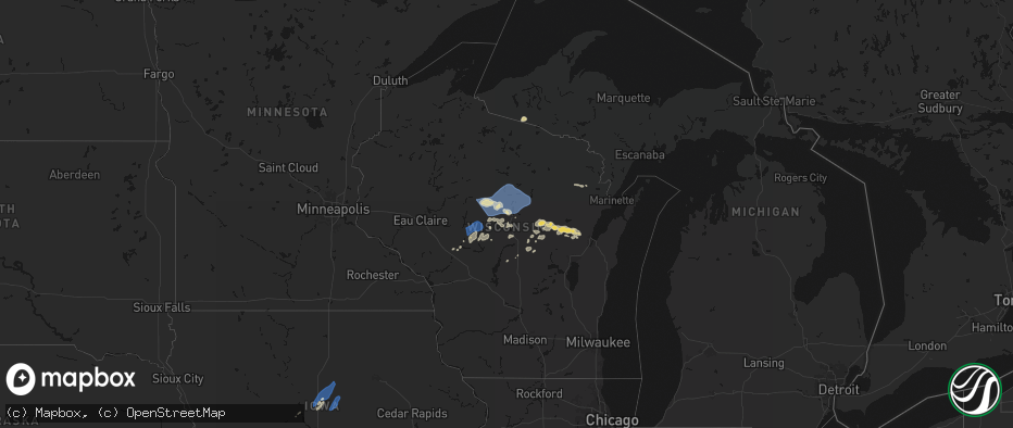
Hail Map on June 10, 2026
The weather event on June 10, 2026 includes Wind, Hail, and Tornado maps. 18 states and 2,073 cities were impacted and suffered possible damage. The total estimated number of properties impacted is 310,367.
Wind
Hail
Tornado
310,367
Estimated number of impacted properties by a 1.00" hail or larger27,530
Estimated number of impacted properties by a 1.75" hail or larger5,896
Estimated number of impacted properties by a 2.50" hail or largerStates Impacted by Hail Map on June 10, 2026
Storm reports
Indiana
| Date | Description |
|---|---|
| 06/10/20266:55 PM CDT | Several trees down reported in south kokomo. Time estimated from radar. |
| 06/10/20266:15 PM CDT | Warsaw municipal airport. |
| 06/10/20266:15 PM CDT | Goshen municipal airport. |
| 06/10/20266:00 PM CDT | Powerlines down. |
| 06/10/20266:00 PM CDT | Powerlines downed. |
| 06/10/20265:54 PM CDT | A local report indicates 1.00 inch wind near 2 SW Lafayette |
| 06/10/20265:40 PM CDT | Several trees downed in the plymouth area. |
| 06/10/20265:20 PM CDT | A local report indicates 60 MPH wind near Kingsford Heights |
| 06/10/20265:18 PM CDT | Starke county airport. |
| 06/10/20265:12 PM CDT | Peak gust measured on personal weather station. |
| 06/10/20265:10 PM CDT | Peak gust measured on personal weather station. |
| 06/10/20264:25 PM CDT | Video shared to social media shows large tree snapped in griffith. Time estimated by radar. |
| 06/10/20264:16 PM CDT | Multiple trees downed in whiting. |
| 06/10/20264:15 PM CDT | Peak gust measured on personal weather station. |
| 06/10/20264:10 PM CDT | Minor shingle damage also reported. |
| 06/10/20262:44 AM CDT | Debris in area from shingles off roofs... Fences down... And reportedly a/c unit knocked off its block. Time estimated from radar. |
Iowa
| Date | Description |
|---|---|
| 06/10/20266:47 PM CDT | Tree damage with power lines down. Time estimated via radar. |
| 06/10/20266:32 PM CDT | Estimated wind gust from spotter network. |
| 06/10/20266:18 PM CDT | Measured by anemometer. |
| 06/10/20266:17 PM CDT | Peak wind gust at the davenport municipal airport. |
| 06/10/20266:17 PM CDT | Several 12 to 15 inch limbs down along with trees 1 to 2 feet in diameter. Estimating 80 mph winds. |
| 06/10/20266:14 PM CDT | Estimate of 70 mph with. |
| 06/10/20265:51 PM CDT | Section of a sheet metal roof was ripped off. Picture sent via social media. Time estimated by radar. |
| 06/10/20265:25 PM CDT | Brief touchdown. |
| 06/10/20265:24 PM CDT | Report from trained spotter. |
| 06/10/20265:11 PM CDT | Confirmed tornado via broadcast media. |
| 06/10/20265:07 PM CDT | A local report indicates 60 MPH wind near 4 SE Kirkville |
| 06/10/20264:30 PM CDT | Delayed report - time estimated from radar. Received email from media relaying 2 hail in weldon. |
| 06/10/20264:12 PM CDT | Building damage per ema. |
| 06/10/20263:54 PM CDT | Local fire chief reports several intermittent touchdowns. |
| 06/10/20262:15 PM CDT | A local report indicates 58 MPH wind near 1 SSE Stanwood |
| 06/10/20261:11 PM CDT | Widespread large trees down. |
| 06/10/20261:04 PM CDT | Spotter estimated winds of 50 to 60 mph with thunderstorm. |
| 06/10/202612:54 PM CDT | Large spruce tree down. |
| 06/10/202612:54 PM CDT | Large tree snapped off near the base. Trunk diameter over a foot. |
| 06/10/202612:50 PM CDT | Branch snapped 6 inch diameter. |
| 06/10/202612:49 PM CDT | Tree branches over a foot in diameter downed. Estimated wind gust of 65 mph by car anemometer. |
| 06/10/202612:45 PM CDT | 6 inch tree limbs snapped. Time estimated by radar. |
| 06/10/202612:45 PM CDT | Couple trees uprooted along with many branches downed and some fence damage... Including along asbury road near bunker hill golf course. Time estimated using radar. |
| 06/10/202612:42 PM CDT | Tree down 1 mile west of epworth reported by off duty nws employee. |
| 06/10/202612:42 PM CDT | Many small to medium sized branches blown down. A larger size branch causing traffic issues on one downtown street. Medium sized tree uprooted in front yard 3 houses fr |
| 06/10/202612:40 PM CDT | Em reports widespread 70-80 mph winds in the area with numerous trees down and power outages. Some traffic lights have power out on hwy 20. |
| 06/10/202612:40 PM CDT | Peak wind gust at dubuque regional airport. |
| 06/10/202612:40 PM CDT | Several trees blown down east of peosta. Reported by off duty nws employee. The time of the event was estimated using radar. |
| 06/10/202612:33 PM CDT | A local report indicates 65 MPH wind near 3 ENE Monticello Munici |
| 06/10/202612:30 PM CDT | Tree down near the intersection of county rd 64 and 200th ave. Time estimated by radar. |
| 06/10/202612:20 PM CDT | Powerlines leaning. |
| 06/10/202612:15 PM CDT | A local report indicates 66 MPH wind near 1 NW Park View |
| 06/10/202612:15 PM CDT | Corrects previous tstm wnd gst report from 1 sse stanwood. |
| 06/10/202612:15 PM CDT | 10 inch tree limbs reported down in eden valley refuge. Time estimated by radar. |
| 06/10/202612:14 PM CDT | 2 inch tree limb down. The time of the event was estimated using radar. |
| 06/10/202612:07 PM CDT | Power lines down over road near intersection of 215th st and nathan bethel ave. Time estimated by radar. |
| 06/10/202611:49 AM CDT | Delayed report. Peak wind gust from a personal weather station. |
| 06/10/202611:44 AM CDT | Delayed report. Peak wind gust from a personal weather station. |
| 06/10/202611:35 AM CDT | Tree with 4 to 6 inch diameter trunk snapped at the base. |
| 06/10/202611:30 AM CDT | Wind gust measured by house anemometer and 1 inch tree limbs down. Time estimated by radar. |
| 06/10/202611:25 AM CDT | Large tree split in half... Taking down powerlines. |
| 06/10/202611:25 AM CDT | Large tree toppled one and a quarter mile south of frytown. |
| 06/10/202611:25 AM CDT | Large tree toppled at my sisters place one and a quarter mile south of frytown. |
| 06/10/202611:19 AM CDT | A local report indicates 62 MPH wind near 2 SW Williamstown |
| 06/10/202611:01 AM CDT | Tree limbs over a foot in diameter were snapped. Picture sent via social media. Time estimated by radar. |
| 06/10/202611:01 AM CDT | Delayed report. Peak wind gust from a personal weather station. |
| 06/10/202611:00 AM CDT | Delayed report. Peak wind gust from a personal weather station. |
| 06/10/202611:00 AM CDT | Large tree down in hubbard. Time estimated by radar. |
| 06/10/202610:57 AM CDT | Delayed report... Peak wind gust from the kmiw marshalltown airport asos. |
| 06/10/202610:50 AM CDT | Delayed report. Peak wind gust from a personal weather station. |
| 06/10/202610:46 AM CDT | Delayed report. Peak wind gust from personal weather station. |
| 06/10/20266:55 AM CDT | Delayed entry - measured from kcsq. |
| 06/10/20266:55 AM CDT | A local report indicates 1.00 inch wind near Afton |
| 06/10/20266:55 AM CDT | Relayed via nws chat. |
| 06/10/20266:55 AM CDT | Delayed report - time estimated from radar. Photo from social media with tree branches down across roadway. |
| 06/10/20266:53 AM CDT | Measured from personal weather station. |
| 06/10/20266:50 AM CDT | Delayed report - time estimated from radar. Received report via email of damage to several grain bins. |
| 06/10/20266:50 AM CDT | Delayed report - time estimated from radar. Photo received via social media. |
| 06/10/20266:50 AM CDT | Delayed report - time estimated by radar. Received photos of damage via email. |
| 06/10/20266:47 AM CDT | Measured from personal weather station. |
| 06/10/20266:45 AM CDT | Delayed report - time estimated from radar. Damage to machine shed on social media. |
| 06/10/20266:45 AM CDT | A local report indicates 1.00 inch wind near Creston |
| 06/10/20266:38 AM CDT | Measured from personal weather station. |
| 06/10/20266:34 AM CDT | Report from mping: quarter |
| 06/10/20266:31 AM CDT | A local report indicates 65 MPH wind near Shambaugh |
| 06/10/20266:30 AM CDT | Delayed report - time estimated by radar. Received photo from trained spotter of tree limb down. |
| 06/10/20266:30 AM CDT | Received photo of several tree limbs down. Time estimated from radar. |
| 06/10/20266:30 AM CDT | Damage reported in corning... Will further assess source of damage. |
| 06/10/20266:24 AM CDT | Nws cooperative weather observer reports thunderstorm winds lifted the stainless steel rain gage out of its holder and tossed it around 30 ft away. Time estimated from |
| 06/10/20266:24 AM CDT | Delayed report. |
| 06/10/20266:20 AM CDT | Tree down on building. Time estimated by radar. |
| 06/10/20266:18 AM CDT | Measured from personal weather station. |
| 06/10/20266:15 AM CDT | Delayed report of damaged grain bins blown near the interchange of us-34 and us-71... North of villisca. Time estimated with radar. |
| 06/10/20266:15 AM CDT | Several reports of trees and power poles down across atlantic found on social media. Time estimated from radar. |
| 06/10/20266:14 AM CDT | A local report indicates 73 MPH wind near 0.5 WNW Villisca |
| 06/10/20266:13 AM CDT | A local report indicates 58 MPH wind near 4.5 W Hepburn |
| 06/10/20266:12 AM CDT | A local report indicates 66 MPH wind near 3.8 SE Stanton |
| 06/10/20266:12 AM CDT | Emergency management report of several trees and large branches down along the page/montgomery county line. Power lines across roads. The majority of n/s roads are bloc |
| 06/10/20266:07 AM CDT | 60 mph wind estimated. Quarter sized hail and large limbs down. |
| 06/10/20266:06 AM CDT | A local report indicates 59 MPH wind near 9.0 ESE Oakland |
| 06/10/20266:01 AM CDT | A local report indicates 71 MPH wind near 4.9 SSE Coburg |
| 06/10/20265:58 AM CDT | Small tree and debris in coburg. |
| 06/10/20265:56 AM CDT | Trees blocking hwy 48 south of essex. |
| 06/10/20265:55 AM CDT | A local report indicates 63 MPH wind near 3.0 NNW Coburg |
| 06/10/20265:55 AM CDT | A local report indicates 90 MPH wind near Essex |
| 06/10/20265:47 AM CDT | A local report indicates 71 MPH wind near 6.1 N Glenwood |
| 06/10/20265:47 AM CDT | A local report indicates 80 MPH wind near 2.1 SSE Silver City |
| 06/10/20265:47 AM CDT | A local report indicates 67 MPH wind near 2.6 NW Silver City |
| 06/10/20265:46 AM CDT | A local report indicates 58 MPH wind near 3.5 N Silver City |
| 06/10/20265:45 AM CDT | Report of damage to a self-serve gas station... With one third of the roof a metal building removed by straight line winds. Time estimated from radar. |
| 06/10/20265:45 AM CDT | Delayed report received via social media of several large tree branches down in malvern... Iowa. Time estimated with radar. |
| 06/10/20265:42 AM CDT | A local report indicates 73 MPH wind near 4.2 NNE Tabor |
| 06/10/20265:40 AM CDT | A local report indicates 63 MPH wind near Glenwood |
| 06/10/20265:35 AM CDT | Delayed report of several tree branches down |
| 06/10/20265:30 AM CDT | A local report indicates 2.50 inch wind near Yorktown |
| 06/10/20265:30 AM CDT | Delayed emergency management report of a measured hailstone 3.5 inches in diameter... Shown in a photo next to a ruler. Time estimated with radar. |
| 06/10/20265:19 AM CDT | Delayed report received via social media of hail measured up to 3 inches in diameter with corresponding picture. Time estimated with radar. |
| 06/10/20265:07 AM CDT | Delayed report received via social media of hail estimated up to 2 inches in diameter. Time estimated with radar. |
| 06/09/20268:30 PM CDT | Small branches down via social media. |
| 06/09/20267:41 PM CDT | Multiple trees and power lines down. Time estimated via radar. |
| 06/09/20267:32 PM CDT | Mping report. |
| 06/09/20267:17 PM CDT | Image via social media. Time estimated from radar. |
| 06/09/20267:06 PM CDT | Received photo via social media of fallen tree on fence in altoona. |
Texas
| Date | Description |
|---|---|
| 06/10/20265:36 PM CDT | Mesonet station 167 toyahvale 13w recorded a wind gust of 64 mph. |
| 06/10/20264:30 PM CDT | Pecos fire dept reported that a semi was overturned and another jackknifed on interstate 20 near mile marker 33. Time estimated from radar. |
Illinois
| Date | Description |
|---|---|
| 06/10/20266:50 PM CDT | 4 to 8 inch diameter tree limb blown down. Time of the event estimated using radar. |
| 06/10/20266:49 PM CDT | Measured by roof mounted anemometer. |
| 06/10/20266:40 PM CDT | Multiple powerlines down off of east wolf road. Tornado possible. Time estimated by radar. |
| 06/10/20266:09 PM CDT | Size estimated from picture. |
| 06/10/20265:04 PM CDT | Delayed report - county em submitted a report from yesterdays severe thunderstorm that impacted the northwest portion of the county just southeast of raymond il. |
| 06/10/20265:03 PM CDT | Corrects previous hail report from 2 ese harvel. Size estimated from picture. |
| 06/10/20265:03 PM CDT | 8-12in diameter tree limbs snapped. |
| 06/10/20264:13 PM CDT | Tree limbs downed. 56 mph gust measured at this location as well. |
| 06/10/20264:10 PM CDT | Numerous large tree branches downed onto cullerton street... Damaging several cars. Power lines were also downed. |
| 06/10/20264:10 PM CDT | Large tree downed onto montrose avenue. Time estimated from radar. |
| 06/10/20264:09 PM CDT | Peak gust measured on personal weather station. |
| 06/10/20264:09 PM CDT | Peak gust measured on personal weather station. |
| 06/10/20264:09 PM CDT | Photos shared to social media show multiple large branches broken near cornelia avenue and southport avenue in the lakeview community area of chicago. Time estimated by |
| 06/10/20264:09 PM CDT | Peak gust measured on personal weather station. |
| 06/10/20264:09 PM CDT | Peak gust measured on personal weather station. |
| 06/10/20264:07 PM CDT | Multiple public reports of tree branches broken in south shore community area of chicago. Relayed by chicago 311. Time estimated by radar. |
| 06/10/20264:07 PM CDT | Peak gust measured on personal weather station. |
| 06/10/20264:06 PM CDT | Photos and videos shared to social media show multiple large branches broken in the lake view community area of chicago. Time estimated by radar. |
| 06/10/20264:06 PM CDT | Photo shared to social media shows a few branches broken near illinois masonic hospital in chicago. Time estimated by radar. |
| 06/10/20264:06 PM CDT | Peak gust measured on private weather station. Time estimated from radar. |
| 06/10/20264:06 PM CDT | Peak gust measured on personal weather station. |
| 06/10/20264:05 PM CDT | Photo shared on social media depicts a roughly 50 foot softwood tree snapped a few feed up from the ground. Time estimated by radar. |
| 06/10/20264:05 PM CDT | Photo shared to social media shows large tree branch downed near hubbard street and aberdeen street in west town community area of chicago. Time estimated by radar. |
| 06/10/20264:05 PM CDT | Reports of estimated 18 inch diameter trees down. |
| 06/10/20264:05 PM CDT | Multiple public reports of tree branches broken in lincoln square... Uptown... And edgewater community areas of chicago. Relayed by chicago 311. Time estimated by radar |
| 06/10/20264:04 PM CDT | Tree downed onto a power line in clinton. Relayed by em. |
| 06/10/20264:04 PM CDT | Windows blown out of a high rise. |
| 06/10/20264:03 PM CDT | Multiple public reports of tree branches broken in auburn gresham community area of chicago. Relayed by chicago 311. Time estimated by radar. |
| 06/10/20264:02 PM CDT | Photos shared to social media show multiple large branches broken near 23rd street and rockwell street in the south lawndale community area of chicago. One tree snapped |
| 06/10/20264:01 PM CDT | Photos shared on social media show extensive tree damage on the south end of lincoln park including uprooted oak trees. |
| 06/10/20264:01 PM CDT | Multiple public reports of tree branches broken in morgan park community area of chicago. Relayed by chicago 311. Time estimated by radar. |
| 06/10/20264:01 PM CDT | Multiple public reports of tree branches broken in washington heights community area of chicago. Relayed by chicago 311. Time estimated by radar. |
| 06/10/20264:00 PM CDT | Video shared on social media shows 2 foot diameter tree uprooted with entire root ball destroying nearby pavement. The tree fell on and destroyed a garage. Time estimat |
| 06/10/20264:00 PM CDT | Pine tree downed. |
| 06/10/20264:00 PM CDT | Personal weather station measured strong wind gusts. Time estimated by radar. |
| 06/10/20264:00 PM CDT | Tree uprooted... Numerous branches around one inch diameter broken in the neighborhood. Siding removed from a nearby house. Time estimated by radar. |
| 06/10/20263:58 PM CDT | Large tree down in the 4400 block of s knox. |
| 06/10/20263:58 PM CDT | Multiple reports of tree branches downed in oak park... Including a large tree uprooted near 96th street and 50th that landed on a car. Time estimated by radar. |
| 06/10/20263:58 PM CDT | 5 inch tree limbs down near foster and newcastle. Time estimated by radar. |
| 06/10/20263:58 PM CDT | Asos station kmdw chicago midway. |
| 06/10/20263:58 PM CDT | Photos shared to social media show numerous large branches broken near vittum park in garfield ridge community area of chicago. Time estimated by radar. |
| 06/10/20263:57 PM CDT | 8 to 10 inch diameter branch downed onto road. Time estimated from radar. |
| 06/10/20263:57 PM CDT | Tree and power lines downed. Time estimated from radar. |
| 06/10/20263:57 PM CDT | Roofing material peeled from an apartment building near pershing road and ridgeland avenue in stickney. Time estimated by radar. |
| 06/10/20263:56 PM CDT | Photo via social media shows a few shingles removed measured from apartment buildings. Time estimated by radar. |
| 06/10/20263:56 PM CDT | 3 foot diameter tree limb snapped off of tree and flag pole bent. Time estimated from radar. |
| 06/10/20263:56 PM CDT | Corrects previous tstm wnd dmg report from 1 sse oak forest. Power lines downed near 167th street and cicero avenue. Time estimated from radar. |
| 06/10/20263:56 PM CDT | Power lines downed near 151st street and laramie avenue. Time estimated from radar. |
| 06/10/20263:55 PM CDT | Social media pictures of assorted branches down... Specifically between 99th to 102nd street and 52nd to 54th avenues. Time estimated by radar. |
| 06/10/20263:55 PM CDT | Several large trees and power lines down. Notably... A 30 inch diameter hickory tree. Time estimated by radar. |
| 06/10/20263:55 PM CDT | Local broadcast media reports that the roof of five story apartment building was torn off. Time estimated by radar. |
| 06/10/20263:55 PM CDT | Road closures due to tree damage in the brookfield area. Time estimated from radar. |
| 06/10/20263:55 PM CDT | Photo shared to social media shows large tree uprooted or snapped near 99th street and cicero avenue. Time estimated by radar. |
| 06/10/20263:54 PM CDT | 5 inch diameter tree broken about a foot above the base. Time estimated from radar. |
| 06/10/20263:53 PM CDT | Multiple branches broken in the brookfield area. Time estimated by radar. |
| 06/10/20263:52 PM CDT | Large diameter tree damage in palos park... Specifically in an area from 123rd to the north. Time approximated by radar. |
| 06/10/20263:52 PM CDT | Photos emailed of snapped trees during the afternoon wind surge. Time estimated by radar. |
| 06/10/20263:52 PM CDT | Multiple reports of trees and power lines downed in wheeling. Time estimated from radar. |
| 06/10/20263:51 PM CDT | Photo via social media shows uprooted evergreen tree. Time estimated by radar. |
| 06/10/20263:49 PM CDT | Multiple reports of trees and power lines downed in mount prospect. Time estimated from radar. |
| 06/10/20263:48 PM CDT | Multiple reports of trees and power lines downed in arlington heights. Time estimated from radar. |
| 06/10/20263:47 PM CDT | Multiple reports of trees and power lines downed in palatine. Time estimated from radar. |
| 06/10/20263:47 PM CDT | 14 inch diameter tree downed. |
| 06/10/20263:45 PM CDT | Multiple public reports of downed trees and large tree limbs across homer glen. |
| 06/10/20263:45 PM CDT | Peak gust measured on personal weather station. |
| 06/10/20263:45 PM CDT | Corrects previous tstm wnd dmg report from 1 nne homer glen. Personal weather station measured 65 mph wind gust. Time estimated by radar. |
| 06/10/20263:45 PM CDT | Personal weather station measured 65 mph wind gust. Time estimted by radar. |
| 06/10/20263:45 PM CDT | Tree branches reported down. Time estimated by radar. |
| 06/10/20263:44 PM CDT | Multiple reports of trees and power lines downed in buffalo grove. Time estimated from radar. |
| 06/10/20263:42 PM CDT | Weber road closed between boughton road and washington street due to downed power lines. Relayed by village of bolingbrook social media. Time estimated by radar. |
| 06/10/20263:42 PM CDT | Numerous reports of tree damage across various parts of naperville. |
| 06/10/20263:42 PM CDT | Large tree branch down on a car. Time estimated by radar. |
| 06/10/20263:42 PM CDT | Large tree limbs downed. Patio furniture also blown around. Time estimated from radar. |
| 06/10/20263:42 PM CDT | 20 year old tree blocking the intersection. Time estimated by radar. |
| 06/10/20263:42 PM CDT | Tree downed onto road in waukegan. Time estimated from radar. |
| 06/10/20263:40 PM CDT | Reports of power lines down and four inch diameter tree branches down. Time estimated by radar. |
| 06/10/20263:40 PM CDT | Scattered branches 1 to 2 inch diameter branches broken near and just north of lewis university. Time estimated by radar. |
| 06/10/20263:40 PM CDT | Updates previous tstm wnd dmg report from diamond. Photos shared showing large branches snapped off of trees in diamond. Fascia was also peeled off of a house... And fe |
| 06/10/20263:40 PM CDT | Photo via social media of a large branch snapped off a tree. Time estimated by radar. |
| 06/10/20263:40 PM CDT | Widely scattered branches up to 3 inches in diameter broken in north romeoville along il-53. Time estimated by radar. |
| 06/10/20263:40 PM CDT | Photo shared to social media shows interstate road sign blown down along i-55 just west of veterans parkway. Time estimated by radar. |
| 06/10/20263:39 PM CDT | Wires downed in multiple locations across elk grove village. Time estimated from radar. |
| 06/10/20263:39 PM CDT | Peak wind gust reported at klot. |
| 06/10/20263:39 PM CDT | Photos shared to social media show branches broken in wood dale. Time estimated by radar. |
| 06/10/20263:39 PM CDT | Tree downed onto power lines. Time estimated from radar. |
| 06/10/20263:38 PM CDT | Forest preserve district of dupage county reports multiple tree branches broken in mcdowell grove forest preserve near naperville. Time estimated by radar. |
| 06/10/20263:38 PM CDT | Tree downed onto power lines. Time estimated from radar. |
| 06/10/20263:37 PM CDT | Large tree branch down on six points rd. Just west of juniper ln. |
| 06/10/20263:37 PM CDT | Photo via social media shows large branch broken. Time estimated by radar. |
| 06/10/20263:37 PM CDT | Tree downed onto power lines. Time estimated from radar. |
| 06/10/20263:36 PM CDT | Reports of roadways blocked due to broken branches in plainfield and crest hill. Telephone pole damaged near us30 and larkin. Time estimated by radar. |
| 06/10/20263:36 PM CDT | Large mature tree downed across raynor avenue at glenwood avenue. Time estimated from radar. |
| 06/10/20263:36 PM CDT | 60 to 70 mph estimated wind gusts with small branches down. |
| 06/10/20263:36 PM CDT | Photo via social media of 8 to 10 inch tree limb down. Time estimated by radar. |
| 06/10/20263:36 PM CDT | Power lines downed. Time estimated from radar. |
| 06/10/20263:35 PM CDT | Tree downed onto apartment building. Time estimated from radar. |
| 06/10/20263:35 PM CDT | Spotter reported structural damage as siding has been ripped off buildings as strong wind gusts came through. Small tree limbs are down as well. |
| 06/10/20263:34 PM CDT | Multiple tree branches broken in northern plainfield. Relayed via broadcast media. Time estimated by radar. |
| 06/10/20263:34 PM CDT | Personal weather station measured wind gust. Time estimated by radar. |
| 06/10/20263:34 PM CDT | Multiple photos shared to social media show large tree branches broken across western portions of joliet. Time estimated by radar. |
| 06/10/20263:34 PM CDT | Multiple photos shared via social media show large branches broken at and near inwood golf course. Time estimated by radar. |
| 06/10/20263:32 PM CDT | Photo emailed in of a small tree down. Time estimated by radar. |
| 06/10/20263:32 PM CDT | Multiple reports of trees and power lines downed in barrington and barrington hills. Time estimated from radar. |
| 06/10/20263:32 PM CDT | Trees down... Fascia blown off... And siding damage. |
| 06/10/20263:30 PM CDT | Numerous tree limbs of varying sizes downed in the general area. A one foot diameter tree branch downed on lisson road blocking southbound traffic. Estimated 60 to 65 m |
| 06/10/20263:30 PM CDT | 3 inch diameter tree downed onto road. |
| 06/10/20263:30 PM CDT | Peak gust measured on personal weather station. |
| 06/10/20263:30 PM CDT | 60 to 65 mph estimated wind gusts. Time estimated by radar. |
| 06/10/20263:30 PM CDT | Multiple trees downed. Fences downed as well. |
| 06/10/20263:29 PM CDT | Trees and power lines down. |
| 06/10/20263:29 PM CDT | Peak gust measured on personal weather station. |
| 06/10/20263:28 PM CDT | Lines and trees down. Time estimated by radar. |
| 06/10/20263:25 PM CDT | Photo shared to social media shows tree uprooted near plattville road and chicago road. Time estimated by radar. |
| 06/10/20263:25 PM CDT | Tree down blocking the road around 0.5 miles south of il-126 on schlapp rd. Time estimated from radar. |
| 06/10/20263:22 PM CDT | Photo shared to social media shows large branch broken along ashley road just south of minooka road. Time estimated by radar. |
| 06/10/20263:21 PM CDT | Correction to time. Photo shared to social media shows damaged small farm outbuilding and large branches broken just north of morris airport. Time estimated by radar. |
| 06/10/20263:21 PM CDT | Multiple poles downed along il-47 just north of joliet road between lisbon township building and joliet road. Time estimated by radar. |
| 06/10/20263:20 PM CDT | Photo shared to social media shows multiple large branches downed onto power lines near armstrong street and spruce street in morris. Time estimated by radar. |
| 06/10/20263:20 PM CDT | Photo shared to social media shows downed power line along granville road near morris. Time estimated by radar. |
| 06/10/20263:20 PM CDT | Tree downed onto road. Another branch of another tree also downed onto the road. Time estimated from radar. |
| 06/10/20263:19 PM CDT | Roof blown off of an outbuilding. Time estimated from radar. |
| 06/10/20263:19 PM CDT | Portion of roof removed from metal storage building along il-47 south of southmor road south of morris. Relayed by social media of local radio station. Time estimated b |
| 06/10/20263:19 PM CDT | Multiple large branches broken in the johnsburg area. Relayed via social media. Time estimated by radar. |
| 06/10/20263:18 PM CDT | Photos relayed of over 6 inch diameter branches down. Time estimated by radar. |
| 06/10/20263:15 PM CDT | Photo shared to social media shows tree uprooted onto house near crystal lake. Time estimated by radar. |
| 06/10/20263:15 PM CDT | Peak gust measured on personal weather station. |
| 06/10/20263:15 PM CDT | Report via social media of multiple large branches broken... Largest 10 inches in diameter. |
| 06/10/20263:14 PM CDT | Photos shared to social media show multiple branches broken... One tree snapped... A collapsed farm outbuilding... A leaning power pole... And flattened crops along jon |
| 06/10/20263:14 PM CDT | Personal weather system observation. |
| 06/10/20263:14 PM CDT | Photo via social media of large tree across jericho road. Time estimated by radar. |
| 06/10/20263:13 PM CDT | Large barn collapsed along granart road south of jericho road near little rock. Numerous large branches broken nearby. Time estimated by radar. |
| 06/10/20263:13 PM CDT | Grundy county ema reports multiple power poles snapped along verona road just south of dupont road. Time estimated by radar. |
| 06/10/20263:13 PM CDT | Photo shared to social media shows large branches broken just west of randall road near st charles. Time estimated by radar. |
| 06/10/20263:11 PM CDT | Report of multiple trees with broken branches near il-64 and dean street between campton hills and st charles. Time estimated by radar. |
| 06/10/20263:10 PM CDT | Wind gust measured at karr. |
| 06/10/20263:10 PM CDT | Maple tree snapped in half. Time estimated from radar. |
| 06/10/20263:09 PM CDT | Photo shared to social media showed multiple branches broken in seneca. Time estimated by radar. |
| 06/10/20263:08 PM CDT | Multiple public reports of tree branches broken in portage park community area of chicago. Relayed by chicago 311. Time estimated by radar. |
| 06/10/20263:07 PM CDT | Large main limb of a tree... At least 12 inches in diameter snapped. Time estimated by radar. |
| 06/10/20263:07 PM CDT | Photo via social media of trees and power lines down on bliss road in sugar grove. Time estimated by radar. |
| 06/10/20263:06 PM CDT | Peak gust measured on personal weather station. |
| 06/10/20263:02 PM CDT | Large branches downed. Time estimated from radar. |
| 06/10/20263:00 PM CDT | Photos shared to office email account depicted snapped willow trees... Single damage... And damage to a barn. In addition... Power poles were reported down in the gener |
| 06/10/20263:00 PM CDT | Photo shared to social media shows tree branch broken on a power line in streator. Time estimated by radar. |
| 06/10/20262:58 PM CDT | Photos sent by local em of roof damage to a farm building. Time estimated by radar. |
| 06/10/20262:57 PM CDT | Photo shared to social media shows a semi trailer tipped over along i-88 at county line road south of maple park. Time estimated by radar. |
| 06/10/20262:55 PM CDT | Report via social media of a tree branch broken and fell on power lines along walker road north of allen road nw of hampshire. Time estimated by radar. |
| 06/10/20262:53 PM CDT | Photo shared to social media shows large branch broken blocking a roadway near hinckley. Time estimated by radar. |
| 06/10/20262:53 PM CDT | 8 to 10 inch tree limbs down. Time estimated by radar. |
| 06/10/20262:50 PM CDT | Trained spotter measured wind gust at rt 176 and franklinville road east of marengo. Time estimated by radar. |
| 06/10/20262:45 PM CDT | Personal weather station 3.8 nnw of leland... Il measured wind gust as line of storms moved through. |
| 06/10/20262:41 PM CDT | Photo shared to social media shows broken branches near earlville. Time estimated by radar. |
| 06/10/20262:40 PM CDT | Time estimated by radar. |
| 06/10/20262:39 PM CDT | Personal weather station measured as the line of storms moved through. |
| 06/10/20262:34 PM CDT | Personal weather station measured 60 mph wind gusts as the storms pass through. |
| 06/10/20262:33 PM CDT | 12 inch tree limb down. |
| 06/10/20262:33 PM CDT | Tree down near pekin country club. |
| 06/10/20262:33 PM CDT | Large tree downed in pekin. Photos relayed by em. |
| 06/10/20262:33 PM CDT | 3 inch diameter tree limb down. Time estimated by radar. |
| 06/10/20262:29 PM CDT | Downed tree limbs in lacon. Time estimated by radar. |
| 06/10/20262:25 PM CDT | Flag pole snapped. |
| 06/10/20262:24 PM CDT | A local report indicates 60 MPH wind near 1 E Creve Coeur |
| 06/10/20262:21 PM CDT | Large tree downed on north timber circle. Time estimated from radar. |
| 06/10/20262:21 PM CDT | Several trees down. |
| 06/10/20262:16 PM CDT | Large tree branch down. Time estimated by radar. |
| 06/10/20262:11 PM CDT | Several trees down... Including wires on rice road. |
| 06/10/20262:10 PM CDT | Peak gust measured on personal weather station. Time estimated from radar. |
| 06/10/20262:05 PM CDT | Tree branches broken... Leaning power poles... And damage to the roof and a wall of an old barn. Location between harmon and walnut... Relayed via social media. Time es |
| 06/10/20261:53 PM CDT | A local report indicates 61 MPH wind near Farmington |
| 06/10/20261:53 PM CDT | Power pole and lines down. |
| 06/10/20261:45 PM CDT | Large tree limbs downed over powerlines. Picture sent via social media. Time estimated by radar. |
| 06/10/20261:39 PM CDT | Large limb came down and is blocking the southbound lane. |
| 06/10/20261:35 PM CDT | Measured on personal weather station. |
| 06/10/20261:06 PM CDT | Peak wind gust measured by coop observer. Time estimated by radar. |
| 06/10/202612:54 PM CDT | Several dozen small branches down... Some large. |
| 06/10/202612:50 PM CDT | Few dozen trees and wires down. A couple houses have been hit by falling trees. |
| 06/10/202611:15 AM CDT | Narrow tree damage path between riverton and sherman. Strong winds went multiple directions. |
| 06/09/202611:50 PM CDT | Several trees blown down in argenta. |
| 06/09/202611:50 PM CDT | Powerline blown down in blue mound. |
| 06/09/202611:48 PM CDT | Trees and power lines blown donw in oreana. |
| 06/09/202611:45 PM CDT | Tornado on the ground south of lane. |
| 06/09/202611:45 PM CDT | Trees blown down at chatham road at seven pines... Jefferson at first st... Livingston and cook st... 5th and sangamon. |
| 06/09/202611:44 PM CDT | Three power poles blown down at 2000 ave and 700 st in latham. |
| 06/09/202611:40 PM CDT | Trees and power lines blown down in maroa. |
| 06/09/202611:33 PM CDT | Trees and power lines blown down on 600 block of north madison street in lincoln. |
| 06/09/202611:29 PM CDT | Multiple power lines blown down. |
| 06/09/202611:28 PM CDT | Tree blown over and blocking highway 54 just east of the logan dewitt county line. |
| 06/09/202611:20 PM CDT | Power pole blown down with tree branches on north 5th street in springfield. |
| 06/09/202611:20 PM CDT | Multiple trees down on route 97 in petersburg. |
| 06/09/202611:18 PM CDT | Trees blown down and metal on a road near riverton. |
| 06/09/202611:14 PM CDT | Part of a metal building had its roof collapsed. |
| 06/09/202611:12 PM CDT | Power lines down on sangamon ave. |
| 06/09/202611:12 PM CDT | Trees blown down. |
| 06/09/202611:10 PM CDT | Trees and power poles and lines blown down at 8th street and taintor raod on north side of il state fairgrounds in springfield. |
| 06/09/202611:07 PM CDT | Tree blown down on a power line with broken power pole. |
| 06/09/202611:07 PM CDT | Power lines blown down in petersburg. |
| 06/09/202611:05 PM CDT | Trees and power poles down on taintor rd along the north edge of the state fairgrounds. |
| 06/09/202611:05 PM CDT | Debris from a metal building blown on both sides of highway 29 at the airport entrance. |
| 06/09/202610:52 PM CDT | Heavy tree damage at lincolns new salem state park. |
| 06/09/202610:50 PM CDT | Multiple sheds completely destroyed... Utility poles missing... 30 foot grain bin destroyed and blown into a house. Possible tornado. |
| 06/09/20269:06 PM CDT | Corrects previous tstm wnd dmg report from secor. Several trees blown down in secor. Anywhere from 8-10 inch diameter size trees blown down. |
| 06/09/20268:42 PM CDT | Power pole and lines blown down at 2049 county road 700n in benson. |
| 06/09/20268:34 PM CDT | 59 mph wind gust measured at ema building in roanoke. |
| 06/09/20268:01 PM CDT | Flooding reported on west carl sandberg drive in galesburg with one car flooded/disabled. |
| 06/09/20267:59 PM CDT | A local report indicates 64 MPH wind near 3 N Leland |
| 06/09/20267:50 PM CDT | A local report indicates 65 MPH wind near 3 S Earlville |
| 06/09/20267:13 PM CDT | Measured on a personal weather station. |
Michigan
| Date | Description |
|---|---|
| 06/10/20266:50 PM CDT | Delayed report. Dispatch received several reports of trees and powerlines down in and around the honor area. Time estimated from radar. |
| 06/10/20266:40 PM CDT | Tree across road at the intersection of west sidney and south lake roads. |
| 06/10/20266:39 PM CDT | Multiple trees reported down in the lyons and muir area. |
| 06/10/20266:30 PM CDT | Tree on road at m 57 and bower street. |
| 06/10/20266:30 PM CDT | Several reports of powerlines downed. |
| 06/10/20266:28 PM CDT | Tree across roadway. |
| 06/10/20266:26 PM CDT | Tree on house. |
| 06/10/20266:24 PM CDT | Multiple reports of downed wires across grand rapids. |
| 06/10/20266:16 PM CDT | Large tree trunk snapped. Multiple large power outages in the area. |
| 06/10/20266:11 PM CDT | Tree downed onto a boat trailer 3 miles east of interlochen. Time estimated by radar. |
| 06/10/20266:05 PM CDT | Tree across road. |
| 06/10/20266:05 PM CDT | Multiple greenhouses destroyed and multiple trees down across roads. |
| 06/10/20266:04 PM CDT | 15 to 20 reports of trees and wires down through southeast and southwest grand rapids. |
| 06/10/20266:02 PM CDT | Tree down blocking patterson road south of 136th. |
| 06/10/20266:02 PM CDT | Healthy oak tree trunk at least 1 foot diameter snapped near gun lake. |
| 06/10/20266:00 PM CDT | Trees snapped and uprooted. Time estimated by radar. |
| 06/10/20266:00 PM CDT | Power lines downed. Time estimated by radar. |
| 06/10/20265:59 PM CDT | Tree fell on ford explorer. |
| 06/10/20265:58 PM CDT | Images from across kalamazoo show trees and wires down especially on locust street in vine neighborhood. |
| 06/10/20265:50 PM CDT | Large tree uprooted and damaged roofline of house. Also limbs snapped partly blocking a road near plainwell. |
| 06/10/20265:48 PM CDT | Tree downed. |
| 06/10/20265:45 PM CDT | Report of a tree downed on higgins road near benzonia. Time estimated by radar. |
| 06/10/20265:45 PM CDT | Tree and power lines downed. Time estimated by radar. |
| 06/10/20265:44 PM CDT | Corrects previous tstm wnd dmg report from allegan. Corrects time. Photos of trees down... Damage to homes. |
| 06/10/20265:42 PM CDT | Trees and wires down at lighthouse way and 131st street. Trees and wires down across allegan county. |
| 06/10/20265:41 PM CDT | Trees and wires down. |
| 06/10/20265:41 PM CDT | Mutiple reports of hail between 1 and 1.25 inches. |
| 06/10/20265:40 PM CDT | Multiple reports of 1 inch hail in dearborn. |
| 06/10/20265:40 PM CDT | Tree across harrisburg road. |
| 06/10/20265:40 PM CDT | Tree downed near us-31 and indian hill rd. Time estimated by radar. |
| 06/10/20265:35 PM CDT | Trees and wires down. |
| 06/10/20265:28 PM CDT | Multiple trees down. |
| 06/10/20265:25 PM CDT | Asos station kmkg muskegon county airport. |
| 06/10/20265:13 PM CDT | A local report indicates 60 MPH wind near Watervliet |
| 06/10/20265:03 PM CDT | A local report indicates 63 MPH wind near 1 NW Benton Heights |
| 06/09/20268:47 PM CDT | Road closed at old orchard trail and west shore dr due to downed tree on roadway. |
| 06/09/20268:45 PM CDT | Large tree blown down on plain road... North of shay lake road. |
| 06/09/20268:14 PM CDT | Tree down across part of mount morris rd at washburn rd |
| 06/09/20268:12 PM CDT | Tree down across part of mount morris rd near irish rd. |
| 06/09/20268:05 PM CDT | Asos station klan lansing. |
| 06/09/20267:53 PM CDT | A few trees reported down in saginaw township. |
| 06/09/20267:48 PM CDT | A tree was blown down onto woodstock street near lewis road. |
| 06/09/20267:46 PM CDT | A tree was blown down onto wheeler road. |
| 06/09/20267:46 PM CDT | Scattered trees and wires reported downed across the entire county. |
| 06/09/20267:45 PM CDT | Dozens of trees downed... Particularly in larkin and midland townships. |
| 06/09/20267:45 PM CDT | Large tree reported downed in freeland along with reports of power outages in the area. |
| 06/09/20267:42 PM CDT | Delayed report of tree damage in foster township in ogemaw county. Time estimated from radar. |
| 06/09/20267:37 PM CDT | Straight-line winds knocked down over a dozen trees and power lines... Starting near the intersection of brown and farley roads and extending northeast to the tuscola c |
| 06/09/20267:36 PM CDT | Several large tree limbs down |
| 06/09/20267:31 PM CDT | Delayed report from social media of trees down. Time estimated from radar. |
| 06/09/20267:21 PM CDT | Tree down across the road by laingsburg high school |
| 06/09/20267:15 PM CDT | Power lines downed near emery and reserve rds. |
| 06/09/20267:11 PM CDT | Tree on car at the intersection of south washington avenue and east mt. Hope avenue in lansing... Mi. |
| 06/09/20267:10 PM CDT | Tree across roadway. |
| 06/09/20267:10 PM CDT | Power lines downed on crawford ave. |
| 06/09/20267:07 PM CDT | Comms lines downed. |
| 06/09/20267:07 PM CDT | Tree on house. |
| 06/09/20267:07 PM CDT | At least five trees down... One on a house. |
| 06/09/20267:07 PM CDT | Trees and branches down in the alma area. At least one road blocked by fallen trees. |
| 06/09/20267:04 PM CDT | Multiple large pole barn doors ripped off and launched into field. Some house damage from falling trees occurred just north in perrinton. |
| 06/09/20267:03 PM CDT | Measured on a personal weather station. |
| 06/09/20267:00 PM CDT | Photos of trees down... Damage to homes. |
Nebraska
| Date | Description |
|---|---|
| 06/10/20266:01 AM CDT | Large trees down. |
| 06/10/20265:35 AM CDT | Corrects previous non-tstm wnd dmg report from plattsmouth. Delayed report from the public of several large tree branches down in plattsmouth. Time estimated with radar |
| 06/10/20265:33 AM CDT | A local report indicates 58 MPH wind near 1.5 NNW Plattsmouth |
| 06/10/20265:28 AM CDT | Power flashes underneath wall cloud. |
| 06/10/20265:27 AM CDT | A local report indicates 80 MPH wind near Murray |
| 06/10/20265:16 AM CDT | Radar debris signature noted. |
| 06/10/20265:16 AM CDT | A local report indicates 66 MPH wind near 0.3 ENE Murdock |
| 06/10/20265:16 AM CDT | A local report indicates 58 MPH wind near 0.3 NNW Louisville |
| 06/10/20265:11 AM CDT | A local report indicates 1.00 inch wind near 3 E Union |
| 06/10/20265:06 AM CDT | A local report indicates 77 MPH wind near 3.9 SW Murdock |
| 06/10/20265:04 AM CDT | Delayed report of a semi flipped along i-80 near mm417 south of greenwood... Ne. Time estimated with radar. |
| 06/10/20265:01 AM CDT | Report from mping: quarter |
| 06/10/20265:01 AM CDT | A local report indicates 65 MPH wind near 3 WNW Bennet |
| 06/10/20264:56 AM CDT | A local report indicates 72 MPH wind near 5.8 S Waverly |
| 06/10/20264:53 AM CDT | Report from mping: quarter |
| 06/10/20264:50 AM CDT | Report from mping: quarter |
| 06/10/20264:50 AM CDT | Trees and powerlines down. |
| 06/10/20264:49 AM CDT | Delayed report received via social media of hail measured up to golf ball sized. Time estimated with radar. |
| 06/10/20264:46 AM CDT | *** 1 inj *** delayed report of an estimated 10 inch in diameter tree limb falling on a home. Time estimated via radar. |
| 06/10/20264:45 AM CDT | A local report indicates 60 MPH wind near 5.9 SSE Davey |
| 06/10/20264:40 AM CDT | Trees and powerlines down. |
| 06/10/20264:37 AM CDT | Public mesonet station measured gust. |
| 06/10/20264:37 AM CDT | A local report indicates 70 MPH wind near Lincoln |
| 06/10/20264:19 AM CDT | Public mesonet measured wind gust. |
| 06/10/20264:17 AM CDT | A local report indicates 1.00 inch wind near 3 S Lincoln |
| 06/10/20264:14 AM CDT | Report from mping: quarter |
| 06/10/20264:12 AM CDT | A local report indicates 1.00 inch wind near 3 NNW Roca |
| 06/10/20264:11 AM CDT | Trees and powerlines down. |
| 06/10/20264:06 AM CDT | A local report indicates 2.00 inch wind near 3 NNW Malcolm |
| 06/10/20264:06 AM CDT | A local report indicates 1.25 inch wind near 4 S Seward |
| 06/10/20264:04 AM CDT | A local report indicates 70 MPH wind near 1 N Exeter |
| 06/10/20264:00 AM CDT | Delayed report of a measured 74 mph wind gust. Time estimated with radar. |
| 06/10/20264:00 AM CDT | A local report indicates 2.50 inch wind near 7 WNW Raymond |
| 06/10/20263:47 AM CDT | Report from facebook. Time estimated from radar. |
| 06/10/20263:38 AM CDT | Report from facebook. Time estimated from radar. |
| 06/10/20263:37 AM CDT | A local report indicates 1.00 inch wind near 1 ESE Doniphan |
| 06/10/20263:36 AM CDT | Report with picture on facebook. Time estimated from radar. |
| 06/10/20263:35 AM CDT | A local report indicates 1.00 inch wind near Utica |
| 06/10/20263:35 AM CDT | Report from facebook. |
| 06/10/20263:30 AM CDT | Report from facebook of ping pong ball size hail. Time estimated from radar. |
| 06/10/20263:26 AM CDT | Facebook photo of roughly golf ball size hail in minden. |
| 06/10/20263:26 AM CDT | Report from facebook picture. Time estimated from radar. |
| 06/10/20263:24 AM CDT | Report from mping: quarter |
| 06/10/20263:23 AM CDT | Public phone call reported 1 inch hail. |
| 06/10/20263:19 AM CDT | Delayed report received via social media of hail measured up to half-dollar sized. Time estimated with radar. |
| 06/10/20263:16 AM CDT | A local report indicates 1.75 inch wind near 1 ENE Axtell |
| 06/10/20263:00 AM CDT | A local report indicates 60 MPH wind near 8 N Loomis |
| 06/10/20263:00 AM CDT | Report from facebook of roughly golf ball size hail. Time estimated from radar. |
| 06/10/20262:58 AM CDT | Facebook messages indicated golf ball size hail in northern phelps county. |
| 06/10/20262:58 AM CDT | Facebook photo. |
| 06/10/20262:55 AM CDT | Source = facebook video. |
| 06/10/20262:54 AM CDT | Report from facebook... Time estimated from radar. |
| 06/10/20262:51 AM CDT | Report from mping: quarter |
| 06/10/20262:47 AM CDT | Report from mping: quarter |
| 06/10/20262:46 AM CDT | Report from x. Pictures of damage. Time estimated from radar. |
| 06/10/20262:46 AM CDT | Lasted 4-5 minutes. Quarter to a few golf ball size hail stones. |
| 06/10/20262:45 AM CDT | Report from facebook with photo of hail compared to a tennis ball. Time estimated from radar. |
| 06/10/20262:40 AM CDT | Report from facebook of hail around 2.50 inches in diameter. Time estimated from radar. |
Ohio
| Date | Description |
|---|---|
| 06/10/20266:57 PM CDT | A local report indicates 1.00 inch wind near 1 NW Barberton |
| 06/10/20266:46 PM CDT | Tree down near ridge & fixler. |
| 06/10/20266:14 PM CDT | Report of tree down by the intersection of bursley road and state route 58. |
| 06/09/20268:32 PM CDT | Tree down on car. |
| 06/09/20268:30 PM CDT | Report of tree down on wires in perry... Oh. |
| 06/09/20268:23 PM CDT | Report of trees down near concord... Oh. |
| 06/09/20268:08 PM CDT | Delayed report - several uprooted trees in the area. |
| 06/09/20268:05 PM CDT | Report of tree down on stafford drive. |
| 06/09/20267:50 PM CDT | *delayed report*. |
| 06/09/20267:36 PM CDT | Observed wires and tree branches down. |
| 06/09/20267:32 PM CDT | 1 inch of rainfall. |
| 06/09/20267:30 PM CDT | Tree down on house on w 37th street. |
| 06/09/20267:20 PM CDT | Fire department reports numerous trees down in amherst. Roof and siding damage to bowling alley. |
| 06/09/20267:00 PM CDT | Tree down on road at green road and ward road. |
Kansas
| Date | Description |
|---|---|
| 06/10/20266:44 PM CDT | Shared through social media; half dollar to golf ball size. |
| 06/10/20266:42 PM CDT | Shared over social media. |
| 06/10/20266:42 PM CDT | 12 inch healthy elm tree down. |
| 06/10/20266:27 PM CDT | Mping report. |
| 06/10/20266:27 PM CDT | Report from mping: quarter |
| 06/09/202611:34 PM CDT | A local report indicates 1.00 inch wind near Newton |
| 06/09/202611:10 PM CDT | A local report indicates 1.50 inch wind near 5 N Halstead |
| 06/09/202611:02 PM CDT | Shared over social media... Time estimated from radar. |
| 06/09/202610:41 PM CDT | Shared over social media... Time estimated from radar. |
| 06/09/202610:40 PM CDT | A local report indicates 1.25 inch wind near Buhler |
| 06/09/202610:39 PM CDT | Measured wind gust from hutchinson regional airport asos. |
| 06/09/202610:35 PM CDT | 70 mph and dime size hail. |
| 06/09/202610:35 PM CDT | A local report indicates 1.75 inch wind near 4 NW Buhler |
| 06/09/202610:29 PM CDT | A local report indicates 1.75 inch wind near 5 WNW Buhler |
| 06/09/202610:19 PM CDT | Power poles and lines down. |
| 06/09/20269:57 PM CDT | Estimated 50-60 mph winds. |
| 06/09/20269:30 PM CDT | A local report indicates 1.75 inch wind near 8 SE Lyons |
| 06/09/20269:20 PM CDT | Shared through social media... Time estimated by radar. |
| 06/09/20269:02 PM CDT | A local report indicates 1.00 inch wind near Herington |
| 06/09/20268:59 PM CDT | A local report indicates 1.00 inch wind near 2 WNW Junction City |
| 06/09/20268:59 PM CDT | Mping report. |
| 06/09/20268:57 PM CDT | Corrects previous non-tstm wnd gst report from 5 sse milford. |
| 06/09/20268:52 PM CDT | Corrects previous non-tstm wnd gst report from 6 nne chapman. Also reported quarter size hail. |
| 06/09/20268:50 PM CDT | A local report indicates 1.75 inch wind near 7 NNE Chapman |
| 06/09/20268:24 PM CDT | A local report indicates a tornado near 4 NNW Herington |
| 06/09/20268:22 PM CDT | Shared over social media; time estimated by radar. |
| 06/09/20268:20 PM CDT | Confirmed via video feed on highway 77 and k4 junction. |
| 06/09/20268:15 PM CDT | Shared over social media... Time estimated from radar. |
| 06/09/20268:03 PM CDT | A local report indicates 2.00 inch wind near 5 NNE Nickerson |
| 06/09/20267:45 PM CDT | Report from mping: quarter |
| 06/09/20267:35 PM CDT | Shared over social media... Couple golf ball size hail with the rest being quarters; time estimated by radar. |
| 06/09/20267:27 PM CDT | Very heavy rain. |
| 06/09/20267:23 PM CDT | A local report indicates 1.75 inch wind near 2 N Enterprise |
| 06/09/20267:18 PM CDT | Shared through social media; time estimated through radar. |
| 06/09/20267:15 PM CDT | Quarter size hail also reported. |
| 06/09/20267:12 PM CDT | A local report indicates a tornado near 2 ENE Abilene |
| 06/09/20267:10 PM CDT | A local report indicates 1.00 inch wind near Abilene |
Minnesota
| Date | Description |
|---|---|
| 06/10/20266:50 PM CDT | Strong winds but no evidence of wind damage. |
| 06/10/20266:12 PM CDT | A local report indicates 1.00 inch wind near 1 SSE Taylors Falls |
| 06/10/20265:59 PM CDT | A local report indicates 1.75 inch wind near Chisago City |
| 06/10/20265:57 PM CDT | A local report indicates 1.25 inch wind near Chisago City |
| 06/10/20265:56 PM CDT | Half dollar hail near the intersection of highway 8 and olinda trail. |
| 06/10/20265:55 PM CDT | Photo report via facebook. |
| 06/10/20265:50 PM CDT | A local report indicates 1.00 inch wind near 3 ESE Bena |
| 06/10/20265:50 PM CDT | A local report indicates 1.00 inch wind near 2 E Wyoming |
| 06/10/20265:45 PM CDT | Couple trees down. |
| 06/10/20265:44 PM CDT | Image of a tree down via social media. Time estimated from radar. |
| 06/10/20265:44 PM CDT | Received an image of a large tree uprooted near the lake park lodge in winona. Time estimated from radar. |
| 06/10/20265:42 PM CDT | Time estimated from radar. |
| 06/10/20265:00 PM CDT | Ping pong to golf ball sized hail. |
| 06/10/20264:50 PM CDT | A local report indicates 2.00 inch wind near 1 W Wadena |
| 06/10/20264:45 PM CDT | A local report indicates 1.00 inch wind near 3 NNE Rochester |
| 06/10/20264:45 PM CDT | Smaller hail mixed in. |
| 06/10/20264:43 PM CDT | A local report indicates 1.25 inch wind near 3 NNE Rochester |
| 06/10/20264:42 PM CDT | Photos received of multiple 2 inch hailstones... With many more around a golf ball in size. |
| 06/10/20264:42 PM CDT | Smaller hail mixed in. |
| 06/10/20264:40 PM CDT | Delayed photo report of tennis ball sized hail in villard. |
| 06/10/20264:40 PM CDT | A local report indicates 1.50 inch wind near 2 S Deer Creek |
| 06/10/20264:38 PM CDT | Photo report via x. |
| 06/10/20264:38 PM CDT | Photo report via facebook. |
| 06/10/20264:37 PM CDT | County dispatch relayed report of golf ball sized hail in glenwood. |
| 06/10/20264:20 PM CDT | Hail is ongoing at time of report. Many smaller stones but some up to the size of a quarter. |
| 06/10/20262:22 PM CDT | Several tree branches down and one large oak tree was split. |
| 06/10/20261:45 PM CDT | Hail covered the ground with the largest stones up to the size of quarters. |
| 06/10/202612:13 PM CDT | Tree down across the road... With a few other small branches down in the area. |
| 06/09/20267:45 PM CDT | Several nickel to quarter with a couple half dollar. All measured in askov. |
| 06/09/20267:15 PM CDT | Half inch hail with a few hailstones up to one inch in diameter. |
North Carolina
| Date | Description |
|---|---|
| 06/10/20266:25 PM CDT | Tree down near the intersection of old buck shoals road and s main street. |
| 06/10/20266:25 PM CDT | Power line down along eaton road. |
| 06/10/20266:06 PM CDT | Tree down blocking half of old buck shoals road. |
| 06/10/20266:05 PM CDT | Tree blown down on power line. |
| 06/10/20266:04 PM CDT | Tree fell through powerline onto e pine street. Power line proceeded to fall onto a vehicle as well. |
| 06/10/20266:00 PM CDT | Tree blocking s andy griffith parkway near the cooke trucking garage. |
| 06/10/20265:57 PM CDT | Tree fell onto a house on eleanor avenue near mount airy. Time is estimated from radar. |
Virginia
| Date | Description |
|---|---|
| 06/10/20263:00 PM CDT | Downed trees and power lines. Time is estimated from radar. |
| 06/10/20262:29 PM CDT | Two separate reports of one tree down each across chatmoss court... Near martinsville... Va. One was on a power line. Time is estimated from radar. |
| 06/10/20262:27 PM CDT | A large tree was blown down by thunderstorm winds along king richard lane. |
| 06/10/20262:26 PM CDT | A large tree was blown down by thunderstorm winds along s. Terrys bridge road. |
| 06/10/20262:19 PM CDT | Power lines down along kentuck road. |
| 06/10/20262:19 PM CDT | Corrects previous tstm wnd dmg report from 5 e keeling. Tree down on power lines down along kentuck road. |
| 06/10/20262:07 PM CDT | A large tree was blown down by thunderstorm winds near the intersection of swain road and chatham road. |
| 06/10/20261:45 PM CDT | Large tree limb hanging in power lines on hodnetts mill road. Time estimated from radar. |
| 06/10/202612:51 PM CDT | One tree down along cartersville road near its intersection with coles creek lane. Time estimated from radar. |
| 06/10/202612:21 PM CDT | Several trees were downed by thunderstorm winds on clover creek road... And multiple large limbs. One tree fell across the road. |
North Dakota
| Date | Description |
|---|---|
| 06/10/20265:15 PM CDT | A local report indicates 60 MPH wind near 2 SSE Cooperstown |
Pennsylvania
| Date | Description |
|---|---|
| 06/10/20263:29 PM CDT | Large tree down across entire roadway. |
| 06/10/20263:00 PM CDT | Tree down in roadway. |
| 06/09/202610:00 PM CDT | Trees down in harborcreek township. |
| 06/09/20269:54 PM CDT | Trees down in lawrence park township. |
Wisconsin
| Date | Description |
|---|---|
| 06/10/20266:35 PM CDT | Report of large tree branches down in onalaska... Estimated 2-3 inches in diameter. |
| 06/10/20266:28 PM CDT | Report from mping: quarter |
| 06/10/20266:20 PM CDT | A local report indicates 1.50 inch wind near 1 ESE New Amsterdam |
| 06/10/20266:17 PM CDT | Time estimated from radar. |
| 06/10/20266:14 PM CDT | Photo of multiple large trees down in homeowners yard. Time estimated from radar. |
| 06/10/20266:03 PM CDT | Tree down. |
| 06/10/20265:55 PM CDT | Image of an outdoor animal cage damaged via social media. Time estimated from radar. |
| 06/10/20265:42 PM CDT | Several images of tree and building damage via social media. Time estimated from radar. |
| 06/10/20265:40 PM CDT | Pole barn damaged and a couple trees downed. |
| 06/10/20265:29 PM CDT | Metal pole barn destroyed with debris scattered to the n/ne. Picture from social media. Time est from radar. |
| 06/10/20264:50 PM CDT | Trees across the roads between neopit and langlade county line. Time estimated by radar. |
| 06/10/20264:33 PM CDT | In bowler trees and power line down. |
| 06/10/20264:04 PM CDT | Trees down. |
| 06/10/20263:50 PM CDT | Large trees down at john muir middle school. Time estimated from radar. |
| 06/10/20263:41 PM CDT | Kenosha airport. |
| 06/10/20263:40 PM CDT | Multiple trees and power lines are down. |
| 06/10/20263:40 PM CDT | Many reports of downed trees and power lines with focus in northern half of the county. Time est from radar. |
| 06/10/20263:40 PM CDT | Trees and power lines down at 10/114. |
| 06/10/20263:30 PM CDT | Large tree down. Branches fell on house. Unknown house damage. |
| 06/10/20263:20 PM CDT | Numerous trees and power lines down in the city. |
| 06/10/20263:17 PM CDT | Asos station kosh oshkosh airport. |
| 06/10/20263:14 PM CDT | Small tree snapped about half way up. Picture from social media. |
| 06/10/20263:10 PM CDT | Image of large tree uprooted via social media. |
| 06/10/20263:10 PM CDT | Several trees down in fond du lac and brandon. |
| 06/10/20263:09 PM CDT | Several large branches down. |
| 06/10/20263:00 PM CDT | Large tree down near intersection of main st and union st north of downtown. Picture from social media. Time est from radar. |
| 06/10/20263:00 PM CDT | Several structures damaged across dodge county. |
| 06/10/20263:00 PM CDT | Large branches down. Picture from social media. Time est from radar. |
| 06/10/20263:00 PM CDT | Tree on house. Time est from radar. |
| 06/10/20263:00 PM CDT | Large branch down from oak tree and minor shingle damage from a newer roof. |
| 06/10/20263:00 PM CDT | Damage to structures in downtown horicon. |
| 06/10/20262:50 PM CDT | Tree downed. Time of report is 355 pm cdt. Time tree fell estimated from radar. |
| 06/10/20262:50 PM CDT | Large tree trunk snapped. Picture from social media. Time estimated from radar. |
| 06/10/20262:49 PM CDT | Home wx station. |
| 06/10/20262:45 PM CDT | Home wx station. |
| 06/10/20262:41 PM CDT | Report of a tree that fell on a house in mauston... Estimated 2.5ft in diameter. Time estimated from radar. |
| 06/10/20262:40 PM CDT | Iconic blue barn destroyed. Multiple social media pictures. Time est from radar. |
| 06/10/20262:39 PM CDT | Trained spotter estimates 75 mph wind gusts. |
| 06/10/20262:35 PM CDT | Trained spotter estimates 80 mph wind gusts. |
| 06/10/20262:35 PM CDT | Tree fell on power pole/light pole. |
| 06/10/20262:34 PM CDT | Home wx station. |
| 06/10/20262:30 PM CDT | 2 foot diameter pine tree trunk snapped. Picture from social media. Time est from radar. |
| 06/10/20262:30 PM CDT | Report of a 8-10 inch downed tree. Time estimated from radar. |
| 06/10/20262:27 PM CDT | Tree limbs down. |
| 06/10/20262:26 PM CDT | Trained spotter estimates 85 mph wind gusts. |
| 06/10/20262:23 PM CDT | Tree blocking roadway. Time of report 448 pm cdt. Time trees fell estimated from radar. |
| 06/10/20262:22 PM CDT | Large branch down. Picture from social media. Time est from radar. |
| 06/10/20262:17 PM CDT | Large branches down. Picture from social media. Time est from radar. |
| 06/10/20262:15 PM CDT | Large branch down. Picture from social media. Time est from radar. |
| 06/10/20262:12 PM CDT | 85 mph wind gust estimated from home instrumentation. |
| 06/10/20262:10 PM CDT | Trained spotter estimates 80 mph wind gusts. |
| 06/10/20262:10 PM CDT | Home wx station. |
| 06/10/20262:10 PM CDT | Home wx station. |
| 06/10/20262:08 PM CDT | Many large branches down. Pictures from social media. |
| 06/10/20262:05 PM CDT | Approx 6 inch tree branch down. |
| 06/10/20262:00 PM CDT | Home wx station. |
| 06/10/20262:00 PM CDT | Large tree uprooted and on power lines. Picture from social media. Time est from radar. |
| 06/10/20262:00 PM CDT | Delayed report... Time estimated from radar. Tree down on hwy g north of augusta. |
| 06/10/20261:55 PM CDT | Picture of a large branch split off mature tree. |
| 06/10/20261:52 PM CDT | 70mph wind gust measured with handheld anemometer - kestrel 2500. |
| 06/10/20261:47 PM CDT | Many large branches down across town. Pictures from social media. Time est from radar. |
| 06/10/20261:46 PM CDT | Roof off of an apartment building. |
| 06/10/20261:44 PM CDT | Delayed report... Time estimated from radar. Tree down near fall creek. |
| 06/10/20261:40 PM CDT | Report of large tree branch down on home... Time estimated from radar. |
| 06/10/20261:40 PM CDT | Brigham wisconet station. |
| 06/10/20261:35 PM CDT | Report of a couple trees down in the town of seymour. |
| 06/10/20261:35 PM CDT | A local report indicates 74 MPH wind near 3 W Livingston |
| 06/10/20261:31 PM CDT | A local report indicates 85 MPH wind near Livingston |
| 06/10/20261:28 PM CDT | Trained spotter measures 88 mph gust on home weather station. |
| 06/10/20261:27 PM CDT | A local report indicates 65 MPH wind near Stitzer |
| 06/10/20261:26 PM CDT | Corrects time of previous tstm wnd dmg report from 3 sw hollandale. Metal pole barn destroyed with debris scattered to the n/ne. Picture from social media. Time est fro |
| 06/10/20261:25 PM CDT | Tree down on a structure. Time est from radar. |
| 06/10/20261:21 PM CDT | A local report indicates 68 MPH wind near 4 SSE Platteville |
| 06/10/20261:19 PM CDT | Also reported some trees down and signs blown around. |
| 06/10/20261:17 PM CDT | A local report indicates 60 MPH wind near 4 SSE Platteville |
| 06/10/20261:15 PM CDT | Delayed report relayed by law enforcement. Large tree branch down on the side of a house. |
| 06/10/20261:10 PM CDT | A local report indicates 61 MPH wind near Potosi |
| 06/10/202612:56 PM CDT | Tree down on a powerline in menomonie. Relayed from dispatch. |
| 06/10/202612:56 PM CDT | Image of large tree uprooted via social media. Time estimated from radar. |
| 06/10/202612:50 PM CDT | Delayed report. Downed trees caused some roof damage to house. |
| 06/10/202612:49 PM CDT | A local report indicates 60 MPH wind near Kieler |
| 06/10/202612:47 PM CDT | Several reports of trees and powerlines down between downsville and menomonie. |
| 06/10/202612:35 PM CDT | A couple large trees downed east of plum city. |
| 06/10/202612:30 PM CDT | Delayed report: farm with roof damage and two residences with damage to sheds/house roofs. Time estimated from em. Photos via nws chat. |
| 06/10/202612:20 PM CDT | Delayed report relayed via state official. Report of one farm with roof/overhead door damage and two residences with roof damage and blown over trees in pierce county. |
| 06/10/20267:45 AM CDT | Tree limbs down. Time estimated from radar. |
| 06/10/20267:06 AM CDT | Tree down along highway 97. |
| 06/10/20267:04 AM CDT | Oak tree snapped. |
| 06/09/20267:33 PM CDT | A local report indicates 59 MPH wind near 2 NE Camp Douglas |
| 06/09/20267:33 PM CDT | Report of a roof blown off a building at volk field. |
| 06/09/20267:30 PM CDT | Delayed report: spotter bar-d67. |
New York
| Date | Description |
|---|---|
| 06/10/20262:49 PM CDT | Report of a tree and wires downed. Delayed report. |
| 06/09/202610:50 PM CDT | Tree down in busti. |
| 06/09/202610:40 PM CDT | Tree down across route 394. Southbound lane blocked. |
Missouri
| Date | Description |
|---|---|
| 06/10/20266:44 PM CDT | Multiple trees down on the north side of kirksville. Time estimated from radar. |
| 06/10/20266:43 PM CDT | Spotter reported a tornado in progress... Time/location estimated by radar. |
| 06/10/20266:40 PM CDT | Report from mping: quarter |
| 06/10/20266:38 PM CDT | Multiple trees down in the millard area. Time estimated from radar. |
| 06/10/20266:38 PM CDT | Mping report of tree limbs down near kirksville airport. Time estimated from radar. |
| 06/10/20266:33 PM CDT | Private weather sensor. |
| 06/10/20266:30 PM CDT | Social media of downed tree limbs at a residence south of greentop. Time estimated from radar. |
| 06/10/20266:17 PM CDT | Downed trees at a residence in rural adair county. Time estimated from radar. |
| 06/10/20266:13 PM CDT | Report of 1 1/2-2 inch hail. Time estimated by radar. |
| 06/10/20265:01 PM CDT | Significant tree damage at a residence. |
| 06/10/20264:44 PM CDT | Golf ball sized hail reported along interstate 35 near pattonsburg. |
| 06/10/20264:37 PM CDT | Several trees damaged or downed. Time estimated from radar. |
| 06/10/20264:35 PM CDT | Social media report. Time estimated from radar. |
| 06/10/20264:30 PM CDT | Several spotters called in to report tornado on the ground... Time confirmed by radar/reports... Location approximated by radar/reports. |
| 06/10/20264:16 PM CDT | Report from mping: ping pong ball |
| 06/10/20264:12 PM CDT | Public called in report of a tornado on the ground near lucerne... Ground truth confirmed via live stream. |
| 06/10/20264:08 PM CDT | Social media report. Time estimated from radar. |
| 06/10/20264:03 PM CDT | Public reported tornado on the ground... Time/location confirmed by radar. |
| 06/10/20263:49 PM CDT | Paris mo fire reported golf ball size hail. |
| 06/10/20263:35 PM CDT | Social media report. Time and location estimated. |
| 06/10/20263:35 PM CDT | Several reports of tree limbs and wires down between princeton and mercer. Time estimated from radar. Location estimated. |
| 06/10/20263:30 PM CDT | Public recorded video of tornado on the ground. Approximate location estimated by radar. |
| 06/10/20263:30 PM CDT | Corrects previous tornado report from 4 e mercer. Public recorded video of tornado on the ground. Approximate location estimated by radar. |
| 06/10/20268:36 AM CDT | A local report indicates 60 MPH wind near 1 S Hamilton |
| 06/09/20268:47 PM CDT | Private weather sensor. |
| 06/09/20268:36 PM CDT | Private weather sensor. |
| 06/09/20267:30 PM CDT | Social media report. Time estimated from radar. |
| 06/09/20267:15 PM CDT | Fire department reported ping pong ball sized hail. Report relayed by em. |
Cities Impacted by Hail Map on June 10, 2026
- Granton, WI
- Chili, WI
- Dorchester, WI
- Athens, WI
- Stetsonville, WI
- Edgar, WI
- Stratford, WI
- Marshfield, WI
- Neillsville, WI
- Marathon, WI
- Mosinee, WI
- Black River Falls, WI
- Medford, WI
- Land O'Lakes, WI
- Merrillan, WI
- Watersmeet, MI
- Wausau, WI
- Auburndale, WI
- Gallatin, MO
- Jameson, MO
- Pittsville, WI
- Arpin, WI
- Gower, MO
- Greenwood, WI
- Loyal, WI
- Spencer, WI
- Curtiss, WI
- Colby, WI
- Unity, WI
- Owen, WI
- Abbotsford, WI
- Schofield, WI
- Rothschild, WI
- Merrill, WI
- Brokaw, WI
- Aniwa, WI
- Ringle, WI
- Irma, WI
- Gleason, WI
- Antigo, WI
- Tigerton, WI
- Junction City, WI
- Stevens Point, WI
- Amherst Junction, WI
- Chula, MO
- Leopolis, WI
- Caroline, WI
- Marion, WI
- Iola, WI
- Hamilton, MO
- Gresham, WI
- Shawano, WI
- Ogdensburg, WI
- Manawa, WI
- Clintonville, WI
- Wheeling, MO
- Meadville, MO
- Tilleda, WI
- Crivitz, WI
- Embarrass, WI
- Shiocton, WI
- Bonduel, WI
- Pulaski, WI
- Green Castle, MO
- Black Creek, WI
- Seymour, WI
- Woodward, IA
- Ogden, IA
- Boone, IA
- Waupaca, WI
- Amherst, WI
- Nekoosa, WI
- Nevada, IA
- Ames, IA
- Nelsonville, WI
- Bancroft, WI
- Story City, IA
- Gilbert, IA
- Roland, IA
- Ellsworth, IA
- Radcliffe, IA
- McCallsburg, IA
- Hubbard, IA
- Garden City, IA
- Zearing, IA
- Colo, IA
- State Center, IA
- Saint Anthony, IA
- Clemons, IA
- Union, IA
- New Providence, IA
- Scandinavia, WI
- Eldora, IA
- Iowa Falls, IA
- Montour, IA
- Toledo, IA
- Tama, IA
- Mount Pleasant, IA
- Wayland, IA
- Almond, WI
- Ainsworth, IA
- Kewaunee, WI
- Fairfield, IA
- Lockridge, IA
- Brighton, IA
- Crawfordsville, IA
- Winfield, IA
- Olds, IA
- Columbus Junction, IA
- Columbus City, IA
- Conesville, IA
- Algoma, WI
- Clutier, IA
- Craig, MO
- Letts, IA
- Muscatine, IA
- Wapello, IA
- Fruitland, IA
- Fairfax, MO
- Washington, IA
- Riverside, IA
- Kalona, IA
- Wellman, IA
- Lone Tree, IA
- Keota, IA
- Nichols, IA
- Hills, IA
- Iowa City, IA
- West Liberty, IA
- West Branch, IA
- Solon, IA
- Atalissa, IA
- Illinois City, IL
- Moscow, IA
- Tipton, IA
- Wilton, IA
- Cowgill, MO
- Kingston, MO
- Polo, MO
- Cameron, MO
- Kidder, MO
- Breckenridge, MO
- Braymer, MO
- Goodhue, MN
- Lake City, MN
- Red Wing, MN
- Cedar Rapids, IA
- Durant, IA
- Montpelier, IA
- Blue Grass, IA
- Lisbon, IA
- Stockton, IA
- Taylor Ridge, IL
- Walcott, IA
- Buffalo, IA
- Rock Island, IL
- Davenport, IA
- Mount Vernon, IA
- Bennett, IA
- Milan, IL
- Moline, IL
- New Liberty, IA
- Mechanicsville, IA
- Dixon, IA
- Donahue, IA
- Calamus, IA
- Dunkerton, IA
- Jesup, IA
- Waterloo, IA
- Bettendorf, IA
- Clarence, IA
- Stanwood, IA
- Hampton, IL
- Port Byron, IL
- East Moline, IL
- Long Grove, IA
- Rapids City, IL
- Eldridge, IA
- Lowden, IA
- Pleasant Valley, IA
- Wheatland, IA
- Le Claire, IA
- Lost Nation, IA
- Morley, IA
- Anamosa, IA
- Cascade, IA
- Wyoming, IA
- Oxford Junction, IA
- Onslow, IA
- Baldwin, IA
- Olin, IA
- Grand Mound, IA
- Princeton, IA
- Center Junction, IA
- De Witt, IA
- Monmouth, IA
- Monticello, IA
- Delmar, IA
- Maquoketa, IA
- Bernard, IA
- Camanche, IA
- Welton, IA
- Charlotte, IA
- McCausland, IA
- Cordova, IL
- Zwingle, IA
- Elmwood, WI
- Maiden Rock, WI
- Stockholm, WI
- Plum City, WI
- Manchester, IA
- Masonville, IA
- Winthrop, IA
- Appomattox, VA
- La Motte, IA
- Goose Lake, IA
- Fulton, IL
- Clinton, IA
- Andrew, IA
- Bryant, IA
- Low Moor, IA
- Albany, IL
- Spragueville, IA
- Preston, IA
- Bellevue, IA
- Peosta, IA
- Dubuque, IA
- Miles, IA
- East Dubuque, IL
- Arkansaw, WI
- Dundee, IA
- Menomonie, WI
- Eau Galle, WI
- Hazel Green, WI
- Cuba City, WI
- Sabula, IA
- Galena, IL
- Teeds Grove, IA
- Savanna, IL
- Hanover, IL
- Kieler, WI
- Thomson, IL
- Morrison, IL
- Dickeyville, WI
- Platteville, WI
- Potosi, WI
- Elizabeth, IL
- Shullsburg, WI
- Scales Mound, IL
- Benton, WI
- Fargo, ND
- Moorhead, MN
- Mount Carroll, IL
- Stockton, IL
- Lanark, IL
- Belmont, WI
- Apple River, IL
- Pearl City, IL
- Mineral Point, WI
- Darlington, WI
- Georgetown, MN
- Chadwick, IL
- Sterling, IL
- Gratiot, WI
- Clarence, MO
- Colfax, WI
- Bloomer, WI
- New Auburn, WI
- Kent, IL
- Warren, IL
- Rewey, WI
- Lena, IL
- Nora, IL
- Shannon, IL
- Winslow, IL
- Dodgeville, WI
- Blanchardville, WI
- Freeport, IL
- Argyle, WI
- Hollandale, WI
- South Wayne, WI
- Baileyville, IL
- Browntown, WI
- Forreston, IL
- McConnell, IL
- Lancaster, WI
- Newfolden, MN
- Middle River, MN
- Milledgeville, IL
- Mount Hope, WI
- Cairo, MO
- Livingston, WI
- Stitzer, WI
- Fennimore, WI
- Linden, WI
- Montfort, WI
- Cobb, WI
- Highland, WI
- Muscoda, WI
- Woodford, WI
- Monroe, WI
- Orangeville, IL
- Macomb, IL
- Sherrill, IA
- Durango, IA
- Strathcona, MN
- Wannaska, MN
- Badger, MN
- Roseau, MN
- Mount Morris, IL
- Leaf River, IL
- Polo, IL
- German Valley, IL
- Thief River Falls, MN
- Osseo, WI
- Paris, MO
- Shelbina, MO
- Marietta, IL
- Blue River, WI
- Boscobel, WI
- Arena, WI
- Ridgeway, WI
- Avoca, WI
- Dakota, IL
- Lone Rock, WI
- Cedarville, IL
- Barneveld, WI
- Spring Green, WI
- Ridott, IL
- Rockford, IL
- Winnebago, IL
- Pecatonica, IL
- Rock City, IL
- Byron, IL
- North Freedom, WI
- Loganville, WI
- Hillpoint, WI
- Richland Center, WI
- Monticello, WI
- Plain, WI
- Belleville, WI
- Mount Horeb, WI
- Black Earth, WI
- New Glarus, WI
- Blue Mounds, WI
- Durand, IL
- Prairie Du Sac, WI
- Mazomanie, WI
- Brodhead, WI
- Davis, IL
- Sauk City, WI
- Juda, WI
- Gotham, WI
- Cazenovia, WI
- Gary, MN
- Fairchild, WI
- Fertile, MN
- Oregon, IL
- Red Lake Falls, MN
- Alma Center, WI
- Madison, WI
- Verona, WI
- Augusta, WI
- Middleton, WI
- Evansville, WI
- Cross Plains, WI
- Oregon, WI
- Albany, WI
- Orfordville, WI
- Lodi, WI
- Merrimac, WI
- Waunakee, WI
- Dane, WI
- Brooklyn, WI
- Baraboo, WI
- Deforest, WI
- Beloit, WI
- Footville, WI
- Rockton, IL
- Janesville, WI
- Shirland, IL
- South Beloit, IL
- Stoughton, WI
- Mcfarland, WI
- Goodridge, MN
- Melrose, WI
- Hillsboro, WI
- Amboy, IL
- Franklin Grove, IL
- Dixon, IL
- Eldena, IL
- Lenox, IA
- Sharpsburg, IA
- Chana, IL
- Cottage Grove, WI
- Humbird, WI
- Stillman Valley, IL
- Deerfield, WI
- Milton, WI
- Edgerton, WI
- Cambridge, WI
- Bedford, IA
- Rochelle, IL
- Gatzke, MN
- Grygla, MN
- South Boston, VA
- Clearfield, IA
- Sun Prairie, WI
- Monroe Center, IL
- Davis Junction, IL
- Halifax, VA
- Princeville, IL
- Fort Atkinson, WI
- Lake Mills, WI
- Diagonal, IA
- New Hampton, MO
- Bethany, MO
- Waterman, IL
- Steward, IL
- Mcintosh, MN
- Trail, MN
- Fosston, MN
- Esmond, IL
- Malta, IL
- Clare, IL
- Jamesport, MO
- Lindenwood, IL
- Cherry Valley, IL
- Kirkland, IL
- Gully, MN
- Afton, WI
- Windsor, WI
- Marshall, WI
- Waterloo, WI
- Loves Park, IL
- Jefferson, WI
- Clinton, WI
- Whitewater, WI
- Roscoe, IL
- Watertown, WI
- Machesney Park, IL
- Johnson Creek, WI
- Caledonia, IL
- Sharon, WI
- Helenville, WI
- Avalon, WI
- Darien, WI
- Delavan, WI
- Poplar Grove, IL
- Capron, IL
- Belvidere, IL
- Salol, MN
- Dekalb, IL
- Tingley, IA
- Shannon City, IA
- Nelson, VA
- Buffalo Junction, VA
- Murray, IA
- Afton, IA
- Thayer, IA
- Ellston, IA
- Shabbona, IL
- Earlville, IL
- Genoa, IL
- Sycamore, IL
- Kingston, IL
- Cortland, IL
- Maple Park, IL
- Mount Ayr, IA
- Virgilina, VA
- Savannah, MO
- Saint Joseph, MO
- Grant City, MO
- Lee, IL
- Yates City, IL
- Elmwood, IL
- Canton, IL
- Farmington, IL
- Morton, IL
- Mapleton, IL
- East Peoria, IL
- Glasford, IL
- Groveland, IL
- Hanna City, IL
- Creve Coeur, IL
- Trivoli, IL
- Pekin, IL
- Peoria, IL
- Peoria Heights, IL
- Washington, IL
- Brimfield, IL
- Metamora, IL
- Edwards, IL
- Goodfield, IL
- Deer Creek, IL
- Lengby, MN
- Danvers, IL
- Bloomington, IL
- Big Rock, IL
- Hinckley, IL
- Elburn, IL
- Sugar Grove, IL
- Balmorhea, TX
- Naytahwaush, MN
- Mahnomen, MN
- Helena, MO
- Osceola, IA
- Grand River, IA
- Lamoni, IA
- Van Wert, IA
- Winchester, IL
- Murrayville, IL
- Plano, IL
- Weldon, IA
- Hatfield, MO
- Kellerton, IA
- Bolckow, MO
- Rea, MO
- Guilford, MO
- Union Star, MO
- Cosby, MO
- Ridgeway, MO
- Somonauk, IL
- Sandwich, IL
- Hampshire, IL
- Dunlap, IL
- Mossville, IL
- Edelstein, IL
- Chillicothe, IL
- Speer, IL
- Sparland, IL
- Lowpoint, IL
- Eureka, IL
- Granville, IL
- Lacon, IL
- Hennepin, IL
- Magnolia, IL
- Putnam, IL
- Henry, IL
- La Rose, IL
- McNabb, IL
- Washburn, IL
- Roanoke, IL
- Varna, IL
- Toluca, IL
- Rutland, IL
- Secor, IL
- Long Point, IL
- Tonica, IL
- Congerville, IL
- Wenona, IL
- Ransom, IL
- El Paso, IL
- Dana, IL
- Ancona, IL
- Lostant, IL
- Grand Ridge, IL
- Minonk, IL
- Benson, IL
- Streator, IL
- Leonore, IL
- Cornell, IL
- Flanagan, IL
- Seneca, IL
- Blackstone, IL
- Ottawa, IL
- Oglesby, IL
- Gridley, IL
- Pontiac, IL
- Mendota, IL
- La Moille, IL
- Paw Paw, IL
- Compton, IL
- Sublette, IL
- Moberly, MO
- King City, MO
- Stanberry, MO
- Bristol, IL
- Yorkville, IL
- Aurora, IL
- Montgomery, IL
- Cainsville, MO
- Chariton, IA
- Lucas, IA
- Woodburn, IA
- Madison, MO
- Clark, MO
- Newark, IL
- Amity, MO
- Mooseheart, IL
- Batavia, IL
- Geneva, IL
- North Aurora, IL
- Bagley, MN
- Princeton, MO
- Jacksonville, IL
- Elgin, IL
- Fort Davis, TX
- Eden, WI
- Clarksdale, MO
- Sheridan, IL
- Leland, IL
- Utica, IL
- Peru, IL
- Cedar Point, IL
- Wedron, IL
- Serena, IL
- Marseilles, IL
- Maysville, MO
- Waubun, MN
- Ponsford, MN
- Decatur, IA
- Leon, IA
- Holliday, MO
- Oak Creek, WI
- McLean, IL
- Waynesville, IL
- Denver, MO
- Warrenville, IL
- Saint Charles, IL
- West Chicago, IL
- Oswego, IL
- Winfield, IL
- Plainfield, IL
- Naperville, IL
- Carol Stream, IL
- Gardner, IL
- Dwight, IL
- Derby, IA
- Odell, IL
- Mequon, WI
- Milwaukee, WI
- Plainfield, WI
- Darlington, MO
- Albany, MO
- Gentry, MO
- Graymont, IL
- Coal City, IL
- Elwood, IL
- Channahon, IL
- Millbrook, IL
- Minooka, IL
- Mazon, IL
- Kinsman, IL
- Wilmington, IL
- Braidwood, IL
- Braceville, IL
- Millington, IL
- Morris, IL
- Verona, IL
- Lombard, IL
- Chicago, IL
- Lisle, IL
- Homer Glen, IL
- Lincolnwood, IL
- Des Plaines, IL
- Stone Park, IL
- Evanston, IL
- Glendale Heights, IL
- Wheaton, IL
- Western Springs, IL
- Park Ridge, IL
- Oak Park, IL
- Broadview, IL
- Hines, IL
- Palos Park, IL
- Maywood, IL
- Willow Springs, IL
- Franklin Park, IL
- Lyons, IL
- Bensenville, IL
- Lockport, IL
- Justice, IL
- Brookfield, IL
- Romeoville, IL
- River Forest, IL
- La Grange Park, IL
- Clarendon Hills, IL
- Orland Park, IL
- Westmont, IL
- Berwyn, IL
- Bridgeview, IL
- River Grove, IL
- Skokie, IL
- Hillside, IL
- Manhattan, IL
- Westchester, IL
- Addison, IL
- Woodridge, IL
- Villa Park, IL
- Elmwood Park, IL
- Harwood Heights, IL
- Shorewood, IL
- Summit Argo, IL
- Hinsdale, IL
- Forest Park, IL
- Darien, IL
- Bloomingdale, IL
- Bolingbrook, IL
- Riverside, IL
- Cicero, IL
- Oak Brook, IL
- Glen Ellyn, IL
- Joliet, IL
- Wood Dale, IL
- New Lenox, IL
- Schiller Park, IL
- Niles, IL
- Bellwood, IL
- Melrose Park, IL
- Crest Hill, IL
- Willowbrook, IL
- Elmhurst, IL
- Lemont, IL
- Berkeley, IL
- Downers Grove, IL
- La Grange, IL
- Hickory Hills, IL
- Mokena, IL
- Itasca, IL
- Hanover Park, IL
- Russell, IA
- Humeston, IA
- Martinsville, MO
- Pattonsburg, MO
- Weatherby, MO
- Emington, IL
- Cabery, IL
- Bussey, IA
- Gilman City, MO
- Garden Grove, IA
- Monroe City, MO
- Stoutsville, MO
- Omro, WI
- Markesan, WI
- Eldorado, WI
- Clyman, WI
- Friesland, WI
- Rosendale, WI
- Morrisonville, WI
- Columbus, WI
- Waupun, WI
- Lowell, WI
- Oshkosh, WI
- Brandon, WI
- Pickett, WI
- Rio, WI
- Fox Lake, WI
- Arlington, WI
- Horicon, WI
- Juneau, WI
- Fairwater, WI
- Ripon, WI
- Beaver Dam, WI
- Randolph, WI
- Fall River, WI
- Burnett, WI
- Doylestown, WI
- Poynette, WI
- Reeseville, WI
- Cambria, WI
- Blue Island, IL
- Evergreen Park, IL
- Palos Heights, IL
- Oak Lawn, IL
- Frankfort, IL
- Tinley Park, IL
- Chicago Ridge, IL
- Robbins, IL
- Hometown, IL
- Oak Forest, IL
- Crestwood, IL
- Midlothian, IL
- Burbank, IL
- Country Club Hills, IL
- Markham, IL
- Palos Hills, IL
- Worth, IL
- Alsip, IL
- Kingston, WI
- Montello, WI
- Dalton, WI
- Berlin, WI
- Pardeeville, WI
- Marquette, WI
- Green Lake, WI
- Portage, WI
- Princeton, WI
- Wyocena, WI
- Lovilia, IA
- Rock Springs, WI
- Wisconsin Dells, WI
- Reedsburg, WI
- Malone, WI
- Fond Du Lac, WI
- Oakfield, WI
- Hustisford, WI
- Dousman, WI
- Elkhart Lake, WI
- New Holstein, WI
- Lebanon, WI
- Theresa, WI
- West Bend, WI
- Lomira, WI
- Saint Cloud, WI
- Hilbert, WI
- Palmyra, WI
- Chilton, WI
- Rubicon, WI
- Ashippun, WI
- Neosho, WI
- Kiel, WI
- Allenton, WI
- Campbellsport, WI
- Kewaskum, WI
- Reedsville, WI
- Hartford, WI
- Potter, WI
- Van Dyne, WI
- Elkhorn, WI
- Iron Ridge, WI
- Sullivan, WI
- Stockbridge, WI
- Glenbeulah, WI
- Brownsville, WI
- Brillion, WI
- Ixonia, WI
- Mayville, WI
- Oconomowoc, WI
- Collins, WI
- Mount Calvary, WI
- Menasha, WI
- Forest Junction, WI
- Sherwood, WI
- Greenleaf, WI
- Neenah, WI
- Melrose, IA
- Corydon, IA
- Pecos, TX
- Hamilton, IA
- Shevlin, MN
- Eagleville, MO
- Hancock, MN
- Cyrus, MN
- Starbuck, MN
- Solway, MN
- Unionville, MO
- Lucerne, MO
- Saint Nazianz, WI
- Delafield, WI
- Eagle, WI
- Cascade, WI
- Hartland, WI
- Elm Grove, WI
- Saukville, WI
- Sheboygan Falls, WI
- Wales, WI
- Burlington, WI
- Menomonee Falls, WI
- Sussex, WI
- Lannon, WI
- Grafton, WI
- Muskego, WI
- Cedarburg, WI
- Slinger, WI
- Colgate, WI
- Brookfield, WI
- Jackson, WI
- Pewaukee, WI
- New Berlin, WI
- Random Lake, WI
- Butler, WI
- Adell, WI
- Belgium, WI
- Mukwonago, WI
- Valders, WI
- Okauchee, WI
- North Prairie, WI
- Waldo, WI
- East Troy, WI
- Nashotah, WI
- Big Bend, WI
- Walworth, WI
- Germantown, WI
- Richfield, WI
- Plymouth, WI
- Hubertus, WI
- Fredonia, WI
- Waukesha, WI
- Coffey, MO
- Altamont, MO
- McFall, MO
- Waterford, WI
- Oostburg, WI
- Cleveland, WI
- Port Washington, WI
- Cedar Grove, WI
- Hales Corners, WI
- Kohler, WI
- Newton, WI
- Whitelaw, WI
- Sheboygan, WI
- Manitowoc, WI
- Sturgeon Lake, MN
- Moose Lake, MN
- Clinton, IL
- Pella, IA
- Bemidji, MN
- Boyceville, WI
- Pollock, MO
- Powersville, MO
- Wisconsin Rapids, WI
- Rudolph, WI
- Custer, WI
- Rosholt, WI
- Wittenberg, WI
- South English, IA
- Webster, IA
- Dewitt, IL
- Menahga, MN
- Durand, WI
- Byron, MN
- Davis City, IA
- Blythedale, MO
- Courtenay, ND
- Buchanan, ND
- Millerton, IA
- Harper, IA
- Glenwood, MN
- Lowry, MN
- Rochester, MN
- Lineville, IA
- Sebeka, MN
- Kelliher, MN
- Hines, MN
- Tenstrike, MN
- Waskish, MN
- Bluffton, MN
- Deer Creek, MN
- Wadena, MN
- Trenton, MO
- Winston, MO
- Pepin, WI
- Bowler, WI
- North English, IA
- Park Rapids, MN
- Van Horn, TX
- Albia, IA
- Illiopolis, IL
- New York Mills, MN
- New Sharon, IA
- Henning, MN
- Verndale, MN
- Blackduck, MN
- Villard, MN
- Floodwood, MN
- Montezuma, IA
- Eyota, MN
- Mystic, IA
- Ottumwa, IA
- Latham, IL
- Warrensburg, IL
- Niantic, IL
- Morrisonville, IL
- Harvel, IL
- Hedrick, IA
- Spickard, MO
- Butler, IL
- Litchfield, IL
- Birnamwood, WI
- Alexandria, MN
- Osakis, MN
- Sauk Centre, MN
- West Union, MN
- Grey Eagle, MN
- Long Prairie, MN
- Big Falls, MN
- Raymond, IL
- Moravia, IA
- Elgin, MN
- Richland, IA
- Ollie, IA
- Galt, MO
- Laredo, MO
- Packwood, IA
- Nokomis, IL
- Exline, IA
- Moulton, IA
- Burtrum, MN
- Posen, IL
- Thornton, IL
- Gary, IN
- Whiting, IN
- Dolton, IL
- Harvey, IL
- Lansing, IL
- Riverdale, IL
- Hammond, IN
- South Holland, IL
- Hazel Crest, IL
- Calumet City, IL
- East Chicago, IN
- Matteson, IL
- Homewood, IL
- Westville, IN
- Valparaiso, IN
- Wanatah, IN
- Union Mills, IN
- Swanville, MN
- La Porte, IN
- Hanna, IN
- Hamlet, IN
- Kingsford Heights, IN
- Atlanta, MO
- Petersburg, ND
- Humphreys, MO
- Guthrie Center, IA
- Pomeroy, OH
- Langsville, OH
- Rutland, OH
- Staples, MN
- Hibbing, MN
- Stewartville, MN
- Racine, MN
- Spring Valley, MN
- Casey, IA
- Meadowlands, MN
- Milan, MO
- Browning, MO
- Sodus, MI
- Coloma, MI
- Watervliet, MI
- Covert, MI
- Saint Joseph, MI
- Stevensville, MI
- Benton Harbor, MI
- Eau Claire, MI
- South Haven, MI
- Hartford, MI
- Grand Junction, MI
- Lawrence, MI
- Bangor, MI
- Fennville, MI
- Pullman, MI
- Douglas, MI
- Holland, MI
- Saugatuck, MI
- Hamilton, MI
- Macatawa, MI
- Northome, MN
- Forest Lake, MN
- Stacy, MN
- Wyoming, MN
- Bloomfield, IA
- Dearborn, MI
- Dearborn Heights, MI
- White Cloud, KS
- Westpoint, IN
- Menlo, IA
- Cedar, MN
- Bouton, IA
- Minburn, IA
- Alma, WI
- Oregon, MO
- Maitland, MO
- Graham, MO
- Stuart, IA
- Independence, WI
- Dallas Center, IA
- Winona, MN
- Green City, MO
- Chatfield, MN
- Wykoff, MN
- La Belle, MO
- Knox City, MO
- Barnard, MO
- Chisago City, MN
- Middleton, MI
- Larimore, ND
- Taylor, MI
- Mount Airy, NC
- Houston, MN
- Lafayette, IN
- Salina, KS
- Novelty, MO
- Edina, MO
- Udell, IA
- Mondovi, WI
- Detroit, MI
- Mound City, MO
- Monroeville, OH
- Norwalk, OH
- Dexter, IA
- Tolono, IL
- Philo, IL
- Plano, IA
- Fremont, IA
- Holyoke, MN
- Lindstrom, MN
- Shafer, MN
- Center City, MN
- Dresser, WI
- Taylors Falls, MN
- Saint Croix Falls, WI
- Downing, MO
- Leonardville, KS
- Green, KS
- Bena, MN
- Sidney, IL
- Fontanelle, IA
- Greenfield, IA
- Cincinnati, IA
- Adel, IA
- Winigan, MO
- Grimes, IA
- Adair, IA
- North Branch, MN
- Randolph, KS
- Ithaca, MI
- Centerville, IA
- Seymour, IA
- Hugo, MN
- Aitkin, MN
- Maryville, MO
- Skidmore, MO
- Harris, MN
- Bennington, KS
- New Cambria, KS
- Wellington, OH
- New London, OH
- Solomon, KS
- Longford, KS
- Clay Center, KS
- Carleton, MI
- Redfield, IA
- Osage, MN
- Centuria, WI
- Mercer, MO
- Lewistown, MO
- Allen Park, MI
- Inkster, MI
- Highland Park, MI
- Hamtramck, MI
- Trempealeau, WI
- Dakota, MN
- Galesville, WI
- Fountain, MN
- Earlham, IA
- Side Lake, MN
- New Boston, MO
- Purdin, MO
- Nevis, MN
- Lanesboro, MN
- Wakefield, KS
- Cook, MN
- Great Bend, KS
- Milltown, WI
- Luck, WI
- Williamstown, MO
- Kahoka, MO
- Angora, MN
- Granger, IA
- De Soto, IA
- Anita, IA
- Conception Junction, MO
- Effie, MN
- Novinger, MO
- Ellinwood, KS
- Holmen, WI
- Onalaska, WI
- Scandia, MN
- Marine On Saint Croix, MN
- Hiawatha, KS
- Melvindale, MI
- Worth, MO
- Rockwell, IA
- Redding, IA
- Deer River, MN
- Peterson, MN
- Conception, MO
- Kirksville, MO
- Tescott, KS
- Newark, MO
- Saint Patrick, MO
- Shelbyville, MO
- Bethel, MO
- Leonard, MO
- Rosendale, MO
- Roseville, MI
- Warren, MI
- Olsburg, KS
- Delphi, IN
- Palmer, IL
- Orr, MN
- Hixton, WI
- Bovey, MN
- Wadsworth, OH
- Abilene, KS
- Claflin, KS
- Bushton, KS
- Littlefork, MN
- Bigfork, MN
- Tamarack, MN
- La Crosse, WI
- Mcgregor, MN
- Balsam Lake, WI
- Amery, WI
- Fraser, MI
- Mindoro, WI
- Belding, MI
- Ettrick, WI
- West Des Moines, IA
- Onamia, MN
- Cohasset, MN
- Urbandale, IA
- Rulo, NE
- Collins, OH
- Fountain City, WI
- Hudson, KS
- Dayton, IA
- Waukee, IA
- Arcadia, WI
- Van Meter, IA
- Cumming, IA
- Allegan, MI
- Bloomingdale, MI
- Hopkins, MI
- Zeeland, MI
- North Judson, IN
- Knox, IN
- La Crosse, IN
- San Pierre, IN
- Wheatfield, IN
- Kouts, IN
- New Richmond, WI
- Webster City, IA
- Huron, OH
- Berlin Heights, OH
- Vermilion, OH
- Ravenwood, MO
- Kettle River, MN
- Doylestown, OH
- Barberton, OH
- Harris, MO
- Newtown, MO
- West Salem, WI
- Rushford, MN
- Plymouth, IN
- Grovertown, IN
- Walkerton, IN
- Des Moines, IA
- Norwalk, IA
- Talmage, KS
- Comstock, WI
- Turtle Lake, WI
- Lyons, KS
- Geneseo, KS
- Chase, KS
- Manhattan, KS
- McGrath, MN
- Finlayson, MN
- Willow River, MN
- Macon, MO
- Pilot Mound, IA
- Stratford, IA
- Hurdland, MO
- Wright, MN
- La Plata, MO
- Ewing, MO
- Brashear, MO
- Gibbs, MO
- Wakeman, OH
- Stanton, MI
- Edmore, MI
- Clear Lake, WI
- Warba, MN
- Askov, MN
- North Liberty, IN
- Lakeville, IN
- Dougherty, IA
- Sheffield, IA
- Bremen, IN
- Raymond, KS
- Almena, WI
- Cumberland, WI
- Sandstone, MN
- Stanhope, IA
- Jewell, IA
- Kamrar, IA
- Saint Johns, MI
- Enterprise, KS
- Marble Rock, IA
- Greene, IA
- Deer Park, WI
- Floyd, IA
- Rudd, IA
- Cromwell, MN
- Allerton, IA
- Forest City, MO
- Clyde, MO
- Parnell, MO
- Osage, IA
- Monticello, MO
- Marble, MN
- Calumet, MN
- Medina, OH
- Ashley, MI
- Lagrange, OH
- Rock Falls, IL
- Frankfort, KS
- Glenwood City, WI
- Barron, WI
- Little River, KS
- Sterling, KS
- Alden, KS
- Brookville, KS
- Canton, MO
- Rutledge, MO
- Kerrick, MN
- Elyria, OH
- Saint George, KS
- Chapman, KS
- Amherst, OH
- Bruno, MN
- Harmon, IL
- Ellsworth, KS
- Tomah, WI
- Blairsburg, IA
- Star Prairie, WI
- Clayton, WI
- Prairie Farm, WI
- Centralia, KS
- Vermillion, KS
- Akron, OH
- Sheridan, MO
- Nashwauk, MN
- Newton, IA
- Colfax, IA
- Prairie City, IA
- Williams, IA
- Litchfield, OH
- Grafton, OH
- Riceville, IA
- Pengilly, MN
- Caledonia, MN
- Westmoreland, KS
- Wamego, KS
- Wyaconda, MO
- Orient, IA
- Oberlin, OH
- Marcell, MN
- Kipton, OH
- Jacobson, MN
- Orchard, IA
- Rice Lake, WI
- Cameron, WI
- Windom, KS
- Macksburg, IA
- Pleasantville, IA
- Swan, IA
- Alden, IA
- Lorain, OH
- Seneca, KS
- Woodbine, KS
- Camp Douglas, WI
- Fillmore, MO
- Munger, MI
- Bay City, MI
- Saginaw, MI
- Lorimor, IA
- Winterset, IA
- Greenbush, MN
- New Market, IA
- Sheffield Lake, OH
- Morrill, KS
- Belvue, KS
- Junction City, KS
- Gypsum, KS
- Paxico, KS
- Carlton, MN
- Amazonia, MO
- Greentop, MO
- Reese, MI
- Fairgrove, MI
- Uniontown, OH
- Booneville, IA
- Sabetha, KS
- Milford, KS
- Clarksville, IA
- Hutchinson, KS
- Inman, KS
- Herington, KS
- Hope, KS
- Saint Charles, MN
- Queen City, MO
- Baring, MO
- Cleveland, OH
- Dover, MN
- Frazee, MN
- North Canton, OH
- Plainfield, IA
- Waverly, IA
- Linden, MI
- South Elgin, IL
- Worthington, MO
- Ackley, IA
- Altura, MN
- White City, KS
- New Lisbon, WI
- Necedah, WI
- Aplington, IA
- Dumont, IA
- Kesley, IA
- Arbela, MO
- Memphis, MO
- Warsaw, IL
- Mcpherson, KS
- Blockton, IA
- Allison, IA
- Fenton, MI
- Luray, MO
- Eastlake, OH
- Wickliffe, OH
- Euclid, OH
- Willoughby, OH
- Alma, KS
- Sutter, IL
- Ottertail, MN
- Plover, WI
- Silvis, IL
- Carbon Cliff, IL
- Colona, IL
- Erie, IL
- Chardon, OH
- Mentor, OH
- Hillsdale, IL
- Fenton, IL
- Huntsburg, OH
- Montville, OH
- Painesville, OH
- Windsor, OH
- Geneseo, IL
- Madison, OH
- Thompson, OH
- Prophetstown, IL
- Hooppole, IL
- Topeka, KS
- Maple Hill, KS
- Rome, OH
- Rock Creek, OH
- Geneva, OH
- Atkinson, IL
- Annawan, IL
- Mineral, IL
- Tampico, IL
- Sheffield, IL
- New Bedford, IL
- Walnut, IL
- Princeton, IL
- Manlius, IL
- Wyanet, IL
- Ohio, IL
- Hinckley, OH
- Gorin, MO
- Riley, KS
- Fort Riley, KS
- Orwell, OH
- Ferryville, WI
- Oelwein, IA
- Fairbank, IA
- Sumner, IA
- Westgate, IA
- Readlyn, IA
- Oran, IA
- Austinburg, OH
- Benton, IA
- Wayland, MO
- Viroqua, WI
- Alexandria, MO
- Tampa, KS
- Ramona, KS
- Eskridge, KS
- Jal, NM
- Conneaut, OH
- Ashtabula, OH
- North Kingsville, OH
- Richfield, OH
- Wilsey, KS
- Jefferson, OH
- Ipava, IL
- Lost Springs, KS
- Burdick, KS
- Maynard, IA
- Blair, WI
- Whitehall, WI
- Basco, IL
- Carthage, IL
- Soldiers Grove, WI
- Council Grove, KS
- Good Hope, IL
- Blandinsville, IL
- Sciota, IL
- Plymouth, IL
- West Springfield, PA
- East Springfield, PA
- Kingsville, OH
- Burlington Junction, MO
- Pickering, MO
- Cornell, WI
- Lewistown, IL
- Sutton, WV
- Lincolnville, KS
- Hopkins, MO
- Avon, IL
- Bushnell, IL
- Bardolph, IL
- Adair, IL
- Prairie City, IL
- Table Grove, IL
- Smithfield, IL
- Stanley, WI
- Thorp, WI
- Tennessee, IL
- Colchester, IL
- Strong City, KS
- Cuba, IL
- Prairie Du Chien, WI
- La Crescent, MN
- La Grange, MO
- Jamestown, PA
- Hartstown, PA
- Buhler, KS
- Cooperstown, ND
- Hannaford, ND
- Emporia, KS
- Conneaut Lake, PA
- Atlantic, PA
- Havana, IL
- Lisbon, OH
- Lublin, WI
- Cottonwood Falls, KS
- Topeka, IL
- Woodman, WI
- Liverpool, IL
- Linneus, MO
- Erie, PA
- Harborcreek, PA
- North East, PA
- Cochranton, PA
- Nickerson, KS
- South Hutchinson, KS
- Livonia, MO
- Ripley, NY
- Titusville, PA
- Easton, IL
- Bath, IL
- Glenwood, MO
- Rochester, PA
- New Brighton, PA
- Ethel, MO
- Elmer, MO
- Brookfield, MO
- Westfield, NY
- Zelienople, PA
- Evans City, PA
- Cranberry Township, PA
- Burrton, KS
- Moundridge, KS
- Kilbourne, IL
- Bucklin, MO
- New Cambria, MO
- Callao, MO
- San Jose, IL
- New Holland, IL
- Halstead, KS
- Butler, PA
- Mason City, IL
- Williamsville, IL
- Middletown, IL
- Lincoln, IL
- Mount Pulaski, IL
- Greenview, IL
- Beason, IL
- Sherman, IL
- Riverton, IL
- Cantrall, IL
- Athens, IL
- Elkhart, IL
- Petersburg, IL
- Buffalo, IL
- Springfield, IL
- Hesston, KS
- Newton, KS
- Sedgwick, KS
- Stanford, IL
- Templeton, PA
- North Newton, KS
- Atlanta, IL
- Kittanning, PA
- New Bethlehem, PA
- Dawson, IL
- Mechanicsburg, IL
- Mount Auburn, IL
- Decatur, IL
- Rochester, IL
- Pleasant Plains, IL
- Chestnut, IL
- Stonington, IL
- Macon, IL
- Harristown, IL
- Forsyth, IL
- Boody, IL
- Moweaqua, IL
- Maroa, IL
- Argenta, IL
- Blue Mound, IL
- Kenney, IL
- Oreana, IL
- Edinburg, IL
- Cisco, IL
- Taylorville, IL
- Hunnewell, MO
- Emden, MO
- Dayton, PA
- Weldon, IL
- Lane, IL
- Monticello, IL
- De Land, IL
- Mt Zion, IL
- Bondville, IL
- Cerro Gordo, IL
- Pesotum, IL
- Gays, IL
- La Place, IL
- Villa Grove, IL
- Ivesdale, IL
- Mansfield, IL
- Sadorus, IL
- Dalton City, IL
- Arcola, IL
- Sullivan, IL
- Milmine, IL
- Tuscola, IL
- Bement, IL
- Champaign, IL
- Saint Joseph, IL
- Atwood, IL
- Urbana, IL
- Hammond, IL
- Savoy, IL
- Windsor, IL
- Lovington, IL
- Arthur, IL
- Humboldt, IL
- White Heath, IL
- Bethany, IL
- Mattoon, IL
- Seymour, IL
- Findlay, IL
- Palmyra, MO
- Hannibal, MO
- Farmersville, IL
- Hull, IL
- New London, MO
- West Lafayette, IN
- Maywood, NE
- Moorefield, NE
- Curtis, NE
- Eustis, NE
- Cozad, NE
- Farnam, NE
- Elwood, NE
- Lexington, NE
- Overton, NE
- Kearney, NE
- Gibbon, NE
- Shelton, NE
- Wood River, NE
- Alda, NE
- Doniphan, NE
- Bertrand, NE
- Aurora, NE
- Giltner, NE
- Odessa, NE
- Elm Creek, NE
- Smithfield, NE
- Riverdale, NE
- Ravenna, NE
- Pleasanton, NE
- Hastings, NE
- Phillips, NE
- Amherst, NE
- Grand Island, NE
- Holdrege, NE
- Loomis, NE
- Henderson, NE
- Sutton, NE
- Hampton, NE
- Trumbull, NE
- Roseland, NE
- Juniata, NE
- Bradshaw, NE
- McCool Junction, NE
- Fairmont, NE
- York, NE
- Maxwell, NE
- Waco, NE
- Harvard, NE
- Axtell, NE
- Funk, NE
- Cairo, NE
- Benedict, NE
- Kenesaw, NE
- Marquette, NE
- Polk, NE
- Chapman, NE
- Minden, NE
- Utica, NE
- Beaver Crossing, NE
- Seward, NE
- Gresham, NE
- Saronville, NE
- Ulysses, NE
- Bee, NE
- Staplehurst, NE
- Heartwell, NE
- Grafton, NE
- Shelby, NE
- Stromsburg, NE
- Surprise, NE
- Friend, NE
- Milford, NE
- Dorchester, NE
- Martell, NE
- Crete, NE
- Garland, NE
- Raymond, NE
- Malcolm, NE
- Pleasant Dale, NE
- Holstein, NE
- Exeter, NE
- Valparaiso, NE
- Lincoln, NE
- Hallam, NE
- Ayr, NE
- Denton, NE
- Roca, NE
- Panama, NE
- Bennet, NE
- Sprague, NE
- Cordova, NE
- Goehner, NE
- Walton, NE
- Hickman, NE
- Inland, NE
- David City, NE
- Brainard, NE
- Syracuse, NE
- Douglas, NE
- Palmyra, NE
- Lathrop, MO
- Turney, MO
- Eagle, NE
- Adams, NE
- Unadilla, NE
- Otoe, NE
- Burr, NE
- Firth, NE
- Alvo, NE
- Davey, NE
- Glenvil, NE
- Ceresco, NE
- Waverly, NE
- Dunbar, NE
- Dwight, NE
- Nebraska City, NE
- Greenwood, NE
- Wahoo, NE
- Rock Port, MO
- Avoca, NE
- Peru, NE
- Hamburg, IA
- Auburn, NE
- Brock, NE
- Northboro, IA
- Shenandoah, IA
- Coin, IA
- Union, NE
- Nehawka, NE
- Sidney, IA
- Weeping Water, NE
- Percival, IA
- Thurman, IA
- Miller, NE
- Riverton, IA
- Westboro, MO
- Farragut, IA
- Watson, MO
- Tabor, IA
- Elmwood, NE
- Randolph, IA
- South Bend, NE
- Springfield, NE
- Ashland, NE
- Murdock, NE
- Gretna, NE
- Louisville, NE
- Pacific Junction, IA
- Glenwood, IA
- Essex, IA
- Clarinda, IA
- Yorktown, IA
- Manley, NE
- Malvern, IA
- Imogene, IA
- Cedar Creek, NE
- Plattsmouth, NE
- Murray, NE
- Gravity, IA
- Ithaca, NE
- Papillion, NE
- Bellevue, NE
- Council Bluffs, IA
- Silver City, IA
- Henderson, IA
- Hastings, IA
- Emerson, IA
- Villisca, IA
- Red Oak, IA
- Corning, IA
- Nodaway, IA
- Stanton, IA
- Elliott, IA
- Prescott, IA
- Treynor, IA
- Mineola, IA
- Hancock, IA
- Carson, IA
- Oakland, IA
- Macedonia, IA
- Atlantic, IA
- Cumberland, IA
- Elk Horn, IA
- Avoca, IA
- Exira, IA
- Marne, IA
- Lewis, IA
- Walnut, IA
- Brayton, IA
- Griswold, IA
- Grant, IA
- Harlan, IA
- Kimballton, IA
- Shelby, IA
- Wiota, IA
- Massena, IA
- Carbon, IA
- Bridgewater, IA
- Audubon, IA
- Hamlin, IA
- Creston, IA
- Cromwell, IA
- Braddyville, IA
- College Springs, IA
- Shambaugh, IA
- Blanchard, IA
- Bayard, IA
- Coon Rapids, IA
- Irwin, IA
- Kirkman, IA
- Clearmont, MO
- Elmo, MO
- Lehigh, IA
- Tarkio, MO
- Panora, IA
- Bagley, IA
- Yale, IA
- Jefferson, IA
- Peru, IA
- Kenosha, WI
- Mount Prospect, IL
- Carpentersville, IL
- Wauconda, IL
- Palatine, IL
- Kenilworth, IL
- Waukegan, IL
- Morton Grove, IL
- Streamwood, IL
- Schaumburg, IL
- Northbrook, IL
- Fontana, WI
- Lake Zurich, IL
- Rolling Meadows, IL
- Prospect Heights, IL
- Lake Villa, IL
- Ashton, IL
- Mundelein, IL
- Gilberts, IL
- Zion, IL
- Glenview, IL
- Mchenry, IL
- Richmond, IL
- Wheeling, IL
- Trevor, WI
- West Brooklyn, IL
- Williams Bay, WI
- Harvard, IL
- Lake In The Hills, IL
- Algonquin, IL
- Flossmoor, IL
- Wilmot, WI
- Glencoe, IL
- Golf, IL
- Elk Grove Village, IL
- Ingleside, IL
- Lake Geneva, WI
- Vernon Hills, IL
- Arlington Heights, IL
- Pleasant Prairie, WI
- Hoffman Estates, IL
- Highwood, IL
- Island Lake, IL
- Crystal Lake, IL
- Holcomb, IL
- Winnetka, IL
- Wasco, IL
- Barrington, IL
- Libertyville, IL
- Ringwood, IL
- Bristol, WI
- Winthrop Harbor, IL
- Grayslake, IL
- Burlington, IL
- Union, IL
- Lake Forest, IL
- Marengo, IL
- Genoa City, WI
- Lake Bluff, IL
- Buffalo Grove, IL
- Wonder Lake, IL
- Antioch, IL
- Silver Lake, WI
- Wilmette, IL
- Cary, IL
- Union Grove, WI
- Deerfield, IL
- Great Lakes, IL
- Round Lake, IL
- Lincolnshire, IL
- North Chicago, IL
- Dundee, IL
- Woodstock, IL
- Highland Park, IL
- Twin Lakes, WI
- Medinah, IL
- Roselle, IL
- Garden Prairie, IL
- Wayne, IL
- Woosung, IL
- Salem, WI
- Fox River Grove, IL
- Hebron, IL
- Huntley, IL
- Bartlett, IL
- Wadsworth, IL
- Spring Grove, IL
- Fox Lake, IL
- Gurnee, IL
- Peotone, IL
- South Wilmington, IL
- Griffith, IN
- Grant Park, IL
- Crete, IL
- Lake Station, IN
- University Park, IL
- Highland, IN
- Chicago Heights, IL
- Merrillville, IN
- Lowell, IN
- Essex, IL
- Crown Point, IN
- Beecher, IL
- Park Forest, IL
- Cedar Lake, IN
- Manteno, IL
- Schererville, IN
- Kankakee, IL
- Steger, IL
- Dyer, IN
- Bonfield, IL
- Munster, IN
- Reddick, IL
- Monee, IL
- Bourbonnais, IL
- Saint John, IN
- Glenwood, IL
- Richton Park, IL
- Olympia Fields, IL
- Deer Grove, IL
- Bradley, IL
- Momence, IL
- Neshkoro, WI
- Endeavor, WI
- Larsen, WI
- Butte Des Morts, WI
- Winneconne, WI
- Greenville, WI
- Appleton, WI
- Hortonville, WI
- Redgranite, WI
- Kaukauna, WI
- Combined Locks, WI
- Little Chute, WI
- Kimberly, WI
- Wrightstown, WI
- Culver, IN
- Mill Creek, IN
- Goshen, IN
- Elkhart, IN
- Tippecanoe, IN
- Nappanee, IN
- Argos, IN
- Boone Grove, IN
- Pierceton, IN
- Monterey, IN
- Etna Green, IN
- Middlebury, IN
- Mishawaka, IN
- Atwood, IN
- Hobart, IN
- Portage, IN
- Wakarusa, IN
- Thayer, IN
- North Webster, IN
- Larwill, IN
- Chesterton, IN
- Columbia City, IN
- Albion, IN
- Kimmell, IN
- Bourbon, IN
- Warsaw, IN
- Schneider, IN
- New Paris, IN
- South Bend, IN
- Osceola, IN
- Leesburg, IN
- Demotte, IN
- Shipshewana, IN
- Cromwell, IN
- Millersburg, IN
- Lake Village, IN
- Winona Lake, IN
- Wawaka, IN
- Topeka, IN
- Hebron, IN
- Milford, IN
- Ligonier, IN
- Shelby, IN
- Syracuse, IN
- Chenoa, IL
- Mentone, IN
- Rochester, IN
- Winamac, IN
- Ora, IN
- Medaryville, IN
- Michigan City, IN
- Beverly Shores, IN
- Rolling Prairie, IN
- New Carlisle, IN
- Norris, IL
- Kingston Mines, IL
- Mogadore, OH
- Hartville, OH