Hail Map in Iowa on June 10, 2026
The weather event in Iowa on June 10, 2026 includes Wind, Hail, and Tornado maps. 18 states and 2,073 cities were impacted and suffered possible damage. The total estimated number of properties impacted is 27,165.
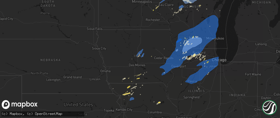
Wind
Hail
Tornado
27,165
Estimated number of impacted properties by a 1.00" hail or larger1,558
Estimated number of impacted properties by a 1.75" hail or larger1,417
Estimated number of impacted properties by a 2.50" hail or largerStorm reports in Iowa
Iowa
| Date | Description |
|---|---|
| 06/10/20266:47 PM CDT | Tree damage with power lines down. Time estimated via radar. |
| 06/10/20266:32 PM CDT | Estimated wind gust from spotter network. |
| 06/10/20266:18 PM CDT | Measured by anemometer. |
| 06/10/20266:17 PM CDT | Peak wind gust at the davenport municipal airport. |
| 06/10/20266:17 PM CDT | Several 12 to 15 inch limbs down along with trees 1 to 2 feet in diameter. Estimating 80 mph winds. |
| 06/10/20266:14 PM CDT | Estimate of 70 mph with. |
| 06/10/20265:51 PM CDT | Section of a sheet metal roof was ripped off. Picture sent via social media. Time estimated by radar. |
| 06/10/20265:25 PM CDT | Brief touchdown. |
| 06/10/20265:24 PM CDT | Report from trained spotter. |
| 06/10/20265:11 PM CDT | Confirmed tornado via broadcast media. |
| 06/10/20265:07 PM CDT | A local report indicates 60 MPH wind near 4 SE Kirkville |
| 06/10/20264:30 PM CDT | Delayed report - time estimated from radar. Received email from media relaying 2 hail in weldon. |
| 06/10/20264:12 PM CDT | Building damage per ema. |
| 06/10/20263:54 PM CDT | Local fire chief reports several intermittent touchdowns. |
| 06/10/20262:15 PM CDT | A local report indicates 58 MPH wind near 1 SSE Stanwood |
| 06/10/20261:11 PM CDT | Widespread large trees down. |
| 06/10/20261:04 PM CDT | Spotter estimated winds of 50 to 60 mph with thunderstorm. |
| 06/10/202612:54 PM CDT | Large spruce tree down. |
| 06/10/202612:54 PM CDT | Large tree snapped off near the base. Trunk diameter over a foot. |
| 06/10/202612:50 PM CDT | Branch snapped 6 inch diameter. |
| 06/10/202612:49 PM CDT | Tree branches over a foot in diameter downed. Estimated wind gust of 65 mph by car anemometer. |
| 06/10/202612:45 PM CDT | Couple trees uprooted along with many branches downed and some fence damage... Including along asbury road near bunker hill golf course. Time estimated using radar. |
| 06/10/202612:45 PM CDT | 6 inch tree limbs snapped. Time estimated by radar. |
| 06/10/202612:42 PM CDT | Tree down 1 mile west of epworth reported by off duty nws employee. |
| 06/10/202612:42 PM CDT | Many small to medium sized branches blown down. A larger size branch causing traffic issues on one downtown street. Medium sized tree uprooted in front yard 3 houses fr |
| 06/10/202612:40 PM CDT | Peak wind gust at dubuque regional airport. |
| 06/10/202612:40 PM CDT | Several trees blown down east of peosta. Reported by off duty nws employee. The time of the event was estimated using radar. |
| 06/10/202612:40 PM CDT | Em reports widespread 70-80 mph winds in the area with numerous trees down and power outages. Some traffic lights have power out on hwy 20. |
| 06/10/202612:33 PM CDT | A local report indicates 65 MPH wind near 3 ENE Monticello Munici |
| 06/10/202612:30 PM CDT | Tree down near the intersection of county rd 64 and 200th ave. Time estimated by radar. |
| 06/10/202612:20 PM CDT | Powerlines leaning. |
| 06/10/202612:15 PM CDT | Corrects previous tstm wnd gst report from 1 sse stanwood. |
| 06/10/202612:15 PM CDT | 10 inch tree limbs reported down in eden valley refuge. Time estimated by radar. |
| 06/10/202612:15 PM CDT | A local report indicates 66 MPH wind near 1 NW Park View |
| 06/10/202612:14 PM CDT | 2 inch tree limb down. The time of the event was estimated using radar. |
| 06/10/202612:07 PM CDT | Power lines down over road near intersection of 215th st and nathan bethel ave. Time estimated by radar. |
| 06/10/202611:49 AM CDT | Delayed report. Peak wind gust from a personal weather station. |
| 06/10/202611:44 AM CDT | Delayed report. Peak wind gust from a personal weather station. |
| 06/10/202611:35 AM CDT | Tree with 4 to 6 inch diameter trunk snapped at the base. |
| 06/10/202611:30 AM CDT | Wind gust measured by house anemometer and 1 inch tree limbs down. Time estimated by radar. |
| 06/10/202611:25 AM CDT | Large tree toppled one and a quarter mile south of frytown. |
| 06/10/202611:25 AM CDT | Large tree split in half... Taking down powerlines. |
| 06/10/202611:25 AM CDT | Large tree toppled at my sisters place one and a quarter mile south of frytown. |
| 06/10/202611:19 AM CDT | A local report indicates 62 MPH wind near 2 SW Williamstown |
| 06/10/202611:01 AM CDT | Tree limbs over a foot in diameter were snapped. Picture sent via social media. Time estimated by radar. |
| 06/10/202611:01 AM CDT | Delayed report. Peak wind gust from a personal weather station. |
| 06/10/202611:00 AM CDT | Large tree down in hubbard. Time estimated by radar. |
| 06/10/202611:00 AM CDT | Delayed report. Peak wind gust from a personal weather station. |
| 06/10/202610:57 AM CDT | Delayed report... Peak wind gust from the kmiw marshalltown airport asos. |
| 06/10/202610:50 AM CDT | Delayed report. Peak wind gust from a personal weather station. |
| 06/10/202610:46 AM CDT | Delayed report. Peak wind gust from personal weather station. |
| 06/10/20266:55 AM CDT | Relayed via nws chat. |
| 06/10/20266:55 AM CDT | A local report indicates 1.00 inch wind near Afton |
| 06/10/20266:55 AM CDT | Delayed report - time estimated from radar. Photo from social media with tree branches down across roadway. |
| 06/10/20266:55 AM CDT | Delayed entry - measured from kcsq. |
| 06/10/20266:53 AM CDT | Measured from personal weather station. |
| 06/10/20266:50 AM CDT | Delayed report - time estimated from radar. Received report via email of damage to several grain bins. |
| 06/10/20266:50 AM CDT | Delayed report - time estimated by radar. Received photos of damage via email. |
| 06/10/20266:50 AM CDT | Delayed report - time estimated from radar. Photo received via social media. |
| 06/10/20266:47 AM CDT | Measured from personal weather station. |
| 06/10/20266:45 AM CDT | Delayed report - time estimated from radar. Damage to machine shed on social media. |
| 06/10/20266:45 AM CDT | A local report indicates 1.00 inch wind near Creston |
| 06/10/20266:38 AM CDT | Measured from personal weather station. |
| 06/10/20266:34 AM CDT | Report from mping: quarter |
| 06/10/20266:31 AM CDT | A local report indicates 65 MPH wind near Shambaugh |
| 06/10/20266:30 AM CDT | Damage reported in corning... Will further assess source of damage. |
| 06/10/20266:30 AM CDT | Received photo of several tree limbs down. Time estimated from radar. |
| 06/10/20266:30 AM CDT | Delayed report - time estimated by radar. Received photo from trained spotter of tree limb down. |
| 06/10/20266:24 AM CDT | Delayed report. |
| 06/10/20266:24 AM CDT | Nws cooperative weather observer reports thunderstorm winds lifted the stainless steel rain gage out of its holder and tossed it around 30 ft away. Time estimated from |
| 06/10/20266:20 AM CDT | Tree down on building. Time estimated by radar. |
| 06/10/20266:18 AM CDT | Measured from personal weather station. |
| 06/10/20266:15 AM CDT | Several reports of trees and power poles down across atlantic found on social media. Time estimated from radar. |
| 06/10/20266:15 AM CDT | Delayed report of damaged grain bins blown near the interchange of us-34 and us-71... North of villisca. Time estimated with radar. |
| 06/10/20266:14 AM CDT | A local report indicates 73 MPH wind near 0.5 WNW Villisca |
| 06/10/20266:13 AM CDT | A local report indicates 58 MPH wind near 4.5 W Hepburn |
| 06/10/20266:12 AM CDT | A local report indicates 66 MPH wind near 3.8 SE Stanton |
| 06/10/20266:12 AM CDT | Emergency management report of several trees and large branches down along the page/montgomery county line. Power lines across roads. The majority of n/s roads are bloc |
| 06/10/20266:07 AM CDT | 60 mph wind estimated. Quarter sized hail and large limbs down. |
| 06/10/20266:06 AM CDT | A local report indicates 59 MPH wind near 9.0 ESE Oakland |
| 06/10/20266:01 AM CDT | A local report indicates 71 MPH wind near 4.9 SSE Coburg |
| 06/10/20265:58 AM CDT | Small tree and debris in coburg. |
| 06/10/20265:56 AM CDT | Trees blocking hwy 48 south of essex. |
| 06/10/20265:55 AM CDT | A local report indicates 63 MPH wind near 3.0 NNW Coburg |
| 06/10/20265:55 AM CDT | A local report indicates 90 MPH wind near Essex |
| 06/10/20265:47 AM CDT | A local report indicates 67 MPH wind near 2.6 NW Silver City |
| 06/10/20265:47 AM CDT | A local report indicates 80 MPH wind near 2.1 SSE Silver City |
| 06/10/20265:47 AM CDT | A local report indicates 71 MPH wind near 6.1 N Glenwood |
| 06/10/20265:46 AM CDT | A local report indicates 58 MPH wind near 3.5 N Silver City |
| 06/10/20265:45 AM CDT | Report of damage to a self-serve gas station... With one third of the roof a metal building removed by straight line winds. Time estimated from radar. |
| 06/10/20265:45 AM CDT | Delayed report received via social media of several large tree branches down in malvern... Iowa. Time estimated with radar. |
| 06/10/20265:42 AM CDT | A local report indicates 73 MPH wind near 4.2 NNE Tabor |
| 06/10/20265:40 AM CDT | A local report indicates 63 MPH wind near Glenwood |
| 06/10/20265:35 AM CDT | Delayed report of several tree branches down |
| 06/10/20265:30 AM CDT | Delayed emergency management report of a measured hailstone 3.5 inches in diameter... Shown in a photo next to a ruler. Time estimated with radar. |
| 06/10/20265:30 AM CDT | A local report indicates 2.50 inch wind near Yorktown |
| 06/10/20265:19 AM CDT | Delayed report received via social media of hail measured up to 3 inches in diameter with corresponding picture. Time estimated with radar. |
| 06/10/20265:07 AM CDT | Delayed report received via social media of hail estimated up to 2 inches in diameter. Time estimated with radar. |
| 06/09/20268:30 PM CDT | Small branches down via social media. |
| 06/09/20267:41 PM CDT | Multiple trees and power lines down. Time estimated via radar. |
| 06/09/20267:32 PM CDT | Mping report. |
| 06/09/20267:17 PM CDT | Image via social media. Time estimated from radar. |
| 06/09/20267:06 PM CDT | Received photo via social media of fallen tree on fence in altoona. |
All States Impacted by Hail Map on June 10, 2026
Cities Impacted by Hail Map on June 10, 2026
- Granton, WI
- Chili, WI
- Dorchester, WI
- Athens, WI
- Stetsonville, WI
- Edgar, WI
- Stratford, WI
- Marshfield, WI
- Neillsville, WI
- Marathon, WI
- Mosinee, WI
- Black River Falls, WI
- Medford, WI
- Land O'Lakes, WI
- Merrillan, WI
- Watersmeet, MI
- Wausau, WI
- Auburndale, WI
- Gallatin, MO
- Jameson, MO
- Pittsville, WI
- Arpin, WI
- Gower, MO
- Greenwood, WI
- Loyal, WI
- Spencer, WI
- Curtiss, WI
- Colby, WI
- Unity, WI
- Owen, WI
- Abbotsford, WI
- Schofield, WI
- Rothschild, WI
- Merrill, WI
- Brokaw, WI
- Aniwa, WI
- Ringle, WI
- Irma, WI
- Gleason, WI
- Antigo, WI
- Tigerton, WI
- Junction City, WI
- Stevens Point, WI
- Amherst Junction, WI
- Chula, MO
- Leopolis, WI
- Caroline, WI
- Marion, WI
- Iola, WI
- Hamilton, MO
- Gresham, WI
- Shawano, WI
- Ogdensburg, WI
- Manawa, WI
- Clintonville, WI
- Wheeling, MO
- Meadville, MO
- Tilleda, WI
- Crivitz, WI
- Embarrass, WI
- Shiocton, WI
- Bonduel, WI
- Pulaski, WI
- Green Castle, MO
- Black Creek, WI
- Seymour, WI
- Woodward, IA
- Ogden, IA
- Boone, IA
- Waupaca, WI
- Amherst, WI
- Nekoosa, WI
- Nevada, IA
- Ames, IA
- Nelsonville, WI
- Bancroft, WI
- Story City, IA
- Gilbert, IA
- Roland, IA
- Ellsworth, IA
- Radcliffe, IA
- McCallsburg, IA
- Hubbard, IA
- Garden City, IA
- Zearing, IA
- Colo, IA
- State Center, IA
- Saint Anthony, IA
- Clemons, IA
- Union, IA
- New Providence, IA
- Scandinavia, WI
- Eldora, IA
- Iowa Falls, IA
- Montour, IA
- Toledo, IA
- Tama, IA
- Mount Pleasant, IA
- Wayland, IA
- Almond, WI
- Ainsworth, IA
- Kewaunee, WI
- Fairfield, IA
- Lockridge, IA
- Brighton, IA
- Crawfordsville, IA
- Winfield, IA
- Olds, IA
- Columbus Junction, IA
- Columbus City, IA
- Conesville, IA
- Algoma, WI
- Clutier, IA
- Craig, MO
- Letts, IA
- Muscatine, IA
- Wapello, IA
- Fruitland, IA
- Fairfax, MO
- Washington, IA
- Riverside, IA
- Kalona, IA
- Wellman, IA
- Lone Tree, IA
- Keota, IA
- Nichols, IA
- Hills, IA
- Iowa City, IA
- West Liberty, IA
- West Branch, IA
- Solon, IA
- Atalissa, IA
- Illinois City, IL
- Moscow, IA
- Tipton, IA
- Wilton, IA
- Cowgill, MO
- Kingston, MO
- Polo, MO
- Cameron, MO
- Kidder, MO
- Breckenridge, MO
- Braymer, MO
- Goodhue, MN
- Lake City, MN
- Red Wing, MN
- Cedar Rapids, IA
- Durant, IA
- Montpelier, IA
- Blue Grass, IA
- Lisbon, IA
- Stockton, IA
- Taylor Ridge, IL
- Walcott, IA
- Buffalo, IA
- Rock Island, IL
- Davenport, IA
- Mount Vernon, IA
- Bennett, IA
- Milan, IL
- Moline, IL
- New Liberty, IA
- Mechanicsville, IA
- Dixon, IA
- Donahue, IA
- Calamus, IA
- Dunkerton, IA
- Jesup, IA
- Waterloo, IA
- Bettendorf, IA
- Clarence, IA
- Stanwood, IA
- Hampton, IL
- Port Byron, IL
- East Moline, IL
- Long Grove, IA
- Rapids City, IL
- Eldridge, IA
- Lowden, IA
- Pleasant Valley, IA
- Wheatland, IA
- Le Claire, IA
- Lost Nation, IA
- Morley, IA
- Anamosa, IA
- Cascade, IA
- Wyoming, IA
- Oxford Junction, IA
- Onslow, IA
- Baldwin, IA
- Olin, IA
- Grand Mound, IA
- Princeton, IA
- Center Junction, IA
- De Witt, IA
- Monmouth, IA
- Monticello, IA
- Delmar, IA
- Maquoketa, IA
- Bernard, IA
- Camanche, IA
- Welton, IA
- Charlotte, IA
- McCausland, IA
- Cordova, IL
- Zwingle, IA
- Elmwood, WI
- Maiden Rock, WI
- Stockholm, WI
- Plum City, WI
- Manchester, IA
- Masonville, IA
- Winthrop, IA
- Appomattox, VA
- La Motte, IA
- Goose Lake, IA
- Fulton, IL
- Clinton, IA
- Andrew, IA
- Bryant, IA
- Low Moor, IA
- Albany, IL
- Spragueville, IA
- Preston, IA
- Bellevue, IA
- Peosta, IA
- Dubuque, IA
- Miles, IA
- East Dubuque, IL
- Arkansaw, WI
- Dundee, IA
- Menomonie, WI
- Eau Galle, WI
- Hazel Green, WI
- Cuba City, WI
- Sabula, IA
- Galena, IL
- Teeds Grove, IA
- Savanna, IL
- Hanover, IL
- Kieler, WI
- Thomson, IL
- Morrison, IL
- Dickeyville, WI
- Platteville, WI
- Potosi, WI
- Elizabeth, IL
- Shullsburg, WI
- Scales Mound, IL
- Benton, WI
- Fargo, ND
- Moorhead, MN
- Mount Carroll, IL
- Stockton, IL
- Lanark, IL
- Belmont, WI
- Apple River, IL
- Pearl City, IL
- Mineral Point, WI
- Darlington, WI
- Georgetown, MN
- Chadwick, IL
- Sterling, IL
- Gratiot, WI
- Clarence, MO
- Colfax, WI
- Bloomer, WI
- New Auburn, WI
- Kent, IL
- Warren, IL
- Rewey, WI
- Lena, IL
- Nora, IL
- Shannon, IL
- Winslow, IL
- Dodgeville, WI
- Blanchardville, WI
- Freeport, IL
- Argyle, WI
- Hollandale, WI
- South Wayne, WI
- Baileyville, IL
- Browntown, WI
- Forreston, IL
- McConnell, IL
- Lancaster, WI
- Newfolden, MN
- Middle River, MN
- Milledgeville, IL
- Mount Hope, WI
- Cairo, MO
- Livingston, WI
- Stitzer, WI
- Fennimore, WI
- Linden, WI
- Montfort, WI
- Cobb, WI
- Highland, WI
- Muscoda, WI
- Woodford, WI
- Monroe, WI
- Orangeville, IL
- Macomb, IL
- Sherrill, IA
- Durango, IA
- Strathcona, MN
- Wannaska, MN
- Badger, MN
- Roseau, MN
- Mount Morris, IL
- Leaf River, IL
- Polo, IL
- German Valley, IL
- Thief River Falls, MN
- Osseo, WI
- Paris, MO
- Shelbina, MO
- Marietta, IL
- Blue River, WI
- Boscobel, WI
- Arena, WI
- Ridgeway, WI
- Avoca, WI
- Dakota, IL
- Lone Rock, WI
- Cedarville, IL
- Barneveld, WI
- Spring Green, WI
- Ridott, IL
- Rockford, IL
- Winnebago, IL
- Pecatonica, IL
- Rock City, IL
- Byron, IL
- North Freedom, WI
- Loganville, WI
- Hillpoint, WI
- Richland Center, WI
- Monticello, WI
- Plain, WI
- Belleville, WI
- Mount Horeb, WI
- Black Earth, WI
- New Glarus, WI
- Blue Mounds, WI
- Durand, IL
- Prairie Du Sac, WI
- Mazomanie, WI
- Brodhead, WI
- Davis, IL
- Sauk City, WI
- Juda, WI
- Gotham, WI
- Cazenovia, WI
- Gary, MN
- Fairchild, WI
- Fertile, MN
- Oregon, IL
- Red Lake Falls, MN
- Alma Center, WI
- Madison, WI
- Verona, WI
- Augusta, WI
- Middleton, WI
- Evansville, WI
- Cross Plains, WI
- Oregon, WI
- Albany, WI
- Orfordville, WI
- Lodi, WI
- Merrimac, WI
- Waunakee, WI
- Dane, WI
- Brooklyn, WI
- Baraboo, WI
- Deforest, WI
- Beloit, WI
- Footville, WI
- Rockton, IL
- Janesville, WI
- Shirland, IL
- South Beloit, IL
- Stoughton, WI
- Mcfarland, WI
- Goodridge, MN
- Melrose, WI
- Hillsboro, WI
- Amboy, IL
- Franklin Grove, IL
- Dixon, IL
- Eldena, IL
- Lenox, IA
- Sharpsburg, IA
- Chana, IL
- Cottage Grove, WI
- Humbird, WI
- Stillman Valley, IL
- Deerfield, WI
- Milton, WI
- Edgerton, WI
- Cambridge, WI
- Bedford, IA
- Rochelle, IL
- Gatzke, MN
- Grygla, MN
- South Boston, VA
- Clearfield, IA
- Sun Prairie, WI
- Monroe Center, IL
- Davis Junction, IL
- Halifax, VA
- Princeville, IL
- Fort Atkinson, WI
- Lake Mills, WI
- Diagonal, IA
- New Hampton, MO
- Bethany, MO
- Waterman, IL
- Steward, IL
- Mcintosh, MN
- Trail, MN
- Fosston, MN
- Esmond, IL
- Malta, IL
- Clare, IL
- Jamesport, MO
- Lindenwood, IL
- Cherry Valley, IL
- Kirkland, IL
- Gully, MN
- Afton, WI
- Windsor, WI
- Marshall, WI
- Waterloo, WI
- Loves Park, IL
- Jefferson, WI
- Clinton, WI
- Whitewater, WI
- Roscoe, IL
- Watertown, WI
- Machesney Park, IL
- Johnson Creek, WI
- Caledonia, IL
- Sharon, WI
- Helenville, WI
- Avalon, WI
- Darien, WI
- Delavan, WI
- Poplar Grove, IL
- Capron, IL
- Belvidere, IL
- Salol, MN
- Dekalb, IL
- Tingley, IA
- Shannon City, IA
- Nelson, VA
- Buffalo Junction, VA
- Murray, IA
- Afton, IA
- Thayer, IA
- Ellston, IA
- Shabbona, IL
- Earlville, IL
- Genoa, IL
- Sycamore, IL
- Kingston, IL
- Cortland, IL
- Maple Park, IL
- Mount Ayr, IA
- Virgilina, VA
- Savannah, MO
- Saint Joseph, MO
- Grant City, MO
- Lee, IL
- Yates City, IL
- Elmwood, IL
- Canton, IL
- Farmington, IL
- Morton, IL
- Mapleton, IL
- East Peoria, IL
- Glasford, IL
- Groveland, IL
- Hanna City, IL
- Creve Coeur, IL
- Trivoli, IL
- Pekin, IL
- Peoria, IL
- Peoria Heights, IL
- Washington, IL
- Brimfield, IL
- Metamora, IL
- Edwards, IL
- Goodfield, IL
- Deer Creek, IL
- Lengby, MN
- Danvers, IL
- Bloomington, IL
- Big Rock, IL
- Hinckley, IL
- Elburn, IL
- Sugar Grove, IL
- Balmorhea, TX
- Naytahwaush, MN
- Mahnomen, MN
- Helena, MO
- Osceola, IA
- Grand River, IA
- Lamoni, IA
- Van Wert, IA
- Winchester, IL
- Murrayville, IL
- Plano, IL
- Weldon, IA
- Hatfield, MO
- Kellerton, IA
- Bolckow, MO
- Rea, MO
- Guilford, MO
- Union Star, MO
- Cosby, MO
- Ridgeway, MO
- Somonauk, IL
- Sandwich, IL
- Hampshire, IL
- Dunlap, IL
- Mossville, IL
- Edelstein, IL
- Chillicothe, IL
- Speer, IL
- Sparland, IL
- Lowpoint, IL
- Eureka, IL
- Granville, IL
- Lacon, IL
- Hennepin, IL
- Magnolia, IL
- Putnam, IL
- Henry, IL
- La Rose, IL
- McNabb, IL
- Washburn, IL
- Roanoke, IL
- Varna, IL
- Toluca, IL
- Rutland, IL
- Secor, IL
- Long Point, IL
- Tonica, IL
- Congerville, IL
- Wenona, IL
- Ransom, IL
- El Paso, IL
- Dana, IL
- Ancona, IL
- Lostant, IL
- Grand Ridge, IL
- Minonk, IL
- Benson, IL
- Streator, IL
- Leonore, IL
- Cornell, IL
- Flanagan, IL
- Seneca, IL
- Blackstone, IL
- Ottawa, IL
- Oglesby, IL
- Gridley, IL
- Pontiac, IL
- Mendota, IL
- La Moille, IL
- Paw Paw, IL
- Compton, IL
- Sublette, IL
- Moberly, MO
- King City, MO
- Stanberry, MO
- Bristol, IL
- Yorkville, IL
- Aurora, IL
- Montgomery, IL
- Cainsville, MO
- Chariton, IA
- Lucas, IA
- Woodburn, IA
- Madison, MO
- Clark, MO
- Newark, IL
- Amity, MO
- Mooseheart, IL
- Batavia, IL
- Geneva, IL
- North Aurora, IL
- Bagley, MN
- Princeton, MO
- Jacksonville, IL
- Elgin, IL
- Fort Davis, TX
- Eden, WI
- Clarksdale, MO
- Sheridan, IL
- Leland, IL
- Utica, IL
- Peru, IL
- Cedar Point, IL
- Wedron, IL
- Serena, IL
- Marseilles, IL
- Maysville, MO
- Waubun, MN
- Ponsford, MN
- Decatur, IA
- Leon, IA
- Holliday, MO
- Oak Creek, WI
- McLean, IL
- Waynesville, IL
- Denver, MO
- Warrenville, IL
- Saint Charles, IL
- West Chicago, IL
- Oswego, IL
- Winfield, IL
- Plainfield, IL
- Naperville, IL
- Carol Stream, IL
- Gardner, IL
- Dwight, IL
- Derby, IA
- Odell, IL
- Mequon, WI
- Milwaukee, WI
- Plainfield, WI
- Darlington, MO
- Albany, MO
- Gentry, MO
- Graymont, IL
- Coal City, IL
- Elwood, IL
- Channahon, IL
- Millbrook, IL
- Minooka, IL
- Mazon, IL
- Kinsman, IL
- Wilmington, IL
- Braidwood, IL
- Braceville, IL
- Millington, IL
- Morris, IL
- Verona, IL
- Lombard, IL
- Chicago, IL
- Lisle, IL
- Homer Glen, IL
- Lincolnwood, IL
- Des Plaines, IL
- Stone Park, IL
- Evanston, IL
- Glendale Heights, IL
- Wheaton, IL
- Western Springs, IL
- Park Ridge, IL
- Oak Park, IL
- Broadview, IL
- Hines, IL
- Palos Park, IL
- Maywood, IL
- Willow Springs, IL
- Franklin Park, IL
- Lyons, IL
- Bensenville, IL
- Lockport, IL
- Justice, IL
- Brookfield, IL
- Romeoville, IL
- River Forest, IL
- La Grange Park, IL
- Clarendon Hills, IL
- Orland Park, IL
- Westmont, IL
- Berwyn, IL
- Bridgeview, IL
- River Grove, IL
- Skokie, IL
- Hillside, IL
- Manhattan, IL
- Westchester, IL
- Addison, IL
- Woodridge, IL
- Villa Park, IL
- Elmwood Park, IL
- Harwood Heights, IL
- Shorewood, IL
- Summit Argo, IL
- Hinsdale, IL
- Forest Park, IL
- Darien, IL
- Bloomingdale, IL
- Bolingbrook, IL
- Riverside, IL
- Cicero, IL
- Oak Brook, IL
- Glen Ellyn, IL
- Joliet, IL
- Wood Dale, IL
- New Lenox, IL
- Schiller Park, IL
- Niles, IL
- Bellwood, IL
- Melrose Park, IL
- Crest Hill, IL
- Willowbrook, IL
- Elmhurst, IL
- Lemont, IL
- Berkeley, IL
- Downers Grove, IL
- La Grange, IL
- Hickory Hills, IL
- Mokena, IL
- Itasca, IL
- Hanover Park, IL
- Russell, IA
- Humeston, IA
- Martinsville, MO
- Pattonsburg, MO
- Weatherby, MO
- Emington, IL
- Cabery, IL
- Bussey, IA
- Gilman City, MO
- Garden Grove, IA
- Monroe City, MO
- Stoutsville, MO
- Omro, WI
- Markesan, WI
- Eldorado, WI
- Clyman, WI
- Friesland, WI
- Rosendale, WI
- Morrisonville, WI
- Columbus, WI
- Waupun, WI
- Lowell, WI
- Oshkosh, WI
- Brandon, WI
- Pickett, WI
- Rio, WI
- Fox Lake, WI
- Arlington, WI
- Horicon, WI
- Juneau, WI
- Fairwater, WI
- Ripon, WI
- Beaver Dam, WI
- Randolph, WI
- Fall River, WI
- Burnett, WI
- Doylestown, WI
- Poynette, WI
- Reeseville, WI
- Cambria, WI
- Blue Island, IL
- Evergreen Park, IL
- Palos Heights, IL
- Oak Lawn, IL
- Frankfort, IL
- Tinley Park, IL
- Chicago Ridge, IL
- Robbins, IL
- Hometown, IL
- Oak Forest, IL
- Crestwood, IL
- Midlothian, IL
- Burbank, IL
- Country Club Hills, IL
- Markham, IL
- Palos Hills, IL
- Worth, IL
- Alsip, IL
- Kingston, WI
- Montello, WI
- Dalton, WI
- Berlin, WI
- Pardeeville, WI
- Marquette, WI
- Green Lake, WI
- Portage, WI
- Princeton, WI
- Wyocena, WI
- Lovilia, IA
- Rock Springs, WI
- Wisconsin Dells, WI
- Reedsburg, WI
- Malone, WI
- Fond Du Lac, WI
- Oakfield, WI
- Hustisford, WI
- Dousman, WI
- Elkhart Lake, WI
- New Holstein, WI
- Lebanon, WI
- Theresa, WI
- West Bend, WI
- Lomira, WI
- Saint Cloud, WI
- Hilbert, WI
- Palmyra, WI
- Chilton, WI
- Rubicon, WI
- Ashippun, WI
- Neosho, WI
- Kiel, WI
- Allenton, WI
- Campbellsport, WI
- Kewaskum, WI
- Reedsville, WI
- Hartford, WI
- Potter, WI
- Van Dyne, WI
- Elkhorn, WI
- Iron Ridge, WI
- Sullivan, WI
- Stockbridge, WI
- Glenbeulah, WI
- Brownsville, WI
- Brillion, WI
- Ixonia, WI
- Mayville, WI
- Oconomowoc, WI
- Collins, WI
- Mount Calvary, WI
- Menasha, WI
- Forest Junction, WI
- Sherwood, WI
- Greenleaf, WI
- Neenah, WI
- Melrose, IA
- Corydon, IA
- Pecos, TX
- Hamilton, IA
- Shevlin, MN
- Eagleville, MO
- Hancock, MN
- Cyrus, MN
- Starbuck, MN
- Solway, MN
- Unionville, MO
- Lucerne, MO
- Saint Nazianz, WI
- Delafield, WI
- Eagle, WI
- Cascade, WI
- Hartland, WI
- Elm Grove, WI
- Saukville, WI
- Sheboygan Falls, WI
- Wales, WI
- Burlington, WI
- Menomonee Falls, WI
- Sussex, WI
- Lannon, WI
- Grafton, WI
- Muskego, WI
- Cedarburg, WI
- Slinger, WI
- Colgate, WI
- Brookfield, WI
- Jackson, WI
- Pewaukee, WI
- New Berlin, WI
- Random Lake, WI
- Butler, WI
- Adell, WI
- Belgium, WI
- Mukwonago, WI
- Valders, WI
- Okauchee, WI
- North Prairie, WI
- Waldo, WI
- East Troy, WI
- Nashotah, WI
- Big Bend, WI
- Walworth, WI
- Germantown, WI
- Richfield, WI
- Plymouth, WI
- Hubertus, WI
- Fredonia, WI
- Waukesha, WI
- Coffey, MO
- Altamont, MO
- McFall, MO
- Waterford, WI
- Oostburg, WI
- Cleveland, WI
- Port Washington, WI
- Cedar Grove, WI
- Hales Corners, WI
- Kohler, WI
- Newton, WI
- Whitelaw, WI
- Sheboygan, WI
- Manitowoc, WI
- Sturgeon Lake, MN
- Moose Lake, MN
- Clinton, IL
- Pella, IA
- Bemidji, MN
- Boyceville, WI
- Pollock, MO
- Powersville, MO
- Wisconsin Rapids, WI
- Rudolph, WI
- Custer, WI
- Rosholt, WI
- Wittenberg, WI
- South English, IA
- Webster, IA
- Dewitt, IL
- Menahga, MN
- Durand, WI
- Byron, MN
- Davis City, IA
- Blythedale, MO
- Courtenay, ND
- Buchanan, ND
- Millerton, IA
- Harper, IA
- Glenwood, MN
- Lowry, MN
- Rochester, MN
- Lineville, IA
- Sebeka, MN
- Kelliher, MN
- Hines, MN
- Tenstrike, MN
- Waskish, MN
- Bluffton, MN
- Deer Creek, MN
- Wadena, MN
- Trenton, MO
- Winston, MO
- Pepin, WI
- Bowler, WI
- North English, IA
- Park Rapids, MN
- Van Horn, TX
- Albia, IA
- Illiopolis, IL
- New York Mills, MN
- New Sharon, IA
- Henning, MN
- Verndale, MN
- Blackduck, MN
- Villard, MN
- Floodwood, MN
- Montezuma, IA
- Eyota, MN
- Mystic, IA
- Ottumwa, IA
- Latham, IL
- Warrensburg, IL
- Niantic, IL
- Morrisonville, IL
- Harvel, IL
- Hedrick, IA
- Spickard, MO
- Butler, IL
- Litchfield, IL
- Birnamwood, WI
- Alexandria, MN
- Osakis, MN
- Sauk Centre, MN
- West Union, MN
- Grey Eagle, MN
- Long Prairie, MN
- Big Falls, MN
- Raymond, IL
- Moravia, IA
- Elgin, MN
- Richland, IA
- Ollie, IA
- Galt, MO
- Laredo, MO
- Packwood, IA
- Nokomis, IL
- Exline, IA
- Moulton, IA
- Burtrum, MN
- Posen, IL
- Thornton, IL
- Gary, IN
- Whiting, IN
- Dolton, IL
- Harvey, IL
- Lansing, IL
- Riverdale, IL
- Hammond, IN
- South Holland, IL
- Hazel Crest, IL
- Calumet City, IL
- East Chicago, IN
- Matteson, IL
- Homewood, IL
- Westville, IN
- Valparaiso, IN
- Wanatah, IN
- Union Mills, IN
- Swanville, MN
- La Porte, IN
- Hanna, IN
- Hamlet, IN
- Kingsford Heights, IN
- Atlanta, MO
- Petersburg, ND
- Humphreys, MO
- Guthrie Center, IA
- Pomeroy, OH
- Langsville, OH
- Rutland, OH
- Staples, MN
- Hibbing, MN
- Stewartville, MN
- Racine, MN
- Spring Valley, MN
- Casey, IA
- Meadowlands, MN
- Milan, MO
- Browning, MO
- Sodus, MI
- Coloma, MI
- Watervliet, MI
- Covert, MI
- Saint Joseph, MI
- Stevensville, MI
- Benton Harbor, MI
- Eau Claire, MI
- South Haven, MI
- Hartford, MI
- Grand Junction, MI
- Lawrence, MI
- Bangor, MI
- Fennville, MI
- Pullman, MI
- Douglas, MI
- Holland, MI
- Saugatuck, MI
- Hamilton, MI
- Macatawa, MI
- Northome, MN
- Forest Lake, MN
- Stacy, MN
- Wyoming, MN
- Bloomfield, IA
- Dearborn, MI
- Dearborn Heights, MI
- White Cloud, KS
- Westpoint, IN
- Menlo, IA
- Cedar, MN
- Bouton, IA
- Minburn, IA
- Alma, WI
- Oregon, MO
- Maitland, MO
- Graham, MO
- Stuart, IA
- Independence, WI
- Dallas Center, IA
- Winona, MN
- Green City, MO
- Chatfield, MN
- Wykoff, MN
- La Belle, MO
- Knox City, MO
- Barnard, MO
- Chisago City, MN
- Middleton, MI
- Larimore, ND
- Taylor, MI
- Mount Airy, NC
- Houston, MN
- Lafayette, IN
- Salina, KS
- Novelty, MO
- Edina, MO
- Udell, IA
- Mondovi, WI
- Detroit, MI
- Mound City, MO
- Monroeville, OH
- Norwalk, OH
- Dexter, IA
- Tolono, IL
- Philo, IL
- Plano, IA
- Fremont, IA
- Holyoke, MN
- Lindstrom, MN
- Shafer, MN
- Center City, MN
- Dresser, WI
- Taylors Falls, MN
- Saint Croix Falls, WI
- Downing, MO
- Leonardville, KS
- Green, KS
- Bena, MN
- Sidney, IL
- Fontanelle, IA
- Greenfield, IA
- Cincinnati, IA
- Adel, IA
- Winigan, MO
- Grimes, IA
- Adair, IA
- North Branch, MN
- Randolph, KS
- Ithaca, MI
- Centerville, IA
- Seymour, IA
- Hugo, MN
- Aitkin, MN
- Maryville, MO
- Skidmore, MO
- Harris, MN
- Bennington, KS
- New Cambria, KS
- Wellington, OH
- New London, OH
- Solomon, KS
- Longford, KS
- Clay Center, KS
- Carleton, MI
- Redfield, IA
- Osage, MN
- Centuria, WI
- Mercer, MO
- Lewistown, MO
- Allen Park, MI
- Inkster, MI
- Highland Park, MI
- Hamtramck, MI
- Trempealeau, WI
- Dakota, MN
- Galesville, WI
- Fountain, MN
- Earlham, IA
- Side Lake, MN
- New Boston, MO
- Purdin, MO
- Nevis, MN
- Lanesboro, MN
- Wakefield, KS
- Cook, MN
- Great Bend, KS
- Milltown, WI
- Luck, WI
- Williamstown, MO
- Kahoka, MO
- Angora, MN
- Granger, IA
- De Soto, IA
- Anita, IA
- Conception Junction, MO
- Effie, MN
- Novinger, MO
- Ellinwood, KS
- Holmen, WI
- Onalaska, WI
- Scandia, MN
- Marine On Saint Croix, MN
- Hiawatha, KS
- Melvindale, MI
- Worth, MO
- Rockwell, IA
- Redding, IA
- Deer River, MN
- Peterson, MN
- Conception, MO
- Kirksville, MO
- Tescott, KS
- Newark, MO
- Saint Patrick, MO
- Shelbyville, MO
- Bethel, MO
- Leonard, MO
- Rosendale, MO
- Roseville, MI
- Warren, MI
- Olsburg, KS
- Delphi, IN
- Palmer, IL
- Orr, MN
- Hixton, WI
- Bovey, MN
- Wadsworth, OH
- Abilene, KS
- Claflin, KS
- Bushton, KS
- Littlefork, MN
- Bigfork, MN
- Tamarack, MN
- La Crosse, WI
- Mcgregor, MN
- Balsam Lake, WI
- Amery, WI
- Fraser, MI
- Mindoro, WI
- Belding, MI
- Ettrick, WI
- West Des Moines, IA
- Onamia, MN
- Cohasset, MN
- Urbandale, IA
- Rulo, NE
- Collins, OH
- Fountain City, WI
- Hudson, KS
- Dayton, IA
- Waukee, IA
- Arcadia, WI
- Van Meter, IA
- Cumming, IA
- Allegan, MI
- Bloomingdale, MI
- Hopkins, MI
- Zeeland, MI
- North Judson, IN
- Knox, IN
- La Crosse, IN
- San Pierre, IN
- Wheatfield, IN
- Kouts, IN
- New Richmond, WI
- Webster City, IA
- Huron, OH
- Berlin Heights, OH
- Vermilion, OH
- Ravenwood, MO
- Kettle River, MN
- Doylestown, OH
- Barberton, OH
- Harris, MO
- Newtown, MO
- West Salem, WI
- Rushford, MN
- Plymouth, IN
- Grovertown, IN
- Walkerton, IN
- Des Moines, IA
- Norwalk, IA
- Talmage, KS
- Comstock, WI
- Turtle Lake, WI
- Lyons, KS
- Geneseo, KS
- Chase, KS
- Manhattan, KS
- McGrath, MN
- Finlayson, MN
- Willow River, MN
- Macon, MO
- Pilot Mound, IA
- Stratford, IA
- Hurdland, MO
- Wright, MN
- La Plata, MO
- Ewing, MO
- Brashear, MO
- Gibbs, MO
- Wakeman, OH
- Stanton, MI
- Edmore, MI
- Clear Lake, WI
- Warba, MN
- Askov, MN
- North Liberty, IN
- Lakeville, IN
- Dougherty, IA
- Sheffield, IA
- Bremen, IN
- Raymond, KS
- Almena, WI
- Cumberland, WI
- Sandstone, MN
- Stanhope, IA
- Jewell, IA
- Kamrar, IA
- Saint Johns, MI
- Enterprise, KS
- Marble Rock, IA
- Greene, IA
- Deer Park, WI
- Floyd, IA
- Rudd, IA
- Cromwell, MN
- Allerton, IA
- Forest City, MO
- Clyde, MO
- Parnell, MO
- Osage, IA
- Monticello, MO
- Marble, MN
- Calumet, MN
- Medina, OH
- Ashley, MI
- Lagrange, OH
- Rock Falls, IL
- Frankfort, KS
- Glenwood City, WI
- Barron, WI
- Little River, KS
- Sterling, KS
- Alden, KS
- Brookville, KS
- Canton, MO
- Rutledge, MO
- Kerrick, MN
- Elyria, OH
- Saint George, KS
- Chapman, KS
- Amherst, OH
- Bruno, MN
- Harmon, IL
- Ellsworth, KS
- Tomah, WI
- Blairsburg, IA
- Star Prairie, WI
- Clayton, WI
- Prairie Farm, WI
- Centralia, KS
- Vermillion, KS
- Akron, OH
- Sheridan, MO
- Nashwauk, MN
- Newton, IA
- Colfax, IA
- Prairie City, IA
- Williams, IA
- Litchfield, OH
- Grafton, OH
- Riceville, IA
- Pengilly, MN
- Caledonia, MN
- Westmoreland, KS
- Wamego, KS
- Wyaconda, MO
- Orient, IA
- Oberlin, OH
- Marcell, MN
- Kipton, OH
- Jacobson, MN
- Orchard, IA
- Rice Lake, WI
- Cameron, WI
- Windom, KS
- Macksburg, IA
- Pleasantville, IA
- Swan, IA
- Alden, IA
- Lorain, OH
- Seneca, KS
- Woodbine, KS
- Camp Douglas, WI
- Fillmore, MO
- Munger, MI
- Bay City, MI
- Saginaw, MI
- Lorimor, IA
- Winterset, IA
- Greenbush, MN
- New Market, IA
- Sheffield Lake, OH
- Morrill, KS
- Belvue, KS
- Junction City, KS
- Gypsum, KS
- Paxico, KS
- Carlton, MN
- Amazonia, MO
- Greentop, MO
- Reese, MI
- Fairgrove, MI
- Uniontown, OH
- Booneville, IA
- Sabetha, KS
- Milford, KS
- Clarksville, IA
- Hutchinson, KS
- Inman, KS
- Herington, KS
- Hope, KS
- Saint Charles, MN
- Queen City, MO
- Baring, MO
- Cleveland, OH
- Dover, MN
- Frazee, MN
- North Canton, OH
- Plainfield, IA
- Waverly, IA
- Linden, MI
- South Elgin, IL
- Worthington, MO
- Ackley, IA
- Altura, MN
- White City, KS
- New Lisbon, WI
- Necedah, WI
- Aplington, IA
- Dumont, IA
- Kesley, IA
- Arbela, MO
- Memphis, MO
- Warsaw, IL
- Mcpherson, KS
- Blockton, IA
- Allison, IA
- Fenton, MI
- Luray, MO
- Eastlake, OH
- Wickliffe, OH
- Euclid, OH
- Willoughby, OH
- Alma, KS
- Sutter, IL
- Ottertail, MN
- Plover, WI
- Silvis, IL
- Carbon Cliff, IL
- Colona, IL
- Erie, IL
- Chardon, OH
- Mentor, OH
- Hillsdale, IL
- Fenton, IL
- Huntsburg, OH
- Montville, OH
- Painesville, OH
- Windsor, OH
- Geneseo, IL
- Madison, OH
- Thompson, OH
- Prophetstown, IL
- Hooppole, IL
- Topeka, KS
- Maple Hill, KS
- Rome, OH
- Rock Creek, OH
- Geneva, OH
- Atkinson, IL
- Annawan, IL
- Mineral, IL
- Tampico, IL
- Sheffield, IL
- New Bedford, IL
- Walnut, IL
- Princeton, IL
- Manlius, IL
- Wyanet, IL
- Ohio, IL
- Hinckley, OH
- Gorin, MO
- Riley, KS
- Fort Riley, KS
- Orwell, OH
- Ferryville, WI
- Oelwein, IA
- Fairbank, IA
- Sumner, IA
- Westgate, IA
- Readlyn, IA
- Oran, IA
- Austinburg, OH
- Benton, IA
- Wayland, MO
- Viroqua, WI
- Alexandria, MO
- Tampa, KS
- Ramona, KS
- Eskridge, KS
- Jal, NM
- Conneaut, OH
- Ashtabula, OH
- North Kingsville, OH
- Richfield, OH
- Wilsey, KS
- Jefferson, OH
- Ipava, IL
- Lost Springs, KS
- Burdick, KS
- Maynard, IA
- Blair, WI
- Whitehall, WI
- Basco, IL
- Carthage, IL
- Soldiers Grove, WI
- Council Grove, KS
- Good Hope, IL
- Blandinsville, IL
- Sciota, IL
- Plymouth, IL
- West Springfield, PA
- East Springfield, PA
- Kingsville, OH
- Burlington Junction, MO
- Pickering, MO
- Cornell, WI
- Lewistown, IL
- Sutton, WV
- Lincolnville, KS
- Hopkins, MO
- Avon, IL
- Bushnell, IL
- Bardolph, IL
- Adair, IL
- Prairie City, IL
- Table Grove, IL
- Smithfield, IL
- Stanley, WI
- Thorp, WI
- Tennessee, IL
- Colchester, IL
- Strong City, KS
- Cuba, IL
- Prairie Du Chien, WI
- La Crescent, MN
- La Grange, MO
- Jamestown, PA
- Hartstown, PA
- Buhler, KS
- Cooperstown, ND
- Hannaford, ND
- Emporia, KS
- Conneaut Lake, PA
- Atlantic, PA
- Havana, IL
- Lisbon, OH
- Lublin, WI
- Cottonwood Falls, KS
- Topeka, IL
- Woodman, WI
- Liverpool, IL
- Linneus, MO
- Erie, PA
- Harborcreek, PA
- North East, PA
- Cochranton, PA
- Nickerson, KS
- South Hutchinson, KS
- Livonia, MO
- Ripley, NY
- Titusville, PA
- Easton, IL
- Bath, IL
- Glenwood, MO
- Rochester, PA
- New Brighton, PA
- Ethel, MO
- Elmer, MO
- Brookfield, MO
- Westfield, NY
- Zelienople, PA
- Evans City, PA
- Cranberry Township, PA
- Burrton, KS
- Moundridge, KS
- Kilbourne, IL
- Bucklin, MO
- New Cambria, MO
- Callao, MO
- San Jose, IL
- New Holland, IL
- Halstead, KS
- Butler, PA
- Mason City, IL
- Williamsville, IL
- Middletown, IL
- Lincoln, IL
- Mount Pulaski, IL
- Greenview, IL
- Beason, IL
- Sherman, IL
- Riverton, IL
- Cantrall, IL
- Athens, IL
- Elkhart, IL
- Petersburg, IL
- Buffalo, IL
- Springfield, IL
- Hesston, KS
- Newton, KS
- Sedgwick, KS
- Stanford, IL
- Templeton, PA
- North Newton, KS
- Atlanta, IL
- Kittanning, PA
- New Bethlehem, PA
- Dawson, IL
- Mechanicsburg, IL
- Mount Auburn, IL
- Decatur, IL
- Rochester, IL
- Pleasant Plains, IL
- Chestnut, IL
- Stonington, IL
- Macon, IL
- Harristown, IL
- Forsyth, IL
- Boody, IL
- Moweaqua, IL
- Maroa, IL
- Argenta, IL
- Blue Mound, IL
- Kenney, IL
- Oreana, IL
- Edinburg, IL
- Cisco, IL
- Taylorville, IL
- Hunnewell, MO
- Emden, MO
- Dayton, PA
- Weldon, IL
- Lane, IL
- Monticello, IL
- De Land, IL
- Mt Zion, IL
- Bondville, IL
- Cerro Gordo, IL
- Pesotum, IL
- Gays, IL
- La Place, IL
- Villa Grove, IL
- Ivesdale, IL
- Mansfield, IL
- Sadorus, IL
- Dalton City, IL
- Arcola, IL
- Sullivan, IL
- Milmine, IL
- Tuscola, IL
- Bement, IL
- Champaign, IL
- Saint Joseph, IL
- Atwood, IL
- Urbana, IL
- Hammond, IL
- Savoy, IL
- Windsor, IL
- Lovington, IL
- Arthur, IL
- Humboldt, IL
- White Heath, IL
- Bethany, IL
- Mattoon, IL
- Seymour, IL
- Findlay, IL
- Palmyra, MO
- Hannibal, MO
- Farmersville, IL
- Hull, IL
- New London, MO
- West Lafayette, IN
- Maywood, NE
- Moorefield, NE
- Curtis, NE
- Eustis, NE
- Cozad, NE
- Farnam, NE
- Elwood, NE
- Lexington, NE
- Overton, NE
- Kearney, NE
- Gibbon, NE
- Shelton, NE
- Wood River, NE
- Alda, NE
- Doniphan, NE
- Bertrand, NE
- Aurora, NE
- Giltner, NE
- Odessa, NE
- Elm Creek, NE
- Smithfield, NE
- Riverdale, NE
- Ravenna, NE
- Pleasanton, NE
- Hastings, NE
- Phillips, NE
- Amherst, NE
- Grand Island, NE
- Holdrege, NE
- Loomis, NE
- Henderson, NE
- Sutton, NE
- Hampton, NE
- Trumbull, NE
- Roseland, NE
- Juniata, NE
- Bradshaw, NE
- McCool Junction, NE
- Fairmont, NE
- York, NE
- Maxwell, NE
- Waco, NE
- Harvard, NE
- Axtell, NE
- Funk, NE
- Cairo, NE
- Benedict, NE
- Kenesaw, NE
- Marquette, NE
- Polk, NE
- Chapman, NE
- Minden, NE
- Utica, NE
- Beaver Crossing, NE
- Seward, NE
- Gresham, NE
- Saronville, NE
- Ulysses, NE
- Bee, NE
- Staplehurst, NE
- Heartwell, NE
- Grafton, NE
- Shelby, NE
- Stromsburg, NE
- Surprise, NE
- Friend, NE
- Milford, NE
- Dorchester, NE
- Martell, NE
- Crete, NE
- Garland, NE
- Raymond, NE
- Malcolm, NE
- Pleasant Dale, NE
- Holstein, NE
- Exeter, NE
- Valparaiso, NE
- Lincoln, NE
- Hallam, NE
- Ayr, NE
- Denton, NE
- Roca, NE
- Panama, NE
- Bennet, NE
- Sprague, NE
- Cordova, NE
- Goehner, NE
- Walton, NE
- Hickman, NE
- Inland, NE
- David City, NE
- Brainard, NE
- Syracuse, NE
- Douglas, NE
- Palmyra, NE
- Lathrop, MO
- Turney, MO
- Eagle, NE
- Adams, NE
- Unadilla, NE
- Otoe, NE
- Burr, NE
- Firth, NE
- Alvo, NE
- Davey, NE
- Glenvil, NE
- Ceresco, NE
- Waverly, NE
- Dunbar, NE
- Dwight, NE
- Nebraska City, NE
- Greenwood, NE
- Wahoo, NE
- Rock Port, MO
- Avoca, NE
- Peru, NE
- Hamburg, IA
- Auburn, NE
- Brock, NE
- Northboro, IA
- Shenandoah, IA
- Coin, IA
- Union, NE
- Nehawka, NE
- Sidney, IA
- Weeping Water, NE
- Percival, IA
- Thurman, IA
- Miller, NE
- Riverton, IA
- Westboro, MO
- Farragut, IA
- Watson, MO
- Tabor, IA
- Elmwood, NE
- Randolph, IA
- South Bend, NE
- Springfield, NE
- Ashland, NE
- Murdock, NE
- Gretna, NE
- Louisville, NE
- Pacific Junction, IA
- Glenwood, IA
- Essex, IA
- Clarinda, IA
- Yorktown, IA
- Manley, NE
- Malvern, IA
- Imogene, IA
- Cedar Creek, NE
- Plattsmouth, NE
- Murray, NE
- Gravity, IA
- Ithaca, NE
- Papillion, NE
- Bellevue, NE
- Council Bluffs, IA
- Silver City, IA
- Henderson, IA
- Hastings, IA
- Emerson, IA
- Villisca, IA
- Red Oak, IA
- Corning, IA
- Nodaway, IA
- Stanton, IA
- Elliott, IA
- Prescott, IA
- Treynor, IA
- Mineola, IA
- Hancock, IA
- Carson, IA
- Oakland, IA
- Macedonia, IA
- Atlantic, IA
- Cumberland, IA
- Elk Horn, IA
- Avoca, IA
- Exira, IA
- Marne, IA
- Lewis, IA
- Walnut, IA
- Brayton, IA
- Griswold, IA
- Grant, IA
- Harlan, IA
- Kimballton, IA
- Shelby, IA
- Wiota, IA
- Massena, IA
- Carbon, IA
- Bridgewater, IA
- Audubon, IA
- Hamlin, IA
- Creston, IA
- Cromwell, IA
- Braddyville, IA
- College Springs, IA
- Shambaugh, IA
- Blanchard, IA
- Bayard, IA
- Coon Rapids, IA
- Irwin, IA
- Kirkman, IA
- Clearmont, MO
- Elmo, MO
- Lehigh, IA
- Tarkio, MO
- Panora, IA
- Bagley, IA
- Yale, IA
- Jefferson, IA
- Peru, IA
- Kenosha, WI
- Mount Prospect, IL
- Carpentersville, IL
- Wauconda, IL
- Palatine, IL
- Kenilworth, IL
- Waukegan, IL
- Morton Grove, IL
- Streamwood, IL
- Schaumburg, IL
- Northbrook, IL
- Fontana, WI
- Lake Zurich, IL
- Rolling Meadows, IL
- Prospect Heights, IL
- Lake Villa, IL
- Ashton, IL
- Mundelein, IL
- Gilberts, IL
- Zion, IL
- Glenview, IL
- Mchenry, IL
- Richmond, IL
- Wheeling, IL
- Trevor, WI
- West Brooklyn, IL
- Williams Bay, WI
- Harvard, IL
- Lake In The Hills, IL
- Algonquin, IL
- Flossmoor, IL
- Wilmot, WI
- Glencoe, IL
- Golf, IL
- Elk Grove Village, IL
- Ingleside, IL
- Lake Geneva, WI
- Vernon Hills, IL
- Arlington Heights, IL
- Pleasant Prairie, WI
- Hoffman Estates, IL
- Highwood, IL
- Island Lake, IL
- Crystal Lake, IL
- Holcomb, IL
- Winnetka, IL
- Wasco, IL
- Barrington, IL
- Libertyville, IL
- Ringwood, IL
- Bristol, WI
- Winthrop Harbor, IL
- Grayslake, IL
- Burlington, IL
- Union, IL
- Lake Forest, IL
- Marengo, IL
- Genoa City, WI
- Lake Bluff, IL
- Buffalo Grove, IL
- Wonder Lake, IL
- Antioch, IL
- Silver Lake, WI
- Wilmette, IL
- Cary, IL
- Union Grove, WI
- Deerfield, IL
- Great Lakes, IL
- Round Lake, IL
- Lincolnshire, IL
- North Chicago, IL
- Dundee, IL
- Woodstock, IL
- Highland Park, IL
- Twin Lakes, WI
- Medinah, IL
- Roselle, IL
- Garden Prairie, IL
- Wayne, IL
- Woosung, IL
- Salem, WI
- Fox River Grove, IL
- Hebron, IL
- Huntley, IL
- Bartlett, IL
- Wadsworth, IL
- Spring Grove, IL
- Fox Lake, IL
- Gurnee, IL
- Peotone, IL
- South Wilmington, IL
- Griffith, IN
- Grant Park, IL
- Crete, IL
- Lake Station, IN
- University Park, IL
- Highland, IN
- Chicago Heights, IL
- Merrillville, IN
- Lowell, IN
- Essex, IL
- Crown Point, IN
- Beecher, IL
- Park Forest, IL
- Cedar Lake, IN
- Manteno, IL
- Schererville, IN
- Kankakee, IL
- Steger, IL
- Dyer, IN
- Bonfield, IL
- Munster, IN
- Reddick, IL
- Monee, IL
- Bourbonnais, IL
- Saint John, IN
- Glenwood, IL
- Richton Park, IL
- Olympia Fields, IL
- Deer Grove, IL
- Bradley, IL
- Momence, IL
- Neshkoro, WI
- Endeavor, WI
- Larsen, WI
- Butte Des Morts, WI
- Winneconne, WI
- Greenville, WI
- Appleton, WI
- Hortonville, WI
- Redgranite, WI
- Kaukauna, WI
- Combined Locks, WI
- Little Chute, WI
- Kimberly, WI
- Wrightstown, WI
- Culver, IN
- Mill Creek, IN
- Goshen, IN
- Elkhart, IN
- Tippecanoe, IN
- Nappanee, IN
- Argos, IN
- Boone Grove, IN
- Pierceton, IN
- Monterey, IN
- Etna Green, IN
- Middlebury, IN
- Mishawaka, IN
- Atwood, IN
- Hobart, IN
- Portage, IN
- Wakarusa, IN
- Thayer, IN
- North Webster, IN
- Larwill, IN
- Chesterton, IN
- Columbia City, IN
- Albion, IN
- Kimmell, IN
- Bourbon, IN
- Warsaw, IN
- Schneider, IN
- New Paris, IN
- South Bend, IN
- Osceola, IN
- Leesburg, IN
- Demotte, IN
- Shipshewana, IN
- Cromwell, IN
- Millersburg, IN
- Lake Village, IN
- Winona Lake, IN
- Wawaka, IN
- Topeka, IN
- Hebron, IN
- Milford, IN
- Ligonier, IN
- Shelby, IN
- Syracuse, IN
- Chenoa, IL
- Mentone, IN
- Rochester, IN
- Winamac, IN
- Ora, IN
- Medaryville, IN
- Michigan City, IN
- Beverly Shores, IN
- Rolling Prairie, IN
- New Carlisle, IN
- Norris, IL
- Kingston Mines, IL
- Mogadore, OH
- Hartville, OH