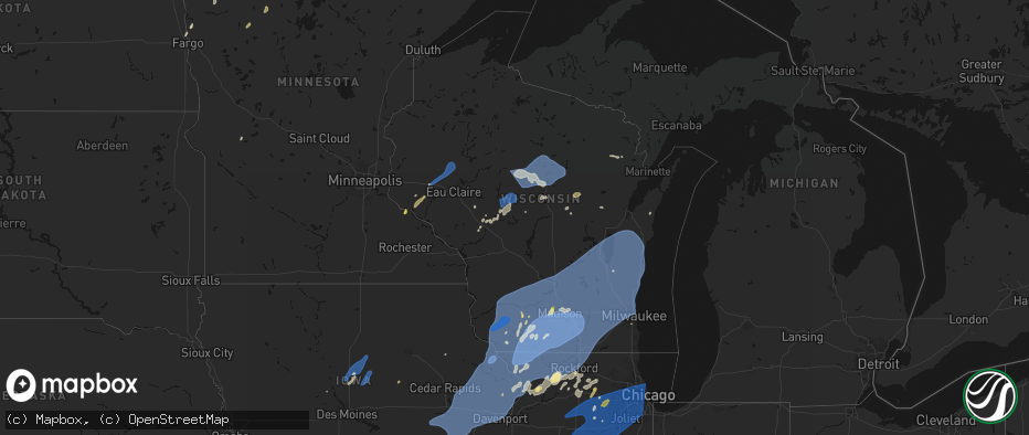
Hail Map in Wisconsin on June 10, 2026
The weather event in Wisconsin on June 10, 2026 includes Wind, Hail, and Tornado maps. 18 states and 2,073 cities were impacted and suffered possible damage. The total estimated number of properties impacted is 22,671.
Wind
Hail
Tornado
22,671
Estimated number of impacted properties by a 1.00" hail or larger0
Estimated number of impacted properties by a 1.75" hail or larger0
Estimated number of impacted properties by a 2.50" hail or largerStorm reports in Wisconsin
Wisconsin
| Date | Description |
|---|---|
| 06/10/20266:35 PM CDT | Report of large tree branches down in onalaska... Estimated 2-3 inches in diameter. |
| 06/10/20266:28 PM CDT | Report from mping: quarter |
| 06/10/20266:20 PM CDT | A local report indicates 1.50 inch wind near 1 ESE New Amsterdam |
| 06/10/20266:17 PM CDT | Time estimated from radar. |
| 06/10/20266:14 PM CDT | Photo of multiple large trees down in homeowners yard. Time estimated from radar. |
| 06/10/20266:03 PM CDT | Tree down. |
| 06/10/20265:55 PM CDT | Image of an outdoor animal cage damaged via social media. Time estimated from radar. |
| 06/10/20265:42 PM CDT | Several images of tree and building damage via social media. Time estimated from radar. |
| 06/10/20265:40 PM CDT | Pole barn damaged and a couple trees downed. |
| 06/10/20265:29 PM CDT | Metal pole barn destroyed with debris scattered to the n/ne. Picture from social media. Time est from radar. |
| 06/10/20264:50 PM CDT | Trees across the roads between neopit and langlade county line. Time estimated by radar. |
| 06/10/20264:33 PM CDT | In bowler trees and power line down. |
| 06/10/20264:04 PM CDT | Trees down. |
| 06/10/20263:50 PM CDT | Large trees down at john muir middle school. Time estimated from radar. |
| 06/10/20263:41 PM CDT | Kenosha airport. |
| 06/10/20263:40 PM CDT | Multiple trees and power lines are down. |
| 06/10/20263:40 PM CDT | Many reports of downed trees and power lines with focus in northern half of the county. Time est from radar. |
| 06/10/20263:40 PM CDT | Trees and power lines down at 10/114. |
| 06/10/20263:30 PM CDT | Large tree down. Branches fell on house. Unknown house damage. |
| 06/10/20263:20 PM CDT | Numerous trees and power lines down in the city. |
| 06/10/20263:17 PM CDT | Asos station kosh oshkosh airport. |
| 06/10/20263:14 PM CDT | Small tree snapped about half way up. Picture from social media. |
| 06/10/20263:10 PM CDT | Image of large tree uprooted via social media. |
| 06/10/20263:10 PM CDT | Several trees down in fond du lac and brandon. |
| 06/10/20263:09 PM CDT | Several large branches down. |
| 06/10/20263:00 PM CDT | Large tree down near intersection of main st and union st north of downtown. Picture from social media. Time est from radar. |
| 06/10/20263:00 PM CDT | Large branches down. Picture from social media. Time est from radar. |
| 06/10/20263:00 PM CDT | Tree on house. Time est from radar. |
| 06/10/20263:00 PM CDT | Damage to structures in downtown horicon. |
| 06/10/20263:00 PM CDT | Several structures damaged across dodge county. |
| 06/10/20263:00 PM CDT | Large branch down from oak tree and minor shingle damage from a newer roof. |
| 06/10/20262:50 PM CDT | Tree downed. Time of report is 355 pm cdt. Time tree fell estimated from radar. |
| 06/10/20262:50 PM CDT | Large tree trunk snapped. Picture from social media. Time estimated from radar. |
| 06/10/20262:49 PM CDT | Home wx station. |
| 06/10/20262:45 PM CDT | Home wx station. |
| 06/10/20262:41 PM CDT | Report of a tree that fell on a house in mauston... Estimated 2.5ft in diameter. Time estimated from radar. |
| 06/10/20262:40 PM CDT | Iconic blue barn destroyed. Multiple social media pictures. Time est from radar. |
| 06/10/20262:39 PM CDT | Trained spotter estimates 75 mph wind gusts. |
| 06/10/20262:35 PM CDT | Tree fell on power pole/light pole. |
| 06/10/20262:35 PM CDT | Trained spotter estimates 80 mph wind gusts. |
| 06/10/20262:34 PM CDT | Home wx station. |
| 06/10/20262:30 PM CDT | 2 foot diameter pine tree trunk snapped. Picture from social media. Time est from radar. |
| 06/10/20262:30 PM CDT | Report of a 8-10 inch downed tree. Time estimated from radar. |
| 06/10/20262:27 PM CDT | Tree limbs down. |
| 06/10/20262:26 PM CDT | Trained spotter estimates 85 mph wind gusts. |
| 06/10/20262:23 PM CDT | Tree blocking roadway. Time of report 448 pm cdt. Time trees fell estimated from radar. |
| 06/10/20262:22 PM CDT | Large branch down. Picture from social media. Time est from radar. |
| 06/10/20262:17 PM CDT | Large branches down. Picture from social media. Time est from radar. |
| 06/10/20262:15 PM CDT | Large branch down. Picture from social media. Time est from radar. |
| 06/10/20262:12 PM CDT | 85 mph wind gust estimated from home instrumentation. |
| 06/10/20262:10 PM CDT | Home wx station. |
| 06/10/20262:10 PM CDT | Home wx station. |
| 06/10/20262:10 PM CDT | Trained spotter estimates 80 mph wind gusts. |
| 06/10/20262:08 PM CDT | Many large branches down. Pictures from social media. |
| 06/10/20262:05 PM CDT | Approx 6 inch tree branch down. |
| 06/10/20262:00 PM CDT | Large tree uprooted and on power lines. Picture from social media. Time est from radar. |
| 06/10/20262:00 PM CDT | Delayed report... Time estimated from radar. Tree down on hwy g north of augusta. |
| 06/10/20262:00 PM CDT | Home wx station. |
| 06/10/20261:55 PM CDT | Picture of a large branch split off mature tree. |
| 06/10/20261:52 PM CDT | 70mph wind gust measured with handheld anemometer - kestrel 2500. |
| 06/10/20261:47 PM CDT | Many large branches down across town. Pictures from social media. Time est from radar. |
| 06/10/20261:46 PM CDT | Roof off of an apartment building. |
| 06/10/20261:44 PM CDT | Delayed report... Time estimated from radar. Tree down near fall creek. |
| 06/10/20261:40 PM CDT | Report of large tree branch down on home... Time estimated from radar. |
| 06/10/20261:40 PM CDT | Brigham wisconet station. |
| 06/10/20261:35 PM CDT | A local report indicates 74 MPH wind near 3 W Livingston |
| 06/10/20261:35 PM CDT | Report of a couple trees down in the town of seymour. |
| 06/10/20261:31 PM CDT | A local report indicates 85 MPH wind near Livingston |
| 06/10/20261:28 PM CDT | Trained spotter measures 88 mph gust on home weather station. |
| 06/10/20261:27 PM CDT | A local report indicates 65 MPH wind near Stitzer |
| 06/10/20261:26 PM CDT | Corrects time of previous tstm wnd dmg report from 3 sw hollandale. Metal pole barn destroyed with debris scattered to the n/ne. Picture from social media. Time est fro |
| 06/10/20261:25 PM CDT | Tree down on a structure. Time est from radar. |
| 06/10/20261:21 PM CDT | A local report indicates 68 MPH wind near 4 SSE Platteville |
| 06/10/20261:19 PM CDT | Also reported some trees down and signs blown around. |
| 06/10/20261:17 PM CDT | A local report indicates 60 MPH wind near 4 SSE Platteville |
| 06/10/20261:15 PM CDT | Delayed report relayed by law enforcement. Large tree branch down on the side of a house. |
| 06/10/20261:10 PM CDT | A local report indicates 61 MPH wind near Potosi |
| 06/10/202612:56 PM CDT | Image of large tree uprooted via social media. Time estimated from radar. |
| 06/10/202612:56 PM CDT | Tree down on a powerline in menomonie. Relayed from dispatch. |
| 06/10/202612:50 PM CDT | Delayed report. Downed trees caused some roof damage to house. |
| 06/10/202612:49 PM CDT | A local report indicates 60 MPH wind near Kieler |
| 06/10/202612:47 PM CDT | Several reports of trees and powerlines down between downsville and menomonie. |
| 06/10/202612:35 PM CDT | A couple large trees downed east of plum city. |
| 06/10/202612:30 PM CDT | Delayed report: farm with roof damage and two residences with damage to sheds/house roofs. Time estimated from em. Photos via nws chat. |
| 06/10/202612:20 PM CDT | Delayed report relayed via state official. Report of one farm with roof/overhead door damage and two residences with roof damage and blown over trees in pierce county. |
| 06/10/20267:45 AM CDT | Tree limbs down. Time estimated from radar. |
| 06/10/20267:06 AM CDT | Tree down along highway 97. |
| 06/10/20267:04 AM CDT | Oak tree snapped. |
| 06/09/20267:33 PM CDT | Report of a roof blown off a building at volk field. |
| 06/09/20267:33 PM CDT | A local report indicates 59 MPH wind near 2 NE Camp Douglas |
| 06/09/20267:30 PM CDT | Delayed report: spotter bar-d67. |
All States Impacted by Hail Map on June 10, 2026
Cities Impacted by Hail Map on June 10, 2026
- Granton, WI
- Chili, WI
- Dorchester, WI
- Athens, WI
- Stetsonville, WI
- Edgar, WI
- Stratford, WI
- Marshfield, WI
- Neillsville, WI
- Marathon, WI
- Mosinee, WI
- Black River Falls, WI
- Medford, WI
- Land O'Lakes, WI
- Merrillan, WI
- Watersmeet, MI
- Wausau, WI
- Auburndale, WI
- Gallatin, MO
- Jameson, MO
- Pittsville, WI
- Arpin, WI
- Gower, MO
- Greenwood, WI
- Loyal, WI
- Spencer, WI
- Curtiss, WI
- Colby, WI
- Unity, WI
- Owen, WI
- Abbotsford, WI
- Schofield, WI
- Rothschild, WI
- Merrill, WI
- Brokaw, WI
- Aniwa, WI
- Ringle, WI
- Irma, WI
- Gleason, WI
- Antigo, WI
- Tigerton, WI
- Junction City, WI
- Stevens Point, WI
- Amherst Junction, WI
- Chula, MO
- Leopolis, WI
- Caroline, WI
- Marion, WI
- Iola, WI
- Hamilton, MO
- Gresham, WI
- Shawano, WI
- Ogdensburg, WI
- Manawa, WI
- Clintonville, WI
- Wheeling, MO
- Meadville, MO
- Tilleda, WI
- Crivitz, WI
- Embarrass, WI
- Shiocton, WI
- Bonduel, WI
- Pulaski, WI
- Green Castle, MO
- Black Creek, WI
- Seymour, WI
- Woodward, IA
- Ogden, IA
- Boone, IA
- Waupaca, WI
- Amherst, WI
- Nekoosa, WI
- Nevada, IA
- Ames, IA
- Nelsonville, WI
- Bancroft, WI
- Story City, IA
- Gilbert, IA
- Roland, IA
- Ellsworth, IA
- Radcliffe, IA
- McCallsburg, IA
- Hubbard, IA
- Garden City, IA
- Zearing, IA
- Colo, IA
- State Center, IA
- Saint Anthony, IA
- Clemons, IA
- Union, IA
- New Providence, IA
- Scandinavia, WI
- Eldora, IA
- Iowa Falls, IA
- Montour, IA
- Toledo, IA
- Tama, IA
- Mount Pleasant, IA
- Wayland, IA
- Almond, WI
- Ainsworth, IA
- Kewaunee, WI
- Fairfield, IA
- Lockridge, IA
- Brighton, IA
- Crawfordsville, IA
- Winfield, IA
- Olds, IA
- Columbus Junction, IA
- Columbus City, IA
- Conesville, IA
- Algoma, WI
- Clutier, IA
- Craig, MO
- Letts, IA
- Muscatine, IA
- Wapello, IA
- Fruitland, IA
- Fairfax, MO
- Washington, IA
- Riverside, IA
- Kalona, IA
- Wellman, IA
- Lone Tree, IA
- Keota, IA
- Nichols, IA
- Hills, IA
- Iowa City, IA
- West Liberty, IA
- West Branch, IA
- Solon, IA
- Atalissa, IA
- Illinois City, IL
- Moscow, IA
- Tipton, IA
- Wilton, IA
- Cowgill, MO
- Kingston, MO
- Polo, MO
- Cameron, MO
- Kidder, MO
- Breckenridge, MO
- Braymer, MO
- Goodhue, MN
- Lake City, MN
- Red Wing, MN
- Cedar Rapids, IA
- Durant, IA
- Montpelier, IA
- Blue Grass, IA
- Lisbon, IA
- Stockton, IA
- Taylor Ridge, IL
- Walcott, IA
- Buffalo, IA
- Rock Island, IL
- Davenport, IA
- Mount Vernon, IA
- Bennett, IA
- Milan, IL
- Moline, IL
- New Liberty, IA
- Mechanicsville, IA
- Dixon, IA
- Donahue, IA
- Calamus, IA
- Dunkerton, IA
- Jesup, IA
- Waterloo, IA
- Bettendorf, IA
- Clarence, IA
- Stanwood, IA
- Hampton, IL
- Port Byron, IL
- East Moline, IL
- Long Grove, IA
- Rapids City, IL
- Eldridge, IA
- Lowden, IA
- Pleasant Valley, IA
- Wheatland, IA
- Le Claire, IA
- Lost Nation, IA
- Morley, IA
- Anamosa, IA
- Cascade, IA
- Wyoming, IA
- Oxford Junction, IA
- Onslow, IA
- Baldwin, IA
- Olin, IA
- Grand Mound, IA
- Princeton, IA
- Center Junction, IA
- De Witt, IA
- Monmouth, IA
- Monticello, IA
- Delmar, IA
- Maquoketa, IA
- Bernard, IA
- Camanche, IA
- Welton, IA
- Charlotte, IA
- McCausland, IA
- Cordova, IL
- Zwingle, IA
- Elmwood, WI
- Maiden Rock, WI
- Stockholm, WI
- Plum City, WI
- Manchester, IA
- Masonville, IA
- Winthrop, IA
- Appomattox, VA
- La Motte, IA
- Goose Lake, IA
- Fulton, IL
- Clinton, IA
- Andrew, IA
- Bryant, IA
- Low Moor, IA
- Albany, IL
- Spragueville, IA
- Preston, IA
- Bellevue, IA
- Peosta, IA
- Dubuque, IA
- Miles, IA
- East Dubuque, IL
- Arkansaw, WI
- Dundee, IA
- Menomonie, WI
- Eau Galle, WI
- Hazel Green, WI
- Cuba City, WI
- Sabula, IA
- Galena, IL
- Teeds Grove, IA
- Savanna, IL
- Hanover, IL
- Kieler, WI
- Thomson, IL
- Morrison, IL
- Dickeyville, WI
- Platteville, WI
- Potosi, WI
- Elizabeth, IL
- Shullsburg, WI
- Scales Mound, IL
- Benton, WI
- Fargo, ND
- Moorhead, MN
- Mount Carroll, IL
- Stockton, IL
- Lanark, IL
- Belmont, WI
- Apple River, IL
- Pearl City, IL
- Mineral Point, WI
- Darlington, WI
- Georgetown, MN
- Chadwick, IL
- Sterling, IL
- Gratiot, WI
- Clarence, MO
- Colfax, WI
- Bloomer, WI
- New Auburn, WI
- Kent, IL
- Warren, IL
- Rewey, WI
- Lena, IL
- Nora, IL
- Shannon, IL
- Winslow, IL
- Dodgeville, WI
- Blanchardville, WI
- Freeport, IL
- Argyle, WI
- Hollandale, WI
- South Wayne, WI
- Baileyville, IL
- Browntown, WI
- Forreston, IL
- McConnell, IL
- Lancaster, WI
- Newfolden, MN
- Middle River, MN
- Milledgeville, IL
- Mount Hope, WI
- Cairo, MO
- Livingston, WI
- Stitzer, WI
- Fennimore, WI
- Linden, WI
- Montfort, WI
- Cobb, WI
- Highland, WI
- Muscoda, WI
- Woodford, WI
- Monroe, WI
- Orangeville, IL
- Macomb, IL
- Sherrill, IA
- Durango, IA
- Strathcona, MN
- Wannaska, MN
- Badger, MN
- Roseau, MN
- Mount Morris, IL
- Leaf River, IL
- Polo, IL
- German Valley, IL
- Thief River Falls, MN
- Osseo, WI
- Paris, MO
- Shelbina, MO
- Marietta, IL
- Blue River, WI
- Boscobel, WI
- Arena, WI
- Ridgeway, WI
- Avoca, WI
- Dakota, IL
- Lone Rock, WI
- Cedarville, IL
- Barneveld, WI
- Spring Green, WI
- Ridott, IL
- Rockford, IL
- Winnebago, IL
- Pecatonica, IL
- Rock City, IL
- Byron, IL
- North Freedom, WI
- Loganville, WI
- Hillpoint, WI
- Richland Center, WI
- Monticello, WI
- Plain, WI
- Belleville, WI
- Mount Horeb, WI
- Black Earth, WI
- New Glarus, WI
- Blue Mounds, WI
- Durand, IL
- Prairie Du Sac, WI
- Mazomanie, WI
- Brodhead, WI
- Davis, IL
- Sauk City, WI
- Juda, WI
- Gotham, WI
- Cazenovia, WI
- Gary, MN
- Fairchild, WI
- Fertile, MN
- Oregon, IL
- Red Lake Falls, MN
- Alma Center, WI
- Madison, WI
- Verona, WI
- Augusta, WI
- Middleton, WI
- Evansville, WI
- Cross Plains, WI
- Oregon, WI
- Albany, WI
- Orfordville, WI
- Lodi, WI
- Merrimac, WI
- Waunakee, WI
- Dane, WI
- Brooklyn, WI
- Baraboo, WI
- Deforest, WI
- Beloit, WI
- Footville, WI
- Rockton, IL
- Janesville, WI
- Shirland, IL
- South Beloit, IL
- Stoughton, WI
- Mcfarland, WI
- Goodridge, MN
- Melrose, WI
- Hillsboro, WI
- Amboy, IL
- Franklin Grove, IL
- Dixon, IL
- Eldena, IL
- Lenox, IA
- Sharpsburg, IA
- Chana, IL
- Cottage Grove, WI
- Humbird, WI
- Stillman Valley, IL
- Deerfield, WI
- Milton, WI
- Edgerton, WI
- Cambridge, WI
- Bedford, IA
- Rochelle, IL
- Gatzke, MN
- Grygla, MN
- South Boston, VA
- Clearfield, IA
- Sun Prairie, WI
- Monroe Center, IL
- Davis Junction, IL
- Halifax, VA
- Princeville, IL
- Fort Atkinson, WI
- Lake Mills, WI
- Diagonal, IA
- New Hampton, MO
- Bethany, MO
- Waterman, IL
- Steward, IL
- Mcintosh, MN
- Trail, MN
- Fosston, MN
- Esmond, IL
- Malta, IL
- Clare, IL
- Jamesport, MO
- Lindenwood, IL
- Cherry Valley, IL
- Kirkland, IL
- Gully, MN
- Afton, WI
- Windsor, WI
- Marshall, WI
- Waterloo, WI
- Loves Park, IL
- Jefferson, WI
- Clinton, WI
- Whitewater, WI
- Roscoe, IL
- Watertown, WI
- Machesney Park, IL
- Johnson Creek, WI
- Caledonia, IL
- Sharon, WI
- Helenville, WI
- Avalon, WI
- Darien, WI
- Delavan, WI
- Poplar Grove, IL
- Capron, IL
- Belvidere, IL
- Salol, MN
- Dekalb, IL
- Tingley, IA
- Shannon City, IA
- Nelson, VA
- Buffalo Junction, VA
- Murray, IA
- Afton, IA
- Thayer, IA
- Ellston, IA
- Shabbona, IL
- Earlville, IL
- Genoa, IL
- Sycamore, IL
- Kingston, IL
- Cortland, IL
- Maple Park, IL
- Mount Ayr, IA
- Virgilina, VA
- Savannah, MO
- Saint Joseph, MO
- Grant City, MO
- Lee, IL
- Yates City, IL
- Elmwood, IL
- Canton, IL
- Farmington, IL
- Morton, IL
- Mapleton, IL
- East Peoria, IL
- Glasford, IL
- Groveland, IL
- Hanna City, IL
- Creve Coeur, IL
- Trivoli, IL
- Pekin, IL
- Peoria, IL
- Peoria Heights, IL
- Washington, IL
- Brimfield, IL
- Metamora, IL
- Edwards, IL
- Goodfield, IL
- Deer Creek, IL
- Lengby, MN
- Danvers, IL
- Bloomington, IL
- Big Rock, IL
- Hinckley, IL
- Elburn, IL
- Sugar Grove, IL
- Balmorhea, TX
- Naytahwaush, MN
- Mahnomen, MN
- Helena, MO
- Osceola, IA
- Grand River, IA
- Lamoni, IA
- Van Wert, IA
- Winchester, IL
- Murrayville, IL
- Plano, IL
- Weldon, IA
- Hatfield, MO
- Kellerton, IA
- Bolckow, MO
- Rea, MO
- Guilford, MO
- Union Star, MO
- Cosby, MO
- Ridgeway, MO
- Somonauk, IL
- Sandwich, IL
- Hampshire, IL
- Dunlap, IL
- Mossville, IL
- Edelstein, IL
- Chillicothe, IL
- Speer, IL
- Sparland, IL
- Lowpoint, IL
- Eureka, IL
- Granville, IL
- Lacon, IL
- Hennepin, IL
- Magnolia, IL
- Putnam, IL
- Henry, IL
- La Rose, IL
- McNabb, IL
- Washburn, IL
- Roanoke, IL
- Varna, IL
- Toluca, IL
- Rutland, IL
- Secor, IL
- Long Point, IL
- Tonica, IL
- Congerville, IL
- Wenona, IL
- Ransom, IL
- El Paso, IL
- Dana, IL
- Ancona, IL
- Lostant, IL
- Grand Ridge, IL
- Minonk, IL
- Benson, IL
- Streator, IL
- Leonore, IL
- Cornell, IL
- Flanagan, IL
- Seneca, IL
- Blackstone, IL
- Ottawa, IL
- Oglesby, IL
- Gridley, IL
- Pontiac, IL
- Mendota, IL
- La Moille, IL
- Paw Paw, IL
- Compton, IL
- Sublette, IL
- Moberly, MO
- King City, MO
- Stanberry, MO
- Bristol, IL
- Yorkville, IL
- Aurora, IL
- Montgomery, IL
- Cainsville, MO
- Chariton, IA
- Lucas, IA
- Woodburn, IA
- Madison, MO
- Clark, MO
- Newark, IL
- Amity, MO
- Mooseheart, IL
- Batavia, IL
- Geneva, IL
- North Aurora, IL
- Bagley, MN
- Princeton, MO
- Jacksonville, IL
- Elgin, IL
- Fort Davis, TX
- Eden, WI
- Clarksdale, MO
- Sheridan, IL
- Leland, IL
- Utica, IL
- Peru, IL
- Cedar Point, IL
- Wedron, IL
- Serena, IL
- Marseilles, IL
- Maysville, MO
- Waubun, MN
- Ponsford, MN
- Decatur, IA
- Leon, IA
- Holliday, MO
- Oak Creek, WI
- McLean, IL
- Waynesville, IL
- Denver, MO
- Warrenville, IL
- Saint Charles, IL
- West Chicago, IL
- Oswego, IL
- Winfield, IL
- Plainfield, IL
- Naperville, IL
- Carol Stream, IL
- Gardner, IL
- Dwight, IL
- Derby, IA
- Odell, IL
- Mequon, WI
- Milwaukee, WI
- Plainfield, WI
- Darlington, MO
- Albany, MO
- Gentry, MO
- Graymont, IL
- Coal City, IL
- Elwood, IL
- Channahon, IL
- Millbrook, IL
- Minooka, IL
- Mazon, IL
- Kinsman, IL
- Wilmington, IL
- Braidwood, IL
- Braceville, IL
- Millington, IL
- Morris, IL
- Verona, IL
- Lombard, IL
- Chicago, IL
- Lisle, IL
- Homer Glen, IL
- Lincolnwood, IL
- Des Plaines, IL
- Stone Park, IL
- Evanston, IL
- Glendale Heights, IL
- Wheaton, IL
- Western Springs, IL
- Park Ridge, IL
- Oak Park, IL
- Broadview, IL
- Hines, IL
- Palos Park, IL
- Maywood, IL
- Willow Springs, IL
- Franklin Park, IL
- Lyons, IL
- Bensenville, IL
- Lockport, IL
- Justice, IL
- Brookfield, IL
- Romeoville, IL
- River Forest, IL
- La Grange Park, IL
- Clarendon Hills, IL
- Orland Park, IL
- Westmont, IL
- Berwyn, IL
- Bridgeview, IL
- River Grove, IL
- Skokie, IL
- Hillside, IL
- Manhattan, IL
- Westchester, IL
- Addison, IL
- Woodridge, IL
- Villa Park, IL
- Elmwood Park, IL
- Harwood Heights, IL
- Shorewood, IL
- Summit Argo, IL
- Hinsdale, IL
- Forest Park, IL
- Darien, IL
- Bloomingdale, IL
- Bolingbrook, IL
- Riverside, IL
- Cicero, IL
- Oak Brook, IL
- Glen Ellyn, IL
- Joliet, IL
- Wood Dale, IL
- New Lenox, IL
- Schiller Park, IL
- Niles, IL
- Bellwood, IL
- Melrose Park, IL
- Crest Hill, IL
- Willowbrook, IL
- Elmhurst, IL
- Lemont, IL
- Berkeley, IL
- Downers Grove, IL
- La Grange, IL
- Hickory Hills, IL
- Mokena, IL
- Itasca, IL
- Hanover Park, IL
- Russell, IA
- Humeston, IA
- Martinsville, MO
- Pattonsburg, MO
- Weatherby, MO
- Emington, IL
- Cabery, IL
- Bussey, IA
- Gilman City, MO
- Garden Grove, IA
- Monroe City, MO
- Stoutsville, MO
- Omro, WI
- Markesan, WI
- Eldorado, WI
- Clyman, WI
- Friesland, WI
- Rosendale, WI
- Morrisonville, WI
- Columbus, WI
- Waupun, WI
- Lowell, WI
- Oshkosh, WI
- Brandon, WI
- Pickett, WI
- Rio, WI
- Fox Lake, WI
- Arlington, WI
- Horicon, WI
- Juneau, WI
- Fairwater, WI
- Ripon, WI
- Beaver Dam, WI
- Randolph, WI
- Fall River, WI
- Burnett, WI
- Doylestown, WI
- Poynette, WI
- Reeseville, WI
- Cambria, WI
- Blue Island, IL
- Evergreen Park, IL
- Palos Heights, IL
- Oak Lawn, IL
- Frankfort, IL
- Tinley Park, IL
- Chicago Ridge, IL
- Robbins, IL
- Hometown, IL
- Oak Forest, IL
- Crestwood, IL
- Midlothian, IL
- Burbank, IL
- Country Club Hills, IL
- Markham, IL
- Palos Hills, IL
- Worth, IL
- Alsip, IL
- Kingston, WI
- Montello, WI
- Dalton, WI
- Berlin, WI
- Pardeeville, WI
- Marquette, WI
- Green Lake, WI
- Portage, WI
- Princeton, WI
- Wyocena, WI
- Lovilia, IA
- Rock Springs, WI
- Wisconsin Dells, WI
- Reedsburg, WI
- Malone, WI
- Fond Du Lac, WI
- Oakfield, WI
- Hustisford, WI
- Dousman, WI
- Elkhart Lake, WI
- New Holstein, WI
- Lebanon, WI
- Theresa, WI
- West Bend, WI
- Lomira, WI
- Saint Cloud, WI
- Hilbert, WI
- Palmyra, WI
- Chilton, WI
- Rubicon, WI
- Ashippun, WI
- Neosho, WI
- Kiel, WI
- Allenton, WI
- Campbellsport, WI
- Kewaskum, WI
- Reedsville, WI
- Hartford, WI
- Potter, WI
- Van Dyne, WI
- Elkhorn, WI
- Iron Ridge, WI
- Sullivan, WI
- Stockbridge, WI
- Glenbeulah, WI
- Brownsville, WI
- Brillion, WI
- Ixonia, WI
- Mayville, WI
- Oconomowoc, WI
- Collins, WI
- Mount Calvary, WI
- Menasha, WI
- Forest Junction, WI
- Sherwood, WI
- Greenleaf, WI
- Neenah, WI
- Melrose, IA
- Corydon, IA
- Pecos, TX
- Hamilton, IA
- Shevlin, MN
- Eagleville, MO
- Hancock, MN
- Cyrus, MN
- Starbuck, MN
- Solway, MN
- Unionville, MO
- Lucerne, MO
- Saint Nazianz, WI
- Delafield, WI
- Eagle, WI
- Cascade, WI
- Hartland, WI
- Elm Grove, WI
- Saukville, WI
- Sheboygan Falls, WI
- Wales, WI
- Burlington, WI
- Menomonee Falls, WI
- Sussex, WI
- Lannon, WI
- Grafton, WI
- Muskego, WI
- Cedarburg, WI
- Slinger, WI
- Colgate, WI
- Brookfield, WI
- Jackson, WI
- Pewaukee, WI
- New Berlin, WI
- Random Lake, WI
- Butler, WI
- Adell, WI
- Belgium, WI
- Mukwonago, WI
- Valders, WI
- Okauchee, WI
- North Prairie, WI
- Waldo, WI
- East Troy, WI
- Nashotah, WI
- Big Bend, WI
- Walworth, WI
- Germantown, WI
- Richfield, WI
- Plymouth, WI
- Hubertus, WI
- Fredonia, WI
- Waukesha, WI
- Coffey, MO
- Altamont, MO
- McFall, MO
- Waterford, WI
- Oostburg, WI
- Cleveland, WI
- Port Washington, WI
- Cedar Grove, WI
- Hales Corners, WI
- Kohler, WI
- Newton, WI
- Whitelaw, WI
- Sheboygan, WI
- Manitowoc, WI
- Sturgeon Lake, MN
- Moose Lake, MN
- Clinton, IL
- Pella, IA
- Bemidji, MN
- Boyceville, WI
- Pollock, MO
- Powersville, MO
- Wisconsin Rapids, WI
- Rudolph, WI
- Custer, WI
- Rosholt, WI
- Wittenberg, WI
- South English, IA
- Webster, IA
- Dewitt, IL
- Menahga, MN
- Durand, WI
- Byron, MN
- Davis City, IA
- Blythedale, MO
- Courtenay, ND
- Buchanan, ND
- Millerton, IA
- Harper, IA
- Glenwood, MN
- Lowry, MN
- Rochester, MN
- Lineville, IA
- Sebeka, MN
- Kelliher, MN
- Hines, MN
- Tenstrike, MN
- Waskish, MN
- Bluffton, MN
- Deer Creek, MN
- Wadena, MN
- Trenton, MO
- Winston, MO
- Pepin, WI
- Bowler, WI
- North English, IA
- Park Rapids, MN
- Van Horn, TX
- Albia, IA
- Illiopolis, IL
- New York Mills, MN
- New Sharon, IA
- Henning, MN
- Verndale, MN
- Blackduck, MN
- Villard, MN
- Floodwood, MN
- Montezuma, IA
- Eyota, MN
- Mystic, IA
- Ottumwa, IA
- Latham, IL
- Warrensburg, IL
- Niantic, IL
- Morrisonville, IL
- Harvel, IL
- Hedrick, IA
- Spickard, MO
- Butler, IL
- Litchfield, IL
- Birnamwood, WI
- Alexandria, MN
- Osakis, MN
- Sauk Centre, MN
- West Union, MN
- Grey Eagle, MN
- Long Prairie, MN
- Big Falls, MN
- Raymond, IL
- Moravia, IA
- Elgin, MN
- Richland, IA
- Ollie, IA
- Galt, MO
- Laredo, MO
- Packwood, IA
- Nokomis, IL
- Exline, IA
- Moulton, IA
- Burtrum, MN
- Posen, IL
- Thornton, IL
- Gary, IN
- Whiting, IN
- Dolton, IL
- Harvey, IL
- Lansing, IL
- Riverdale, IL
- Hammond, IN
- South Holland, IL
- Hazel Crest, IL
- Calumet City, IL
- East Chicago, IN
- Matteson, IL
- Homewood, IL
- Westville, IN
- Valparaiso, IN
- Wanatah, IN
- Union Mills, IN
- Swanville, MN
- La Porte, IN
- Hanna, IN
- Hamlet, IN
- Kingsford Heights, IN
- Atlanta, MO
- Petersburg, ND
- Humphreys, MO
- Guthrie Center, IA
- Pomeroy, OH
- Langsville, OH
- Rutland, OH
- Staples, MN
- Hibbing, MN
- Stewartville, MN
- Racine, MN
- Spring Valley, MN
- Casey, IA
- Meadowlands, MN
- Milan, MO
- Browning, MO
- Sodus, MI
- Coloma, MI
- Watervliet, MI
- Covert, MI
- Saint Joseph, MI
- Stevensville, MI
- Benton Harbor, MI
- Eau Claire, MI
- South Haven, MI
- Hartford, MI
- Grand Junction, MI
- Lawrence, MI
- Bangor, MI
- Fennville, MI
- Pullman, MI
- Douglas, MI
- Holland, MI
- Saugatuck, MI
- Hamilton, MI
- Macatawa, MI
- Northome, MN
- Forest Lake, MN
- Stacy, MN
- Wyoming, MN
- Bloomfield, IA
- Dearborn, MI
- Dearborn Heights, MI
- White Cloud, KS
- Westpoint, IN
- Menlo, IA
- Cedar, MN
- Bouton, IA
- Minburn, IA
- Alma, WI
- Oregon, MO
- Maitland, MO
- Graham, MO
- Stuart, IA
- Independence, WI
- Dallas Center, IA
- Winona, MN
- Green City, MO
- Chatfield, MN
- Wykoff, MN
- La Belle, MO
- Knox City, MO
- Barnard, MO
- Chisago City, MN
- Middleton, MI
- Larimore, ND
- Taylor, MI
- Mount Airy, NC
- Houston, MN
- Lafayette, IN
- Salina, KS
- Novelty, MO
- Edina, MO
- Udell, IA
- Mondovi, WI
- Detroit, MI
- Mound City, MO
- Monroeville, OH
- Norwalk, OH
- Dexter, IA
- Tolono, IL
- Philo, IL
- Plano, IA
- Fremont, IA
- Holyoke, MN
- Lindstrom, MN
- Shafer, MN
- Center City, MN
- Dresser, WI
- Taylors Falls, MN
- Saint Croix Falls, WI
- Downing, MO
- Leonardville, KS
- Green, KS
- Bena, MN
- Sidney, IL
- Fontanelle, IA
- Greenfield, IA
- Cincinnati, IA
- Adel, IA
- Winigan, MO
- Grimes, IA
- Adair, IA
- North Branch, MN
- Randolph, KS
- Ithaca, MI
- Centerville, IA
- Seymour, IA
- Hugo, MN
- Aitkin, MN
- Maryville, MO
- Skidmore, MO
- Harris, MN
- Bennington, KS
- New Cambria, KS
- Wellington, OH
- New London, OH
- Solomon, KS
- Longford, KS
- Clay Center, KS
- Carleton, MI
- Redfield, IA
- Osage, MN
- Centuria, WI
- Mercer, MO
- Lewistown, MO
- Allen Park, MI
- Inkster, MI
- Highland Park, MI
- Hamtramck, MI
- Trempealeau, WI
- Dakota, MN
- Galesville, WI
- Fountain, MN
- Earlham, IA
- Side Lake, MN
- New Boston, MO
- Purdin, MO
- Nevis, MN
- Lanesboro, MN
- Wakefield, KS
- Cook, MN
- Great Bend, KS
- Milltown, WI
- Luck, WI
- Williamstown, MO
- Kahoka, MO
- Angora, MN
- Granger, IA
- De Soto, IA
- Anita, IA
- Conception Junction, MO
- Effie, MN
- Novinger, MO
- Ellinwood, KS
- Holmen, WI
- Onalaska, WI
- Scandia, MN
- Marine On Saint Croix, MN
- Hiawatha, KS
- Melvindale, MI
- Worth, MO
- Rockwell, IA
- Redding, IA
- Deer River, MN
- Peterson, MN
- Conception, MO
- Kirksville, MO
- Tescott, KS
- Newark, MO
- Saint Patrick, MO
- Shelbyville, MO
- Bethel, MO
- Leonard, MO
- Rosendale, MO
- Roseville, MI
- Warren, MI
- Olsburg, KS
- Delphi, IN
- Palmer, IL
- Orr, MN
- Hixton, WI
- Bovey, MN
- Wadsworth, OH
- Abilene, KS
- Claflin, KS
- Bushton, KS
- Littlefork, MN
- Bigfork, MN
- Tamarack, MN
- La Crosse, WI
- Mcgregor, MN
- Balsam Lake, WI
- Amery, WI
- Fraser, MI
- Mindoro, WI
- Belding, MI
- Ettrick, WI
- West Des Moines, IA
- Onamia, MN
- Cohasset, MN
- Urbandale, IA
- Rulo, NE
- Collins, OH
- Fountain City, WI
- Hudson, KS
- Dayton, IA
- Waukee, IA
- Arcadia, WI
- Van Meter, IA
- Cumming, IA
- Allegan, MI
- Bloomingdale, MI
- Hopkins, MI
- Zeeland, MI
- North Judson, IN
- Knox, IN
- La Crosse, IN
- San Pierre, IN
- Wheatfield, IN
- Kouts, IN
- New Richmond, WI
- Webster City, IA
- Huron, OH
- Berlin Heights, OH
- Vermilion, OH
- Ravenwood, MO
- Kettle River, MN
- Doylestown, OH
- Barberton, OH
- Harris, MO
- Newtown, MO
- West Salem, WI
- Rushford, MN
- Plymouth, IN
- Grovertown, IN
- Walkerton, IN
- Des Moines, IA
- Norwalk, IA
- Talmage, KS
- Comstock, WI
- Turtle Lake, WI
- Lyons, KS
- Geneseo, KS
- Chase, KS
- Manhattan, KS
- McGrath, MN
- Finlayson, MN
- Willow River, MN
- Macon, MO
- Pilot Mound, IA
- Stratford, IA
- Hurdland, MO
- Wright, MN
- La Plata, MO
- Ewing, MO
- Brashear, MO
- Gibbs, MO
- Wakeman, OH
- Stanton, MI
- Edmore, MI
- Clear Lake, WI
- Warba, MN
- Askov, MN
- North Liberty, IN
- Lakeville, IN
- Dougherty, IA
- Sheffield, IA
- Bremen, IN
- Raymond, KS
- Almena, WI
- Cumberland, WI
- Sandstone, MN
- Stanhope, IA
- Jewell, IA
- Kamrar, IA
- Saint Johns, MI
- Enterprise, KS
- Marble Rock, IA
- Greene, IA
- Deer Park, WI
- Floyd, IA
- Rudd, IA
- Cromwell, MN
- Allerton, IA
- Forest City, MO
- Clyde, MO
- Parnell, MO
- Osage, IA
- Monticello, MO
- Marble, MN
- Calumet, MN
- Medina, OH
- Ashley, MI
- Lagrange, OH
- Rock Falls, IL
- Frankfort, KS
- Glenwood City, WI
- Barron, WI
- Little River, KS
- Sterling, KS
- Alden, KS
- Brookville, KS
- Canton, MO
- Rutledge, MO
- Kerrick, MN
- Elyria, OH
- Saint George, KS
- Chapman, KS
- Amherst, OH
- Bruno, MN
- Harmon, IL
- Ellsworth, KS
- Tomah, WI
- Blairsburg, IA
- Star Prairie, WI
- Clayton, WI
- Prairie Farm, WI
- Centralia, KS
- Vermillion, KS
- Akron, OH
- Sheridan, MO
- Nashwauk, MN
- Newton, IA
- Colfax, IA
- Prairie City, IA
- Williams, IA
- Litchfield, OH
- Grafton, OH
- Riceville, IA
- Pengilly, MN
- Caledonia, MN
- Westmoreland, KS
- Wamego, KS
- Wyaconda, MO
- Orient, IA
- Oberlin, OH
- Marcell, MN
- Kipton, OH
- Jacobson, MN
- Orchard, IA
- Rice Lake, WI
- Cameron, WI
- Windom, KS
- Macksburg, IA
- Pleasantville, IA
- Swan, IA
- Alden, IA
- Lorain, OH
- Seneca, KS
- Woodbine, KS
- Camp Douglas, WI
- Fillmore, MO
- Munger, MI
- Bay City, MI
- Saginaw, MI
- Lorimor, IA
- Winterset, IA
- Greenbush, MN
- New Market, IA
- Sheffield Lake, OH
- Morrill, KS
- Belvue, KS
- Junction City, KS
- Gypsum, KS
- Paxico, KS
- Carlton, MN
- Amazonia, MO
- Greentop, MO
- Reese, MI
- Fairgrove, MI
- Uniontown, OH
- Booneville, IA
- Sabetha, KS
- Milford, KS
- Clarksville, IA
- Hutchinson, KS
- Inman, KS
- Herington, KS
- Hope, KS
- Saint Charles, MN
- Queen City, MO
- Baring, MO
- Cleveland, OH
- Dover, MN
- Frazee, MN
- North Canton, OH
- Plainfield, IA
- Waverly, IA
- Linden, MI
- South Elgin, IL
- Worthington, MO
- Ackley, IA
- Altura, MN
- White City, KS
- New Lisbon, WI
- Necedah, WI
- Aplington, IA
- Dumont, IA
- Kesley, IA
- Arbela, MO
- Memphis, MO
- Warsaw, IL
- Mcpherson, KS
- Blockton, IA
- Allison, IA
- Fenton, MI
- Luray, MO
- Eastlake, OH
- Wickliffe, OH
- Euclid, OH
- Willoughby, OH
- Alma, KS
- Sutter, IL
- Ottertail, MN
- Plover, WI
- Silvis, IL
- Carbon Cliff, IL
- Colona, IL
- Erie, IL
- Chardon, OH
- Mentor, OH
- Hillsdale, IL
- Fenton, IL
- Huntsburg, OH
- Montville, OH
- Painesville, OH
- Windsor, OH
- Geneseo, IL
- Madison, OH
- Thompson, OH
- Prophetstown, IL
- Hooppole, IL
- Topeka, KS
- Maple Hill, KS
- Rome, OH
- Rock Creek, OH
- Geneva, OH
- Atkinson, IL
- Annawan, IL
- Mineral, IL
- Tampico, IL
- Sheffield, IL
- New Bedford, IL
- Walnut, IL
- Princeton, IL
- Manlius, IL
- Wyanet, IL
- Ohio, IL
- Hinckley, OH
- Gorin, MO
- Riley, KS
- Fort Riley, KS
- Orwell, OH
- Ferryville, WI
- Oelwein, IA
- Fairbank, IA
- Sumner, IA
- Westgate, IA
- Readlyn, IA
- Oran, IA
- Austinburg, OH
- Benton, IA
- Wayland, MO
- Viroqua, WI
- Alexandria, MO
- Tampa, KS
- Ramona, KS
- Eskridge, KS
- Jal, NM
- Conneaut, OH
- Ashtabula, OH
- North Kingsville, OH
- Richfield, OH
- Wilsey, KS
- Jefferson, OH
- Ipava, IL
- Lost Springs, KS
- Burdick, KS
- Maynard, IA
- Blair, WI
- Whitehall, WI
- Basco, IL
- Carthage, IL
- Soldiers Grove, WI
- Council Grove, KS
- Good Hope, IL
- Blandinsville, IL
- Sciota, IL
- Plymouth, IL
- West Springfield, PA
- East Springfield, PA
- Kingsville, OH
- Burlington Junction, MO
- Pickering, MO
- Cornell, WI
- Lewistown, IL
- Sutton, WV
- Lincolnville, KS
- Hopkins, MO
- Avon, IL
- Bushnell, IL
- Bardolph, IL
- Adair, IL
- Prairie City, IL
- Table Grove, IL
- Smithfield, IL
- Stanley, WI
- Thorp, WI
- Tennessee, IL
- Colchester, IL
- Strong City, KS
- Cuba, IL
- Prairie Du Chien, WI
- La Crescent, MN
- La Grange, MO
- Jamestown, PA
- Hartstown, PA
- Buhler, KS
- Cooperstown, ND
- Hannaford, ND
- Emporia, KS
- Conneaut Lake, PA
- Atlantic, PA
- Havana, IL
- Lisbon, OH
- Lublin, WI
- Cottonwood Falls, KS
- Topeka, IL
- Woodman, WI
- Liverpool, IL
- Linneus, MO
- Erie, PA
- Harborcreek, PA
- North East, PA
- Cochranton, PA
- Nickerson, KS
- South Hutchinson, KS
- Livonia, MO
- Ripley, NY
- Titusville, PA
- Easton, IL
- Bath, IL
- Glenwood, MO
- Rochester, PA
- New Brighton, PA
- Ethel, MO
- Elmer, MO
- Brookfield, MO
- Westfield, NY
- Zelienople, PA
- Evans City, PA
- Cranberry Township, PA
- Burrton, KS
- Moundridge, KS
- Kilbourne, IL
- Bucklin, MO
- New Cambria, MO
- Callao, MO
- San Jose, IL
- New Holland, IL
- Halstead, KS
- Butler, PA
- Mason City, IL
- Williamsville, IL
- Middletown, IL
- Lincoln, IL
- Mount Pulaski, IL
- Greenview, IL
- Beason, IL
- Sherman, IL
- Riverton, IL
- Cantrall, IL
- Athens, IL
- Elkhart, IL
- Petersburg, IL
- Buffalo, IL
- Springfield, IL
- Hesston, KS
- Newton, KS
- Sedgwick, KS
- Stanford, IL
- Templeton, PA
- North Newton, KS
- Atlanta, IL
- Kittanning, PA
- New Bethlehem, PA
- Dawson, IL
- Mechanicsburg, IL
- Mount Auburn, IL
- Decatur, IL
- Rochester, IL
- Pleasant Plains, IL
- Chestnut, IL
- Stonington, IL
- Macon, IL
- Harristown, IL
- Forsyth, IL
- Boody, IL
- Moweaqua, IL
- Maroa, IL
- Argenta, IL
- Blue Mound, IL
- Kenney, IL
- Oreana, IL
- Edinburg, IL
- Cisco, IL
- Taylorville, IL
- Hunnewell, MO
- Emden, MO
- Dayton, PA
- Weldon, IL
- Lane, IL
- Monticello, IL
- De Land, IL
- Mt Zion, IL
- Bondville, IL
- Cerro Gordo, IL
- Pesotum, IL
- Gays, IL
- La Place, IL
- Villa Grove, IL
- Ivesdale, IL
- Mansfield, IL
- Sadorus, IL
- Dalton City, IL
- Arcola, IL
- Sullivan, IL
- Milmine, IL
- Tuscola, IL
- Bement, IL
- Champaign, IL
- Saint Joseph, IL
- Atwood, IL
- Urbana, IL
- Hammond, IL
- Savoy, IL
- Windsor, IL
- Lovington, IL
- Arthur, IL
- Humboldt, IL
- White Heath, IL
- Bethany, IL
- Mattoon, IL
- Seymour, IL
- Findlay, IL
- Palmyra, MO
- Hannibal, MO
- Farmersville, IL
- Hull, IL
- New London, MO
- West Lafayette, IN
- Maywood, NE
- Moorefield, NE
- Curtis, NE
- Eustis, NE
- Cozad, NE
- Farnam, NE
- Elwood, NE
- Lexington, NE
- Overton, NE
- Kearney, NE
- Gibbon, NE
- Shelton, NE
- Wood River, NE
- Alda, NE
- Doniphan, NE
- Bertrand, NE
- Aurora, NE
- Giltner, NE
- Odessa, NE
- Elm Creek, NE
- Smithfield, NE
- Riverdale, NE
- Ravenna, NE
- Pleasanton, NE
- Hastings, NE
- Phillips, NE
- Amherst, NE
- Grand Island, NE
- Holdrege, NE
- Loomis, NE
- Henderson, NE
- Sutton, NE
- Hampton, NE
- Trumbull, NE
- Roseland, NE
- Juniata, NE
- Bradshaw, NE
- McCool Junction, NE
- Fairmont, NE
- York, NE
- Maxwell, NE
- Waco, NE
- Harvard, NE
- Axtell, NE
- Funk, NE
- Cairo, NE
- Benedict, NE
- Kenesaw, NE
- Marquette, NE
- Polk, NE
- Chapman, NE
- Minden, NE
- Utica, NE
- Beaver Crossing, NE
- Seward, NE
- Gresham, NE
- Saronville, NE
- Ulysses, NE
- Bee, NE
- Staplehurst, NE
- Heartwell, NE
- Grafton, NE
- Shelby, NE
- Stromsburg, NE
- Surprise, NE
- Friend, NE
- Milford, NE
- Dorchester, NE
- Martell, NE
- Crete, NE
- Garland, NE
- Raymond, NE
- Malcolm, NE
- Pleasant Dale, NE
- Holstein, NE
- Exeter, NE
- Valparaiso, NE
- Lincoln, NE
- Hallam, NE
- Ayr, NE
- Denton, NE
- Roca, NE
- Panama, NE
- Bennet, NE
- Sprague, NE
- Cordova, NE
- Goehner, NE
- Walton, NE
- Hickman, NE
- Inland, NE
- David City, NE
- Brainard, NE
- Syracuse, NE
- Douglas, NE
- Palmyra, NE
- Lathrop, MO
- Turney, MO
- Eagle, NE
- Adams, NE
- Unadilla, NE
- Otoe, NE
- Burr, NE
- Firth, NE
- Alvo, NE
- Davey, NE
- Glenvil, NE
- Ceresco, NE
- Waverly, NE
- Dunbar, NE
- Dwight, NE
- Nebraska City, NE
- Greenwood, NE
- Wahoo, NE
- Rock Port, MO
- Avoca, NE
- Peru, NE
- Hamburg, IA
- Auburn, NE
- Brock, NE
- Northboro, IA
- Shenandoah, IA
- Coin, IA
- Union, NE
- Nehawka, NE
- Sidney, IA
- Weeping Water, NE
- Percival, IA
- Thurman, IA
- Miller, NE
- Riverton, IA
- Westboro, MO
- Farragut, IA
- Watson, MO
- Tabor, IA
- Elmwood, NE
- Randolph, IA
- South Bend, NE
- Springfield, NE
- Ashland, NE
- Murdock, NE
- Gretna, NE
- Louisville, NE
- Pacific Junction, IA
- Glenwood, IA
- Essex, IA
- Clarinda, IA
- Yorktown, IA
- Manley, NE
- Malvern, IA
- Imogene, IA
- Cedar Creek, NE
- Plattsmouth, NE
- Murray, NE
- Gravity, IA
- Ithaca, NE
- Papillion, NE
- Bellevue, NE
- Council Bluffs, IA
- Silver City, IA
- Henderson, IA
- Hastings, IA
- Emerson, IA
- Villisca, IA
- Red Oak, IA
- Corning, IA
- Nodaway, IA
- Stanton, IA
- Elliott, IA
- Prescott, IA
- Treynor, IA
- Mineola, IA
- Hancock, IA
- Carson, IA
- Oakland, IA
- Macedonia, IA
- Atlantic, IA
- Cumberland, IA
- Elk Horn, IA
- Avoca, IA
- Exira, IA
- Marne, IA
- Lewis, IA
- Walnut, IA
- Brayton, IA
- Griswold, IA
- Grant, IA
- Harlan, IA
- Kimballton, IA
- Shelby, IA
- Wiota, IA
- Massena, IA
- Carbon, IA
- Bridgewater, IA
- Audubon, IA
- Hamlin, IA
- Creston, IA
- Cromwell, IA
- Braddyville, IA
- College Springs, IA
- Shambaugh, IA
- Blanchard, IA
- Bayard, IA
- Coon Rapids, IA
- Irwin, IA
- Kirkman, IA
- Clearmont, MO
- Elmo, MO
- Lehigh, IA
- Tarkio, MO
- Panora, IA
- Bagley, IA
- Yale, IA
- Jefferson, IA
- Peru, IA
- Kenosha, WI
- Mount Prospect, IL
- Carpentersville, IL
- Wauconda, IL
- Palatine, IL
- Kenilworth, IL
- Waukegan, IL
- Morton Grove, IL
- Streamwood, IL
- Schaumburg, IL
- Northbrook, IL
- Fontana, WI
- Lake Zurich, IL
- Rolling Meadows, IL
- Prospect Heights, IL
- Lake Villa, IL
- Ashton, IL
- Mundelein, IL
- Gilberts, IL
- Zion, IL
- Glenview, IL
- Mchenry, IL
- Richmond, IL
- Wheeling, IL
- Trevor, WI
- West Brooklyn, IL
- Williams Bay, WI
- Harvard, IL
- Lake In The Hills, IL
- Algonquin, IL
- Flossmoor, IL
- Wilmot, WI
- Glencoe, IL
- Golf, IL
- Elk Grove Village, IL
- Ingleside, IL
- Lake Geneva, WI
- Vernon Hills, IL
- Arlington Heights, IL
- Pleasant Prairie, WI
- Hoffman Estates, IL
- Highwood, IL
- Island Lake, IL
- Crystal Lake, IL
- Holcomb, IL
- Winnetka, IL
- Wasco, IL
- Barrington, IL
- Libertyville, IL
- Ringwood, IL
- Bristol, WI
- Winthrop Harbor, IL
- Grayslake, IL
- Burlington, IL
- Union, IL
- Lake Forest, IL
- Marengo, IL
- Genoa City, WI
- Lake Bluff, IL
- Buffalo Grove, IL
- Wonder Lake, IL
- Antioch, IL
- Silver Lake, WI
- Wilmette, IL
- Cary, IL
- Union Grove, WI
- Deerfield, IL
- Great Lakes, IL
- Round Lake, IL
- Lincolnshire, IL
- North Chicago, IL
- Dundee, IL
- Woodstock, IL
- Highland Park, IL
- Twin Lakes, WI
- Medinah, IL
- Roselle, IL
- Garden Prairie, IL
- Wayne, IL
- Woosung, IL
- Salem, WI
- Fox River Grove, IL
- Hebron, IL
- Huntley, IL
- Bartlett, IL
- Wadsworth, IL
- Spring Grove, IL
- Fox Lake, IL
- Gurnee, IL
- Peotone, IL
- South Wilmington, IL
- Griffith, IN
- Grant Park, IL
- Crete, IL
- Lake Station, IN
- University Park, IL
- Highland, IN
- Chicago Heights, IL
- Merrillville, IN
- Lowell, IN
- Essex, IL
- Crown Point, IN
- Beecher, IL
- Park Forest, IL
- Cedar Lake, IN
- Manteno, IL
- Schererville, IN
- Kankakee, IL
- Steger, IL
- Dyer, IN
- Bonfield, IL
- Munster, IN
- Reddick, IL
- Monee, IL
- Bourbonnais, IL
- Saint John, IN
- Glenwood, IL
- Richton Park, IL
- Olympia Fields, IL
- Deer Grove, IL
- Bradley, IL
- Momence, IL
- Neshkoro, WI
- Endeavor, WI
- Larsen, WI
- Butte Des Morts, WI
- Winneconne, WI
- Greenville, WI
- Appleton, WI
- Hortonville, WI
- Redgranite, WI
- Kaukauna, WI
- Combined Locks, WI
- Little Chute, WI
- Kimberly, WI
- Wrightstown, WI
- Culver, IN
- Mill Creek, IN
- Goshen, IN
- Elkhart, IN
- Tippecanoe, IN
- Nappanee, IN
- Argos, IN
- Boone Grove, IN
- Pierceton, IN
- Monterey, IN
- Etna Green, IN
- Middlebury, IN
- Mishawaka, IN
- Atwood, IN
- Hobart, IN
- Portage, IN
- Wakarusa, IN
- Thayer, IN
- North Webster, IN
- Larwill, IN
- Chesterton, IN
- Columbia City, IN
- Albion, IN
- Kimmell, IN
- Bourbon, IN
- Warsaw, IN
- Schneider, IN
- New Paris, IN
- South Bend, IN
- Osceola, IN
- Leesburg, IN
- Demotte, IN
- Shipshewana, IN
- Cromwell, IN
- Millersburg, IN
- Lake Village, IN
- Winona Lake, IN
- Wawaka, IN
- Topeka, IN
- Hebron, IN
- Milford, IN
- Ligonier, IN
- Shelby, IN
- Syracuse, IN
- Chenoa, IL
- Mentone, IN
- Rochester, IN
- Winamac, IN
- Ora, IN
- Medaryville, IN
- Michigan City, IN
- Beverly Shores, IN
- Rolling Prairie, IN
- New Carlisle, IN
- Norris, IL
- Kingston Mines, IL
- Mogadore, OH
- Hartville, OH


