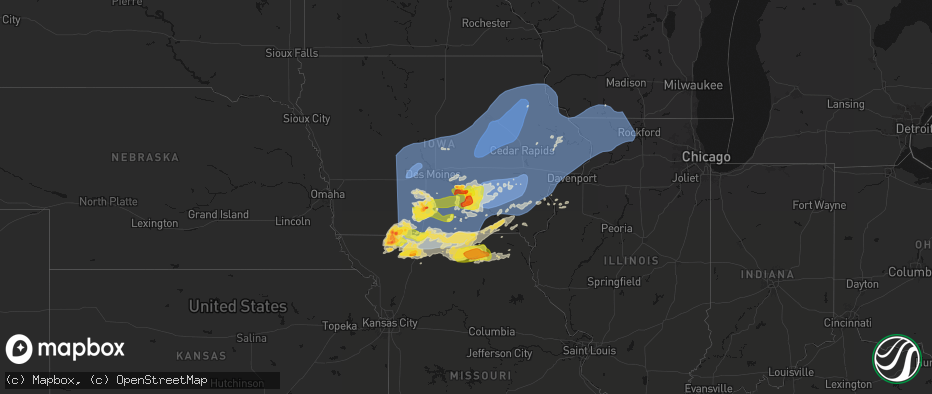
Hail Map on June 11, 2026
The weather event on June 11, 2026 includes Wind, Hail, and Tornado maps. 20 states and 2,417 cities were impacted and suffered possible damage. The total estimated number of properties impacted is 117,568.
Wind
Hail
Tornado
117,568
Estimated number of impacted properties by a 1.00" hail or larger18,754
Estimated number of impacted properties by a 1.75" hail or larger518
Estimated number of impacted properties by a 2.50" hail or largerStates Impacted by Hail Map on June 11, 2026
Storm reports
Oklahoma
| Date | Description |
|---|---|
| 06/11/20266:27 PM CDT | A local report indicates 1.75 inch wind near Union City |
| 06/11/20266:15 PM CDT | Report from mping. |
| 06/11/20266:07 PM CDT | A local report indicates 2.50 inch wind near 4 SSW El Reno |
| 06/11/20266:00 PM CDT | A local report indicates 1.75 inch wind near 1 W El Reno |
| 06/10/202611:30 PM CDT | 60 to 65 mph wind gust estimate near gideon. |
| 06/10/202610:11 PM CDT | Personal weather station... Measured at 10 m height. |
| 06/10/20269:55 PM CDT | A local report indicates 71 MPH wind near 4 NW Walters |
| 06/10/20269:35 PM CDT | Measured at kwso-tv. |
| 06/10/20269:35 PM CDT | One mile section of transmission lines blown down between se 45th and se 60th street along goodlin road. Time estimated from radar and surrounding reports. |
| 06/10/20269:34 PM CDT | Corrects time for previous tstm wnd gst report from 6 se lawton. Personal weather station... Measured at 10 m height. |
| 06/10/20269:30 PM CDT | Tree downed on a house. |
| 06/10/20269:29 PM CDT | Measured at klaw. |
| 06/10/20269:20 PM CDT | A local report indicates 59 MPH wind near 2 SSW Lawton |
| 06/10/20269:15 PM CDT | Tree damage near ft. Sill. Time estimated from radar. |
| 06/10/20267:30 PM CDT | At least 2 trees plus some power lines down in the city of miami. Time estimated from radar. |
| 06/10/20267:25 PM CDT | Relayed from social media. |
| 06/10/20267:20 PM CDT | Spotter reported gust south of miami on highway 69. |
| 06/10/20267:10 PM CDT | Report from mping. |
Virginia
| Date | Description |
|---|---|
| 06/11/20266:58 PM CDT | Numerous trees down through the county. |
| 06/11/20266:47 PM CDT | Tree down at leon road. |
| 06/11/20266:40 PM CDT | A couple trees were down in philomont. |
| 06/11/20266:32 PM CDT | Smattering of trees down into power lines and across roads in warrenton |
| 06/11/20266:31 PM CDT | A couple trees were down in round hill. |
| 06/11/20266:31 PM CDT | A couple trees were down in round hill. |
| 06/11/20266:26 PM CDT | *** 1 inj *** thunderstorm wind gust blew person in inflatable kayak out into silver lake. They were rescued in critical condition. |
| 06/11/20266:22 PM CDT | Tree down on north blue ridge turnpike. |
| 06/11/20266:14 PM CDT | Tree down at auburn road and wickcliffe road. |
| 06/11/20266:12 PM CDT | Tree down on road. Time estimated based on radar. |
| 06/11/20266:11 PM CDT | Tree down near intersection of bunker hill loop and mcdaniel road. |
| 06/11/20266:03 PM CDT | Numerous trees down in front royal. |
| 06/11/20266:03 PM CDT | Tree down off dickerson mill road... North of the intersection of shepherds store road. |
| 06/11/20265:55 PM CDT | Several trees down in rileyville. |
| 06/11/20265:55 PM CDT | Several trees were down around and north of luray. |
| 06/11/20265:55 PM CDT | Large tree was downa long the 3000 block of kimball road in luray. |
| 06/11/20265:54 PM CDT | Multiple trees were down across frederick county. |
| 06/11/20265:53 PM CDT | Tree blown down off dickerson mill road near sumdat trail. |
| 06/11/20265:52 PM CDT | Tree blown down at intersection of dickerson mill road and mead valley road. |
| 06/11/20265:48 PM CDT | Large tree branch down at residence |
| 06/11/20265:46 PM CDT | Tree blown down along saunders grove drive... South of cochese drive. |
| 06/11/20265:43 PM CDT | Major tree down on michael road... With several trees reported down on nearby streets |
| 06/11/20265:37 PM CDT | A local report indicates 1.00 inch wind near 1 ENE Stewartsville |
| 06/11/20265:32 PM CDT | Multiple reports of trees and power lines down across shenandoah county. |
| 06/11/20265:13 PM CDT | Large tree down blocking both directions of brocks gap rd. West of folks run. |
| 06/10/20268:05 PM CDT | Tree down on 900 block of crestwood drive. |
| 06/10/20267:25 PM CDT | Mutliple reports of trees and power lines down throughout the city of alexandria. |
| 06/10/20267:21 PM CDT | Quantico reported a 51 knot gust as thunderstorms/outflow moved through |
| 06/10/20267:07 PM CDT | There were three separate calls for trees that fell onto houses in fairfax. |
Michigan
| Date | Description |
|---|---|
| 06/11/202612:36 AM CDT | Numerous large tree limbs down some on houses along taft rd near muskrat run |
| 06/11/202612:36 AM CDT | Photos of snapped and bent power poles... Siding damage... And blown in garage doors. Short damage path consistent with straight line winds. |
| 06/11/202612:02 AM CDT | A large tree and wires were blown down do to thunderstorms winds. |
| 06/10/202611:58 PM CDT | *** 1 inj *** media relayed photos of a large tree down on a house... Partially destroying a chimney. |
| 06/10/202611:58 PM CDT | Media relayed photos of a large tree down on a house... Partially destroying a chimney. |
| 06/10/202611:46 PM CDT | Report of multiple large trees and wires down across northern monroe county. |
| 06/10/202611:20 PM CDT | A large tree was blown down due to thunderstorm winds. |
| 06/10/202611:19 PM CDT | Social media photo shows tree down in onsted. |
| 06/10/202610:55 PM CDT | Large branches down 6 inches to a foot in diameter. |
| 06/10/202610:25 PM CDT | Powerlines down. |
| 06/10/202610:25 PM CDT | 3-6 diameter limbs damaged... Numerous smaller branches downed. |
| 06/10/202610:25 PM CDT | Large 1-2ft diameter healthy limb down on a tree. Several 6-8 inch diameter limbs downed in the area. |
| 06/10/202610:17 PM CDT | A local report indicates 58 MPH wind near 1 NW Sturgis |
| 06/10/202610:10 PM CDT | Trees and powerlines down. |
| 06/10/202610:00 PM CDT | Tree and utility pole down onto house. |
| 06/10/20269:55 PM CDT | Truck blown off the road. |
| 06/10/20269:47 PM CDT | Social media photo shows large branch split from tree onto road. |
| 06/10/20269:42 PM CDT | Shavehead lake on the southside chanel has very large trees uprooted and landed on a house... A gazebo was destroyed and a shed was destroyed. |
| 06/10/20269:32 PM CDT | Social media photo shows tree uprooted in laingsburg... Mi. |
| 06/10/20268:51 PM CDT | Extensive tree damage with multiple trees down along m 66 just past bippley road. |
| 06/10/20268:43 PM CDT | Trees down. Time estimated with radar. |
| 06/10/20268:32 PM CDT | Reports of trees down in the area and to the east. Time estimated with radar. |
| 06/10/20268:19 PM CDT | Tree on roadway. |
| 06/10/20268:09 PM CDT | Trees and wires down at cutler and cedar street in allegan mi. |
| 06/10/20268:05 PM CDT | Trees and wires down on yard along west mckinley avenue. |
| 06/10/20268:00 PM CDT | Trees and power lines down. |
| 06/10/20267:55 PM CDT | 6 inch brand down at intersection of chicago and south waverly in holland. |
West Virginia
| Date | Description |
|---|---|
| 06/11/20266:22 PM CDT | Power line down at johnnycake lane and rolling lane. |
| 06/11/20266:05 PM CDT | Tree down near morgan grove road. |
| 06/11/20266:00 PM CDT | Tree in roadway on wv-28 at mile marker 30.0. Time based on radar. |
| 06/11/20265:45 PM CDT | Tree in roadway on us-250n at mile marker 4.0. Time estimated based on radar. |
| 06/11/20265:40 PM CDT | A tree was down down along martinsburg road. |
| 06/11/20265:18 PM CDT | Tree damage resulting in 376 customers without power. Location and time are estimated by radar. |
| 06/11/20265:05 PM CDT | Tree down at arkansaw road. |
| 06/11/20264:58 PM CDT | Tree down near the intersection of jersey mountain rd. And orchard point rd. |
| 06/11/20264:54 PM CDT | Tree down along dickenson mountain road. |
| 06/11/20264:41 PM CDT | Trees and a power line down at welton orchard road and snyderville road. |
| 06/11/20264:40 PM CDT | Multiple reports of trees and power lines down near new creek... Wv. |
| 06/11/20264:35 PM CDT | Several trees snapped and uprooted in the ellis ridge and chenoweth creek area. One tree fell and damaged a shed. Time estimated based on radar. |
| 06/11/20264:32 PM CDT | Trees were down along spriggs road. |
| 06/11/20264:31 PM CDT | Tree damage resulting in 19 customers without power. Time is estimated by radar. |
| 06/11/20264:31 PM CDT | Multiple reports of trees and power lines down near keyser wv. |
| 06/11/20264:25 PM CDT | Tree in roadway on cr-219/15 |
| 06/11/20264:22 PM CDT | Tree damage resulting in 37 customers without power. Time is estimated by radar. |
| 06/11/20264:20 PM CDT | Multiple large hardwoods snapped and uprooted in the 1100 block of aspen ln. Outbuildings and porch destroyed by fallen trees. |
| 06/11/20264:10 PM CDT | Tree down. Time estimated based on radar. |
| 06/11/20264:00 PM CDT | Tree in roadway. Time estimated based on radar. |
| 06/11/20263:50 PM CDT | Tree down blocking roadway. Another tree on house in the area. Time estimated based on radar. |
| 06/11/20263:50 PM CDT | Tree knocked powerline down. Time estimated based on radar. |
| 06/11/20263:48 PM CDT | Power line down. Time estimated based on radar. |
| 06/11/20263:45 PM CDT | Numerous trees and power lines down across the county... Specifically south of buckhannon. |
| 06/11/20263:45 PM CDT | Tree took down power lines. Time estimated based on radar. |
| 06/11/20263:45 PM CDT | Tree down. Time estimated based on radar. |
| 06/11/20263:44 PM CDT | Several trees down at the buckhannon country club... With some damage reported to the clubhouse. Time is estimated by radar. |
| 06/11/20263:40 PM CDT | Wires down along nicholson loop road. Time estimated via radar. |
| 06/11/20263:40 PM CDT | Tree down across loveberry run rd at laurel run rd. Time estimated from radar. |
| 06/11/20263:37 PM CDT | Wires down across kingwood pike with a transformer fire. Time estimated via radar. |
| 06/11/20263:35 PM CDT | Tree down blocking the road. Time estimated via radar. |
| 06/11/20263:30 PM CDT | Tree fell on house. Time estimated based on radar. |
| 06/11/20263:30 PM CDT | Tree down blocking snake hill road. Time estimated via radar. |
| 06/11/20263:25 PM CDT | Large tree blocking the roadway. Time estimated via radar. |
| 06/11/20263:25 PM CDT | Tree down near old route 73 and greenville school road. Time estimated via radar. |
| 06/11/20263:20 PM CDT | Tree on house. Time estimated based on radar. |
| 06/11/20263:20 PM CDT | Tree down on wires blocking the road. Time estimated via radar. |
| 06/11/20263:20 PM CDT | Two power poles broken. Time estimated based on radar. |
| 06/11/20263:20 PM CDT | Tree down on house. Time estimated based on radar. |
| 06/11/20263:17 PM CDT | Several large trees and wires down along grafton road. Time estimated via radar. |
| 06/11/20263:15 PM CDT | Tree down across hildebrand lock and dam road blocking the entire road. Time estimated via radar. |
| 06/11/20263:10 PM CDT | Three trees down on wires blocking the road. Time estimated via radar. |
| 06/11/20263:10 PM CDT | Multiple trees down in the area. Time estimated based on radar. |
| 06/11/20263:05 PM CDT | Trees and wires down along fort hill and thorne drive. Time estimated via radar. |
| 06/11/20263:05 PM CDT | Tree down along river road near intersection with hagans road. Time estimated via radar. |
| 06/11/20263:00 PM CDT | Tree down blocking solomon road. Time estimated via radar. |
| 06/11/20262:59 PM CDT | Tree down on fairmont rd. |
| 06/11/20262:55 PM CDT | Tree down across fairmont road blocking the roadway. Time estimated via radar. |
| 06/11/20262:43 PM CDT | Tree in roadway on cr-28/2 |
| 06/11/20262:40 PM CDT | Tree in roadway on cr-28 |
| 06/11/20262:30 PM CDT | Tree in roadway on cr-50/30 sunnyside rd. Time estimated based on radar. |
| 06/11/20262:25 PM CDT | Tree in roadway on cr-2 |
| 06/11/20262:15 PM CDT | Lines down. Time estimated based on radar. |
| 06/11/20261:55 PM CDT | Trees down along north fork road. Time estimated via radar. |
| 06/11/20261:50 PM CDT | Trees down in wileyville. Time estimated via radar. |
| 06/11/20261:35 PM CDT | Several trees down on mahan lane. Time estimated via radar. |
| 06/11/20261:33 PM CDT | Tree down on archer hill road near highland hills drive blocking the road. Time estimated via radar. |
North Carolina
| Date | Description |
|---|---|
| 06/11/20265:50 PM CDT | Tree down on powerlines near poole road and huntsboro road. |
| 06/11/20265:47 PM CDT | Tree down on roadway. |
| 06/11/20265:40 PM CDT | Trees down in middlesex/bailey. |
| 06/11/20265:40 PM CDT | Road closed due to trees on roadway. |
| 06/11/20265:10 PM CDT | Tree down on hwy 258. |
| 06/11/20265:05 PM CDT | Metal carport blown over off bulluck school road. |
| 06/11/20265:05 PM CDT | Trees down near bulluck elem school. |
| 06/11/20264:55 PM CDT | Tree down on us hwy 301 in battleboro. |
| 06/11/20264:50 PM CDT | Tree down along us 64e. |
| 06/11/20264:45 PM CDT | Large boat on trailer slide 10-15ft off concrete pad due to strong wind gusts. |
| 06/11/20264:40 PM CDT | Tree struck by lightning and fell into roadway. |
| 06/11/20264:40 PM CDT | Large trees down on raleigh road and nashville rd. |
| 06/11/20264:29 PM CDT | Trees down on powerlines with multiple areas without power across red oak and northern nashville nc. |
| 06/10/20268:13 PM CDT | Tree down on powerlines. |
| 06/10/20267:33 PM CDT | Tree down on powerlines off nor-am road. |
| 06/10/20267:06 PM CDT | Corrects the time of previous tstm wnd dmg report from 3 sse nahunta. Tree down on powerlines off nor-am road. |
Minnesota
| Date | Description |
|---|---|
| 06/11/20264:57 PM CDT | Storm with gusty winds and broke a dead elm tree. Storm also produced pea size hail. 0.44 inches of rain from storm. |
| 06/11/202610:30 AM CDT | Tree split. |
| 06/11/202610:30 AM CDT | Several trees blown down. |
New Jersey
| Date | Description |
|---|---|
| 06/10/20269:15 PM CDT | Downed trees near the intersection of libertyville rd and county road 519. Time estimated by radar. |
| 06/10/20269:10 PM CDT | Trees down near thomas lane. Time estimated by radar. |
| 06/10/20268:49 PM CDT | Several reports of trees and wires down in morristown. Time estimated from radar. |
| 06/10/20268:45 PM CDT | Large tree branch down on willow way in berkeley heights. |
| 06/10/20268:34 PM CDT | Reports of numerous trees and wires down across the town of mendham. |
District of Columbia
| Date | Description |
|---|---|
| 06/10/20267:32 PM CDT | A tree was down along 154 d street se. |
| 06/10/20267:25 PM CDT | A tree was down along the 700 block of 16th street se. |
| 06/10/20267:24 PM CDT | Personal weather station in logan circle reported 53 kts |
| 06/10/20267:17 PM CDT | A local report indicates 60 MPH wind near Reagan National Arpt |
| 06/10/20267:16 PM CDT | A tree was down along 27th street and dumbarton street nw. |
| 06/10/20267:09 PM CDT | Several calls for trees down around glen echo |
Missouri
| Date | Description |
|---|---|
| 06/11/20265:51 PM CDT | Quarter-sized hail reported by spotters. Report relayed by em. |
| 06/11/20264:20 PM CDT | Several large tree limbs down. |
| 06/11/202610:30 AM CDT | Multiple reports of power lines down and power outages in southern adair county. Time based on social media reports and confirmed from radar. |
| 06/11/202610:29 AM CDT | Corrects previous tstm wnd dmg report from la plata. Large tree branches snapped... Trees uprooted. Report relayed from social media. Time estimated from radar. |
| 06/11/20268:31 AM CDT | Report relayed by em. Time estimated from radar. |
| 06/11/20268:30 AM CDT | Social media report of tree limbs down at a residence near princeton. Time estimated from radar. |
| 06/11/20268:28 AM CDT | Social media report. Time estimated from radar. |
| 06/11/20268:26 AM CDT | Quarter sized hail reported in bethany. |
| 06/11/20268:25 AM CDT | Ping pong ball sized hail reported at the junction of us 136 and us 69. |
| 06/11/20268:15 AM CDT | Estimated 60 to 65 mph gusts in mercer. |
| 06/11/20267:20 AM CDT | Report relayed from social media. Time estimated from radar. |
| 06/10/20269:44 PM CDT | Report of a tree down on highway 59 past two sons campground. |
| 06/10/20268:43 PM CDT | Social media report. Time estimated from radar. |
| 06/10/20268:43 PM CDT | Social media report of a downed tree limb at a residence in clinton. Time estimated from radar. |
| 06/10/20268:36 PM CDT | Report relayed via social media. Time estimated from radar. |
| 06/10/20268:35 PM CDT | Time confirmed from radar. |
| 06/10/20268:33 PM CDT | Report relayed by em. |
| 06/10/20268:22 PM CDT | A local report indicates 2.00 inch wind near Appleton City |
New York
| Date | Description |
|---|---|
| 06/11/20266:07 PM CDT | Tree down over black river road. |
| 06/11/20266:07 PM CDT | Tree down over baltimore avenue. |
| 06/11/20266:03 PM CDT | Tree down over roadway on chestnut street. |
| 06/11/20266:03 PM CDT | Tree and wires down over riverside drive. |
| 06/11/20265:35 PM CDT | Tree down over river road in lisle. |
| 06/11/20265:16 PM CDT | Tree down over roadway on honeypot road. |
| 06/11/20265:08 PM CDT | Picture of large tree down on south country road in remsenburg. |
| 06/11/20265:08 PM CDT | Widespread trees and wires down across shirley... Mastic and mastic beach. |
| 06/11/20265:05 PM CDT | Large tree down on wading river road in manorville. Time estimated by radar. |
| 06/11/20265:05 PM CDT | Branches... And fences are becoming damaged. |
| 06/11/20265:02 PM CDT | Multiple trees and wires down. |
| 06/11/20265:00 PM CDT | Multiple trees and wires down across ridge. |
| 06/11/20264:55 PM CDT | Video of wires down causing a fire on gully road in wading river. Time estimated by radar. |
| 06/11/20264:55 PM CDT | 66 mph wind gusts recorded at mesonet station dvi03260 shoreham. |
| 06/11/20264:55 PM CDT | Video of multiple trees down across wading river. |
| 06/11/20264:55 PM CDT | Multiple trees and wires down across rocky point. |
| 06/11/20264:55 PM CDT | Wires down on academy street. Radar-estimated time of impact. |
| 06/11/20264:50 PM CDT | Tree down along clock road. Radar-estimated time of impact. |
| 06/11/20264:47 PM CDT | Multiple reports of trees and wires down throughout corning. |
| 06/11/20264:47 PM CDT | Powerline fell on house and resulted in a fire that was later put out. |
| 06/11/20264:40 PM CDT | Wires down at warren and north main. Radar-estimated time. |
| 06/11/20264:40 PM CDT | Tree down along taylor street. Radar-estimated time of impact. |
| 06/11/20264:38 PM CDT | Tree down on route 115 north of lindley. |
| 06/11/20264:38 PM CDT | Power pole down near middle rd and burch hill rd. |
| 06/11/20264:00 PM CDT | Tree and wires down on halsey st. |
| 06/11/20263:40 PM CDT | Power poles and trees down near nichols rd causing a traffic backup. |
| 06/11/20263:38 PM CDT | Power line down... Causing arcing and a small grass fire. |
| 06/11/20263:38 PM CDT | Tree... Power pole... And wires down across club seneca rd. |
| 06/11/20263:38 PM CDT | A local report indicates 1.75 inch wind near 1 S Pawling |
| 06/11/20263:35 PM CDT | A local report indicates 1.75 inch wind near Pawling |
| 06/11/20263:30 PM CDT | Social media report of hail up to 2 inches in diameter near route 22 and west mountain in pawling. |
| 06/11/20263:30 PM CDT | Multiple photos on social media of quarter to 1.25 inch hail in pawling. |
| 06/11/20263:30 PM CDT | Trained spotter in the village of pawling sent pictures of hail with sizes ranging between 1 inch to 1.5 inches. |
| 06/11/20263:26 PM CDT | Multiple reports of tree and wires down. |
| 06/11/20263:25 PM CDT | Hail in wingdale estimated between 1.25 and 1.50 inches based on pictures. |
| 06/11/20263:21 PM CDT | Multiple reports of trees and wires down across the town. |
| 06/11/20263:20 PM CDT | Tree down on ny 22 northbound near the intersection of chippawalla road in dover. |
| 06/11/20263:19 PM CDT | Tree down on roy rd. |
| 06/11/20263:11 PM CDT | Multiple reports of trees and wires down across the town and village. |
| 06/11/20263:11 PM CDT | Tree and wires down in roadway. |
| 06/11/20262:57 PM CDT | Tree down on route 54. |
| 06/11/20262:45 PM CDT | Multiple reports of trees and wires down across the town. |
| 06/11/20262:45 PM CDT | Multiple reports of trees and wires down across the town. |
| 06/11/20262:42 PM CDT | Tree down blocking roadway. |
| 06/11/20262:37 PM CDT | Tree down on trevett rd in the town of concord. |
| 06/11/20262:11 PM CDT | Tree down. |
| 06/11/20262:10 PM CDT | Tree fell on vehicle. |
| 06/11/20261:56 PM CDT | Tree on power line catching fire on route 82 near doodletown road. |
| 06/11/20261:56 PM CDT | Wires down in the road near the intersection of church road and willowbrook road in the town of livingston. |
| 06/11/20261:55 PM CDT | Trees and wires down between cr 10 and cr 15 along route 82 in the town of taghkanic. |
| 06/11/20261:45 PM CDT | Tree down along intersection of schneider road and cr10 in the town of livingston. |
| 06/11/20261:37 PM CDT | Corrects previous tstm wnd dmg report from 3 wsw springville for timing. Tree down on trevett rd in the town of concord. |
| 06/11/202612:37 PM CDT | Corrects previous tstm wnd dmg report from 3 wsw springville due to zulu conversion error. Tree down on trevett rd in the town of concord. |
| 06/10/202611:06 PM CDT | Multiple trees down and knocked over along and in the vicinity of brookside court between strong avenue and great neck road. Time estimated by radar. |
| 06/10/202610:45 PM CDT | Downed tree on the major deegan at exit 11. Exact time estimated by radar. |
| 06/10/202610:39 PM CDT | Asos station klga nyc/la guardia. |
| 06/10/202610:30 PM CDT | Large tree limb onto home. Exact time estimated by radar. |
| 06/10/20267:20 PM CDT | 2 trees down blocking the roadway. Time estimated by radar. |
Connecticut
| Date | Description |
|---|---|
| 06/11/20264:20 PM CDT | Tree snapped in half. |
| 06/11/20264:20 PM CDT | Tree down on car on route 12 in gales ferry. |
| 06/11/20264:10 PM CDT | Tree down with wires across route 34 at great hill road and fountain lake road. Road is closed. |
| 06/11/20264:00 PM CDT | Tree down on wires with small fire on milwaukee ave near oxford street. |
| 06/11/20263:46 PM CDT | Tree limbs down causing a power outage near candle hill road in inglenook. |
| 06/11/20263:32 PM CDT | Tree limbs down causing a power outage near taber road in sherman. |
| 06/11/20263:32 PM CDT | Multiple videos show quarter-sized hail falling in sherman. |
| 06/11/20263:30 PM CDT | Tree down on wires down on oxford road... Oneill road and coppermine road in oxford ct. |
| 06/11/20263:25 PM CDT | Tree down on wires on homestead ave between middlefield and woodland ave. |
| 06/11/20263:23 PM CDT | Tree limbs down causing a power outage in seymour. |
| 06/11/20263:22 PM CDT | Tree limbs down causing a power outage near chauncey drive in oxford. |
| 06/11/20262:45 PM CDT | Tree down on wires on west morris road in the town of bantam. |
| 06/11/20262:29 PM CDT | A local amateur radio operator reported downed trees and wires on lower river road in west cornwall which ultimately led to a brief closure of the road. |
| 06/11/20262:29 PM CDT | An amateur radio operator reported a tree down on wires on river road just north of the center of west cornwall. |
Wisconsin
| Date | Description |
|---|---|
| 06/11/20266:27 PM CDT | Sheboygan airport. |
| 06/11/20266:12 PM CDT | National weather service storm survey confirms a tornado rated ef-1 near somers. Brief tornado began on the south side of 18th street west of 72nd ave. Two barn outbuil |
| 06/11/20266:10 PM CDT | Touchdown near the intersection of us hwy 45 and wi hwy 142. |
| 06/11/20266:10 PM CDT | Several large branches down on 136th ave just s of hwy 142. Possible tornado. |
| 06/11/20265:35 PM CDT | Large branch down on hill st in walworth. Time est from radar. |
| 06/11/202611:15 AM CDT | Tree down near 23rd and pine street. Time estimated from radar. |
| 06/11/202611:10 AM CDT | Tree down on two cars. Time estimated from radar. |
| 06/11/202611:10 AM CDT | A number of trees and limbs down in la crosse and onalaska. Time estimated from radar. |
Indiana
| Date | Description |
|---|---|
| 06/10/202610:53 PM CDT | Tree downed along mcminn road. Time estimated by radar. |
| 06/10/202610:53 PM CDT | Tree downed in richmond. Time estimated by radar. |
| 06/10/202610:40 PM CDT | Tree in the roadway on state road 44 near the west county line. |
| 06/10/202610:30 PM CDT | Trees down north of state road 44 and east of 500 east. Time estimated. |
| 06/10/202610:30 PM CDT | Thunderstorm winds caused significant roof damage to east side of 2 story building. Time estimated from radar. |
| 06/10/202610:25 PM CDT | Tree into house. |
| 06/10/202610:25 PM CDT | Trees down. |
| 06/10/202610:20 PM CDT | Numerous 6-8 diameter or less limbs downed... A couple of uprooted pines between wall lake and the greenlawn cemetery areas near orland... In. |
| 06/10/202610:20 PM CDT | Corrects previous non-tstm wnd gst report from 4 wsw woodburn. |
| 06/10/202610:20 PM CDT | Thunderstorm winds destroyed metal barn on county road 550 east. Time estimated from radar. |
| 06/10/202610:17 PM CDT | Ef0 tornado with max winds 70 mph tracked 0.32 miles to ese creating a clear circulation pattern within corn field. Minor damage to an vehicle and awning and propane ta |
| 06/10/202610:15 PM CDT | A local report indicates 70 MPH wind near Mahon |
| 06/10/202610:13 PM CDT | Multiple trees and power lines down in muncie. |
| 06/10/202610:12 PM CDT | A shed was destroyed from a nearby trailer park. |
| 06/10/202610:10 PM CDT | Thunderstorm winds caused significant tree damage in south franklin area with roof damage on knapp and mitthoeffer roads. Time estimated from radar. |
| 06/10/202610:10 PM CDT | Numerous 6-8 inch diameter or less limbs downed around the area between brighton and howe... In. Pine tree snapped halfway |
| 06/10/202610:08 PM CDT | A local report indicates 70 MPH wind near 2 ENE Nine Mile |
| 06/10/202610:08 PM CDT | House crushed by tree. Time estimated via radar. |
| 06/10/202610:05 PM CDT | Large mature white pine snapped off 15 feet above ground... Large locust tree uprooted... Large limbs stripped from mature oak and maple trees. |
| 06/10/202610:03 PM CDT | 30 ft long live tree branch 7 to 8 inches diameter is down across peterman road. |
| 06/10/202610:00 PM CDT | Numerous reports of damage. |
| 06/10/202610:00 PM CDT | Tree snapped. |
| 06/10/202610:00 PM CDT | A local report indicates 66 MPH wind near 1 S Bluffton |
| 06/10/202610:00 PM CDT | Along sr-120... Especially near/west of n 450 w through approximately sr-5. Structural damage to a silo... Barns... And some shingle and siding damage on several homes. |
| 06/10/20269:58 PM CDT | Thunderstorm winds downed tree limb and power lines onto building roof resulting in arcing wires from a light pole which caused a fire in apartment attic. Time estimate |
| 06/10/20269:55 PM CDT | A local report indicates 59 MPH wind near 2 NNW Elkhart |
| 06/10/20269:55 PM CDT | Several trees and large branches down. |
| 06/10/20269:52 PM CDT | 18 inch diameter tree uprooted. Time estimated via radar. |
| 06/10/20269:50 PM CDT | Reports of power lines down in the lapel and anderson areas. |
| 06/10/20269:50 PM CDT | Corrects time of previous tstm wnd gst report from mahon. |
| 06/10/20269:45 PM CDT | Several homes damaged and trees down. |
| 06/10/20269:44 PM CDT | Several trees down. |
| 06/10/20269:43 PM CDT | A local report indicates 75 MPH wind near 2 N North Webster |
| 06/10/20269:42 PM CDT | Large tree and numerous branches down. |
| 06/10/20269:42 PM CDT | Thunderstorm winds caused significant wind damage in cartersburg. Time estimated from radar. |
| 06/10/20269:42 PM CDT | Damage to a house. |
| 06/10/20269:35 PM CDT | Roof ripped off house. |
| 06/10/20269:35 PM CDT | A local report indicates 60 MPH wind near 3 WNW Jonesboro |
| 06/10/20269:32 PM CDT | Several trees down. |
| 06/10/20269:31 PM CDT | Large tree branch snapped... Laying across a road. |
| 06/10/20269:30 PM CDT | Large pine trees topped... Wood picket fence snapped... Grass and dirt plastered to buildings. |
| 06/10/20269:30 PM CDT | Tree down across road. From social media. Time estimated from radar. |
| 06/10/20269:30 PM CDT | Siding ripped off the house. 2 trees down. Part of the roof of the barn is across the road in the woods stuck in trees. |
| 06/10/20269:30 PM CDT | Numerous trees down in the south bend area. |
| 06/10/20269:30 PM CDT | Tree damage. |
| 06/10/20269:30 PM CDT | *** 1 inj *** one injury due to downed tree at white river campground. |
| 06/10/20269:27 PM CDT | Tree on house and multiple broken limbs. |
| 06/10/20269:25 PM CDT | Multiple trees and power lines throughout howard county. |
| 06/10/20269:24 PM CDT | A local report indicates 60 MPH wind near 5 W Atlanta |
| 06/10/20269:22 PM CDT | House shifted off foundation and windows blown out. Several trees down in the area. |
| 06/10/20269:22 PM CDT | Multiple structures impacted. |
| 06/10/20269:20 PM CDT | A local report indicates 67 MPH wind near 2 ENE Cecil Harden Lake |
| 06/10/20269:19 PM CDT | Measured from personal weather station. |
| 06/10/20269:15 PM CDT | Trees and power lines down in the county... Especially along the 331 corridor and across 10 to argos. |
| 06/10/20269:15 PM CDT | Tree on powerlines. |
| 06/10/20269:10 PM CDT | Thunderstorm winds downed numerous trees on to roads and power lines. |
| 06/10/20269:07 PM CDT | A local report indicates 65 MPH wind near Peru |
| 06/10/20269:04 PM CDT | A local report indicates 64 MPH wind near Grissom Afb |
| 06/10/20269:02 PM CDT | Four large trees down. |
| 06/10/20269:00 PM CDT | Measured from personal weather station. |
| 06/10/20269:00 PM CDT | Trees down across the street from church. Branches estimated 2-4 in. Diameter. |
| 06/10/20269:00 PM CDT | 8 healthy trees down... 12 to 14 inches in diameter. |
| 06/10/20269:00 PM CDT | Large trees damaged in a straight line. |
| 06/10/20268:59 PM CDT | Measured from personal weather station. |
| 06/10/20268:55 PM CDT | Tree down. |
| 06/10/20268:52 PM CDT | Numerous trees down. |
| 06/10/20268:51 PM CDT | Measured from personal weather station. |
| 06/10/20268:47 PM CDT | Tree downed onto truck. |
| 06/10/20268:35 PM CDT | Thunderstorm winds downed large tree onto 9th street. Time estimated from radar. |
| 06/10/20268:30 PM CDT | Several large trees down. |
| 06/10/20268:30 PM CDT | 2 semis blown over on i-65. |
| 06/10/20268:28 PM CDT | Confirmed touchdown via ema. |
| 06/10/20268:24 PM CDT | Peak gust measured on personal weather station before data stopped being reported. |
| 06/10/20268:20 PM CDT | Thunderstorm winds downed trees in fountain county. Time estimated from radar. |
| 06/10/20268:20 PM CDT | Thunderstorm winds downed trees and affected barns in warren county. Time estimated from radar. |
| 06/10/20268:15 PM CDT | Tornado on the ground north of kouts. Time estimated by radar. |
| 06/10/20268:05 PM CDT | Report of snapped corn and flipped over irrigation system. Time estimated by radar. |
| 06/10/20268:05 PM CDT | Peak gust measured on personal weather station. |
| 06/10/20268:02 PM CDT | Trained spotter report of tornado near 900 south road and 200 west road with debris in the air. |
| 06/10/20268:00 PM CDT | Private weather station kinkentl6 reported 69 mph wind gust just prior to gauge outage. |
| 06/10/20267:58 PM CDT | Storm chaser video shows tornado southeast of hebron. |
| 06/10/20267:57 PM CDT | Public report of damage to trees and outbuildings southwest of kentland. Time estimated by radar. |
| 06/10/20267:51 PM CDT | Public report of tornado on the grand east of lowell near i-65. |
| 06/10/20267:33 PM CDT | Public report of roof damage and fence damage on drummond street in southwest cedar lake. Time estimated by radar. |
| 06/10/20267:25 PM CDT | Roof damage to andrean high school in merrillville. Multiple large branches broken in the vicinity. Possible tornado. Relayed via broadcast media. |
| 06/10/20267:16 PM CDT | Multiple large branches broken... Tree branches on house... Near 93rd avenue and northcote avenue. |
Pennsylvania
| Date | Description |
|---|---|
| 06/11/20266:51 PM CDT | Tree down on wires on east main street. |
| 06/11/20266:49 PM CDT | Multiple trees down on wires in fairview and monaghan townships. |
| 06/11/20266:48 PM CDT | Tree down on roadway. |
| 06/11/20266:46 PM CDT | Tree down on north king street. |
| 06/11/20266:45 PM CDT | Multiple trees and wires down which caused a few temporary road closures from east of tunkhannock to the wyoming-luzerne-lackwanna tri-section. Radar-estimated time. |
| 06/11/20266:44 PM CDT | Tree down on roadway. |
| 06/11/20266:42 PM CDT | Tree down on roadway between intersection of old forge rd and shauffnertown rd. |
| 06/11/20266:38 PM CDT | Electrical wires down on webster school road. |
| 06/11/20266:38 PM CDT | Multiple trees down in riverside. |
| 06/11/20266:36 PM CDT | Tree down on 1350 pleasant dr. |
| 06/11/20266:35 PM CDT | Tree down blocking roadway. |
| 06/11/20266:33 PM CDT | Trees down on bradley cir. |
| 06/11/20266:31 PM CDT | Tree down into power lines. |
| 06/11/20266:31 PM CDT | Tree down into power lines on fishing creek rd. |
| 06/11/20266:30 PM CDT | Tree down across n lewisberry rd. |
| 06/11/20266:30 PM CDT | Multiple trees down on roadways in montrose. |
| 06/11/20266:30 PM CDT | Tree down on clarks valley rd. |
| 06/11/20266:29 PM CDT | Tree down into wires on old depot rd. |
| 06/11/20266:23 PM CDT | Tree down on chestnut grove rd. |
| 06/11/20266:18 PM CDT | Wires down on villa view dr. |
| 06/11/20266:13 PM CDT | Wires down on harrisburg pike. |
| 06/11/20266:13 PM CDT | Tree down on king ave. Time estimated by radar. |
| 06/11/20266:09 PM CDT | Wires down on intersection of middle ridge rd and cemetery rd. |
| 06/11/20266:05 PM CDT | Late report of trees down on stevens hill road in sugarloaf township. |
| 06/11/20266:01 PM CDT | Tree down blocking roadway. |
| 06/11/20266:00 PM CDT | Wires down on n fayette st. |
| 06/11/20266:00 PM CDT | Tree down on spring rd. |
| 06/11/20266:00 PM CDT | Wires down on talhelm rd. Time estimated by radar. |
| 06/11/20265:57 PM CDT | Tree on wires blocking roadway near warm springs lodge on warm springs rd. |
| 06/11/20265:55 PM CDT | Numerous downed trees and wires reported around pa-284 and pa-287. |
| 06/11/20265:40 PM CDT | Tree down on 25235 rte 35 n. |
| 06/11/20265:40 PM CDT | Tree down on horningtown rd. |
| 06/11/20265:35 PM CDT | Report of tree down in turbett township. |
| 06/11/20265:32 PM CDT | Tree down over roadway. |
| 06/11/20265:25 PM CDT | Tree down at mccoysville road and quarry road. |
| 06/11/20265:25 PM CDT | Trees and wires down on loop rd. |
| 06/11/20265:23 PM CDT | Tree and wires down near mountain road. |
| 06/11/20265:23 PM CDT | Tree down on farrandsville road and railroad bridge lane. |
| 06/11/20265:17 PM CDT | Wires down along 1st street. |
| 06/11/20265:10 PM CDT | Wires down by aspen road and renovo road. |
| 06/11/20265:04 PM CDT | Trees down on wires spring creek road. |
| 06/11/20265:02 PM CDT | Photo submitted of tree damage on limerock terrace. |
| 06/11/20265:02 PM CDT | Trees and wires down on w beaver ave. |
| 06/11/20265:02 PM CDT | Downed wires and trees on slacks run road. |
| 06/11/20265:00 PM CDT | Tree down on aughwick creek rd near runk rd. Time estimated by radar. |
| 06/11/20265:00 PM CDT | Trees and wires down in the hills creek state park area near lake road. |
| 06/11/20264:58 PM CDT | Wires down on w buffalo run rd. |
| 06/11/20264:55 PM CDT | Wires down along warriors mark path. |
| 06/11/20264:54 PM CDT | Tree down on wires by intersection of pa-45 and pa-453. |
| 06/11/20264:52 PM CDT | Report of downed trees in snow shoe township. |
| 06/11/20264:52 PM CDT | Reports of trees down near route 184 in cogan house township. |
| 06/11/20264:40 PM CDT | Tree down over road halfway between town center and the intersection with spruce creek road. |
| 06/11/20264:35 PM CDT | Corrects previous tstm wnd dmg report from 3 wsw driftwood. Tree down blocking roadway on mix run road. |
| 06/11/20264:35 PM CDT | Tree and wires down on woodbury pike. |
| 06/11/20264:32 PM CDT | Trees and wires down on juniata river road in woodbury township. |
| 06/11/20264:30 PM CDT | Corrects previous tstm wnd dmg report from 2 nne osterburg. Trees and wires down on shellsbugh road that caused small brushfire. |
| 06/11/20264:30 PM CDT | Trees and wires down on shellsbugh road that caused small brushfire. |
| 06/11/20264:27 PM CDT | Trees and wires down near intersection of south dakota road and sarah furnace road. |
| 06/11/20264:23 PM CDT | Tree down on plank rd. |
| 06/11/20264:17 PM CDT | Tree down on carson valley rd. |
| 06/11/20264:15 PM CDT | Tree fell on wires near intersection of davis road and gwin road. Time estimated by radar. |
| 06/11/20264:14 PM CDT | Trees and wires down on hollow road. |
| 06/11/20264:12 PM CDT | Wires down by short ave and country club rd. |
| 06/11/20264:11 PM CDT | Trees down near state park road and anderson creek road. |
| 06/11/20264:08 PM CDT | Tree down by green bridge rd and emerick rd. |
| 06/11/20264:08 PM CDT | Tree down on shaffer mountain rd. |
| 06/11/20264:04 PM CDT | Tree down in yard. |
| 06/11/20264:03 PM CDT | Numerous trees down across berlin... Pa. |
| 06/11/20264:03 PM CDT | Trees and wires down in bradford township. |
| 06/11/20264:02 PM CDT | Wires down on spruce st & pennsylvania ave. |
| 06/11/20264:02 PM CDT | Wires down on westminster dr. |
| 06/11/20264:00 PM CDT | Wires down on rockville rd. |
| 06/11/20264:00 PM CDT | Trees and wires down on lumber city highway. |
| 06/11/20263:56 PM CDT | Trees and wires blocking both lanes on hoover rd and husband rd. |
| 06/11/20263:56 PM CDT | Tree down on long ave. |
| 06/11/20263:47 PM CDT | Corrects previous tstm wnd dmg report from clymer. A few trees down near the clymer area. Time estimated from radar. |
| 06/11/20263:47 PM CDT | Tree down at intersection of crawfordtown road and brudnock drive. Time estimated via radar. |
| 06/11/20263:47 PM CDT | Numerous trees down in punxsutawney. Time estimated via radar. |
| 06/11/20263:47 PM CDT | Tree down near knox-dale road at panic-knoxdale road. |
| 06/11/20263:45 PM CDT | Tree down blocking both lanes of panic knoxdale road at intersection of knoxdale road. Time estimated via radar. |
| 06/11/20263:45 PM CDT | Wires down by 3rd st and hemlock st. |
| 06/11/20263:45 PM CDT | Tree down blocking both lanes. |
| 06/11/20263:45 PM CDT | Wires down on moonlite pk rd. |
| 06/11/20263:37 PM CDT | Tree down on st clair road and falcon drive. |
| 06/11/20263:37 PM CDT | A few trees down near the clymer area. Time estimated from radar. |
| 06/11/20263:37 PM CDT | Wires down on chime rd. |
| 06/11/20263:35 PM CDT | Tree down blocking roadway on mix run road. |
| 06/11/20263:30 PM CDT | Tree down blocking the road at intersection of melcroft road and buchanan road. Time estimated via radar. |
| 06/11/20263:15 PM CDT | Tree down along route 949. |
| 06/11/20262:58 PM CDT | Tree down covering two lanes of pa-31. |
| 06/11/20262:49 PM CDT | Tree and wires down. The wires are on fire. Time estimated via radar. |
| 06/11/20262:47 PM CDT | Trees down around mcclellandtown. Time estimated via radar. |
| 06/11/20262:45 PM CDT | Tree down along new geneva road. Time estimated via radar. |
| 06/11/20262:45 PM CDT | Recorded on home weather station. |
| 06/11/20262:45 PM CDT | Tree down on harmony church road blocking the road. Time estimated via radar. |
| 06/11/20262:44 PM CDT | Tree down blocking all of old dairy road. Time estimated via radar. |
| 06/11/20262:42 PM CDT | Tree down blocking the road at intersection of kepple road and stepp road. Time estimated via radar. |
| 06/11/20262:40 PM CDT | Tree down on wires along longvue dr. |
| 06/11/20262:36 PM CDT | Wires down at morgan street and cassin avenue. Time estimated via radar. |
| 06/11/20262:34 PM CDT | Tree down blocking browns ferry road. Time estimated via radar. |
| 06/11/20262:33 PM CDT | Roof blown off of a building and wires down. Time estimated via radar. |
| 06/11/20262:32 PM CDT | Tree down across yeash lane. Time estimated via radar. |
| 06/11/20262:31 PM CDT | Trees and wires down. Time estimated via radar. |
| 06/11/20262:30 PM CDT | Trees and wires down in new castle. Time estimated via radar. |
| 06/11/20262:30 PM CDT | Tree down along north eighty eight road. Time estimated via radar. |
| 06/11/20262:28 PM CDT | Tree down blocking the road at intersection of rockdale road and heller road. Time estimated via radar. |
| 06/11/20262:27 PM CDT | Large tree down. Time estimated via radar. |
| 06/11/20262:25 PM CDT | Large tree limbs down along ridge road near chatham university. Time estimated via radar. |
| 06/11/20262:19 PM CDT | Two trees down blocking the road. Time estimated via radar. |
| 06/11/20262:19 PM CDT | Tree down on power lines. Time estimated via radar. |
| 06/11/20262:16 PM CDT | Tree down on wires. Time estimated via radar. |
| 06/11/20262:12 PM CDT | Power lines down across the road. Time estimated via radar. |
| 06/11/20262:11 PM CDT | Tree down on wires along forsythe lane. Time estimated via radar. |
| 06/11/20262:10 PM CDT | Tree down on wires. Time estimated via radar. |
| 06/11/20262:09 PM CDT | Tree down along lindsay road just past the fedex building. Time estimated via radar. |
| 06/11/20262:04 PM CDT | Trees and wires down along wiegand drive. Time estimated via radar. |
| 06/11/20262:00 PM CDT | A tree fell across the road and onto two people. Unknown injuries. Time estimated via radar. |
| 06/11/20261:59 PM CDT | Flaugherty run road blocked by at least one fallen tree just north of broadhead road with north bound cars partially blocking intersection. Time estimated from radar. |
| 06/11/20261:46 PM CDT | Several trees down in eldersville. Time estimated via radar. |
| 06/11/20261:40 PM CDT | Trees and wires down across us30 blocking traffic in both lanes. |
| 06/11/20261:37 PM CDT | Tree down. |
| 06/11/20261:35 PM CDT | Us 30 closed in both directions between pa 151 and pittsburgh grade road due to downed trees and wires. Time estimated via radar. |
| 06/11/20261:24 PM CDT | Large tree limb downed. |
| 06/10/20269:25 PM CDT | Reports of trees and wires down around mount airy. Time estimated from radar. |
| 06/10/20268:25 PM CDT | Wire down across the road. |
| 06/10/20268:08 PM CDT | Downed trees. Time estimated by radar. |
| 06/10/20267:59 PM CDT | Trees down near the intersection of pa-940 and tanglewood drive. Time estimated by radar. |
| 06/10/20267:59 PM CDT | Wires reported down. Time estimated by radar. |
| 06/10/20267:52 PM CDT | Downed trees. Time estimated by radar. |
| 06/10/20267:52 PM CDT | Downed trees. Time estimated by radar. |
| 06/10/20267:40 PM CDT | Tree down on wires. |
| 06/10/20267:40 PM CDT | Tree down on wires. |
| 06/10/20267:33 PM CDT | Tree down near bellemans church rd & railroad rd. Power is out in the area. |
| 06/10/20267:26 PM CDT | Trees down over riverside drive and park street. |
| 06/10/20267:23 PM CDT | Tree down blocking roadway. Time estimated. |
| 06/10/20267:17 PM CDT | Tree down on dundore rd. |
| 06/10/20267:08 PM CDT | Tree down over roadway. |
| 06/10/20267:07 PM CDT | Multiple trees down around berwick township. |
| 06/10/20267:05 PM CDT | Tree down on roadway at pa-183 and four point rd. |
| 06/10/20267:03 PM CDT | Tree down over roadway. |
Illinois
| Date | Description |
|---|---|
| 06/11/20266:58 PM CDT | Report relayed by county em. |
| 06/11/20266:57 PM CDT | Large tree snapped about halfway up the base. The tree was approximately two to three feet in diameter. Time estimated by radar. A nearby personal weather station measu |
| 06/11/20266:54 PM CDT | Tree down across bardon street. |
| 06/11/20266:53 PM CDT | Power lines blown down on kenney street. |
| 06/11/20266:53 PM CDT | Tree down blocking highway 54. |
| 06/11/20266:53 PM CDT | Public report of power lines downed near mowers road and esmond road. Relayed via broadcast media. |
| 06/11/20266:52 PM CDT | Tree limbs down onto a house... Resulting in damage to the fascia and siding. Time estimated by radar. |
| 06/11/20266:50 PM CDT | Social media photo showing a tree blown down. Time estimated by radar. |
| 06/11/20266:50 PM CDT | Peak gust measured on private weather station. |
| 06/11/20266:50 PM CDT | Tree blown down across roadway. |
| 06/11/20266:50 PM CDT | Tree and power lines blown down. |
| 06/11/20266:50 PM CDT | Power line blown down... Resulting in a fire in an alley. Time estimated by radar. |
| 06/11/20266:50 PM CDT | Tree snapped about halfway up the base. Approximately one to two feet in diameter. Time estimated by radar. |
| 06/11/20266:45 PM CDT | Two power poles broken. Time estimated by radar. |
| 06/11/20266:44 PM CDT | Social media video shows a large tree split in half. Time estimated by radar. |
| 06/11/20266:44 PM CDT | Tree uprooted on north hershey road just before rainbow avenue. Time estimated by radar. |
| 06/11/20266:42 PM CDT | A local report indicates 59 MPH wind near Central Illinois Airpor |
| 06/11/20266:41 PM CDT | Tree snapped near base... Approximately one foot in diameter. |
| 06/11/20266:40 PM CDT | Social media photo showing a very large tree blown down |
| 06/11/20266:40 PM CDT | A tree was uprooted on the south side of the nws lincoln building. |
| 06/11/20266:40 PM CDT | Large tree down near the old courthouse. |
| 06/11/20266:40 PM CDT | Large tree fell on an apartment building on clinton st. |
| 06/11/20266:40 PM CDT | Two large trees uprooted... And a large tree limb blown down onto the road. Time estimated by radar. |
| 06/11/20266:40 PM CDT | Downed tree took down a power line and has the road blocked. |
| 06/11/20266:40 PM CDT | Large tree down over roadway. Time estimated from radar. |
| 06/11/20266:40 PM CDT | Large tree down over roadway. Time estimated from radar. |
| 06/11/20266:40 PM CDT | Large tree branch down onto a fence. |
| 06/11/20266:40 PM CDT | Two large trees uprooted... And a large tree limb blown down onto the road. |
| 06/11/20266:40 PM CDT | Power lines down. |
| 06/11/20266:40 PM CDT | Social media photo shows a large tree limb... Approximately two feet in diameter... Fell onto a house resulting in structural damage to a porch covering. Time estimated |
| 06/11/20266:39 PM CDT | A semi-truck was blown over near the i-74/i-55 interchange. Time estimated by radar. |
| 06/11/20266:39 PM CDT | Two large tree branches broken. |
| 06/11/20266:37 PM CDT | Power lines blown down. |
| 06/11/20266:35 PM CDT | Multiple tree limbs blown down... One approximately six inches in diameter. |
| 06/11/20266:35 PM CDT | Large tree blown down onto powerlines. Time estimated by radar. |
| 06/11/20266:33 PM CDT | Grain bin destroyed south of el paso. Time estimated by radar. |
| 06/11/20266:30 PM CDT | Large tree limbs... Two feet in diameter or greater... Blown down onto house resulting in structural damage. Time estimated by radar. |
| 06/11/20266:30 PM CDT | A local report indicates 60 MPH wind near 1 SW Eureka |
| 06/11/20266:27 PM CDT | Live video shows tornado on the ground between dwight and reddick. |
| 06/11/20266:25 PM CDT | Large tree down. |
| 06/11/20266:24 PM CDT | Personal weather station. |
| 06/11/20266:24 PM CDT | Outbuilding blown over... Small farm machinery blown over... Large tree uprooted. Time estimated by radar. |
| 06/11/20266:24 PM CDT | Sporadic tree damage. |
| 06/11/20266:24 PM CDT | Several branches down... Some one to two feet in diameter. |
| 06/11/20266:24 PM CDT | Large tree down just west of mason city near route 10 and route 29. Tree is approximately two feet in diameter. |
| 06/11/20266:24 PM CDT | A local report indicates 75 MPH wind near Mason City |
| 06/11/20266:24 PM CDT | [delayed report] - a tree limb was blown down onto a vehicle. Time estimated by radar. |
| 06/11/20266:23 PM CDT | Report of a tornado on the ground east of dwight with debris in the air. |
| 06/11/20266:22 PM CDT | A local report indicates 63 MPH wind near 4 E Washington |
| 06/11/20266:21 PM CDT | A local report indicates 70 MPH wind near 3 W Washington |
| 06/11/20266:20 PM CDT | A large branch was blown down onto a power line. |
| 06/11/20266:20 PM CDT | Large tree branches blown down... Brick sign and courtyard umbrella damaged. Time estimated by radar. |
| 06/11/20266:19 PM CDT | A local report indicates a tornado near 1 W Deer Creek |
| 06/11/20266:17 PM CDT | Semi-truck blown over... Multiple vehicle in ditch. Possible tornado. Time estimated by radar. |
| 06/11/20266:17 PM CDT | Time estimated by radar. |
| 06/11/20266:17 PM CDT | Social media photo showing a large tree blown down onto a chain link fence. Time estimated by radar. |
| 06/11/20266:16 PM CDT | A local report indicates 70 MPH wind near 1 SSW Morton |
| 06/11/20266:16 PM CDT | Several trees blown down. Estimated 70 mph gusts. |
| 06/11/20266:15 PM CDT | Estimated 70 mph gusts with tree damage observed. |
| 06/11/20266:15 PM CDT | Tree damage observed. |
| 06/11/20266:15 PM CDT | [delayed report] - a tree was blown down onto a vehicle. |
| 06/11/20266:15 PM CDT | Report of a rope tornado on the ground southwest of dwight. Relayed via social media. |
| 06/11/20266:15 PM CDT | Trees snapped... Approximately two feet in diameter. Other branches blown down. |
| 06/11/20266:13 PM CDT | Tree down blocking cr 1700n. Time estimated by radar. |
| 06/11/20266:12 PM CDT | A local report indicates 70 MPH wind near 1 NNW East Peoria |
| 06/11/20266:12 PM CDT | Efu tornado based on video and photos relayed to nws through emergency management and broadcast media. No damage reported by ema and local fire department. |
| 06/11/20266:12 PM CDT | Trees blown down. |
| 06/11/20266:11 PM CDT | Tree down on roadway. Time estimate by radar. |
| 06/11/20266:11 PM CDT | Tree blown down onto power lines and roadway. Time estimate by radar. |
| 06/11/20266:11 PM CDT | [delayed report] - multiple trees were blown down in this area. Time estimated by radar. |
| 06/11/20266:08 PM CDT | [delayed report] - power pole snapped at the base. A tree was also snapped in this area... About halfway up the trunk. Time estimated by radar. |
| 06/11/20266:08 PM CDT | Power poles snapped. Time estimated by radar. |
| 06/11/20266:07 PM CDT | [delayed report] - a large tree was blown down onto a power line. |
| 06/11/20266:06 PM CDT | A local report indicates 63 MPH wind near Peoria Intl Airport |
| 06/11/20266:05 PM CDT | [delayed report] - trees uprooted on lincoln boulevard near everett mckinley dirksen park. |
| 06/11/20266:05 PM CDT | [delayed report] - large tree blown down onto a car. |
| 06/11/20266:05 PM CDT | [delayed report] - trees uprooted at richard morrissey park. |
| 06/11/20266:05 PM CDT | Trees and power lines down on 2nd and 3rd street. |
| 06/11/20266:05 PM CDT | Trees down in havana. |
| 06/11/20266:05 PM CDT | Report from mping: quarter |
| 06/11/20266:04 PM CDT | Tree limbs blown down... Four to six inches in diameter. Time estimated by radar. |
| 06/11/20266:04 PM CDT | Photo shows a tornado near ransom. |
| 06/11/20266:03 PM CDT | Tree limbs blown down... Approximately 2 to 6 inches in diameter. Time estimate by radar. |
| 06/11/20266:03 PM CDT | Large tree branches down on glen view ct. |
| 06/11/20266:03 PM CDT | Six inch diameter tree limb blown down. |
| 06/11/20266:02 PM CDT | [delayed report] - two large trees were uprooted. |
| 06/11/20266:02 PM CDT | [delayed report] - several instances of six inch tree limbs broken in this area. |
| 06/11/20266:01 PM CDT | Tree limbs blown down. Time estimated by radar. |
| 06/11/20266:01 PM CDT | [delayed report] - multiple buildings sustained roof damage... Including loss of shingles... Metal paneling... And one instance of roof uplift. |
| 06/11/20266:01 PM CDT | Large tree snapped. |
| 06/11/20266:00 PM CDT | 14 inch diameter tree blown down. |
| 06/11/20266:00 PM CDT | Large branches broken near fleming road and thompson road. Time estimated by radar. |
| 06/11/20265:56 PM CDT | Multiple reports of a tornado on the ground on the east side of streator. |
| 06/11/20265:55 PM CDT | Report from mping: quarter |
| 06/11/20265:51 PM CDT | Illinois state police reports damage to structures on the south side of streator. Time estimated by radar. |
| 06/11/20265:50 PM CDT | 18 inch diameter tree blown down. |
| 06/11/20265:48 PM CDT | A local report indicates 70 MPH wind near Lewistown |
| 06/11/20265:47 PM CDT | Multiple large tree branches were blown down. Time estimated by radar. |
| 06/11/20265:45 PM CDT | Three inch tree limb blown down. |
| 06/11/20265:45 PM CDT | Several power poles snapped along dickson mounds road. Time estimated by radar. |
| 06/11/20265:42 PM CDT | Multiple reports of a large tornado near streator. |
| 06/11/20265:40 PM CDT | A local report indicates 65 MPH wind near Lewistown |
| 06/11/20265:38 PM CDT | Large tree branch broken and fell on a car. Time estimated from radar. |
| 06/11/20265:37 PM CDT | Trained spotter reports tornado on the ground southwest of streator. |
| 06/11/20265:34 PM CDT | Peak gust measured on personal weather station. |
| 06/11/20265:34 PM CDT | Photo shared to social media shows large branch broken blocking part of shaw road between state street and newburg road. Time estimated by radar. |
| 06/11/20265:25 PM CDT | Hail just shy of tennis ball size. |
| 06/11/20265:25 PM CDT | A local report indicates 1.75 inch wind near 1 N Toluca |
| 06/11/20265:22 PM CDT | A local report indicates a tornado near Ipava |
| 06/11/20265:15 PM CDT | Large tree limb blown down onto powerlines and the road. Time estimated by radar. |
| 06/11/20264:59 PM CDT | Social media photos showing large tornado in progress. |
| 06/11/20264:54 PM CDT | Chaser video of short lived condensation funnel on the ground. No known damage... Rated as an efu. |
| 06/11/20264:48 PM CDT | Branches down. |
| 06/11/20264:40 PM CDT | Tree blown down. |
| 06/11/20264:15 PM CDT | Multiple chasers and spotter reported a brief tornado in this approximate location. No damage was found... So the tornado will be rated an ef-u. |
| 06/11/20263:54 PM CDT | A local report indicates 1.00 inch wind near 2 NNE Elvaston |
| 06/11/202610:09 AM CDT | A few larger branches downed... Including one that downed a power line. Time estimated. |
| 06/10/202610:01 PM CDT | Tree damage in kansas... And a garage with structural damage. Time estimated by radar. |
| 06/10/20269:29 PM CDT | Personal weather station. |
| 06/10/20269:19 PM CDT | Tree damage in mattoon. |
| 06/10/20269:11 PM CDT | Personal weather station. |
| 06/10/20269:10 PM CDT | One healthy tree blown down... And three additional large tree limbs also blown down. |
| 06/10/20269:05 PM CDT | Tree limbs blown down onto power lines. Time estimated by radar. |
| 06/10/20269:05 PM CDT | Powerlines blown down near arthur. |
| 06/10/20268:54 PM CDT | Three to six inch diameter tree limbs blown down. Time estimated by radar. |
| 06/10/20268:50 PM CDT | Sheet metal blown off the roof of an outbuilding. |
| 06/10/20268:50 PM CDT | A local report indicates 70 MPH wind near 1 E Bethany |
| 06/10/20268:48 PM CDT | Personal weather station. |
| 06/10/20268:43 PM CDT | A local report indicates 85 MPH wind near 1 W Oak Lawn |
| 06/10/20268:40 PM CDT | A local report indicates 60 MPH wind near Stonington |
| 06/10/20268:38 PM CDT | Tress snapped in half and large tree branches down. |
| 06/10/20268:34 PM CDT | 20 foot tall tree blown over into roadway. |
| 06/10/20268:30 PM CDT | Many trees down here in my neighborhood also. |
| 06/10/20268:30 PM CDT | Trees blown down. Time estimated by radar. |
| 06/10/20268:30 PM CDT | Trees and powerlines down on west kemp street. Time estimated by radar. |
| 06/10/20268:27 PM CDT | A local report indicates 60 MPH wind near Arcola |
| 06/10/20268:27 PM CDT | Shingle damage from thunderstorm winds. |
| 06/10/20268:18 PM CDT | Peak wind gust. Downed tree limbs and power outage... As well. |
| 06/10/20268:18 PM CDT | Local broadcast media reports several apartments lose their entire roof structure. Time estimated by radar. |
| 06/10/20268:10 PM CDT | Tree limb down onto a house... Breaking the sunroof. Limbs also down onto a vehicle at this location. Time estimated by radar. |
| 06/10/20268:10 PM CDT | Tree blown down into an alleyway. Time estimated by radar. |
| 06/10/20268:09 PM CDT | Large tree branch downed near the intersection of lemont road and 75th street. |
| 06/10/20268:09 PM CDT | Tree snapped on intersection of pinecrest and briarcliff road. |
| 06/10/20268:08 PM CDT | Several large tree branches downed on lemont road near central avenue. |
| 06/10/20268:07 PM CDT | Peak gust measured on personal weather station. |
| 06/10/20268:02 PM CDT | 60-70 mph winds estimated southwest of downtown naperville. |
| 06/10/20268:00 PM CDT | Social media photo of a large tree limb blown down. Time estimated by radar. |
| 06/10/20267:57 PM CDT | Roof damage to school on the east side of danville. Time estimated by radar. |
| 06/10/20267:56 PM CDT | Social media photo showing a large tree blown down onto a structure. Possible tornado. Time estimated by radar. |
| 06/10/20267:55 PM CDT | Social media photo showing large tree uprooted near the intersection of buchanan and perryville. Time estimated by radar. |
| 06/10/20267:55 PM CDT | Multiple trees down along the i-74 corridor through vermilion county. Some power lines also blown down. |
| 06/10/20267:55 PM CDT | Private weather station reported 78 mph gust at watseka. |
| 06/10/20267:54 PM CDT | A tree was blown down. Time estimated by radar. |
| 06/10/20267:54 PM CDT | Multiple photos shared to social media show damage to trees and structures near il-59 and stearns road. Possible tornado. |
| 06/10/20267:54 PM CDT | Two large trees blown down. |
| 06/10/20267:54 PM CDT | Social media photo showing several tree limbs blown down onto a vehicle. Time estimated by radar. |
| 06/10/20267:54 PM CDT | Tree blown onto house. Time estimated by radar. |
| 06/10/20267:53 PM CDT | Delayed report. Large tree fell onto a house near lincoln park. Time estimated from radar. |
| 06/10/20267:53 PM CDT | A local report indicates 65 MPH wind near 2 N Danville |
| 06/10/20267:53 PM CDT | Heavy damage to a farm business on il-9 just west of the il-in state line. Possible tornado. |
| 06/10/20267:52 PM CDT | Social media photo showing a large tree limb blown down onto main street. Time estimated by radar. |
| 06/10/20267:49 PM CDT | Public report of damage to trees southeast of norway. Time estimated by radar. |
| 06/10/20267:48 PM CDT | Social media photo shows a power pole snapped northeast of oakwood. Possible tornado. Time estimated by radar. |
| 06/10/20267:48 PM CDT | Social media photo shows numerous trees blown down onto a road in kickapoo state park northeast of oakwood. Possible tornado. Time estimated by radar. |
| 06/10/20267:47 PM CDT | Metal debris blown into high school softball field fencing. Metal bleachers pushed 10 to 20 feet onto the field. |
| 06/10/20267:47 PM CDT | Damage occurred to small outbuildings near the high school with debris strewn through the field. Possible tornado. |
| 06/10/20267:47 PM CDT | Tornado reported south of hoopeston. Report relayed by county em. |
| 06/10/20267:46 PM CDT | Iroquois county ema reports 82 mph wind gust at iroquois memorial hospital. |
| 06/10/20267:46 PM CDT | Social media photo showing a large tree down just off newtown road north of oakwood. Possible tornado. Time estimated by radar. |
| 06/10/20267:46 PM CDT | A local report indicates 75 MPH wind near 4 SW Henning |
| 06/10/20267:45 PM CDT | Business has a hole in its roof as the result of the storms. Possible tornado. Time estimated by radar. |
| 06/10/20267:45 PM CDT | Personal weather station. |
| 06/10/20267:42 PM CDT | Large portion of a tree broken off at comer cox park. |
| 06/10/20267:42 PM CDT | Large tree limb blown down onto house. Time estimated by radar. |
| 06/10/20267:42 PM CDT | Social media photo shows part of a large tree blown down onto the hood of a car near the abraham lincoln historical home. Time estimated by radar. |
| 06/10/20267:42 PM CDT | Structural damage north of fithian. Possible tornado. Time estimated by radar. |
| 06/10/20267:40 PM CDT | A local report indicates 60 MPH wind near Warrensburg |
| 06/10/20267:40 PM CDT | Tree blown down onto power line. Time estimated by radar. |
| 06/10/20267:39 PM CDT | Large tree limbs blown down in ogden. Time estimated by radar. |
| 06/10/20267:37 PM CDT | Several tree branches blown down. |
| 06/10/20267:35 PM CDT | Social media photo showing a tree blown down near st. Thomas school in philo. Time estimated by radar. |
| 06/10/20267:35 PM CDT | Large tree branches blown down. |
| 06/10/20267:35 PM CDT | Several tree limbs blown down. Time estimated by radar. |
| 06/10/20267:35 PM CDT | A local report indicates 68 MPH wind near Capital Airport |
| 06/10/20267:35 PM CDT | Numerous tree branches and a few trees blown down... Some blocking roadways. |
| 06/10/20267:33 PM CDT | Webcam photo showing damage at the top of a tall building. |
| 06/10/20267:33 PM CDT | A local report indicates 60 MPH wind near 1 WNW Springfield |
| 06/10/20267:31 PM CDT | A local report indicates 68 MPH wind near Willard Airport |
| 06/10/20267:30 PM CDT | Damage to the side of a warehouse and two powerlines were snapped. Other small outdoor objects scattered around. |
| 06/10/20267:30 PM CDT | Tree damage noted on the west side of springfield. |
| 06/10/20267:30 PM CDT | Trees blown down onto houses and roadways. |
| 06/10/20267:30 PM CDT | Numerous trees and limbs blown down all over tolono... But no property damage reported. Time estimated by radar. |
| 06/10/20267:30 PM CDT | Private weather station kilpaxto3 reported 60 mph gust. |
| 06/10/20267:30 PM CDT | Several tree limbs blown down west of willard airport. Time estimated by radar. |
| 06/10/20267:30 PM CDT | Social media photo showing a tree limb through the roof of a house. The house also has damage to its siding. Time estimated by radar. |
| 06/10/20267:29 PM CDT | Private weather station kilpaxto240 reported 62 mph gust. Site located at paxton emergency response services. |
| 06/10/20267:29 PM CDT | Part of a tree was blown down. Time estimated by radar. |
| 06/10/20267:29 PM CDT | Large tree limb blown down blocking part of murray road. Time estimated by radar. |
| 06/10/20267:29 PM CDT | Numerous trees down onto a house. Time estimated by radar. |
| 06/10/20267:29 PM CDT | Delayed report. Large limbs down at intersection of east walnut and sherry and on n east street just south of walnut. Time estimated from radar. |
| 06/10/20267:28 PM CDT | Private weather station kilgilma12 reported 59 mph gust. |
| 06/10/20267:28 PM CDT | Six power poles snapped west of rantoul. Time estimated by radar. |
| 06/10/20267:28 PM CDT | A local report indicates 61 MPH wind near 3 S Urbana |
| 06/10/20267:26 PM CDT | Radio tower collapsed. Time estimated by radar. |
| 06/10/20267:26 PM CDT | Numerous trees down across champaign... Including one blocking prospect avenue. Time estimated by radar. |
| 06/10/20267:26 PM CDT | Roof damage to a store on north cunningham avenue. Time estimated by radar. Possible tornado. |
| 06/10/20267:26 PM CDT | Large tree blown down and portions of a wooden fence also blown over. |
| 06/10/20267:26 PM CDT | Power pole bent near centennial park. |
| 06/10/20267:26 PM CDT | Tree blown down at corner of victor street and park avenue. Time estimated by radar. |
| 06/10/20267:25 PM CDT | A large tree was blown down and landed on top of a car. |
| 06/10/20267:25 PM CDT | Private weather station reports 59 mph gust east of piper city. |
| 06/10/20267:25 PM CDT | Social media photo showing multiple tree limbs down... Some of which fell onto vehicles. Time estimated by radar. Possible tornado. |
| 06/10/20267:25 PM CDT | Delayed report. Time estimated from radar. 72 by 80 machine shed lost sliding door and part of roof which hit a solar array. Large tree branches were down. Small outbui |
| 06/10/20267:25 PM CDT | Trees blown down at hessel park. Time estimated by radar. |
| 06/10/20267:25 PM CDT | Photo of a large tree limb more than a foot in diameter that was snapped. |
| 06/10/20267:24 PM CDT | Quite a lot of tree damage across paxton with multiple roads impassable. Also some trucks blown over on i-57. Time estimated from radar. |
| 06/10/20267:23 PM CDT | Social media photo shows roofing damage to a large apartment complex north of i-74 and west of prospect avenue. Time estimated by radar. Possible tornado. |
| 06/10/20267:23 PM CDT | Social media photo shows a large tree... Approximately two feet in diameter... Blown onto a wooden fence. Time estimated by radar. |
| 06/10/20267:22 PM CDT | Iroquois county ema relays report of multiple trees and powerlines downed in piper city. |
| 06/10/20267:22 PM CDT | Personal weather station. |
| 06/10/20267:22 PM CDT | Damage reported in the ashland park neighborhood... Including signs bent over. Possible tornado. Time estimated by radar. |
| 06/10/20267:22 PM CDT | Damage to the roof of a large apartment complex... With numerous chunks of shingles pulled up or removed. Possible tornado. Time estimated by radar. |
| 06/10/20267:20 PM CDT | Estimated gusts of 50-60 mph. |
| 06/10/20267:20 PM CDT | Estimating 55-60 mph gusts. Report relayed by county em. |
| 06/10/20267:19 PM CDT | Power lines down at intersection of 1900n and 200e. |
| 06/10/20267:19 PM CDT | Social media photo shows a short tree snapped near the base... Which was approximately one foot in diameter. Time estimated by radar. |
| 06/10/20267:19 PM CDT | Large tree branch blown down. Time estimated by radar. |
| 06/10/20267:15 PM CDT | Social media photo shows multiple large tree limbs |
| 06/10/20267:15 PM CDT | Wooden outdoor playset was destroyed. Time estimated by radar. |
| 06/10/20267:15 PM CDT | Social media photo shows tree blown down onto chain link fence... Destroying the fence. Time estimated by radar. |
| 06/10/20267:15 PM CDT | Social media photo showing multiple large tree limbs down onto a vehicle. Time estimated by radar. |
| 06/10/20267:15 PM CDT | Extensive tree damage across monticello. Several streets blocked... Power poles also damage. |
| 06/10/20267:13 PM CDT | Report of multiple damaged campers at campground near 200 north road and 400 east road south of gibson city. Relayed by broadcast media. Time estimated by radar. |
| 06/10/20267:10 PM CDT | A tree was blown down. Time estimated by radar. |
| 06/10/20267:09 PM CDT | Trees down on broadway street. Time estimated by radar. |
| 06/10/20267:09 PM CDT | Power poles blown down blocking the road. |
| 06/10/20267:08 PM CDT | Public report of multiple tree branches broken... Power lines downed... Damage to garage... And damage to a barn southwest of gibson city. One large tree fell on a hous |
| 06/10/20267:06 PM CDT | Tree blown down blocking route 48. |
| 06/10/20267:06 PM CDT | A few four inch diameter tree limbs were blown down onto the front porch of a house. Time estimated by radar. |
| 06/10/20267:06 PM CDT | Tree limbs blown down. |
| 06/10/20267:06 PM CDT | A local report indicates 60 MPH wind near Saybrook |
| 06/10/20267:05 PM CDT | Tree blown down blocking roadway in farmer city. Time estimated by radar. |
| 06/10/20267:03 PM CDT | Delayed report. 3 inch tree limbs down. 20 pound aluminum fenders blown around the truck yard. |
| 06/10/20267:00 PM CDT | A local report indicates 75 MPH wind near Latham |
| 06/10/20267:00 PM CDT | Personal weather station. |
Texas
| Date | Description |
|---|---|
| 06/11/20266:12 PM CDT | Carport blown over along with numerous trees uprooted across town. |
| 06/11/20266:00 PM CDT | Tree uprooted on 7th and hackberry st. |
| 06/11/20263:10 PM CDT | West texas mesonet station 156 marfa 13se. |
| 06/10/202611:46 PM CDT | Wtm. |
| 06/10/202611:45 PM CDT | Odonnell wtm. Outflow wind gust. |
| 06/10/202611:19 PM CDT | Tahoka wtm. |
| 06/10/202611:15 PM CDT | Tahoka wtm. |
| 06/10/20268:16 PM CDT | Measured by the ttu mesonet. |
| 06/10/20267:30 PM CDT | A local report indicates 1.00 inch wind near 9 SE Floydada |
| 06/10/20267:27 PM CDT | A local report indicates 1.00 inch wind near 2 NNW Levelland |
| 06/10/20267:12 PM CDT | A local report indicates 1.00 inch wind near Childress |
| 06/10/20267:03 PM CDT | [landspout] |
Iowa
| Date | Description |
|---|---|
| 06/11/20264:05 PM CDT | Two videos of a very narrow needle-like tornado north of ainsworth in a field. The mesocyclone appeared to be very small as well. With no known damage... This is rated |
| 06/11/20263:55 PM CDT | Tree limbs and windows in a garage damaged by falling tree limbs reported. |
| 06/11/20269:43 AM CDT | Observed 2 large trees down lying west to east on the south side of sigourney on our way back into town... Along with several tree limbs. |
| 06/11/20269:38 AM CDT | Delayed report - measured at kalo asos. |
| 06/11/20268:51 AM CDT | Pictures sent in from em of limbs and branches down. Minor damage to a pavilion at the city park. Time estimated via radar. |
| 06/11/20268:50 AM CDT | Snapped trees took out a power line. Time estimated from radar. |
| 06/11/20268:43 AM CDT | Corrects time of previous tstm wnd dmg report from 1 w sigourney. Observed 2 large trees down lying west to east on the south side of sigourney on our way back into tow |
| 06/11/20268:43 AM CDT | Law enforcement posted a picture of snapped power poles on social media. Poles were on 190th street just west of dysart. Delayed report... Time estimated with radar. |
| 06/11/20268:42 AM CDT | Delayed report - measured from kmiw. |
| 06/11/20268:35 AM CDT | Report of shed down relayed by ema. Time estimated from radar. |
| 06/11/20268:35 AM CDT | Report of tree branches down relayed from ema. Time estimated from radar. |
| 06/11/20268:35 AM CDT | Report of sheds down relayed from ema. Time estimated by radar. |
| 06/11/20268:14 AM CDT | A local report indicates 1.00 inch wind near 1 WSW Oskaloosa |
| 06/11/20268:12 AM CDT | Spotter gt317 in s albia near highway 34 - large amount of dime sized hail with some quarter sized mixed in. |
| 06/11/20268:10 AM CDT | Report relayed from broadcast media. Time estimated from radar. |
| 06/11/20268:10 AM CDT | Delayed report - time estimated from radar. |
| 06/11/20268:10 AM CDT | Reports of golf ball size hail relayed from media. |
| 06/11/20268:05 AM CDT | Delayed report - time estimated by radar. Received photos via email of tree damage in nevada... Ia. |
| 06/11/20268:05 AM CDT | Delayed report - time estimated by radar. Relayed by broadcast media. |
| 06/11/20268:05 AM CDT | Delayed report - time estimated by radar. Damage to siding due to wind-driven hail. |
| 06/11/20268:00 AM CDT | Report of golf ball sized hail relayed from broadcast media. Time estimated from radar. |
| 06/11/20268:00 AM CDT | Delayed report - time estimated from radar. |
| 06/11/20267:59 AM CDT | Delayed entry - gust measured from kamw. |
| 06/11/20267:58 AM CDT | Report relayed from nws chat. |
| 06/11/20267:58 AM CDT | Report relayed from nws chat. |
| 06/11/20267:57 AM CDT | A local report indicates 61 MPH wind near 2 SSW Knoxville |
| 06/11/20267:55 AM CDT | Time estimated from radar. |
| 06/11/20267:53 AM CDT | Delayed entry - measured from kamw. |
| 06/11/20267:49 AM CDT | Delayed entry - measured from klwd. |
| 06/11/20267:45 AM CDT | Delayed report - time estimated from radar. Photo via social media of damage to building. |
| 06/11/20267:39 AM CDT | Healthy medium size sugar maple tree snapped from the roots. Time estimated via radar. |
| 06/11/20267:36 AM CDT | Time estimated via radar. |
| 06/11/20267:30 AM CDT | Received report via email of 6 inch tree limbs down. Time estimated from radar. |
| 06/11/20267:25 AM CDT | Received report of tree down blocking ia-141. Time estimated from radar. |
| 06/11/20267:22 AM CDT | Delayed report. Received photo via email of tree damage in saint charles. |
| 06/11/20267:20 AM CDT | Report of ping pong to golf ball sized hail relayed from media. Time estimated from radar. |
| 06/11/20267:15 AM CDT | A local report indicates 1.00 inch wind near 1 NNW Knoxville |
| 06/11/20267:15 AM CDT | Received report of small tree down in perry. Time estimated from radar. |
| 06/11/20267:15 AM CDT | Est time - larger tree top damage greater than 12 in diameter and sign damage. |
| 06/11/20267:10 AM CDT | Report of tree down. Time estimated by radar. |
| 06/11/20267:02 AM CDT | Pershing iowa. |
Arkansas
| Date | Description |
|---|---|
| 06/10/202610:17 PM CDT | Time estimated from radar. |
Kansas
| Date | Description |
|---|---|
| 06/11/20266:28 PM CDT | A local report indicates 1.00 inch wind near Bartlett |
| 06/11/20266:20 PM CDT | Corrects previous hail report from bartlett. |
| 06/11/20266:02 PM CDT | Very large tree limbs down... Time estimated by radar. |
| 06/11/20265:46 PM CDT | A local report indicates 1.00 inch wind near 2 SE Altamont |
| 06/11/20264:56 PM CDT | A local report indicates 1.25 inch wind near 1 W Cherryvale |
| 06/10/20268:03 PM CDT | Report from mping... Half dollar 1.25 in. |
| 06/10/20268:02 PM CDT | Report from mping... Quarter 1.00 in. |
Ohio
| Date | Description |
|---|---|
| 06/11/20262:37 PM CDT | Corrects previous non-tstm wnd dmg report from 4 ne antrim. Multiple trees down near londonderry. |
| 06/11/20261:46 PM CDT | Trees down on state route 800. |
| 06/11/20261:30 PM CDT | Large tree down on a trailer. Time estimated via radar. |
| 06/11/20261:20 PM CDT | Trees and lines down in the areas of lafferty... Flushing and holloway. |
| 06/11/20261:12 PM CDT | Wind damage reported along country club rd. Damage includes a blown-in garage door and a bent flag pole. |
| 06/11/202612:25 AM CDT | Large tree downed along downing circle. Time estimated by radar. |
| 06/11/202612:00 AM CDT | Delayed report - tree down. Time estimated via radar. |
| 06/10/202611:59 PM CDT | Delayed report - tree down. Time estimated via radar. |
| 06/10/202611:55 PM CDT | Several small trees snapped off at a property south of chenoweth road. |
| 06/10/202611:42 PM CDT | Several large tree limbs downed at snyder park. |
| 06/10/202611:41 PM CDT | Large tree down in sylvania township... Took out power lines. Time estimated via radar. |
| 06/10/202611:41 PM CDT | Several large limbs down damaging utility trailers and garage roof. Time estimated via radar. |
| 06/10/202611:36 PM CDT | Large healthy tree limb downed on a driveway on peshek lane. |
| 06/10/202611:35 PM CDT | One tree downed along millville-oxford road. Time estimated by radar. |
| 06/10/202611:35 PM CDT | Asos station kfdy findlay. |
| 06/10/202611:34 PM CDT | Part of a roof removed from a home within the 8000 block of detrick-jordan pike. Part of the porch was also damaged at the residence. A nearby barn also sustained damag |
| 06/10/202611:31 PM CDT | Numerous large limbs downed on bookwalter ave. |
| 06/10/202611:20 PM CDT | Large tree branch downed at north sixth street and plum street. Time estimated by radar. |
| 06/10/202611:15 PM CDT | Tree downed near the intersection of miami-shelby road and duncan road. |
| 06/10/202611:15 PM CDT | Tree damage and roof damage to several properties... Along with a camper trailer flipped. This was in the shady tree drive and pond view drive areas of the edgewater su |
| 06/10/202611:10 PM CDT | A local report indicates 60 MPH wind near 3 WSW Delta |
| 06/10/202611:08 PM CDT | Tree downed on w parkwood street in sidney. |
| 06/10/202611:05 PM CDT | Section of a roof blown off a barn at the horseshoe bend / pemberton road intersection. |
| 06/10/202610:52 PM CDT | Numerous trees down in the town of greenville... Including onto some homes. Time estimated from radar. |
| 06/10/202610:51 PM CDT | Several trees and large limbs downed near us route 36 and jaysville st johns road. |
| 06/10/202610:46 PM CDT | A few trees down across the north side of st. Marys. Time estimated from radar. |
| 06/10/202610:41 PM CDT | Tree limb downed on a truck... Damaging the windshield... At a property along howick road. |
| 06/10/202610:38 PM CDT | Power poles snapped near the intersection of havemann road and grand lake roads. |
| 06/10/202610:38 PM CDT | Roof blown off barn along us-33. Time estimated from radar. |
| 06/10/202610:37 PM CDT | Roof damage to buildings in celina near the intersection of east warren and south ash streets. |
| 06/10/202610:33 PM CDT | Numerous large trees down. |
| 06/10/202610:30 PM CDT | 8 inch diameter limb snapped. |
| 06/10/202610:28 PM CDT | Heavy tree and powerline damage moving northeast from skeels road toward us-33. Time estimated from radar. |
Maryland
| Date | Description |
|---|---|
| 06/11/20266:54 PM CDT | A couple trees were down in maugansville. |
| 06/11/20266:54 PM CDT | Several trees were down in new market. |
| 06/11/20266:40 PM CDT | Several trees were down in frederick. |
| 06/11/20266:33 PM CDT | Several trees down in middletown. |
| 06/11/20266:14 PM CDT | A couple trees were down in maugansville. |
| 06/11/20266:09 PM CDT | A couple trees were down in williamsport. |
| 06/11/20266:09 PM CDT | Personal weather station in maugansville reported 50 kts |
| 06/11/20264:45 PM CDT | A few trees were down in cumberland. |
| 06/11/20264:41 PM CDT | A few trees were down in midland. |
| 06/11/20264:35 PM CDT | A few trees were down in barton. |
| 06/11/20264:14 PM CDT | Multiple trees down at memorial drive and broadford road. |
| 06/11/20264:09 PM CDT | Tree down reported on george washington highway. |
| 06/11/20264:09 PM CDT | Tree down at silver knob road. |
| 06/11/20263:50 PM CDT | Multiple downed trees and utility lines reported on bear creek road. |
| 06/10/20268:20 PM CDT | Tree down on wires. Time estimated by radar. |
| 06/10/20268:20 PM CDT | Large tree limb down on wires. Time estimated by radar. |
| 06/10/20268:20 PM CDT | Tree down on wires. Time estimated by radar. |
| 06/10/20268:20 PM CDT | Large tree limb down on wires. Time estimated by radar. |
| 06/10/20268:05 PM CDT | Multiple trees down near chesapeake beach. |
| 06/10/20267:56 PM CDT | Multiple trees down near dunkirk and prince frederick. |
| 06/10/20267:56 PM CDT | Tree down at kent street and sidney avenue. |
| 06/10/20267:52 PM CDT | Multiple trees resported down near odenton... Md. |
| 06/10/20267:42 PM CDT | Trees down in hereford area. |
| 06/10/20267:35 PM CDT | Numerous trees are down in prince georges county. |
| 06/10/20267:35 PM CDT | Large tree down on the front yard |
| 06/10/20267:32 PM CDT | Trees down in reisterstown area. |
| 06/10/20267:30 PM CDT | *** 1 fatal *** a tree fell onto a person on north marlton avenue resulting in a fatality. A wind gust was estimated to be around 70 mph based on the report of 74 mph a |
| 06/10/20267:26 PM CDT | A local report indicates 74 MPH wind near Andrews AFB |
| 06/10/20267:23 PM CDT | *** 1 fatal *** tree fell onto a person along the matthew henson trail resulting in a fatality. |
| 06/10/20267:16 PM CDT | Tree down at london bridge road. |
| 06/10/20267:08 PM CDT | Large tree limbs down. |
Cities Impacted by Hail Map on June 11, 2026
- Shannon City, IA
- Tingley, IA
- Greenfield, IA
- Mount Ayr, IA
- Afton, IA
- Guthrie Center, IA
- Diagonal, IA
- Panora, IA
- Menlo, IA
- Bagley, IA
- Creston, IA
- Stuart, IA
- Orient, IA
- Yale, IA
- Kellerton, IA
- Dexter, IA
- Macksburg, IA
- Ellston, IA
- Grand River, IA
- Thayer, IA
- Murray, IA
- Worth, MO
- Lenox, IA
- Redding, IA
- Denver, MO
- Blockton, IA
- Benton, IA
- Grant City, MO
- Hatfield, MO
- Casey, IA
- Martinsville, MO
- Winterset, IA
- Linden, IA
- Jamaica, IA
- Rippey, IA
- Perry, IA
- Earlham, IA
- Dawson, IA
- Jefferson, IA
- Adel, IA
- Grand Junction, IA
- Redfield, IA
- Lorimor, IA
- Dallas Center, IA
- Woodward, IA
- Minburn, IA
- Ogden, IA
- Bouton, IA
- Beaver, IA
- Gentry, MO
- Albany, MO
- Unionville, MO
- Green Castle, MO
- Parnell, MO
- Bedford, IA
- Sheridan, MO
- Clearfield, IA
- Osceola, IA
- Peru, IA
- Ravenwood, MO
- Granger, IA
- Van Meter, IA
- De Soto, IA
- Luther, IA
- Boone, IA
- Waukee, IA
- Madrid, IA
- Eagleville, MO
- Booneville, IA
- Ridgeway, MO
- Bethany, MO
- Van Wert, IA
- Weldon, IA
- New Virginia, IA
- Woodburn, IA
- Lucas, IA
- Humeston, IA
- Truro, IA
- Saint Charles, IA
- Livonia, MO
- Derby, IA
- Chariton, IA
- Lacona, IA
- Leon, IA
- Grimes, IA
- Davis City, IA
- Prole, IA
- Blythedale, MO
- Urbandale, IA
- Patterson, IA
- West Des Moines, IA
- Cainsville, MO
- Lamoni, IA
- Clive, IA
- Cumming, IA
- Decatur, IA
- Johnston, IA
- Ames, IA
- Bevington, IA
- Kelley, IA
- Norwalk, IA
- Polk City, IA
- Pleasantville, IA
- Sheldahl, IA
- Runnells, IA
- Knoxville, IA
- Saint Marys, IA
- Garden Grove, IA
- Slater, IA
- Berwick, IA
- Alleman, IA
- Martensdale, IA
- Bondurant, IA
- Ackworth, IA
- Indianola, IA
- Melcher Dallas, IA
- Des Moines, IA
- Altoona, IA
- Elkhart, IA
- Lineville, IA
- Windsor Heights, IA
- Allerton, IA
- Milo, IA
- Carlisle, IA
- Cambridge, IA
- Hartford, IA
- Swan, IA
- Williamson, IA
- Liberty Center, IA
- Corydon, IA
- Pleasant Hill, IA
- Huxley, IA
- Ankeny, IA
- Columbia, IA
- Princeton, MO
- Stanberry, MO
- Conception Junction, MO
- Clyde, MO
- Moulton, IA
- Coatsville, MO
- Wildorado, TX
- Vega, TX
- Russell, IA
- Hamilton, IA
- Lovilia, IA
- Story City, IA
- Gilbert, IA
- Nevada, IA
- Monroe, IA
- Maxwell, IA
- Colfax, IA
- Mitchellville, IA
- Prairie City, IA
- Collins, IA
- Mingo, IA
- Harvey, IA
- Tracy, IA
- Bussey, IA
- Melrose, IA
- Albia, IA
- Oskaloosa, IA
- Eddyville, IA
- Leighton, IA
- Pella, IA
- Beacon, IA
- Pulaski, IA
- Douds, IA
- Bloomfield, IA
- Milton, IA
- Mercer, MO
- Clio, IA
- New Hampton, MO
- Colo, IA
- Memphis, MO
- McFall, MO
- Friona, TX
- Darlington, MO
- Saint Anthony, IA
- Newton, IA
- Baxter, IA
- State Center, IA
- Ira, IA
- McCallsburg, IA
- Zearing, IA
- Roland, IA
- Rhodes, IA
- Blakesburg, IA
- Ottumwa, IA
- University Park, IA
- New Sharon, IA
- Millerton, IA
- Promise City, IA
- Clemons, IA
- Melbourne, IA
- Union, IA
- New Providence, IA
- Albion, IA
- Marshalltown, IA
- Haverhill, IA
- Conrad, IA
- Liscomb, IA
- Laurel, IA
- Beaman, IA
- Garwin, IA
- Ferguson, IA
- Gilman, IA
- Gladbrook, IA
- Montour, IA
- Malcom, IA
- Otley, IA
- Toledo, IA
- Grinnell, IA
- Killduff, IA
- Searsboro, IA
- Kellogg, IA
- Reasnor, IA
- Sully, IA
- Le Grand, IA
- Lynnville, IA
- Tama, IA
- Cedar, IA
- Fremont, IA
- Mystic, IA
- What Cheer, IA
- Montezuma, IA
- Unionville, IA
- Chillicothe, IA
- Lucerne, MO
- Centerville, IA
- Powersville, MO
- Barnes City, IA
- Plano, IA
- Kirkville, IA
- Rose Hill, IA
- Moravia, IA
- Seymour, IA
- Brooklyn, IA
- Cincinnati, IA
- Udell, IA
- Newtown, MO
- Keosauqua, IA
- Hedrick, IA
- Birmingham, IA
- Drakesville, IA
- Exline, IA
- Pollock, MO
- Batavia, IA
- Delta, IA
- Agency, IA
- Deep River, IA
- Gibson, IA
- Eldon, IA
- Floris, IA
- Grundy Center, IA
- Lincoln, IA
- Reinbeck, IA
- Whitten, IA
- Eldora, IA
- Elberon, IA
- Chelsea, IA
- Vining, IA
- Clutier, IA
- Dysart, IA
- Traer, IA
- Buckingham, IA
- Stockport, IA
- Sigourney, IA
- Gilman City, MO
- Cedar Falls, IA
- Morrison, IA
- Hudson, IA
- Dike, IA
- Hartwick, IA
- Guernsey, IA
- Marengo, IA
- Martinsburg, IA
- Belle Plaine, IA
- Hayesville, IA
- Keswick, IA
- Webster, IA
- Victor, IA
- Harper, IA
- South English, IA
- Spickard, MO
- Keota, IA
- Jameson, MO
- Harris, MO
- Fairfield, IA
- Packwood, IA
- Ollie, IA
- Millersburg, IA
- North English, IA
- Richland, IA
- Libertyville, IA
- Williamsburg, IA
- Ladora, IA
- Janesville, IA
- Waverly, IA
- Waterloo, IA
- Keystone, IA
- New Hartford, IA
- La Porte City, IA
- Shellsburg, IA
- Van Horne, IA
- Vinton, IA
- Garrison, IA
- Mount Auburn, IA
- Evansdale, IA
- Brighton, IA
- Fairfax, IA
- Palo, IA
- Parnell, IA
- Blairstown, IA
- Norway, IA
- Wellman, IA
- Luzerne, IA
- Atkins, IA
- Jesup, IA
- Homestead, IA
- South Amana, IA
- Conroy, IA
- Middle Amana, IA
- Amana, IA
- Newhall, IA
- Gilbertville, IA
- Watkins, IA
- Swisher, IA
- Iowa City, IA
- North Liberty, IA
- Kalona, IA
- West Chester, IA
- Walford, IA
- Tiffin, IA
- Cedar Rapids, IA
- Washington, IA
- Oxford, IA
- Coralville, IA
- Riverside, IA
- Mount Pleasant, IA
- Ainsworth, IA
- Wayland, IA
- Lockridge, IA
- Olds, IA
- Crawfordsville, IA
- Columbus City, IA
- Winfield, IA
- Wapello, IA
- Mount Union, IA
- Hills, IA
- Conesville, IA
- Lone Tree, IA
- Columbus Junction, IA
- Morning Sun, IA
- Walker, IA
- Center Point, IA
- Denver, IA
- Hazleton, IA
- Brandon, IA
- Oran, IA
- Dewar, IA
- Sumner, IA
- Dunkerton, IA
- Urbana, IA
- Fairbank, IA
- Readlyn, IA
- Oelwein, IA
- Tripoli, IA
- Westgate, IA
- Raymond, IA
- Independence, IA
- Rowley, IA
- Hawkeye, IA
- Milan, MO
- Humphreys, MO
- Galt, MO
- Marion, IA
- Robins, IA
- Solon, IA
- Hiawatha, IA
- Maynard, IA
- Toddville, IA
- Green City, MO
- Yarmouth, IA
- Letts, IA
- Nichols, IA
- Muscatine, IA
- Grandview, IA
- New Boston, IL
- Moscow, IA
- West Branch, IA
- Tipton, IA
- West Liberty, IA
- Lisbon, IA
- Alburnett, IA
- Fruitland, IA
- Illinois City, IL
- Atalissa, IA
- Mount Vernon, IA
- Ely, IA
- Wilton, IA
- Farmersburg, IA
- Masonville, IA
- Dundee, IA
- Winthrop, IA
- Lamont, IA
- Randalia, IA
- Stanley, IA
- West Union, IA
- Aurora, IA
- Monona, IA
- Volga, IA
- Quasqueton, IA
- Wadena, IA
- Coggon, IA
- Fayette, IA
- Elkader, IA
- Luana, IA
- Saint Olaf, IA
- Elgin, IA
- Strawberry Point, IA
- Postville, IA
- Arlington, IA
- Clermont, IA
- Anamosa, IA
- Ryan, IA
- Olin, IA
- Monticello, IA
- Clarence, IA
- Elkport, IA
- Center Junction, IA
- Wyoming, IA
- Prairieburg, IA
- Stanwood, IA
- Bennett, IA
- Earlville, IA
- Mechanicsville, IA
- Durant, IA
- Edgewood, IA
- Delhi, IA
- Manchester, IA
- Langworthy, IA
- Martelle, IA
- Morley, IA
- Central City, IA
- Hopkinton, IA
- Springville, IA
- Delaware, IA
- Greeley, IA
- Worthington, MO
- Novinger, MO
- Glenwood, MO
- Lancaster, MO
- Monmouth, IA
- Oxford Junction, IA
- Queen City, MO
- Kirksville, MO
- Greentop, MO
- Brashear, MO
- Downing, MO
- McGregor, IA
- Garber, IA
- Guttenberg, IA
- Garnavillo, IA
- Marquette, IA
- Maquoketa, IA
- Baldwin, IA
- Glen Haven, WI
- New Vienna, IA
- Lowden, IA
- Epworth, IA
- Wheatland, IA
- Bernard, IA
- Cascade, IA
- Bagley, WI
- Farley, IA
- North Buena Vista, IA
- Holy Cross, IA
- Luxemburg, IA
- Onslow, IA
- Dyersville, IA
- Cassville, WI
- Bloomington, WI
- Colesburg, IA
- Worthington, IA
- Prairie Du Chien, WI
- New Liberty, IA
- Blue Grass, IA
- Potosi, WI
- Dubuque, IA
- La Motte, IA
- Walcott, IA
- Grand Mound, IA
- Delmar, IA
- Sherrill, IA
- Bellevue, IA
- Durango, IA
- Stockton, IA
- Zwingle, IA
- Dixon, IA
- Peosta, IA
- Calamus, IA
- Lost Nation, IA
- Oakville, IA
- Patch Grove, WI
- Baring, MO
- Hurdland, MO
- De Witt, IA
- Fulton, IL
- Davenport, IA
- Low Moor, IA
- Clinton, IA
- Andrew, IA
- Charlotte, IA
- Goose Lake, IA
- Princeton, IA
- McCausland, IA
- Eldridge, IA
- Donahue, IA
- Welton, IA
- Spragueville, IA
- Miles, IA
- Teeds Grove, IA
- Preston, IA
- Long Grove, IA
- Bryant, IA
- Camanche, IA
- East Dubuque, IL
- Elizabeth, IL
- Scales Mound, IL
- Sabula, IA
- Hanover, IL
- Savanna, IL
- Galena, IL
- Chadwick, IL
- Mount Carroll, IL
- Thomson, IL
- Morrison, IL
- Stockton, IL
- Milledgeville, IL
- Lanark, IL
- Gratiot, WI
- Pearl City, IL
- Darlington, WI
- Warren, IL
- Apple River, IL
- Cuba City, WI
- Shullsburg, WI
- Kent, IL
- Benton, WI
- Hazel Green, WI
- Lena, IL
- Keithsburg, IL
- Seaton, IL
- Mediapolis, IA
- Joy, IL
- Polo, IL
- Forreston, IL
- Shannon, IL
- Winslow, IL
- Nora, IL
- Freeport, IL
- South Wayne, WI
- Baileyville, IL
- Argyle, WI
- McConnell, IL
- Browntown, WI
- Bonaparte, IA
- Mount Sterling, IA
- Aledo, IL
- Alexis, IL
- Edina, MO
- Little York, IL
- Monroe, WI
- Cedarville, IL
- Orangeville, IL
- Dakota, IL
- Woodford, WI
- Ridott, IL
- Davis, IL
- Rock City, IL
- Brodhead, WI
- Juda, WI
- German Valley, IL
- Oregon, IL
- Byron, IL
- Mount Morris, IL
- Pecatonica, IL
- Winnebago, IL
- Durand, IL
- Leaf River, IL
- Rockford, IL
- Stillman Valley, IL
- Gorin, MO
- Donnellson, IA
- West Point, IA
- Farmington, IA
- Hillsboro, IA
- Knox City, MO
- La Belle, MO
- Rutledge, MO
- Shirland, IL
- Rockton, IL
- Janesville, WI
- Orfordville, WI
- Beloit, WI
- Evansville, WI
- Saint Paul, IA
- Kahoka, MO
- Danville, IA
- Monticello, WI
- New Glarus, WI
- Williamstown, MO
- Wyaconda, MO
- Monmouth, IL
- Blanchardville, WI
- Ohio, IL
- Princeton, IL
- South Beloit, IL
- Machesney Park, IL
- Loves Park, IL
- Roscoe, IL
- Caledonia, IL
- Footville, WI
- La Moille, IL
- Gerlaw, IL
- Rio, IL
- Galesburg, IL
- North Henderson, IL
- Viola, IL
- Oquawka, IL
- Wever, IA
- West Burlington, IA
- Burlington, IA
- Saint Patrick, MO
- Afton, WI
- Clinton, WI
- Stronghurst, IL
- Lomax, IL
- Carman, IL
- Wataga, IL
- Mendota, IL
- West Brooklyn, IL
- Gladstone, IL
- Media, IL
- Smithshire, IL
- Raritan, IL
- Roseville, IL
- Biggsville, IL
- Earlville, IL
- Oneida, IL
- Henderson, IL
- Avon, IL
- Berwick, IL
- Kirkwood, IL
- Gilson, IL
- Maquon, IL
- Saint Augustine, IL
- London Mills, IL
- Abingdon, IL
- Cameron, IL
- Altona, IL
- Knoxville, IL
- Victoria, IL
- Yates City, IL
- Elmwood, IL
- Williamsfield, IL
- Sardis, OH
- Mazon, IL
- Farmington, IL
- Trivoli, IL
- Hudson, NY
- Germantown, NY
- Elizaville, NY
- Craryville, NY
- Catskill, NY
- Trenton, MO
- Ancram, NY
- New Martinsville, WV
- Paden City, WV
- Coal City, IL
- Brimfield, IL
- Lore City, OH
- Salesville, OH
- Freeport, PA
- Leechburg, PA
- Vandergrift, PA
- Ford City, PA
- Hyde Park, PA
- Pine Plains, NY
- Peotone, IL
- Manteno, IL
- Cedar Lake, IN
- Lima, NY
- Honeoye Falls, NY
- Avon, NY
- Cordova, IL
- Quaker City, OH
- Apollo, PA
- Kittanning, PA
- Spring Church, PA
- Shelocta, PA
- Trafford, PA
- Export, PA
- Irwin, PA
- Jeannette, PA
- Murrysville, PA
- Harrison City, PA
- Claridge, PA
- Grant Park, IL
- Crown Point, IN
- Albany, IL
- Bourbonnais, IL
- Momence, IL
- Millbrook, NY
- Salt Point, NY
- Clinton Corners, NY
- Delmont, PA
- Indiana, PA
- Avonmore, PA
- Elderton, PA
- Rural Valley, PA
- Creekside, PA
- Sagamore, PA
- Home, PA
- Knox, PA
- Roxbury, CT
- Verbank, NY
- Lagrangeville, NY
- Dover Plains, NY
- Lakeside, CT
- Bethlehem, CT
- Valparaiso, IN
- Wanatah, IN
- New Alexandria, PA
- Blairsville, PA
- Black Lick, PA
- Homer City, PA
- Josephine, PA
- New Florence, PA
- Armagh, PA
- Derry, PA
- Brush Valley, PA
- Seward, PA
- Union Mills, IN
- Hanna, IN
- Pawling, NY
- Poughquag, NY
- Wingdale, NY
- Alexandria, MO
- Pittsburgh, PA
- Oakmont, PA
- Verona, PA
- New Kensington, PA
- Harwick, PA
- Springdale, PA
- Cheswick, PA
- Tarentum, PA
- Creighton, PA
- Albion, NY
- Glenville, WV
- Morgantown, WV
- Fairmont, WV
- Norborne, MO
- Kouts, IN
- Linneus, MO
- Sherman, CT
- Carrollton, MO
- Wayland, MO
- Hamilton, IL
- Warsaw, IL
- Keokuk, IA
- La Crosse, IN
- Bucklin, MO
- New Boston, MO
- Ethel, MO
- Sand Fork, WV
- Marion Center, PA
- Vintondale, PA
- Dilltown, PA
- Nanty Glo, PA
- Johnstown, PA
- Penn Run, PA
- Northern Cambria, PA
- Twin Rocks, PA
- Clymer, PA
- Belsano, PA
- Ebensburg, PA
- Strongstown, PA
- Nicktown, PA
- Heilwood, PA
- Alverda, PA
- Marsteller, PA
- Saint Benedict, PA
- Patton, PA
- Colver, PA
- Carrolltown, PA
- Elmora, PA
- Spangler, PA
- Patterson, NY
- Sublette, IL
- Sutter, IL
- West Point, IL
- Monroe, CT
- Sandy Hook, CT
- Oxford, CT
- Adrian, WV
- Buckhannon, WV
- Horner, WV
- Elmer, MO
- Carthage, IL
- Basco, IL
- Elvaston, IL
- Dixon, IL
- Reynoldsville, PA
- Du Bois, PA
- Rockton, PA
- Penfield, PA
- Chana, IL
- Brewster, NY
- New Fairfield, CT
- Gibbs, MO
- La Plata, MO
- Atlanta, MO
- Bevier, MO
- Callao, MO
- Spring Hope, NC
- Rochelle, IL
- New Cambria, MO
- Bradley, IL
- Kankakee, IL
- Rocky Mount, NC
- Pinetops, NC
- Watertown, CT
- Woodbury, CT
- Saint Anne, IL
- Elk City, KS
- Schneider, IN
- Lowell, IN
- Lake Village, IN
- Pembroke Township, IL
- Hebron, IN
- Morocco, IN
- Shelby, IN
- Demotte, IN
- Thayer, IN
- Wheatfield, IN
- Stormville, NY
- Carmel, NY
- Novelty, MO
- Cornwall Bridge, CT
- New Preston Marble Dale, CT
- Nashville, NC
- Dallas City, IL
- Tennessee, IL
- Blandinsville, IL
- La Harpe, IL
- Colchester, IL
- Independence, KS
- Neodesha, KS
- Macon, MO
- Miami, MO
- Plymouth, IL
- Bowen, IL
- Mendon, IL
- Leonard, MO
- Ursa, IL
- Cherryvale, KS
- Kent, CT
- Sharon, CT
- Middlesex, NC
- Zebulon, NC
- Edenton, NC
- Holmes, NY
- Anabel, MO
- Clarence, MO
- Okarche, OK
- Calumet, OK
- Butler, MO
- Litchfield, CT
- Slater, MO
- Castalia, NC
- Peoria, IL
- Metamora, IL
- Chillicothe, IL
- East Peoria, IL
- Mossville, IL
- Bettendorf, IA
- Sciota, IL
- Macomb, IL
- Danbury, CT
- Port Byron, IL
- Perry, OK
- Morrison, OK
- Lowpoint, IL
- Lacon, IL
- Washburn, IL
- Varna, IL
- Terra Alta, WV
- Oakland, MD
- Kitzmiller, MD
- Elk Garden, WV
- Newark, MO
- Gilliam, MO
- Glasgow, MO
- Tyner, NC
- Balmorhea, TX
- Monticello, MO
- Shelbyville, MO
- Lewistown, MO
- Ewing, MO
- Bethel, MO
- Keyser, WV
- Rawlings, MD
- Westernport, MD
- Swanton, MD
- New Creek, WV
- Burlington, WV
- Romney, WV
- Toluca, IL
- La Rose, IL
- El Reno, OK
- Dennis, KS
- Parsons, KS
- Mound Valley, KS
- Montrose, MO
- Urich, MO
- Clinton, MO
- Rushville, IL
- Vermont, IL
- Canton, MO
- Lynn Center, IL
- Clayton, IL
- Glencoe, OK
- Wenona, IL
- Lentner, MO
- Woodhull, IL
- Cambridge, IL
- Durham, MO
- La Grange, MO
- Armstrong, MO
- Augusta, IL
- Walnut, KS
- Washington Depot, CT
- New Windsor, IL
- Magnolia, IL
- Streator, IL
- Lostant, IL
- Camden, IL
- Pawnee, OK
- Industry, IL
- Shelbina, MO
- Chenoa, IL
- Gridley, IL
- Flanagan, IL
- Coffeyville, KS
- Stantonsburg, NC
- Wilson, NC
- Lewistown, IL
- Ipava, IL
- Fairview, IL
- Rutland, IL
- Lockwood, NY
- Waverly, NY
- Liberty, KS
- Altamont, KS
- Dana, IL
- Minonk, IL
- Higbee, MO
- Fayette, MO
- Battleboro, NC
- Osco, IL
- Adair, IL
- Marietta, IL
- Cuba, IL
- Ellisville, IL
- Smithfield, IL
- Pontiac, IL
- Graymont, IL
- Odell, IL
- Cornell, IL
- Littleton, IL
- Table Grove, IL
- Mount Sterling, IL
- Huntsville, IL
- Timewell, IL
- Golden, IL
- La Prairie, IL
- Barton, NY
- Ancona, IL
- Long Point, IL
- Tonica, IL
- Vinton, VA
- Goodview, VA
- Hunnewell, MO
- Emden, MO
- Canton, IL
- Hannibal, MO
- Davis Junction, IL
- Bryant, IL
- Saint David, IL
- Madison, MO
- Edna, KS
- Glasford, IL
- Astoria, IL
- Frederick, IL
- Hanna City, IL
- Browning, IL
- Sound Beach, NY
- Mount Sinai, NY
- Miller Place, NY
- Yaphank, NY
- Middle Island, NY
- Coram, NY
- Shirley, NY
- Rocky Point, NY
- Ridge, NY
- Shoreham, NY
- Medford, NY
- Maramec, OK
- Oswego, KS
- Bath, IL
- Havana, IL
- Beardstown, IL
- Liverpool, IL
- Mapleton, IL
- Topeka, IL
- Chandlerville, IL
- Manito, IL
- Kingston Mines, IL
- Pekin, IL
- Yale, OK
- Liberty, IL
- Camp Point, IL
- Lindenwood, IL
- Monroe Center, IL
- Esmond, IL
- Cherry Valley, IL
- Kirkland, IL
- Pecos, TX
- Sparland, IL
- Henry, IL
- McNabb, IL
- Hull, IL
- Burlington, WI
- Moneta, VA
- Deepwater, MO
- Colony, OK
- Easton, IL
- Kilbourne, IL
- Oakford, IL
- Monroe City, MO
- Paris, MO
- Holcomb, IL
- Kingston, IL
- Belvidere, IL
- Versailles, IL
- Dwight, IL
- Raleigh, NC
- Center, MO
- Ransom, IL
- Sturgeon, MO
- Harrisburg, MO
- Clark, MO
- Rocheport, MO
- Chambersburg, IL
- Griggsville, IL
- Bedford, VA
- Forest City, IL
- South Pekin, IL
- Tremont, IL
- Green Valley, IL
- San Jose, IL
- Delavan, IL
- Mason City, IL
- Arenzville, IL
- Virginia, IL
- Kenosha, WI
- Union Grove, WI
- Union City, OK
- Columbia, MO
- Hallsville, MO
- Thompson, MO
- Centralia, MO
- Verona, IL
- Seneca, IL
- Bartlett, KS
- Garden Prairie, IL
- Lookeba, OK
- Matador, TX
- Meredosia, IL
- Stillwater, OK
- Marengo, IL
- Galesburg, KS
- Chetopa, KS
- Sims, NC
- Saint Paul, KS
- Edwards, IL
- Louisiana, MO
- Rome, PA
- Quincy, IL
- Payson, IL
- Palmyra, MO
- Chebanse, IL
- Welch, OK
- Hinton, OK
- New London, MO
- Lenapah, OK
- S Coffeyville, OK
- Racine, WI
- Pleasant Prairie, WI
- Twin Lakes, WI
- Spring Grove, IL
- Kansasville, WI
- Bristol, WI
- Salem, WI
- Genoa City, WI
- Hebron, IL
- Wonder Lake, IL
- Richmond, IL
- Silver Lake, WI
- Sturtevant, WI
- Lake Geneva, WI
- Springfield, WI
- Elkhorn, WI
- Mexico, MO
- Harvard, IL
- Capron, IL
- Woodstock, IL
- Poplar Grove, IL
- Creve Coeur, IL
- Groveland, IL
- Washington, IL
- Morton, IL
- Jacksonville, IL
- Petersburg, IL
- Ashland, IL
- Tallula, IL
- Genoa, IL
- Hampshire, IL
- Jennings, OK
- New Canton, IL
- Rockport, IL
- Warsaw, MO
- Childress, TX
- Tell, TX
- Kinderhook, IL
- Rock Falls, IL
- Gotebo, OK
- Cordell, OK
- Wilmington, IL
- Duke, OK
- Barstow, TX
- Benton City, MO
- Martinsburg, MO
- Laddonia, MO
- Rush Hill, MO
- Deer Creek, IL
- Eureka, IL
- Essex, IL
- Braidwood, IL
- Herscher, IL
- Bonfield, IL
- Gardner, IL
- Buckingham, IL
- Reddick, IL
- Minco, OK
- Hartsburg, IL
- Emden, IL
- New Holland, IL
- Pleasant Plains, IL
- Drumright, OK
- Osceola, MO
- Pittsfield, IL
- Barry, IL
- Ochelata, OK
- Bartlesville, OK
- Barnsdall, OK
- Binger, OK
- Auxvasse, MO
- Middletown, IL
- Chapin, IL
- Concord, IL
- Perry, IL
- Jamestown, MO
- Delaware, OK
- Vinita, OK
- Carlock, IL
- Goodfield, IL
- Danvers, IL
- Lexington, IL
- Greenview, IL
- Roanoke, IL
- Hudson, IL
- Minier, IL
- Mackinaw, IL
- Stanford, IL
- Armington, IL
- Congerville, IL
- Benson, IL
- El Paso, IL
- Hopedale, IL
- Secor, IL
- Bloomington, IL
- Wapella, IL
- McLean, IL
- Lawndale, IL
- Cantrall, IL
- Waynesville, IL
- Lincoln, IL
- Sherman, IL
- Atlanta, IL
- Mount Pulaski, IL
- Kenney, IL
- Williamsville, IL
- Towanda, IL
- Clinton, IL
- Normal, IL
- Shirley, IL
- Chestnut, IL
- Elkhart, IL
- Athens, IL
- Beason, IL
- Heyworth, IL
- Springfield, IL
- Granite, OK
- Fulton, MO
- Ashland, MO
- Hartsburg, MO
- Paducah, TX
- Cushing, OK
- Gould, OK
- Fort Cobb, OK
- Martinton, IL
- Beaverville, IL
- Papineau, IL
- Miami, OK
- New Salem, IL
- Levelland, TX
- Bluffs, IL
- Winchester, IL
- Mountain View, OK
- Saint John, IN
- Dyer, IN
- Schererville, IN
- Bluejacket, OK
- Cee Vee, TX
- Anadarko, OK
- Lone Wolf, OK
- Manhattan, IL
- Alexander, IL
- New Bloomfield, MO
- Monee, IL
- Beecher, IL
- Gracemont, OK
- Floydada, TX
- Edwards, MO
- North Miami, OK
- Buffalo, IL
- Illiopolis, IL
- Riverton, IL
- Maroa, IL
- Latham, IL
- Niantic, IL
- Downs, IL
- Warrensburg, IL
- Cooksville, IL
- Decatur, IL
- De Land, IL
- Cisco, IL
- Le Roy, IL
- Hammond, IL
- Forsyth, IL
- Bement, IL
- Monticello, IL
- Farmer City, IL
- Dewitt, IL
- Colfax, IL
- Oreana, IL
- Lane, IL
- Ellsworth, IL
- Argenta, IL
- Milmine, IL
- Weldon, IL
- Arrowsmith, IL
- Cerro Gordo, IL
- Saybrook, IL
- White Heath, IL
- Forrest, IL
- Chatsworth, IL
- Fairbury, IL
- Melvin, IL
- Mansfield, IL
- Fisher, IL
- Seymour, IL
- Piper City, IL
- Danforth, IL
- Kempton, IL
- Saunemin, IL
- Ashkum, IL
- Roberts, IL
- Sibley, IL
- Cullom, IL
- Anchor, IL
- Gibson City, IL
- Mahomet, IL
- Strawn, IL
- Clifton, IL
- Foosland, IL
- Bellflower, IL
- Cropsey, IL
- Merrillville, IN
- Modesto, IL
- Unionville, VA
- Rapidan, VA
- White Hall, IL
- Roodhouse, IL
- Mangum, OK
- New Berlin, IL
- Loami, IL
- Shannon, NC
- Raeford, NC
- Griffith, IN
- Thawville, IL
- Dewey, IL
- Onarga, IL
- Paxton, IL
- Loda, IL
- Elliott, IL
- Gilman, IL
- Tolono, IL
- Sadorus, IL
- Champaign, IL
- Ivesdale, IL
- Buckley, IL
- Atwood, IL
- Bondville, IL
- Rantoul, IL
- Ludlow, IL
- Hobart, IN
- Fairland, OK
- Afton, OK
- Niota, IL
- Commerce, OK
- Mokane, MO
- Steedman, MO
- Pocasset, OK
- Morris, IL
- Virden, IL
- Waverly, IL
- Crete, IL
- Dawson, IL
- Murrayville, IL
- Chatham, IL
- Fort Madison, IA
- Roaring Springs, TX
- Rockbridge, IL
- Carrollton, IL
- Franklin, IL
- La Place, IL
- Mt Zion, IL
- Dalton City, IL
- Mount Auburn, IL
- Blue Mound, IL
- Macon, IL
- Harristown, IL
- Boody, IL
- Mechanicsburg, IL
- Edinburg, IL
- Rochester, IL
- Lovington, IL
- Wyandotte, OK
- Macatawa, MI
- Holland, MI
- West Olive, MI
- Zeeland, MI
- Hudsonville, MI
- Donovan, IL
- Crescent City, IL
- Watseka, IL
- Milford, IL
- Thomasboro, IL
- Bethany, IL
- Cissna Park, IL
- Moweaqua, IL
- Amber, OK
- Baxter Springs, KS
- Hettick, IL
- Greenfield, IL
- Portland, MO
- Rhineland, MO
- Auburn, IL
- Palmyra, IL
- Rich Hill, MO
- Williamsburg, MO
- Quapaw, OK
- Galena, KS
- Grandville, MI
- Jenison, MI
- Joplin, MO
- Bartlett, IL
- Ralls, TX
- Rankin, IL
- Gifford, IL
- Kentland, IN
- Iroquois, IL
- Sheldon, IL
- Fair Oaks, IN
- Brook, IN
- Saint Joseph, IL
- Tuscola, IL
- Wellington, IL
- Potomac, IL
- Hoopeston, IL
- Savoy, IL
- Arthur, IL
- Penfield, IL
- Urbana, IL
- Philo, IL
- Findlay, IL
- Sullivan, IL
- Pesotum, IL
- Grand Rapids, MI
- Wyoming, MI
- Byron Center, MI
- Jerseyville, IL
- Rockville, MO
- Kane, IL
- Taylorville, IL
- Roosevelt, OK
- Treece, KS
- Crosbyton, TX
- Appleton City, MO
- Kaiser, MO
- Brumley, MO
- Linn Creek, MO
- Chesterton, IN
- Quanah, TX
- Boone Grove, IN
- Caledonia, MI
- Yorkville, IL
- Lorenzo, TX
- Oswego, IL
- Romeoville, IL
- Plainfield, IL
- Bolingbrook, IL
- Naperville, IL
- Aurora, IL
- Mcadoo, TX
- Montgomery, IL
- Woodridge, IL
- Lemont, IL
- Lockport, IL
- Willowbrook, IL
- Robbins, IL
- Orland Park, IL
- Palos Heights, IL
- Willow Springs, IL
- Downers Grove, IL
- Markham, IL
- Darien, IL
- Midlothian, IL
- Crestwood, IL
- Palos Park, IL
- Lisle, IL
- Homer Glen, IL
- Oak Forest, IL
- Harvey, IL
- Posen, IL
- Blue Island, IL
- South Holland, IL
- Worth, IL
- Dolton, IL
- Alsip, IL
- Calumet City, IL
- Palos Hills, IL
- Riverdale, IL
- Brighton, IL
- Pawnee, IL
- Kincaid, IL
- Seneca, MO
- Cement, OK
- Medora, IL
- Columbus, KS
- Picher, OK
- Morrison, MO
- Warrenton, MO
- Divernon, IL
- Glenarm, IL
- Chamois, MO
- Claremore, OK
- Bridgeview, IL
- Riverside, IL
- Evergreen Park, IL
- Clarendon Hills, IL
- Oak Lawn, IL
- Westmont, IL
- Western Springs, IL
- Westchester, IL
- Hinsdale, IL
- Chicago Ridge, IL
- Broadview, IL
- Cicero, IL
- Maywood, IL
- La Grange, IL
- Berwyn, IL
- Brookfield, IL
- Forest Park, IL
- Hometown, IL
- Oak Brook, IL
- Chicago, IL
- Hickory Hills, IL
- Lyons, IL
- Justice, IL
- La Grange Park, IL
- Burbank, IL
- Summit Argo, IL
- Freeport, MI
- Wayland, MI
- Middleville, MI
- Alto, MI
- Newman, IL
- Longview, IL
- Humboldt, IL
- Armstrong, IL
- Earl Park, IN
- Broadlands, IL
- Ogden, IL
- Muncie, IL
- Charleston, IL
- Fairmount, IL
- Mattoon, IL
- Henning, IL
- Hindsboro, IL
- Oakwood, IL
- Rossville, IL
- Arcola, IL
- Murdock, IL
- Oakland, IL
- Danville, IL
- Collison, IL
- Fowler, IN
- Royal, IL
- Villa Grove, IL
- Sidney, IL
- Allerton, IL
- Fithian, IL
- Stockland, IL
- Homer, IL
- Camargo, IL
- Bismarck, IL
- Catlin, IL
- Ambia, IN
- Goodland, IN
- Reynolds, IN
- Georgetown, IL
- Tilton, IL
- Attica, IN
- Rensselaer, IN
- Indianola, IL
- Metcalf, IL
- Remington, IN
- Sidell, IL
- Brocton, IL
- Williamsport, IN
- State Line, IN
- Alvin, IL
- Monon, IN
- Oxford, IN
- Wolcott, IN
- Pine Village, IN
- Chalmers, IN
- Boswell, IN
- Westville, IL
- West Lebanon, IN
- Covington, IN
- Brookston, IN
- Hume, IL
- Mount Ayr, IN
- West Lafayette, IN
- Otterbein, IN
- Templeton, IN
- Francesville, IN
- Medaryville, IN
- North Judson, IN
- Winamac, IN
- Clarksville, MI
- Lake Odessa, MI
- Ashmore, IL
- Gary, IN
- Hammond, IN
- Whiting, IN
- East Chicago, IN
- Wright City, MO
- Crocker, MO
- Iberia, MO
- Westville, IN
- Shipman, IL
- Piasa, IL
- Fidelity, IL
- La Porte, IN
- Lawton, OK
- Ulman, MO
- Morrisonville, IL
- Palmer, IL
- Yeoman, IN
- Westpoint, IN
- Idaville, IN
- Star City, IN
- Logansport, IN
- Lafayette, IN
- Buffalo, IN
- Kewanna, IN
- Rochester, IN
- Lucerne, IN
- Ridge Farm, IL
- Delphi, IN
- Royal Center, IN
- Veedersburg, IN
- Monticello, IN
- Perrysville, IN
- Burnettsville, IN
- Cayuga, IN
- Battle Ground, IN
- Chrisman, IL
- Kansas, IL
- Sunfield, MI
- Portland, MI
- Wingate, IN
- San Pierre, IN
- Knox, IN
- Monterey, IN
- Nashville, MI
- Vermontville, MI
- Mulliken, MI
- Charlotte, MI
- Woodland, MI
- Kingman, IN
- Redmon, IL
- Dana, IN
- Paris, IL
- Grand Ledge, MI
- Grove, OK
- Dickens, TX
- Dixon, MO
- Carlinville, IL
- Gillespie, IL
- Calhoun, MO
- Chickasha, OK
- Pryor, OK
- Potterville, MI
- Eagle, MI
- Niles, MI
- Edwardsburg, MI
- Cassopolis, MI
- Mason, MI
- Williamston, MI
- Holt, MI
- Dimondale, MI
- Okemos, MI
- East Lansing, MI
- Haslett, MI
- Lansing, MI
- Dewitt, MI
- Bath, MI
- Laingsburg, MI
- Dowagiac, MI
- Walkerton, IN
- North Liberty, IN
- Mill Creek, IN
- Windsor, MO
- Medicine Park, OK
- Cyril, OK
- Fletcher, OK
- Olustee, OK
- Altus, OK
- Rockville, IN
- Plymouth, IN
- Culver, IN
- Ora, IN
- Grovertown, IN
- Hillsdale, IN
- Clinton, IN
- Argos, IN
- Newtown, IN
- Mellott, IN
- Bremen, IN
- Hillsboro, IN
- Bourbon, IN
- New Richmond, IN
- Westfield, IL
- Gays, IL
- Lerna, IL
- Windsor, IL
- Assumption, IL
- Shelbyville, IL
- Stonington, IL
- Lincoln, MO
- Sawyer, MI
- Bridgman, MI
- Portage, IN
- South Bend, IN
- Beverly Shores, IN
- Michigan City, IN
- Harbert, MI
- Three Oaks, MI
- Lakeside, MI
- Union Pier, MI
- New Buffalo, MI
- Ramsey, IL
- Oconee, IL
- Herrick, IL
- Cowden, IL
- Galien, MI
- Rolling Prairie, IN
- New Carlisle, IN
- Fort Sill, OK
- New Troy, MI
- Buchanan, MI
- Baroda, MI
- Berrien Springs, MI
- Elgin, OK
- Vermilion, IL
- Romney, IN
- Dennison, IL
- Montezuma, IN
- Waynetown, IN
- Marshall, IL
- West Terre Haute, IN
- Bloomingdale, IN
- Martinsville, IL
- Vandalia, MI
- Jones, MI
- Warsaw, IN
- Claypool, IN
- Syracuse, IN
- Linden, IN
- Crawfordsville, IN
- Flora, IN
- Camden, IN
- Buck Creek, IN
- Milford, IN
- Akron, IN
- Nappanee, IN
- Atwood, IN
- Leesburg, IN
- Twelve Mile, IN
- Mentone, IN
- Marshall, IN
- Etna Green, IN
- Macy, IN
- Dayton, IN
- Tippecanoe, IN
- Universal, IN
- Roachdale, IN
- Greencastle, IN
- Mulberry, IN
- Young America, IN
- Bringhurst, IN
- Bridgeton, IN
- Denver, IN
- Mecca, IN
- Frankfort, IN
- Reelsville, IN
- Kokomo, IN
- Peru, IN
- Ladoga, IN
- Rosedale, IN
- Galveston, IN
- New Waverly, IN
- Rossville, IN
- Darlington, IN
- Burlington, IN
- Russellville, IN
- Cutler, IN
- Alamo, IN
- Walton, IN
- Terre Haute, IN
- New Market, IN
- Silver Lake, IN
- Waveland, IN
- New Goshen, IN
- Bainbridge, IN
- Brazil, IN
- Clarks Hill, IN
- Thorntown, IN
- Jamestown, IN
- Burket, IN
- Russiaville, IN
- Carbon, IN
- Colfax, IN
- New Ross, IN
- Onward, IN
- Mexico, IN
- Advance, IN
- Michigantown, IN
- Lebanon, IN
- Roann, IN
- Forest, IN
- North Salem, IN
- Pierceton, IN
- Miami, IN
- Fairmount, IN
- Amboy, IN
- North Manchester, IN
- Sheridan, IN
- Windfall, IN
- Sharpsville, IN
- La Fontaine, IN
- Elwood, IN
- Urbana, IN
- Marion, IN
- Kirklin, IN
- Winona Lake, IN
- Goldsmith, IN
- Converse, IN
- Wabash, IN
- Swayzee, IN
- Laketon, IN
- Greentown, IN
- Bunker Hill, IN
- Tipton, IN
- Grissom Arb, IN
- Kempton, IN
- Carmel, IN
- Atlanta, IN
- Lizton, IN
- Sweetser, IN
- Lagro, IN
- Cicero, IN
- Frankton, IN
- Lapel, IN
- Noblesville, IN
- Alexandria, IN
- Zionsville, IN
- Summitville, IN
- Brownsburg, IN
- Jonesboro, IN
- Whitestown, IN
- Anderson, IN
- Westfield, IN
- Pittsboro, IN
- Arcadia, IN
- Geronimo, OK
- Jasper, MO
- Oronogo, MO
- Spur, TX
- Lanagan, MO
- Noel, MO
- South West City, MO
- Salina, OK
- Headrick, OK
- Altus Afb, OK
- Anderson, MO
- Mishawaka, IN
- Beecher City, IL
- Ballwin, MO
- Goshen, IN
- Liberty Mills, IN
- Servia, IN
- Millersburg, IN
- Middlebury, IN
- New Paris, IN
- Cromwell, IN
- Larwill, IN
- North Webster, IN
- Walters, OK
- Columbia City, IN
- Ligonier, IN
- Kimmell, IN
- Huntington, IN
- South Whitley, IN
- Van Buren, IN
- Fowlerton, IN
- Gas City, IN
- Roanoke, IN
- Andrews, IN
- Warren, IN
- Upland, IN
- Matthews, IN
- Gaston, IN
- Hartford City, IN
- Markle, IN
- Daleville, IN
- Yorktown, IN
- Muncie, IN
- Middletown, IN
- Albion, IN
- Montpelier, IN
- Effingham, IL
- Shumway, IL
- Eaton, IN
- Bluffton, IN
- Poneto, IN
- Pennville, IN
- Keystone, IN
- Dunkirk, IN
- Liberty Center, IN
- Valley Park, MO
- Shipshewana, IN
- Topeka, IN
- Lagrange, IN
- Wawaka, IN
- Uniondale, IN
- Ossian, IN
- Yoder, IN
- Zanesville, IN
- Petroleum, IN
- Bryant, IN
- Casey, IL
- Webberville, MI
- Howell, MI
- Corunna, MI
- Gaines, MI
- Swartz Creek, MI
- Lennon, MI
- Bancroft, MI
- Linden, MI
- Byron, MI
- Vernon, MI
- Fowlerville, MI
- Owosso, MI
- Morrice, MI
- Durand, MI
- Perry, MI
- Elkhart, IN
- Rome City, IN
- Wolcottville, IN
- Howe, IN
- Kendallville, IN
- Bristol, IN
- Labadie, MO
- Saint Louis, MO
- White Pigeon, MI
- Constantine, MI
- Three Rivers, MI
- Centreville, MI
- Sturgis, MI
- Carthage, MO
- Lubbock, TX
- Fenton, MO
- Camby, IN
- Greenfield, IN
- Stilesville, IN
- New Palestine, IN
- Fillmore, IN
- Mooresville, IN
- Mccordsville, IN
- Greenwood, IN
- Ingalls, IN
- Coatesville, IN
- Danville, IN
- Amo, IN
- Clayton, IN
- Fortville, IN
- Plainfield, IN
- Wilkinson, IN
- Markleville, IN
- Pendleton, IN
- West Newton, IN
- Beech Grove, IN
- Fishers, IN
- Avon, IN
- Indianapolis, IN
- Maxwell, IN
- Avilla, IN
- Golden City, MO
- Sigel, IL
- Duncan, OK
- Comanche, OK
- Rose, OK
- Tipton, OK
- Bella Vista, AR
- Sulphur Springs, AR
- Idalou, TX
- Loveland, OK
- Chattanooga, OK
- Cache, OK
- Scammon, KS
- Ashley, IN
- Burr Oak, MI
- Angola, IN
- Corunna, IN
- Waterloo, IN
- Hudson, IN
- Orland, IN
- Auburn, IN
- Pleasant Lake, IN
- South Milford, IN
- Fountaintown, IN
- Fairland, IN
- Albany, IN
- Springport, IN
- Mays, IN
- Straughn, IN
- Falmouth, IN
- Arlington, IN
- Monroe, IN
- Selma, IN
- Parker City, IN
- Mooreland, IN
- Morristown, IN
- Spiceland, IN
- Charlottesville, IN
- Fort Wayne, IN
- New Castle, IN
- Craigville, IN
- Ridgeville, IN
- Decatur, IN
- Gwynneville, IN
- Shirley, IN
- Carthage, IN
- Losantville, IN
- Redkey, IN
- Farmland, IN
- Kennard, IN
- Shelbyville, IN
- Portland, IN
- Berne, IN
- Lewisville, IN
- Knightstown, IN
- Rushville, IN
- Geneva, IN
- Robertsville, MO
- Pacific, MO
- Catawissa, MO
- Wildwood, MO
- Cedar Hill, MO
- East Carondelet, IL
- Strang, OK
- Slaton, TX
- Chouteau, OK
- Locust Grove, OK
- Colcord, OK
- Faxon, OK
- Dupo, IL
- Spavinaw, OK
- Hastings, OK
- Waurika, OK
- Temple, OK
- Hoagland, IN
- New Haven, IN
- Monroeville, IN
- Woodburn, IN
- Ansonia, OH
- Paulding, OH
- Modoc, IN
- Wren, OH
- Saint Henry, OH
- Celina, OH
- Lynn, IN
- Rockford, OH
- Fort Recovery, OH
- Convoy, OH
- Rossburg, OH
- Spencerville, OH
- Milton, IN
- Saint Marys, OH
- Union City, OH
- Cambridge City, IN
- Coldwater, OH
- Maria Stein, OH
- Richmond, IN
- Fountain City, IN
- Montezuma, OH
- Economy, IN
- Payne, OH
- Haviland, OH
- Hagerstown, IN
- Mendon, OH
- Saratoga, IN
- Connersville, IN
- Delphos, OH
- Van Wert, OH
- Salamonia, IN
- Willshire, OH
- Union City, IN
- Winchester, IN
- Centerville, IN
- Scott, OH
- Williamsburg, IN
- Antwerp, OH
- Venedocia, OH
- Greens Fork, IN
- New Weston, OH
- Burkettsville, OH
- Grover Hill, OH
- Ohio City, OH
- Middle Point, OH
- Pioneer, OH
- Montgomery, MI
- Camden, MI
- Montpelier, OH
- Coldwater, MI
- Bronson, MI
- Fremont, IN
- Bryan, OH
- Edgerton, OH
- Hamilton, IN
- West Unity, OH
- Butler, IN
- Reading, MI
- Quincy, MI
- Edon, OH
- Post, TX
- Belleville, IL
- Millstadt, IL
- Kansas, OK
- High Ridge, MO
- Bentonville, AR
- Arcanum, OH
- Versailles, OH
- Boston, IN
- Webster, IN
- New Madison, OH
- Brownsville, IN
- Yorkshire, OH
- West Manchester, OH
- Hollansburg, OH
- Eaton, OH
- Camden, OH
- Palestine, OH
- New Bremen, OH
- College Corner, OH
- New Paris, OH
- Liberty, IN
- Greenville, OH
- Chickasaw, OH
- Eldorado, OH
- Fort Jennings, OH
- Randlett, OK
- Wilson, TX
- Tahoka, TX
- Hulbert, OK
- Cloverdale, OH
- Ottoville, OH
- Columbus Grove, OH
- Ottawa, OH
- Lima, OH
- Kalida, OH
- Fayette, OH
- Hillsdale, MI
- Alvordton, OH
- Morenci, MI
- Osseo, MI
- Pittsford, MI
- Archbold, OH
- Waldron, MI
- Hudson, MI
- Allen, MI
- Pineville, MO
- Columbia, IL
- Wagoner, OK
- Lyons, OH
- Adrian, MI
- Jasper, MI
- Clayton, MI
- Stryker, OH
- Tecumseh, MI
- Sand Creek, MI
- Wauseon, OH
- Manitou Beach, MI
- Tipton, MI
- Onsted, MI
- Addison, MI
- North Adams, MI
- Watts, OK
- Wichita Falls, TX
- Jonesville, MI
- Cement City, MI
- Jerome, MI
- Brooklyn, MI
- Tahlequah, OK
- Aldrich, MO
- Bolivar, MO
- Fair Play, MO
- Metamora, OH
- Riga, MI
- Ottawa Lake, MI
- Swanton, OH
- Milan, MI
- Clinton, MI
- Berkey, OH
- Manchester, MI
- Palmyra, MI
- Blissfield, MI
- Delta, OH
- Britton, MI
- Saline, MI
- Deerfield, MI
- Troy, OH
- Pitsburg, OH
- Bluffton, OH
- Harrod, OH
- Cairo, OH
- Houston, OH
- Anna, OH
- Brookville, OH
- Lafayette, OH
- Botkins, OH
- New Hampshire, OH
- Tipp City, OH
- Russia, OH
- Wapakoneta, OH
- Vandalia, OH
- Gomer, OH
- Jackson Center, OH
- Dayton, OH
- De Graff, OH
- Sidney, OH
- Piqua, OH
- Phillipsburg, OH
- Minster, OH
- Buckland, OH
- Waynesfield, OH
- Lakeview, OH
- West Alexandria, OH
- Covington, OH
- West Milton, OH
- Vaughnsville, OH
- New Lebanon, OH
- Quincy, OH
- Ludlow Falls, OH
- Fletcher, OH
- Uniopolis, OH
- Beaverdam, OH
- Farmersville, OH
- Englewood, OH
- Laura, OH
- Pleasant Hill, OH
- Fort Loramie, OH
- Osgood, OH
- New Knoxville, OH
- Clayton, OH
- Bradford, OH
- Pandora, OH
- Maplewood, OH
- Pemberton, OH
- Lewistown, OH
- Verona, OH
- Lewisburg, OH
- Gettysburg, OH
- Port Jefferson, OH
- Mount Cory, OH
- Findlay, OH
- McComb, OH
- Benton Ridge, OH
- Rawson, OH
- Odonnell, TX
- Reeds, MO
- Summers, AR
- Alger, OH
- Jenera, OH
- Ada, OH
- Arlington, OH
- Forest, OH
- Welling, OK
- Sainte Genevieve, MO
- Duenweg, MO
- Holliday, TX
- Muskogee, OK
- Fort Gibson, OK
- Siloam Springs, AR
- Cisne, IL
- Mount Erie, IL
- Scotland, TX
- McCutchenville, OH
- Fostoria, OH
- Arcadia, OH
- Carey, OH
- Tiffin, OH
- Vanlue, OH
- New Riegel, OH
- Upper Sandusky, OH
- Mount Blanchard, OH
- Alvada, OH
- Sycamore, OH
- Perryville, MO
- Saint Mary, MO
- Lamesa, TX
- Park Hill, OK
- Bunch, OK
- Stilwell, OK
- Proctor, OK
- Bloomville, OH
- Republic, OH
- Braggs, OK
- Maybee, MI
- Dundee, MI
- Petersburg, MI
- Webbers Falls, OK
- Gore, OK
- Frohna, MO
- Farrar, MO
- Vian, OK
- Ellington, MO
- Checotah, OK
- Porum, OK
- Stigler, OK
- Van Buren, MO
- Grandin, MO
- Ellsinore, MO
- Marion, KY
- Owensboro, KY
- Smithville, OK
- Doniphan, MO
- Mcalester, OK
- Beaver Dam, KY
- Cromwell, KY
- Harviell, MO
- Oxly, MO
- Naylor, MO
- Broken Bow, OK
- Horse Branch, KY
- Murray, KY
- Hayti, MO
- Bragg City, MO
- Greensburg, KY
- Whitefield, OK
- Andrews Air Force Base, MD
- Huntly, VA
- Linden, VA
- Washington, DC
- Reston, VA
- Delaplane, VA
- Fort Washington, MD
- Vienna, VA
- Hume, VA
- Ashburn, VA
- Leesburg, VA
- Dunkirk, MD
- Churchton, MD
- Middleburg, VA
- West River, MD
- Friendship, MD
- Chester Gap, VA
- The Plains, VA
- Fairfax, VA
- Naval Anacost Annex, DC
- Oakton, VA
- Haymarket, VA
- Centreville, VA
- Catharpin, VA
- Lanham, MD
- Arlington, VA
- McLean, VA
- Lothian, MD
- Alexandria, VA
- Chantilly, VA
- Front Royal, VA
- Markham, VA
- Hyattsville, MD
- Shady Side, MD
- Harwood, MD
- Capitol Heights, MD
- Falls Church, VA
- Tracys Landing, MD
- Bowie, MD
- Deale, MD
- Clinton, MD
- Upper Marlboro, MD
- Brentwood, MD
- Sterling, VA
- District Heights, MD
- Marshall, VA
- Owings, MD
- Galesville, MD
- Davidsonville, MD
- Bethesda, MD
- Herndon, VA
- Upperville, VA
- Suitland, MD
- Oxon Hill, MD
- Annandale, VA
- Temple Hills, MD
- Edgewater, MD
- Mount Rainier, MD
- Dunn Loring, VA
- Aldie, VA
- Fort Myer, VA
- Springfield, VA
- Gambrills, MD
- Crownsville, MD
- Riva, MD
- Stevensville, MD
- Annapolis, MD
- Carmichaels, PA
- Algonac, MI
- Clinton Township, MI
- Harsens Island, MI
- Harper Woods, MI
- Harrison Township, MI
- Saint Clair Shores, MI
- Eastpointe, MI
- Sterling Heights, MI
- New Baltimore, MI
- Fair Haven, MI
- Marine City, MI
- Roseville, MI
- Macomb, MI
- Warren, MI
- Grosse Pointe, MI
- Fraser, MI
- Detroit, MI
- Mount Clemens, MI
- Union, MI
- Berrien Center, MI
- Granger, IN
- Osceola, IN
- Kingsford Heights, IN
- Notre Dame, IN
- Lakeville, IN
- Hamlet, IN
- Taylor Ridge, IL
- Montpelier, IA
- Andalusia, IL
- Buffalo, IA
- Le Claire, IA