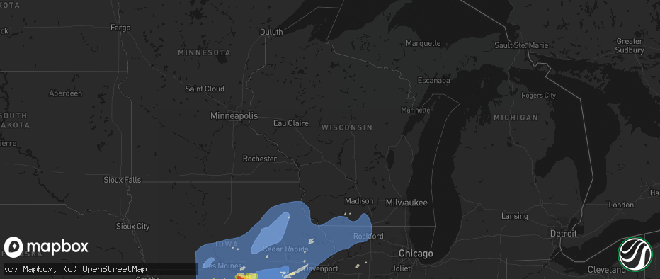
Hail Map in Wisconsin on June 11, 2026
The weather event in Wisconsin on June 11, 2026 includes Wind, Hail, and Tornado maps. 20 states and 2,417 cities were impacted and suffered possible damage. The total estimated number of properties impacted is 0.
Wind
Hail
Tornado
0
Estimated number of impacted properties by a 1.00" hail or larger0
Estimated number of impacted properties by a 1.75" hail or larger0
Estimated number of impacted properties by a 2.50" hail or largerStorm reports in Wisconsin
Wisconsin
| Date | Description |
|---|---|
| 06/11/20266:27 PM CDT | Sheboygan airport. |
| 06/11/20266:12 PM CDT | National weather service storm survey confirms a tornado rated ef-1 near somers. Brief tornado began on the south side of 18th street west of 72nd ave. Two barn outbuil |
| 06/11/20266:10 PM CDT | Touchdown near the intersection of us hwy 45 and wi hwy 142. |
| 06/11/20266:10 PM CDT | Several large branches down on 136th ave just s of hwy 142. Possible tornado. |
| 06/11/20265:35 PM CDT | Large branch down on hill st in walworth. Time est from radar. |
| 06/11/202611:15 AM CDT | Tree down near 23rd and pine street. Time estimated from radar. |
| 06/11/202611:10 AM CDT | A number of trees and limbs down in la crosse and onalaska. Time estimated from radar. |
| 06/11/202611:10 AM CDT | Tree down on two cars. Time estimated from radar. |
All States Impacted by Hail Map on June 11, 2026
Cities Impacted by Hail Map on June 11, 2026
- Shannon City, IA
- Tingley, IA
- Greenfield, IA
- Mount Ayr, IA
- Afton, IA
- Guthrie Center, IA
- Diagonal, IA
- Panora, IA
- Menlo, IA
- Bagley, IA
- Creston, IA
- Stuart, IA
- Orient, IA
- Yale, IA
- Kellerton, IA
- Dexter, IA
- Macksburg, IA
- Ellston, IA
- Grand River, IA
- Thayer, IA
- Murray, IA
- Worth, MO
- Lenox, IA
- Redding, IA
- Denver, MO
- Blockton, IA
- Benton, IA
- Grant City, MO
- Hatfield, MO
- Casey, IA
- Martinsville, MO
- Winterset, IA
- Linden, IA
- Jamaica, IA
- Rippey, IA
- Perry, IA
- Earlham, IA
- Dawson, IA
- Jefferson, IA
- Adel, IA
- Grand Junction, IA
- Redfield, IA
- Lorimor, IA
- Dallas Center, IA
- Woodward, IA
- Minburn, IA
- Ogden, IA
- Bouton, IA
- Beaver, IA
- Gentry, MO
- Albany, MO
- Unionville, MO
- Green Castle, MO
- Parnell, MO
- Bedford, IA
- Sheridan, MO
- Clearfield, IA
- Osceola, IA
- Peru, IA
- Ravenwood, MO
- Granger, IA
- Van Meter, IA
- De Soto, IA
- Luther, IA
- Boone, IA
- Waukee, IA
- Madrid, IA
- Eagleville, MO
- Booneville, IA
- Ridgeway, MO
- Bethany, MO
- Van Wert, IA
- Weldon, IA
- New Virginia, IA
- Woodburn, IA
- Lucas, IA
- Humeston, IA
- Truro, IA
- Saint Charles, IA
- Livonia, MO
- Derby, IA
- Chariton, IA
- Lacona, IA
- Leon, IA
- Grimes, IA
- Davis City, IA
- Prole, IA
- Blythedale, MO
- Urbandale, IA
- Patterson, IA
- West Des Moines, IA
- Cainsville, MO
- Lamoni, IA
- Clive, IA
- Cumming, IA
- Decatur, IA
- Johnston, IA
- Ames, IA
- Bevington, IA
- Kelley, IA
- Norwalk, IA
- Polk City, IA
- Pleasantville, IA
- Sheldahl, IA
- Runnells, IA
- Knoxville, IA
- Saint Marys, IA
- Garden Grove, IA
- Slater, IA
- Berwick, IA
- Alleman, IA
- Martensdale, IA
- Bondurant, IA
- Ackworth, IA
- Indianola, IA
- Melcher Dallas, IA
- Des Moines, IA
- Altoona, IA
- Elkhart, IA
- Lineville, IA
- Windsor Heights, IA
- Allerton, IA
- Milo, IA
- Carlisle, IA
- Cambridge, IA
- Hartford, IA
- Swan, IA
- Williamson, IA
- Liberty Center, IA
- Corydon, IA
- Pleasant Hill, IA
- Huxley, IA
- Ankeny, IA
- Columbia, IA
- Princeton, MO
- Stanberry, MO
- Conception Junction, MO
- Clyde, MO
- Moulton, IA
- Coatsville, MO
- Wildorado, TX
- Vega, TX
- Russell, IA
- Hamilton, IA
- Lovilia, IA
- Story City, IA
- Gilbert, IA
- Nevada, IA
- Monroe, IA
- Maxwell, IA
- Colfax, IA
- Mitchellville, IA
- Prairie City, IA
- Collins, IA
- Mingo, IA
- Harvey, IA
- Tracy, IA
- Bussey, IA
- Melrose, IA
- Albia, IA
- Oskaloosa, IA
- Eddyville, IA
- Leighton, IA
- Pella, IA
- Beacon, IA
- Pulaski, IA
- Douds, IA
- Bloomfield, IA
- Milton, IA
- Mercer, MO
- Clio, IA
- New Hampton, MO
- Colo, IA
- Memphis, MO
- McFall, MO
- Friona, TX
- Darlington, MO
- Saint Anthony, IA
- Newton, IA
- Baxter, IA
- State Center, IA
- Ira, IA
- McCallsburg, IA
- Zearing, IA
- Roland, IA
- Rhodes, IA
- Blakesburg, IA
- Ottumwa, IA
- University Park, IA
- New Sharon, IA
- Millerton, IA
- Promise City, IA
- Clemons, IA
- Melbourne, IA
- Union, IA
- New Providence, IA
- Albion, IA
- Marshalltown, IA
- Haverhill, IA
- Conrad, IA
- Liscomb, IA
- Laurel, IA
- Beaman, IA
- Garwin, IA
- Ferguson, IA
- Gilman, IA
- Gladbrook, IA
- Montour, IA
- Malcom, IA
- Otley, IA
- Toledo, IA
- Grinnell, IA
- Killduff, IA
- Searsboro, IA
- Kellogg, IA
- Reasnor, IA
- Sully, IA
- Le Grand, IA
- Lynnville, IA
- Tama, IA
- Cedar, IA
- Fremont, IA
- Mystic, IA
- What Cheer, IA
- Montezuma, IA
- Unionville, IA
- Chillicothe, IA
- Lucerne, MO
- Centerville, IA
- Powersville, MO
- Barnes City, IA
- Plano, IA
- Kirkville, IA
- Rose Hill, IA
- Moravia, IA
- Seymour, IA
- Brooklyn, IA
- Cincinnati, IA
- Udell, IA
- Newtown, MO
- Keosauqua, IA
- Hedrick, IA
- Birmingham, IA
- Drakesville, IA
- Exline, IA
- Pollock, MO
- Batavia, IA
- Delta, IA
- Agency, IA
- Deep River, IA
- Gibson, IA
- Eldon, IA
- Floris, IA
- Grundy Center, IA
- Lincoln, IA
- Reinbeck, IA
- Whitten, IA
- Eldora, IA
- Elberon, IA
- Chelsea, IA
- Vining, IA
- Clutier, IA
- Dysart, IA
- Traer, IA
- Buckingham, IA
- Stockport, IA
- Sigourney, IA
- Gilman City, MO
- Cedar Falls, IA
- Morrison, IA
- Hudson, IA
- Dike, IA
- Hartwick, IA
- Guernsey, IA
- Marengo, IA
- Martinsburg, IA
- Belle Plaine, IA
- Hayesville, IA
- Keswick, IA
- Webster, IA
- Victor, IA
- Harper, IA
- South English, IA
- Spickard, MO
- Keota, IA
- Jameson, MO
- Harris, MO
- Fairfield, IA
- Packwood, IA
- Ollie, IA
- Millersburg, IA
- North English, IA
- Richland, IA
- Libertyville, IA
- Williamsburg, IA
- Ladora, IA
- Janesville, IA
- Waverly, IA
- Waterloo, IA
- Keystone, IA
- New Hartford, IA
- La Porte City, IA
- Shellsburg, IA
- Van Horne, IA
- Vinton, IA
- Garrison, IA
- Mount Auburn, IA
- Evansdale, IA
- Brighton, IA
- Fairfax, IA
- Palo, IA
- Parnell, IA
- Blairstown, IA
- Norway, IA
- Wellman, IA
- Luzerne, IA
- Atkins, IA
- Jesup, IA
- Homestead, IA
- South Amana, IA
- Conroy, IA
- Middle Amana, IA
- Amana, IA
- Newhall, IA
- Gilbertville, IA
- Watkins, IA
- Swisher, IA
- Iowa City, IA
- North Liberty, IA
- Kalona, IA
- West Chester, IA
- Walford, IA
- Tiffin, IA
- Cedar Rapids, IA
- Washington, IA
- Oxford, IA
- Coralville, IA
- Riverside, IA
- Mount Pleasant, IA
- Ainsworth, IA
- Wayland, IA
- Lockridge, IA
- Olds, IA
- Crawfordsville, IA
- Columbus City, IA
- Winfield, IA
- Wapello, IA
- Mount Union, IA
- Hills, IA
- Conesville, IA
- Lone Tree, IA
- Columbus Junction, IA
- Morning Sun, IA
- Walker, IA
- Center Point, IA
- Denver, IA
- Hazleton, IA
- Brandon, IA
- Oran, IA
- Dewar, IA
- Sumner, IA
- Dunkerton, IA
- Urbana, IA
- Fairbank, IA
- Readlyn, IA
- Oelwein, IA
- Tripoli, IA
- Westgate, IA
- Raymond, IA
- Independence, IA
- Rowley, IA
- Hawkeye, IA
- Milan, MO
- Humphreys, MO
- Galt, MO
- Marion, IA
- Robins, IA
- Solon, IA
- Hiawatha, IA
- Maynard, IA
- Toddville, IA
- Green City, MO
- Yarmouth, IA
- Letts, IA
- Nichols, IA
- Muscatine, IA
- Grandview, IA
- New Boston, IL
- Moscow, IA
- West Branch, IA
- Tipton, IA
- West Liberty, IA
- Lisbon, IA
- Alburnett, IA
- Fruitland, IA
- Illinois City, IL
- Atalissa, IA
- Mount Vernon, IA
- Ely, IA
- Wilton, IA
- Farmersburg, IA
- Masonville, IA
- Dundee, IA
- Winthrop, IA
- Lamont, IA
- Randalia, IA
- Stanley, IA
- West Union, IA
- Aurora, IA
- Monona, IA
- Volga, IA
- Quasqueton, IA
- Wadena, IA
- Coggon, IA
- Fayette, IA
- Elkader, IA
- Luana, IA
- Saint Olaf, IA
- Elgin, IA
- Strawberry Point, IA
- Postville, IA
- Arlington, IA
- Clermont, IA
- Anamosa, IA
- Ryan, IA
- Olin, IA
- Monticello, IA
- Clarence, IA
- Elkport, IA
- Center Junction, IA
- Wyoming, IA
- Prairieburg, IA
- Stanwood, IA
- Bennett, IA
- Earlville, IA
- Mechanicsville, IA
- Durant, IA
- Edgewood, IA
- Delhi, IA
- Manchester, IA
- Langworthy, IA
- Martelle, IA
- Morley, IA
- Central City, IA
- Hopkinton, IA
- Springville, IA
- Delaware, IA
- Greeley, IA
- Worthington, MO
- Novinger, MO
- Glenwood, MO
- Lancaster, MO
- Monmouth, IA
- Oxford Junction, IA
- Queen City, MO
- Kirksville, MO
- Greentop, MO
- Brashear, MO
- Downing, MO
- McGregor, IA
- Garber, IA
- Guttenberg, IA
- Garnavillo, IA
- Marquette, IA
- Maquoketa, IA
- Baldwin, IA
- Glen Haven, WI
- New Vienna, IA
- Lowden, IA
- Epworth, IA
- Wheatland, IA
- Bernard, IA
- Cascade, IA
- Bagley, WI
- Farley, IA
- North Buena Vista, IA
- Holy Cross, IA
- Luxemburg, IA
- Onslow, IA
- Dyersville, IA
- Cassville, WI
- Bloomington, WI
- Colesburg, IA
- Worthington, IA
- Prairie Du Chien, WI
- New Liberty, IA
- Blue Grass, IA
- Potosi, WI
- Dubuque, IA
- La Motte, IA
- Walcott, IA
- Grand Mound, IA
- Delmar, IA
- Sherrill, IA
- Bellevue, IA
- Durango, IA
- Stockton, IA
- Zwingle, IA
- Dixon, IA
- Peosta, IA
- Calamus, IA
- Lost Nation, IA
- Oakville, IA
- Patch Grove, WI
- Baring, MO
- Hurdland, MO
- De Witt, IA
- Fulton, IL
- Davenport, IA
- Low Moor, IA
- Clinton, IA
- Andrew, IA
- Charlotte, IA
- Goose Lake, IA
- Princeton, IA
- McCausland, IA
- Eldridge, IA
- Donahue, IA
- Welton, IA
- Spragueville, IA
- Miles, IA
- Teeds Grove, IA
- Preston, IA
- Long Grove, IA
- Bryant, IA
- Camanche, IA
- East Dubuque, IL
- Elizabeth, IL
- Scales Mound, IL
- Sabula, IA
- Hanover, IL
- Savanna, IL
- Galena, IL
- Chadwick, IL
- Mount Carroll, IL
- Thomson, IL
- Morrison, IL
- Stockton, IL
- Milledgeville, IL
- Lanark, IL
- Gratiot, WI
- Pearl City, IL
- Darlington, WI
- Warren, IL
- Apple River, IL
- Cuba City, WI
- Shullsburg, WI
- Kent, IL
- Benton, WI
- Hazel Green, WI
- Lena, IL
- Keithsburg, IL
- Seaton, IL
- Mediapolis, IA
- Joy, IL
- Polo, IL
- Forreston, IL
- Shannon, IL
- Winslow, IL
- Nora, IL
- Freeport, IL
- South Wayne, WI
- Baileyville, IL
- Argyle, WI
- McConnell, IL
- Browntown, WI
- Bonaparte, IA
- Mount Sterling, IA
- Aledo, IL
- Alexis, IL
- Edina, MO
- Little York, IL
- Monroe, WI
- Cedarville, IL
- Orangeville, IL
- Dakota, IL
- Woodford, WI
- Ridott, IL
- Davis, IL
- Rock City, IL
- Brodhead, WI
- Juda, WI
- German Valley, IL
- Oregon, IL
- Byron, IL
- Mount Morris, IL
- Pecatonica, IL
- Winnebago, IL
- Durand, IL
- Leaf River, IL
- Rockford, IL
- Stillman Valley, IL
- Gorin, MO
- Donnellson, IA
- West Point, IA
- Farmington, IA
- Hillsboro, IA
- Knox City, MO
- La Belle, MO
- Rutledge, MO
- Shirland, IL
- Rockton, IL
- Janesville, WI
- Orfordville, WI
- Beloit, WI
- Evansville, WI
- Saint Paul, IA
- Kahoka, MO
- Danville, IA
- Monticello, WI
- New Glarus, WI
- Williamstown, MO
- Wyaconda, MO
- Monmouth, IL
- Blanchardville, WI
- Ohio, IL
- Princeton, IL
- South Beloit, IL
- Machesney Park, IL
- Loves Park, IL
- Roscoe, IL
- Caledonia, IL
- Footville, WI
- La Moille, IL
- Gerlaw, IL
- Rio, IL
- Galesburg, IL
- North Henderson, IL
- Viola, IL
- Oquawka, IL
- Wever, IA
- West Burlington, IA
- Burlington, IA
- Saint Patrick, MO
- Afton, WI
- Clinton, WI
- Stronghurst, IL
- Lomax, IL
- Carman, IL
- Wataga, IL
- Mendota, IL
- West Brooklyn, IL
- Gladstone, IL
- Media, IL
- Smithshire, IL
- Raritan, IL
- Roseville, IL
- Biggsville, IL
- Earlville, IL
- Oneida, IL
- Henderson, IL
- Avon, IL
- Berwick, IL
- Kirkwood, IL
- Gilson, IL
- Maquon, IL
- Saint Augustine, IL
- London Mills, IL
- Abingdon, IL
- Cameron, IL
- Altona, IL
- Knoxville, IL
- Victoria, IL
- Yates City, IL
- Elmwood, IL
- Williamsfield, IL
- Sardis, OH
- Mazon, IL
- Farmington, IL
- Trivoli, IL
- Hudson, NY
- Germantown, NY
- Elizaville, NY
- Craryville, NY
- Catskill, NY
- Trenton, MO
- Ancram, NY
- New Martinsville, WV
- Paden City, WV
- Coal City, IL
- Brimfield, IL
- Lore City, OH
- Salesville, OH
- Freeport, PA
- Leechburg, PA
- Vandergrift, PA
- Ford City, PA
- Hyde Park, PA
- Pine Plains, NY
- Peotone, IL
- Manteno, IL
- Cedar Lake, IN
- Lima, NY
- Honeoye Falls, NY
- Avon, NY
- Cordova, IL
- Quaker City, OH
- Apollo, PA
- Kittanning, PA
- Spring Church, PA
- Shelocta, PA
- Trafford, PA
- Export, PA
- Irwin, PA
- Jeannette, PA
- Murrysville, PA
- Harrison City, PA
- Claridge, PA
- Grant Park, IL
- Crown Point, IN
- Albany, IL
- Bourbonnais, IL
- Momence, IL
- Millbrook, NY
- Salt Point, NY
- Clinton Corners, NY
- Delmont, PA
- Indiana, PA
- Avonmore, PA
- Elderton, PA
- Rural Valley, PA
- Creekside, PA
- Sagamore, PA
- Home, PA
- Knox, PA
- Roxbury, CT
- Verbank, NY
- Lagrangeville, NY
- Dover Plains, NY
- Lakeside, CT
- Bethlehem, CT
- Valparaiso, IN
- Wanatah, IN
- New Alexandria, PA
- Blairsville, PA
- Black Lick, PA
- Homer City, PA
- Josephine, PA
- New Florence, PA
- Armagh, PA
- Derry, PA
- Brush Valley, PA
- Seward, PA
- Union Mills, IN
- Hanna, IN
- Pawling, NY
- Poughquag, NY
- Wingdale, NY
- Alexandria, MO
- Pittsburgh, PA
- Oakmont, PA
- Verona, PA
- New Kensington, PA
- Harwick, PA
- Springdale, PA
- Cheswick, PA
- Tarentum, PA
- Creighton, PA
- Albion, NY
- Glenville, WV
- Morgantown, WV
- Fairmont, WV
- Norborne, MO
- Kouts, IN
- Linneus, MO
- Sherman, CT
- Carrollton, MO
- Wayland, MO
- Hamilton, IL
- Warsaw, IL
- Keokuk, IA
- La Crosse, IN
- Bucklin, MO
- New Boston, MO
- Ethel, MO
- Sand Fork, WV
- Marion Center, PA
- Vintondale, PA
- Dilltown, PA
- Nanty Glo, PA
- Johnstown, PA
- Penn Run, PA
- Northern Cambria, PA
- Twin Rocks, PA
- Clymer, PA
- Belsano, PA
- Ebensburg, PA
- Strongstown, PA
- Nicktown, PA
- Heilwood, PA
- Alverda, PA
- Marsteller, PA
- Saint Benedict, PA
- Patton, PA
- Colver, PA
- Carrolltown, PA
- Elmora, PA
- Spangler, PA
- Patterson, NY
- Sublette, IL
- Sutter, IL
- West Point, IL
- Monroe, CT
- Sandy Hook, CT
- Oxford, CT
- Adrian, WV
- Buckhannon, WV
- Horner, WV
- Elmer, MO
- Carthage, IL
- Basco, IL
- Elvaston, IL
- Dixon, IL
- Reynoldsville, PA
- Du Bois, PA
- Rockton, PA
- Penfield, PA
- Chana, IL
- Brewster, NY
- New Fairfield, CT
- Gibbs, MO
- La Plata, MO
- Atlanta, MO
- Bevier, MO
- Callao, MO
- Spring Hope, NC
- Rochelle, IL
- New Cambria, MO
- Bradley, IL
- Kankakee, IL
- Rocky Mount, NC
- Pinetops, NC
- Watertown, CT
- Woodbury, CT
- Saint Anne, IL
- Elk City, KS
- Schneider, IN
- Lowell, IN
- Lake Village, IN
- Pembroke Township, IL
- Hebron, IN
- Morocco, IN
- Shelby, IN
- Demotte, IN
- Thayer, IN
- Wheatfield, IN
- Stormville, NY
- Carmel, NY
- Novelty, MO
- Cornwall Bridge, CT
- New Preston Marble Dale, CT
- Nashville, NC
- Dallas City, IL
- Tennessee, IL
- Blandinsville, IL
- La Harpe, IL
- Colchester, IL
- Independence, KS
- Neodesha, KS
- Macon, MO
- Miami, MO
- Plymouth, IL
- Bowen, IL
- Mendon, IL
- Leonard, MO
- Ursa, IL
- Cherryvale, KS
- Kent, CT
- Sharon, CT
- Middlesex, NC
- Zebulon, NC
- Edenton, NC
- Holmes, NY
- Anabel, MO
- Clarence, MO
- Okarche, OK
- Calumet, OK
- Butler, MO
- Litchfield, CT
- Slater, MO
- Castalia, NC
- Peoria, IL
- Metamora, IL
- Chillicothe, IL
- East Peoria, IL
- Mossville, IL
- Bettendorf, IA
- Sciota, IL
- Macomb, IL
- Danbury, CT
- Port Byron, IL
- Perry, OK
- Morrison, OK
- Lowpoint, IL
- Lacon, IL
- Washburn, IL
- Varna, IL
- Terra Alta, WV
- Oakland, MD
- Kitzmiller, MD
- Elk Garden, WV
- Newark, MO
- Gilliam, MO
- Glasgow, MO
- Tyner, NC
- Balmorhea, TX
- Monticello, MO
- Shelbyville, MO
- Lewistown, MO
- Ewing, MO
- Bethel, MO
- Keyser, WV
- Rawlings, MD
- Westernport, MD
- Swanton, MD
- New Creek, WV
- Burlington, WV
- Romney, WV
- Toluca, IL
- La Rose, IL
- El Reno, OK
- Dennis, KS
- Parsons, KS
- Mound Valley, KS
- Montrose, MO
- Urich, MO
- Clinton, MO
- Rushville, IL
- Vermont, IL
- Canton, MO
- Lynn Center, IL
- Clayton, IL
- Glencoe, OK
- Wenona, IL
- Lentner, MO
- Woodhull, IL
- Cambridge, IL
- Durham, MO
- La Grange, MO
- Armstrong, MO
- Augusta, IL
- Walnut, KS
- Washington Depot, CT
- New Windsor, IL
- Magnolia, IL
- Streator, IL
- Lostant, IL
- Camden, IL
- Pawnee, OK
- Industry, IL
- Shelbina, MO
- Chenoa, IL
- Gridley, IL
- Flanagan, IL
- Coffeyville, KS
- Stantonsburg, NC
- Wilson, NC
- Lewistown, IL
- Ipava, IL
- Fairview, IL
- Rutland, IL
- Lockwood, NY
- Waverly, NY
- Liberty, KS
- Altamont, KS
- Dana, IL
- Minonk, IL
- Higbee, MO
- Fayette, MO
- Battleboro, NC
- Osco, IL
- Adair, IL
- Marietta, IL
- Cuba, IL
- Ellisville, IL
- Smithfield, IL
- Pontiac, IL
- Graymont, IL
- Odell, IL
- Cornell, IL
- Littleton, IL
- Table Grove, IL
- Mount Sterling, IL
- Huntsville, IL
- Timewell, IL
- Golden, IL
- La Prairie, IL
- Barton, NY
- Ancona, IL
- Long Point, IL
- Tonica, IL
- Vinton, VA
- Goodview, VA
- Hunnewell, MO
- Emden, MO
- Canton, IL
- Hannibal, MO
- Davis Junction, IL
- Bryant, IL
- Saint David, IL
- Madison, MO
- Edna, KS
- Glasford, IL
- Astoria, IL
- Frederick, IL
- Hanna City, IL
- Browning, IL
- Sound Beach, NY
- Mount Sinai, NY
- Miller Place, NY
- Yaphank, NY
- Middle Island, NY
- Coram, NY
- Shirley, NY
- Rocky Point, NY
- Ridge, NY
- Shoreham, NY
- Medford, NY
- Maramec, OK
- Oswego, KS
- Bath, IL
- Havana, IL
- Beardstown, IL
- Liverpool, IL
- Mapleton, IL
- Topeka, IL
- Chandlerville, IL
- Manito, IL
- Kingston Mines, IL
- Pekin, IL
- Yale, OK
- Liberty, IL
- Camp Point, IL
- Lindenwood, IL
- Monroe Center, IL
- Esmond, IL
- Cherry Valley, IL
- Kirkland, IL
- Pecos, TX
- Sparland, IL
- Henry, IL
- McNabb, IL
- Hull, IL
- Burlington, WI
- Moneta, VA
- Deepwater, MO
- Colony, OK
- Easton, IL
- Kilbourne, IL
- Oakford, IL
- Monroe City, MO
- Paris, MO
- Holcomb, IL
- Kingston, IL
- Belvidere, IL
- Versailles, IL
- Dwight, IL
- Raleigh, NC
- Center, MO
- Ransom, IL
- Sturgeon, MO
- Harrisburg, MO
- Clark, MO
- Rocheport, MO
- Chambersburg, IL
- Griggsville, IL
- Bedford, VA
- Forest City, IL
- South Pekin, IL
- Tremont, IL
- Green Valley, IL
- San Jose, IL
- Delavan, IL
- Mason City, IL
- Arenzville, IL
- Virginia, IL
- Kenosha, WI
- Union Grove, WI
- Union City, OK
- Columbia, MO
- Hallsville, MO
- Thompson, MO
- Centralia, MO
- Verona, IL
- Seneca, IL
- Bartlett, KS
- Garden Prairie, IL
- Lookeba, OK
- Matador, TX
- Meredosia, IL
- Stillwater, OK
- Marengo, IL
- Galesburg, KS
- Chetopa, KS
- Sims, NC
- Saint Paul, KS
- Edwards, IL
- Louisiana, MO
- Rome, PA
- Quincy, IL
- Payson, IL
- Palmyra, MO
- Chebanse, IL
- Welch, OK
- Hinton, OK
- New London, MO
- Lenapah, OK
- S Coffeyville, OK
- Racine, WI
- Pleasant Prairie, WI
- Twin Lakes, WI
- Spring Grove, IL
- Kansasville, WI
- Bristol, WI
- Salem, WI
- Genoa City, WI
- Hebron, IL
- Wonder Lake, IL
- Richmond, IL
- Silver Lake, WI
- Sturtevant, WI
- Lake Geneva, WI
- Springfield, WI
- Elkhorn, WI
- Mexico, MO
- Harvard, IL
- Capron, IL
- Woodstock, IL
- Poplar Grove, IL
- Creve Coeur, IL
- Groveland, IL
- Washington, IL
- Morton, IL
- Jacksonville, IL
- Petersburg, IL
- Ashland, IL
- Tallula, IL
- Genoa, IL
- Hampshire, IL
- Jennings, OK
- New Canton, IL
- Rockport, IL
- Warsaw, MO
- Childress, TX
- Tell, TX
- Kinderhook, IL
- Rock Falls, IL
- Gotebo, OK
- Cordell, OK
- Wilmington, IL
- Duke, OK
- Barstow, TX
- Benton City, MO
- Martinsburg, MO
- Laddonia, MO
- Rush Hill, MO
- Deer Creek, IL
- Eureka, IL
- Essex, IL
- Braidwood, IL
- Herscher, IL
- Bonfield, IL
- Gardner, IL
- Buckingham, IL
- Reddick, IL
- Minco, OK
- Hartsburg, IL
- Emden, IL
- New Holland, IL
- Pleasant Plains, IL
- Drumright, OK
- Osceola, MO
- Pittsfield, IL
- Barry, IL
- Ochelata, OK
- Bartlesville, OK
- Barnsdall, OK
- Binger, OK
- Auxvasse, MO
- Middletown, IL
- Chapin, IL
- Concord, IL
- Perry, IL
- Jamestown, MO
- Delaware, OK
- Vinita, OK
- Carlock, IL
- Goodfield, IL
- Danvers, IL
- Lexington, IL
- Greenview, IL
- Roanoke, IL
- Hudson, IL
- Minier, IL
- Mackinaw, IL
- Stanford, IL
- Armington, IL
- Congerville, IL
- Benson, IL
- El Paso, IL
- Hopedale, IL
- Secor, IL
- Bloomington, IL
- Wapella, IL
- McLean, IL
- Lawndale, IL
- Cantrall, IL
- Waynesville, IL
- Lincoln, IL
- Sherman, IL
- Atlanta, IL
- Mount Pulaski, IL
- Kenney, IL
- Williamsville, IL
- Towanda, IL
- Clinton, IL
- Normal, IL
- Shirley, IL
- Chestnut, IL
- Elkhart, IL
- Athens, IL
- Beason, IL
- Heyworth, IL
- Springfield, IL
- Granite, OK
- Fulton, MO
- Ashland, MO
- Hartsburg, MO
- Paducah, TX
- Cushing, OK
- Gould, OK
- Fort Cobb, OK
- Martinton, IL
- Beaverville, IL
- Papineau, IL
- Miami, OK
- New Salem, IL
- Levelland, TX
- Bluffs, IL
- Winchester, IL
- Mountain View, OK
- Saint John, IN
- Dyer, IN
- Schererville, IN
- Bluejacket, OK
- Cee Vee, TX
- Anadarko, OK
- Lone Wolf, OK
- Manhattan, IL
- Alexander, IL
- New Bloomfield, MO
- Monee, IL
- Beecher, IL
- Gracemont, OK
- Floydada, TX
- Edwards, MO
- North Miami, OK
- Buffalo, IL
- Illiopolis, IL
- Riverton, IL
- Maroa, IL
- Latham, IL
- Niantic, IL
- Downs, IL
- Warrensburg, IL
- Cooksville, IL
- Decatur, IL
- De Land, IL
- Cisco, IL
- Le Roy, IL
- Hammond, IL
- Forsyth, IL
- Bement, IL
- Monticello, IL
- Farmer City, IL
- Dewitt, IL
- Colfax, IL
- Oreana, IL
- Lane, IL
- Ellsworth, IL
- Argenta, IL
- Milmine, IL
- Weldon, IL
- Arrowsmith, IL
- Cerro Gordo, IL
- Saybrook, IL
- White Heath, IL
- Forrest, IL
- Chatsworth, IL
- Fairbury, IL
- Melvin, IL
- Mansfield, IL
- Fisher, IL
- Seymour, IL
- Piper City, IL
- Danforth, IL
- Kempton, IL
- Saunemin, IL
- Ashkum, IL
- Roberts, IL
- Sibley, IL
- Cullom, IL
- Anchor, IL
- Gibson City, IL
- Mahomet, IL
- Strawn, IL
- Clifton, IL
- Foosland, IL
- Bellflower, IL
- Cropsey, IL
- Merrillville, IN
- Modesto, IL
- Unionville, VA
- Rapidan, VA
- White Hall, IL
- Roodhouse, IL
- Mangum, OK
- New Berlin, IL
- Loami, IL
- Shannon, NC
- Raeford, NC
- Griffith, IN
- Thawville, IL
- Dewey, IL
- Onarga, IL
- Paxton, IL
- Loda, IL
- Elliott, IL
- Gilman, IL
- Tolono, IL
- Sadorus, IL
- Champaign, IL
- Ivesdale, IL
- Buckley, IL
- Atwood, IL
- Bondville, IL
- Rantoul, IL
- Ludlow, IL
- Hobart, IN
- Fairland, OK
- Afton, OK
- Niota, IL
- Commerce, OK
- Mokane, MO
- Steedman, MO
- Pocasset, OK
- Morris, IL
- Virden, IL
- Waverly, IL
- Crete, IL
- Dawson, IL
- Murrayville, IL
- Chatham, IL
- Fort Madison, IA
- Roaring Springs, TX
- Rockbridge, IL
- Carrollton, IL
- Franklin, IL
- La Place, IL
- Mt Zion, IL
- Dalton City, IL
- Mount Auburn, IL
- Blue Mound, IL
- Macon, IL
- Harristown, IL
- Boody, IL
- Mechanicsburg, IL
- Edinburg, IL
- Rochester, IL
- Lovington, IL
- Wyandotte, OK
- Macatawa, MI
- Holland, MI
- West Olive, MI
- Zeeland, MI
- Hudsonville, MI
- Donovan, IL
- Crescent City, IL
- Watseka, IL
- Milford, IL
- Thomasboro, IL
- Bethany, IL
- Cissna Park, IL
- Moweaqua, IL
- Amber, OK
- Baxter Springs, KS
- Hettick, IL
- Greenfield, IL
- Portland, MO
- Rhineland, MO
- Auburn, IL
- Palmyra, IL
- Rich Hill, MO
- Williamsburg, MO
- Quapaw, OK
- Galena, KS
- Grandville, MI
- Jenison, MI
- Joplin, MO
- Bartlett, IL
- Ralls, TX
- Rankin, IL
- Gifford, IL
- Kentland, IN
- Iroquois, IL
- Sheldon, IL
- Fair Oaks, IN
- Brook, IN
- Saint Joseph, IL
- Tuscola, IL
- Wellington, IL
- Potomac, IL
- Hoopeston, IL
- Savoy, IL
- Arthur, IL
- Penfield, IL
- Urbana, IL
- Philo, IL
- Findlay, IL
- Sullivan, IL
- Pesotum, IL
- Grand Rapids, MI
- Wyoming, MI
- Byron Center, MI
- Jerseyville, IL
- Rockville, MO
- Kane, IL
- Taylorville, IL
- Roosevelt, OK
- Treece, KS
- Crosbyton, TX
- Appleton City, MO
- Kaiser, MO
- Brumley, MO
- Linn Creek, MO
- Chesterton, IN
- Quanah, TX
- Boone Grove, IN
- Caledonia, MI
- Yorkville, IL
- Lorenzo, TX
- Oswego, IL
- Romeoville, IL
- Plainfield, IL
- Bolingbrook, IL
- Naperville, IL
- Aurora, IL
- Mcadoo, TX
- Montgomery, IL
- Woodridge, IL
- Lemont, IL
- Lockport, IL
- Willowbrook, IL
- Robbins, IL
- Orland Park, IL
- Palos Heights, IL
- Willow Springs, IL
- Downers Grove, IL
- Markham, IL
- Darien, IL
- Midlothian, IL
- Crestwood, IL
- Palos Park, IL
- Lisle, IL
- Homer Glen, IL
- Oak Forest, IL
- Harvey, IL
- Posen, IL
- Blue Island, IL
- South Holland, IL
- Worth, IL
- Dolton, IL
- Alsip, IL
- Calumet City, IL
- Palos Hills, IL
- Riverdale, IL
- Brighton, IL
- Pawnee, IL
- Kincaid, IL
- Seneca, MO
- Cement, OK
- Medora, IL
- Columbus, KS
- Picher, OK
- Morrison, MO
- Warrenton, MO
- Divernon, IL
- Glenarm, IL
- Chamois, MO
- Claremore, OK
- Bridgeview, IL
- Riverside, IL
- Evergreen Park, IL
- Clarendon Hills, IL
- Oak Lawn, IL
- Westmont, IL
- Western Springs, IL
- Westchester, IL
- Hinsdale, IL
- Chicago Ridge, IL
- Broadview, IL
- Cicero, IL
- Maywood, IL
- La Grange, IL
- Berwyn, IL
- Brookfield, IL
- Forest Park, IL
- Hometown, IL
- Oak Brook, IL
- Chicago, IL
- Hickory Hills, IL
- Lyons, IL
- Justice, IL
- La Grange Park, IL
- Burbank, IL
- Summit Argo, IL
- Freeport, MI
- Wayland, MI
- Middleville, MI
- Alto, MI
- Newman, IL
- Longview, IL
- Humboldt, IL
- Armstrong, IL
- Earl Park, IN
- Broadlands, IL
- Ogden, IL
- Muncie, IL
- Charleston, IL
- Fairmount, IL
- Mattoon, IL
- Henning, IL
- Hindsboro, IL
- Oakwood, IL
- Rossville, IL
- Arcola, IL
- Murdock, IL
- Oakland, IL
- Danville, IL
- Collison, IL
- Fowler, IN
- Royal, IL
- Villa Grove, IL
- Sidney, IL
- Allerton, IL
- Fithian, IL
- Stockland, IL
- Homer, IL
- Camargo, IL
- Bismarck, IL
- Catlin, IL
- Ambia, IN
- Goodland, IN
- Reynolds, IN
- Georgetown, IL
- Tilton, IL
- Attica, IN
- Rensselaer, IN
- Indianola, IL
- Metcalf, IL
- Remington, IN
- Sidell, IL
- Brocton, IL
- Williamsport, IN
- State Line, IN
- Alvin, IL
- Monon, IN
- Oxford, IN
- Wolcott, IN
- Pine Village, IN
- Chalmers, IN
- Boswell, IN
- Westville, IL
- West Lebanon, IN
- Covington, IN
- Brookston, IN
- Hume, IL
- Mount Ayr, IN
- West Lafayette, IN
- Otterbein, IN
- Templeton, IN
- Francesville, IN
- Medaryville, IN
- North Judson, IN
- Winamac, IN
- Clarksville, MI
- Lake Odessa, MI
- Ashmore, IL
- Gary, IN
- Hammond, IN
- Whiting, IN
- East Chicago, IN
- Wright City, MO
- Crocker, MO
- Iberia, MO
- Westville, IN
- Shipman, IL
- Piasa, IL
- Fidelity, IL
- La Porte, IN
- Lawton, OK
- Ulman, MO
- Morrisonville, IL
- Palmer, IL
- Yeoman, IN
- Westpoint, IN
- Idaville, IN
- Star City, IN
- Logansport, IN
- Lafayette, IN
- Buffalo, IN
- Kewanna, IN
- Rochester, IN
- Lucerne, IN
- Ridge Farm, IL
- Delphi, IN
- Royal Center, IN
- Veedersburg, IN
- Monticello, IN
- Perrysville, IN
- Burnettsville, IN
- Cayuga, IN
- Battle Ground, IN
- Chrisman, IL
- Kansas, IL
- Sunfield, MI
- Portland, MI
- Wingate, IN
- San Pierre, IN
- Knox, IN
- Monterey, IN
- Nashville, MI
- Vermontville, MI
- Mulliken, MI
- Charlotte, MI
- Woodland, MI
- Kingman, IN
- Redmon, IL
- Dana, IN
- Paris, IL
- Grand Ledge, MI
- Grove, OK
- Dickens, TX
- Dixon, MO
- Carlinville, IL
- Gillespie, IL
- Calhoun, MO
- Chickasha, OK
- Pryor, OK
- Potterville, MI
- Eagle, MI
- Niles, MI
- Edwardsburg, MI
- Cassopolis, MI
- Mason, MI
- Williamston, MI
- Holt, MI
- Dimondale, MI
- Okemos, MI
- East Lansing, MI
- Haslett, MI
- Lansing, MI
- Dewitt, MI
- Bath, MI
- Laingsburg, MI
- Dowagiac, MI
- Walkerton, IN
- North Liberty, IN
- Mill Creek, IN
- Windsor, MO
- Medicine Park, OK
- Cyril, OK
- Fletcher, OK
- Olustee, OK
- Altus, OK
- Rockville, IN
- Plymouth, IN
- Culver, IN
- Ora, IN
- Grovertown, IN
- Hillsdale, IN
- Clinton, IN
- Argos, IN
- Newtown, IN
- Mellott, IN
- Bremen, IN
- Hillsboro, IN
- Bourbon, IN
- New Richmond, IN
- Westfield, IL
- Gays, IL
- Lerna, IL
- Windsor, IL
- Assumption, IL
- Shelbyville, IL
- Stonington, IL
- Lincoln, MO
- Sawyer, MI
- Bridgman, MI
- Portage, IN
- South Bend, IN
- Beverly Shores, IN
- Michigan City, IN
- Harbert, MI
- Three Oaks, MI
- Lakeside, MI
- Union Pier, MI
- New Buffalo, MI
- Ramsey, IL
- Oconee, IL
- Herrick, IL
- Cowden, IL
- Galien, MI
- Rolling Prairie, IN
- New Carlisle, IN
- Fort Sill, OK
- New Troy, MI
- Buchanan, MI
- Baroda, MI
- Berrien Springs, MI
- Elgin, OK
- Vermilion, IL
- Romney, IN
- Dennison, IL
- Montezuma, IN
- Waynetown, IN
- Marshall, IL
- West Terre Haute, IN
- Bloomingdale, IN
- Martinsville, IL
- Vandalia, MI
- Jones, MI
- Warsaw, IN
- Claypool, IN
- Syracuse, IN
- Linden, IN
- Crawfordsville, IN
- Flora, IN
- Camden, IN
- Buck Creek, IN
- Milford, IN
- Akron, IN
- Nappanee, IN
- Atwood, IN
- Leesburg, IN
- Twelve Mile, IN
- Mentone, IN
- Marshall, IN
- Etna Green, IN
- Macy, IN
- Dayton, IN
- Tippecanoe, IN
- Universal, IN
- Roachdale, IN
- Greencastle, IN
- Mulberry, IN
- Young America, IN
- Bringhurst, IN
- Bridgeton, IN
- Denver, IN
- Mecca, IN
- Frankfort, IN
- Reelsville, IN
- Kokomo, IN
- Peru, IN
- Ladoga, IN
- Rosedale, IN
- Galveston, IN
- New Waverly, IN
- Rossville, IN
- Darlington, IN
- Burlington, IN
- Russellville, IN
- Cutler, IN
- Alamo, IN
- Walton, IN
- Terre Haute, IN
- New Market, IN
- Silver Lake, IN
- Waveland, IN
- New Goshen, IN
- Bainbridge, IN
- Brazil, IN
- Clarks Hill, IN
- Thorntown, IN
- Jamestown, IN
- Burket, IN
- Russiaville, IN
- Carbon, IN
- Colfax, IN
- New Ross, IN
- Onward, IN
- Mexico, IN
- Advance, IN
- Michigantown, IN
- Lebanon, IN
- Roann, IN
- Forest, IN
- North Salem, IN
- Pierceton, IN
- Miami, IN
- Fairmount, IN
- Amboy, IN
- North Manchester, IN
- Sheridan, IN
- Windfall, IN
- Sharpsville, IN
- La Fontaine, IN
- Elwood, IN
- Urbana, IN
- Marion, IN
- Kirklin, IN
- Winona Lake, IN
- Goldsmith, IN
- Converse, IN
- Wabash, IN
- Swayzee, IN
- Laketon, IN
- Greentown, IN
- Bunker Hill, IN
- Tipton, IN
- Grissom Arb, IN
- Kempton, IN
- Carmel, IN
- Atlanta, IN
- Lizton, IN
- Sweetser, IN
- Lagro, IN
- Cicero, IN
- Frankton, IN
- Lapel, IN
- Noblesville, IN
- Alexandria, IN
- Zionsville, IN
- Summitville, IN
- Brownsburg, IN
- Jonesboro, IN
- Whitestown, IN
- Anderson, IN
- Westfield, IN
- Pittsboro, IN
- Arcadia, IN
- Geronimo, OK
- Jasper, MO
- Oronogo, MO
- Spur, TX
- Lanagan, MO
- Noel, MO
- South West City, MO
- Salina, OK
- Headrick, OK
- Altus Afb, OK
- Anderson, MO
- Mishawaka, IN
- Beecher City, IL
- Ballwin, MO
- Goshen, IN
- Liberty Mills, IN
- Servia, IN
- Millersburg, IN
- Middlebury, IN
- New Paris, IN
- Cromwell, IN
- Larwill, IN
- North Webster, IN
- Walters, OK
- Columbia City, IN
- Ligonier, IN
- Kimmell, IN
- Huntington, IN
- South Whitley, IN
- Van Buren, IN
- Fowlerton, IN
- Gas City, IN
- Roanoke, IN
- Andrews, IN
- Warren, IN
- Upland, IN
- Matthews, IN
- Gaston, IN
- Hartford City, IN
- Markle, IN
- Daleville, IN
- Yorktown, IN
- Muncie, IN
- Middletown, IN
- Albion, IN
- Montpelier, IN
- Effingham, IL
- Shumway, IL
- Eaton, IN
- Bluffton, IN
- Poneto, IN
- Pennville, IN
- Keystone, IN
- Dunkirk, IN
- Liberty Center, IN
- Valley Park, MO
- Shipshewana, IN
- Topeka, IN
- Lagrange, IN
- Wawaka, IN
- Uniondale, IN
- Ossian, IN
- Yoder, IN
- Zanesville, IN
- Petroleum, IN
- Bryant, IN
- Casey, IL
- Webberville, MI
- Howell, MI
- Corunna, MI
- Gaines, MI
- Swartz Creek, MI
- Lennon, MI
- Bancroft, MI
- Linden, MI
- Byron, MI
- Vernon, MI
- Fowlerville, MI
- Owosso, MI
- Morrice, MI
- Durand, MI
- Perry, MI
- Elkhart, IN
- Rome City, IN
- Wolcottville, IN
- Howe, IN
- Kendallville, IN
- Bristol, IN
- Labadie, MO
- Saint Louis, MO
- White Pigeon, MI
- Constantine, MI
- Three Rivers, MI
- Centreville, MI
- Sturgis, MI
- Carthage, MO
- Lubbock, TX
- Fenton, MO
- Camby, IN
- Greenfield, IN
- Stilesville, IN
- New Palestine, IN
- Fillmore, IN
- Mooresville, IN
- Mccordsville, IN
- Greenwood, IN
- Ingalls, IN
- Coatesville, IN
- Danville, IN
- Amo, IN
- Clayton, IN
- Fortville, IN
- Plainfield, IN
- Wilkinson, IN
- Markleville, IN
- Pendleton, IN
- West Newton, IN
- Beech Grove, IN
- Fishers, IN
- Avon, IN
- Indianapolis, IN
- Maxwell, IN
- Avilla, IN
- Golden City, MO
- Sigel, IL
- Duncan, OK
- Comanche, OK
- Rose, OK
- Tipton, OK
- Bella Vista, AR
- Sulphur Springs, AR
- Idalou, TX
- Loveland, OK
- Chattanooga, OK
- Cache, OK
- Scammon, KS
- Ashley, IN
- Burr Oak, MI
- Angola, IN
- Corunna, IN
- Waterloo, IN
- Hudson, IN
- Orland, IN
- Auburn, IN
- Pleasant Lake, IN
- South Milford, IN
- Fountaintown, IN
- Fairland, IN
- Albany, IN
- Springport, IN
- Mays, IN
- Straughn, IN
- Falmouth, IN
- Arlington, IN
- Monroe, IN
- Selma, IN
- Parker City, IN
- Mooreland, IN
- Morristown, IN
- Spiceland, IN
- Charlottesville, IN
- Fort Wayne, IN
- New Castle, IN
- Craigville, IN
- Ridgeville, IN
- Decatur, IN
- Gwynneville, IN
- Shirley, IN
- Carthage, IN
- Losantville, IN
- Redkey, IN
- Farmland, IN
- Kennard, IN
- Shelbyville, IN
- Portland, IN
- Berne, IN
- Lewisville, IN
- Knightstown, IN
- Rushville, IN
- Geneva, IN
- Robertsville, MO
- Pacific, MO
- Catawissa, MO
- Wildwood, MO
- Cedar Hill, MO
- East Carondelet, IL
- Strang, OK
- Slaton, TX
- Chouteau, OK
- Locust Grove, OK
- Colcord, OK
- Faxon, OK
- Dupo, IL
- Spavinaw, OK
- Hastings, OK
- Waurika, OK
- Temple, OK
- Hoagland, IN
- New Haven, IN
- Monroeville, IN
- Woodburn, IN
- Ansonia, OH
- Paulding, OH
- Modoc, IN
- Wren, OH
- Saint Henry, OH
- Celina, OH
- Lynn, IN
- Rockford, OH
- Fort Recovery, OH
- Convoy, OH
- Rossburg, OH
- Spencerville, OH
- Milton, IN
- Saint Marys, OH
- Union City, OH
- Cambridge City, IN
- Coldwater, OH
- Maria Stein, OH
- Richmond, IN
- Fountain City, IN
- Montezuma, OH
- Economy, IN
- Payne, OH
- Haviland, OH
- Hagerstown, IN
- Mendon, OH
- Saratoga, IN
- Connersville, IN
- Delphos, OH
- Van Wert, OH
- Salamonia, IN
- Willshire, OH
- Union City, IN
- Winchester, IN
- Centerville, IN
- Scott, OH
- Williamsburg, IN
- Antwerp, OH
- Venedocia, OH
- Greens Fork, IN
- New Weston, OH
- Burkettsville, OH
- Grover Hill, OH
- Ohio City, OH
- Middle Point, OH
- Pioneer, OH
- Montgomery, MI
- Camden, MI
- Montpelier, OH
- Coldwater, MI
- Bronson, MI
- Fremont, IN
- Bryan, OH
- Edgerton, OH
- Hamilton, IN
- West Unity, OH
- Butler, IN
- Reading, MI
- Quincy, MI
- Edon, OH
- Post, TX
- Belleville, IL
- Millstadt, IL
- Kansas, OK
- High Ridge, MO
- Bentonville, AR
- Arcanum, OH
- Versailles, OH
- Boston, IN
- Webster, IN
- New Madison, OH
- Brownsville, IN
- Yorkshire, OH
- West Manchester, OH
- Hollansburg, OH
- Eaton, OH
- Camden, OH
- Palestine, OH
- New Bremen, OH
- College Corner, OH
- New Paris, OH
- Liberty, IN
- Greenville, OH
- Chickasaw, OH
- Eldorado, OH
- Fort Jennings, OH
- Randlett, OK
- Wilson, TX
- Tahoka, TX
- Hulbert, OK
- Cloverdale, OH
- Ottoville, OH
- Columbus Grove, OH
- Ottawa, OH
- Lima, OH
- Kalida, OH
- Fayette, OH
- Hillsdale, MI
- Alvordton, OH
- Morenci, MI
- Osseo, MI
- Pittsford, MI
- Archbold, OH
- Waldron, MI
- Hudson, MI
- Allen, MI
- Pineville, MO
- Columbia, IL
- Wagoner, OK
- Lyons, OH
- Adrian, MI
- Jasper, MI
- Clayton, MI
- Stryker, OH
- Tecumseh, MI
- Sand Creek, MI
- Wauseon, OH
- Manitou Beach, MI
- Tipton, MI
- Onsted, MI
- Addison, MI
- North Adams, MI
- Watts, OK
- Wichita Falls, TX
- Jonesville, MI
- Cement City, MI
- Jerome, MI
- Brooklyn, MI
- Tahlequah, OK
- Aldrich, MO
- Bolivar, MO
- Fair Play, MO
- Metamora, OH
- Riga, MI
- Ottawa Lake, MI
- Swanton, OH
- Milan, MI
- Clinton, MI
- Berkey, OH
- Manchester, MI
- Palmyra, MI
- Blissfield, MI
- Delta, OH
- Britton, MI
- Saline, MI
- Deerfield, MI
- Troy, OH
- Pitsburg, OH
- Bluffton, OH
- Harrod, OH
- Cairo, OH
- Houston, OH
- Anna, OH
- Brookville, OH
- Lafayette, OH
- Botkins, OH
- New Hampshire, OH
- Tipp City, OH
- Russia, OH
- Wapakoneta, OH
- Vandalia, OH
- Gomer, OH
- Jackson Center, OH
- Dayton, OH
- De Graff, OH
- Sidney, OH
- Piqua, OH
- Phillipsburg, OH
- Minster, OH
- Buckland, OH
- Waynesfield, OH
- Lakeview, OH
- West Alexandria, OH
- Covington, OH
- West Milton, OH
- Vaughnsville, OH
- New Lebanon, OH
- Quincy, OH
- Ludlow Falls, OH
- Fletcher, OH
- Uniopolis, OH
- Beaverdam, OH
- Farmersville, OH
- Englewood, OH
- Laura, OH
- Pleasant Hill, OH
- Fort Loramie, OH
- Osgood, OH
- New Knoxville, OH
- Clayton, OH
- Bradford, OH
- Pandora, OH
- Maplewood, OH
- Pemberton, OH
- Lewistown, OH
- Verona, OH
- Lewisburg, OH
- Gettysburg, OH
- Port Jefferson, OH
- Mount Cory, OH
- Findlay, OH
- McComb, OH
- Benton Ridge, OH
- Rawson, OH
- Odonnell, TX
- Reeds, MO
- Summers, AR
- Alger, OH
- Jenera, OH
- Ada, OH
- Arlington, OH
- Forest, OH
- Welling, OK
- Sainte Genevieve, MO
- Duenweg, MO
- Holliday, TX
- Muskogee, OK
- Fort Gibson, OK
- Siloam Springs, AR
- Cisne, IL
- Mount Erie, IL
- Scotland, TX
- McCutchenville, OH
- Fostoria, OH
- Arcadia, OH
- Carey, OH
- Tiffin, OH
- Vanlue, OH
- New Riegel, OH
- Upper Sandusky, OH
- Mount Blanchard, OH
- Alvada, OH
- Sycamore, OH
- Perryville, MO
- Saint Mary, MO
- Lamesa, TX
- Park Hill, OK
- Bunch, OK
- Stilwell, OK
- Proctor, OK
- Bloomville, OH
- Republic, OH
- Braggs, OK
- Maybee, MI
- Dundee, MI
- Petersburg, MI
- Webbers Falls, OK
- Gore, OK
- Frohna, MO
- Farrar, MO
- Vian, OK
- Ellington, MO
- Checotah, OK
- Porum, OK
- Stigler, OK
- Van Buren, MO
- Grandin, MO
- Ellsinore, MO
- Marion, KY
- Owensboro, KY
- Smithville, OK
- Doniphan, MO
- Mcalester, OK
- Beaver Dam, KY
- Cromwell, KY
- Harviell, MO
- Oxly, MO
- Naylor, MO
- Broken Bow, OK
- Horse Branch, KY
- Murray, KY
- Hayti, MO
- Bragg City, MO
- Greensburg, KY
- Whitefield, OK
- Andrews Air Force Base, MD
- Huntly, VA
- Linden, VA
- Washington, DC
- Reston, VA
- Delaplane, VA
- Fort Washington, MD
- Vienna, VA
- Hume, VA
- Ashburn, VA
- Leesburg, VA
- Dunkirk, MD
- Churchton, MD
- Middleburg, VA
- West River, MD
- Friendship, MD
- Chester Gap, VA
- The Plains, VA
- Fairfax, VA
- Naval Anacost Annex, DC
- Oakton, VA
- Haymarket, VA
- Centreville, VA
- Catharpin, VA
- Lanham, MD
- Arlington, VA
- McLean, VA
- Lothian, MD
- Alexandria, VA
- Chantilly, VA
- Front Royal, VA
- Markham, VA
- Hyattsville, MD
- Shady Side, MD
- Harwood, MD
- Capitol Heights, MD
- Falls Church, VA
- Tracys Landing, MD
- Bowie, MD
- Deale, MD
- Clinton, MD
- Upper Marlboro, MD
- Brentwood, MD
- Sterling, VA
- District Heights, MD
- Marshall, VA
- Owings, MD
- Galesville, MD
- Davidsonville, MD
- Bethesda, MD
- Herndon, VA
- Upperville, VA
- Suitland, MD
- Oxon Hill, MD
- Annandale, VA
- Temple Hills, MD
- Edgewater, MD
- Mount Rainier, MD
- Dunn Loring, VA
- Aldie, VA
- Fort Myer, VA
- Springfield, VA
- Gambrills, MD
- Crownsville, MD
- Riva, MD
- Stevensville, MD
- Annapolis, MD
- Carmichaels, PA
- Algonac, MI
- Clinton Township, MI
- Harsens Island, MI
- Harper Woods, MI
- Harrison Township, MI
- Saint Clair Shores, MI
- Eastpointe, MI
- Sterling Heights, MI
- New Baltimore, MI
- Fair Haven, MI
- Marine City, MI
- Roseville, MI
- Macomb, MI
- Warren, MI
- Grosse Pointe, MI
- Fraser, MI
- Detroit, MI
- Mount Clemens, MI
- Union, MI
- Berrien Center, MI
- Granger, IN
- Osceola, IN
- Kingsford Heights, IN
- Notre Dame, IN
- Lakeville, IN
- Hamlet, IN
- Taylor Ridge, IL
- Montpelier, IA
- Andalusia, IL
- Buffalo, IA
- Le Claire, IA


