Hail Map in Canyon, TX on August 18, 2015
The weather event in Canyon, TX on August 18, 2015 includes Hail map. 20 states and 395 cities were impacted and suffered possible damage. The total estimated number of properties impacted is 2.
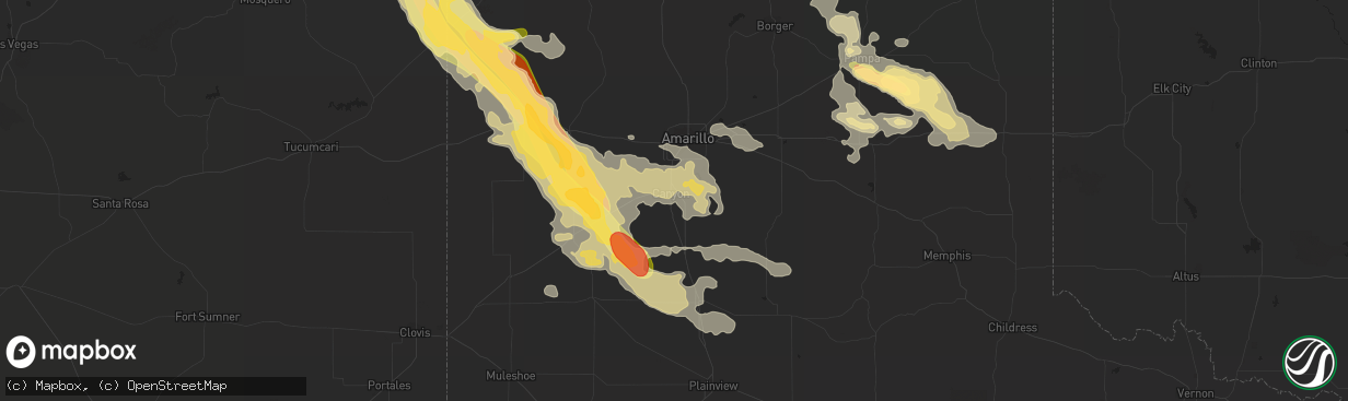
Hail
2
Estimated number of impacted properties by a 1.00" hail or larger2
Estimated number of impacted properties by a 1.75" hail or larger0
Estimated number of impacted properties by a 2.50" hail or largerStorm reports in Canyon, TX
Canyon, TX
| Date | Description |
|---|---|
| 08/18/20152:15 AM CDT | A local report indicates 59 MPH wind near 3 NNE UMBARGER |
| 08/18/20152:15 AM CDT | Measured 58 mph thunderstorm wind gust. Tree blown down facing southwest direction and several two to three inch diameter tree branches broken off. |
| 08/18/20152:12 AM CDT | A local report indicates 64 MPH wind near 3 NNE UMBARGER |
| 08/18/20152:10 AM CDT | An empty tractor trailer was blown up on top of a 10 foot stack of equipment and was resting on its side. Power is out and there is quite a bit of fence damage. Also... |
| 08/18/20152:07 AM CDT | Numerous large tree limbs up to 8 diameter snapped at camp don harrington. |
| 08/18/20152:05 AM CDT | Power poles down just east of canyon.. Trees blown down just north of canyon. An rv trailer was flipped over just north of canyon as well. |
| 08/18/20152:04 AM CDT | A local report indicates 58 MPH wind near CANYON |
| 08/18/20151:55 AM CDT | Large trees blown down. Damage to stables and fences. |
| 08/18/20151:55 AM CDT | Power poles snapped... Barn destroyed... Fifth wheel rv blown over and a horse trailer pushed into a truck. Just southeast of interstate 27 and rockwell road. Time esti |
| 08/18/20151:55 AM CDT | Windows blown out of at least 18 vehicles. Gravel and debris in vehicles. Time estimated by radar. |
| 08/18/20151:50 AM CDT | Roof was ripped off of an empty mobile home. |
All States Impacted by Hail Map on August 18, 2015
All Cities Impacted by Hail Map on August 18, 2015
- Prattsburgh, NY
- Tulia, TX
- Kress, TX
- Hereford, TX
- Panhandle, TX
- Adrian, TX
- Vega, TX
- Silverton, TX
- Happy, TX
- Channing, TX
- Erick, OK
- Texola, OK
- Fairfax, OK
- Burbank, OK
- Ponca City, OK
- Higgins, TX
- Mosquero, NM
- Roy, NM
- Pampa, TX
- Canadian, TX
- Miami, TX
- Wellington, TX
- Shamrock, TX
- Muleshoe, TX
- Dimmitt, TX
- Canton, IL
- Farmington, IL
- Hennessey, OK
- Warrensburg, MO
- Bonne Terre, MO
- Buffalo, KS
- Mayetta, KS
- Holton, KS
- Soldier, KS
- Capulin, NM
- Des Moines, NM
- Groom, TX
- Independence, MO
- Amistad, NM
- Seiling, OK
- Taloga, OK
- Brooksville, FL
- Shidler, OK
- Garnett, KS
- Richmond, KS
- Childress, TX
- Brighton, IL
- East Palatka, FL
- Folsom, NM
- Logan, NM
- Nara Visa, NM
- Dalhart, TX
- Grenville, NM
- Clayton, NM
- Wildorado, TX
- Raton, NM
- Canyon, TX
- Nazareth, TX
- Amarillo, TX
- Mount Olive, IL
- Jamestown, MO
- Hartsburg, MO
- Billings, OK
- Perry, OK
- Red Rock, OK
- Oak Grove, MO
- Buckner, MO
- Grain Valley, MO
- Blue Springs, MO
- Lees Summit, MO
- Kansas City, MO
- Mclean, TX
- Marionville, MO
- Suwanee, GA
- Dacula, GA
- Buford, GA
- Lawrenceville, GA
- Fall River, KS
- Butler, OK
- Clinton, OK
- Edgar, NE
- Ong, NE
- Beebe, AR
- Waukomis, OK
- Fairview, OK
- Mayview, MO
- Lexington, MO
- Ellington, MO
- Centerville, MO
- Knob Noster, MO
- Severy, KS
- Fredonia, KS
- California, MO
- Fayette, AL
- Lenapah, OK
- Reydon, OK
- Overbrook, KS
- Lawrence, KS
- Booker, TX
- Lipscomb, TX
- McCune, KS
- Mulhall, OK
- Hart, TX
- Hydro, OK
- Cedar Vale, KS
- Napoleon, MO
- Sibley, MO
- Howard, KS
- Moline, KS
- Niotaze, KS
- Grenola, KS
- Sedan, KS
- Havana, KS
- Elk Falls, KS
- Peru, KS
- Longton, KS
- Elk City, KS
- Wann, OK
- Cordell, OK
- Windsor, MO
- Register, GA
- Spooner, WI
- Trego, WI
- Springbrook, WI
- Corn, OK
- Green Ridge, MO
- Ralston, OK
- Marland, OK
- Blue Mound, KS
- Centerville, KS
- Mound City, KS
- Corydon, KY
- Savanna, IL
- Houlka, MS
- Okolona, MS
- Astoria, IL
- Ames, OK
- Borger, TX
- Westmoreland, KS
- Van Horn, TX
- Alamogordo, NM
- Cherryvale, KS
- Independence, KS
- Garber, OK
- Wheeler, TX
- Briscoe, TX
- Hoyt, KS
- Havensville, KS
- Denison, KS
- Onaga, KS
- Marshall, OK
- Turkey, TX
- Shrewsbury, MA
- Boylston, MA
- Otterville, MO
- Syracuse, MO
- Florence, MO
- Kingfisher, OK
- Woodward, OK
- Godfrey, IL
- Wayside, TX
- Enid, OK
- De Witt, IA
- Roseville, IL
- Good Hope, IL
- Benedict, KS
- Eureka, KS
- Toronto, KS
- Claude, TX
- Yulee, FL
- Callahan, FL
- Perryton, TX
- Rushville, IL
- Ringwood, OK
- Brunswick, GA
- Jersey Shore, PA
- Cogan Station, PA
- Linden, PA
- Liberty, IL
- Payson, IL
- Quincy, IL
- Brussels, IL
- Sharon, OK
- Bolton, MA
- Berlin, MA
- Oak Ridge, MO
- Jackson, MO
- Canton, OK
- Watonga, OK
- Sweetwater, OK
- Thayer, KS
- Altoona, KS
- Neodesha, KS
- Sayre, OK
- Willow, OK
- Spearman, TX
- Oakwood, OK
- Higginsville, MO
- Tipton, MO
- Smithland, KY
- Hampton, KY
- Newnan, GA
- Cleo Springs, OK
- Barker, NY
- Appleton, NY
- Hedley, TX
- Lelia Lake, TX
- Shawnee, KS
- Stoutsville, MO
- Montgomery, AL
- Delia, KS
- Caney, KS
- Coffeyville, KS
- Pomona Park, FL
- Oswego, KS
- White Deer, TX
- Vici, OK
- Palo, IA
- Versailles, MO
- Maxwell, NE
- Curtis, NE
- Bunceton, MO
- Dow, IL
- Grafton, IL
- Balko, OK
- Goose Lake, IA
- Charlotte, IA
- Millersville, MO
- Union Springs, AL
- Fort Davis, AL
- Tuskegee, AL
- Friona, TX
- Ashland, MO
- Billings, MO
- Prairie, MS
- Aberdeen, MS
- Auburn, GA
- Flomot, TX
- Mission, KS
- Kansas City, KS
- Marquand, MO
- Patton, MO
- Gould, OK
- Odessa, MO
- Holden, MO
- Centerview, MO
- Troy, MO
- Old Monroe, MO
- Winfield, MO
- Moscow Mills, MO
- Kingsville, MO
- Pleasant Hill, MO
- Bates City, MO
- Lone Jack, MO
- Durham, OK
- Romeoville, IL
- Bolingbrook, IL
- Avoca, NY
- Marion, AL
- Carbondale, KS
- Wakarusa, KS
- Berryton, KS
- Hope Hull, AL
- Welch, OK
- Clarksburg, MO
- Mangum, OK
- Quapaw, OK
- Miami, OK
- Pawnee, OK
- West Alton, MO
- Elsah, IL
- Bethalto, IL
- Moro, IL
- Dorsey, IL
- Baxter Springs, KS
- Stover, MO
- Mound Valley, KS
- Fredericktown, MO
- Houston, MS
- Chester, OK
- Cole Camp, MO
- Mora, MO
- Blair, OK
- Woodland, MS
- West Point, MS
- Dequincy, LA
- Topeka, KS
- Silver Lake, KS
- Douglas, OK
- Bison, OK
- Piedmont, KS
- Bluejacket, OK
- Alton, IL
- Butler, AL
- Dodson, TX
- Longdale, OK
- Sedalia, MO
- Greenwood, MO
- Raymore, MO
- Bunker Hill, IL
- Crest Hill, IL
- Lockport, IL
- Joliet, IL
- Plainfield, IL
- Mutual, OK
- Wyandotte, OK
- Jacksonville, FL
- Seneca, MO
- Neosho, MO
- Burt, NY
- Lockport, NY
- Newfane, NY
- Bessie, OK
- Altamont, KS
- Valley Falls, KS
- Hollis, OK
- Vinson, OK
- Sierra Blanca, TX
- Brewerton, NY
- Clay, NY
- Warrenton, MO
- Duluth, GA
- Cumming, GA
- Alpharetta, GA
- Guyton, GA
- Kinderhook, IL
- Barry, IL
- Irondale, MO
- Park Hills, MO
- Mineral Point, MO
- Ottawa, KS
- Baldwinsville, NY
- Smithton, MO
- Lockney, TX
- Bryant, IL
- Cuba, IL
- Lewistown, IL
- Arcadia, MO
- Ironton, MO
- Ward, AR
- Calamus, IA
- Owasso, OK
- Sperry, OK
- Millbrook, AL
- Wright City, MO
- Parsons, KS
- Galesburg, KS
- Lecompton, KS
- Northborough, MA
- Schell City, MO
- Newburgh, NY
- Mount Carroll, IL
- Stockton, IL
- Elizabeth, IL
- Blackwell, OK
- Vermont, IL
- Townsend, GA
- Edna, KS
- Dearing, KS
- Tyro, KS
- S Coffeyville, OK
- Liberty, KS
- Copan, OK
- Dennis, KS
- Clinton, MA
- Lancaster, MA
- Delaware, OK
- Clarendon, TX
- Pleasanton, KS
- Avon, IL
- Berwick, IL
- Pekin, IL
- Hyde Park, NY
- Kent, IL
- Pearl City, IL
- Vinita, OK
- Fairmont, OK
- Norris, IL
- Kaw City, OK
- Tonkawa, OK
- Blackwater, MO
- Browning, IL
- Ipava, IL
- Mapleton, IL
- Peoria, IL
- Grandview, MO
- Foss, OK
- Perryville, MO
- Junction City, KS
- Canandaigua, NY
- Crescent, OK
- Trivoli, IL
- Elmwood, IL
- Baldwin City, KS
- Hoschton, GA


