Hail Map in Illinois on August 18, 2015
The weather event in Illinois on August 18, 2015 includes Hail map. 20 states and 395 cities were impacted and suffered possible damage. The total estimated number of properties impacted is 251.
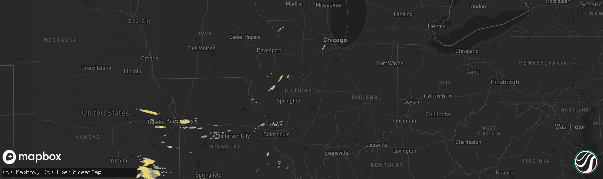
Hail
251
Estimated number of impacted properties by a 1.00" hail or larger0
Estimated number of impacted properties by a 1.75" hail or larger0
Estimated number of impacted properties by a 2.50" hail or largerStorm reports in Illinois
Illinois
| Date | Description |
|---|---|
| 08/18/20156:12 PM CDT | 4 to 6 inch diameter tree branches blown down in congerville |
| 08/18/20156:09 PM CDT | Delayed report. Weak tornado damaged pine trees... Downed tree limbs onto three homes... And damaged crops in a path 50 to 75 yards wide for 2 miles. Tornado dissipated in (i |
| 08/18/20155:55 PM CDT | Power line blown down on oak street in hopedale. |
| 08/18/20155:53 PM CDT | 45 by 50 foot pole barn under construction was blown over |
| 08/18/20155:40 PM CDT | A mesonet station near mccluggage bridge and us-24/150 measured a 59 mph gust. |
| 08/18/20155:24 PM CDT | Estimated 50-60 mph wind gusts bending trees over on i-74 near exit 82...no damage noted at this time...swop report |
| 08/18/20155:13 PM CDT | Trained spotter reported tree damage near eden and route 8...relayed by emergency manager |
| 08/18/20155:10 PM CDT | Relayed by state police. Location estimated from radar. |
| 08/18/20155:05 PM CDT | 5 miles s of pontiac or 2 miles north of chenoa. Just west of i-55. Brief ef-0 touchdown with no damage observed. |
| 08/18/20154:56 PM CDT | A local report indicates 1.00 inch wind near 2 S FARMINGTON |
| 08/18/20154:32 PM CDT | Brief touchdown. Ef-0 tornado with no damage observed. |
| 08/17/20158:06 PM CDT | Brief...weak ef-0 tornado with maximum winds of 65-70 mph...path length of 0.25 miles and path width of 50-75 yards. A few hardwood trees snapped...one snapped a powerp |
| 08/17/20158:05 PM CDT | Several 2-4 inch branches down and 18-20 inch tree top snapped off in green valley forest preserve. Time estimated. |
| 08/17/20157:55 PM CDT | Ef-0 tornado with maximum winds of 70-80 mph...path length of 3.01 miles and path width of 50-75 yards tracked from extreme southeast naperville to eastern woodridge. S |
| 08/17/20157:45 PM CDT | 5-inch tree limbs were blown down |
| 08/17/20157:32 PM CDT | At gardner fire department. |
| 08/17/20157:30 PM CDT | Delayed report. Roof off of garage in central city neighborhood between braceville and coal city. Also small tree limbs and powerlines down in area. Report relayed via |
| 08/17/20157:00 PM CDT | About 7 trees damaged in the sandrock subdivision. Trees and large limbs down...one vehicle was damaged by a downed tree |
All States Impacted by Hail Map on August 18, 2015
Cities Impacted by Hail Map on August 18, 2015
- Prattsburgh, NY
- Tulia, TX
- Kress, TX
- Hereford, TX
- Panhandle, TX
- Adrian, TX
- Vega, TX
- Silverton, TX
- Happy, TX
- Channing, TX
- Erick, OK
- Texola, OK
- Fairfax, OK
- Burbank, OK
- Ponca City, OK
- Higgins, TX
- Mosquero, NM
- Roy, NM
- Pampa, TX
- Canadian, TX
- Miami, TX
- Wellington, TX
- Shamrock, TX
- Muleshoe, TX
- Dimmitt, TX
- Canton, IL
- Farmington, IL
- Hennessey, OK
- Warrensburg, MO
- Bonne Terre, MO
- Buffalo, KS
- Mayetta, KS
- Holton, KS
- Soldier, KS
- Capulin, NM
- Des Moines, NM
- Groom, TX
- Independence, MO
- Amistad, NM
- Seiling, OK
- Taloga, OK
- Brooksville, FL
- Shidler, OK
- Garnett, KS
- Richmond, KS
- Childress, TX
- Brighton, IL
- East Palatka, FL
- Folsom, NM
- Logan, NM
- Nara Visa, NM
- Dalhart, TX
- Grenville, NM
- Clayton, NM
- Wildorado, TX
- Raton, NM
- Canyon, TX
- Nazareth, TX
- Amarillo, TX
- Mount Olive, IL
- Jamestown, MO
- Hartsburg, MO
- Billings, OK
- Perry, OK
- Red Rock, OK
- Oak Grove, MO
- Buckner, MO
- Grain Valley, MO
- Blue Springs, MO
- Lees Summit, MO
- Kansas City, MO
- Mclean, TX
- Marionville, MO
- Suwanee, GA
- Dacula, GA
- Buford, GA
- Lawrenceville, GA
- Fall River, KS
- Butler, OK
- Clinton, OK
- Edgar, NE
- Ong, NE
- Beebe, AR
- Waukomis, OK
- Fairview, OK
- Mayview, MO
- Lexington, MO
- Ellington, MO
- Centerville, MO
- Knob Noster, MO
- Severy, KS
- Fredonia, KS
- California, MO
- Fayette, AL
- Lenapah, OK
- Reydon, OK
- Overbrook, KS
- Lawrence, KS
- Booker, TX
- Lipscomb, TX
- McCune, KS
- Mulhall, OK
- Hart, TX
- Hydro, OK
- Cedar Vale, KS
- Napoleon, MO
- Sibley, MO
- Howard, KS
- Moline, KS
- Niotaze, KS
- Grenola, KS
- Sedan, KS
- Havana, KS
- Elk Falls, KS
- Peru, KS
- Longton, KS
- Elk City, KS
- Wann, OK
- Cordell, OK
- Windsor, MO
- Register, GA
- Spooner, WI
- Trego, WI
- Springbrook, WI
- Corn, OK
- Green Ridge, MO
- Ralston, OK
- Marland, OK
- Blue Mound, KS
- Centerville, KS
- Mound City, KS
- Corydon, KY
- Savanna, IL
- Houlka, MS
- Okolona, MS
- Astoria, IL
- Ames, OK
- Borger, TX
- Westmoreland, KS
- Van Horn, TX
- Alamogordo, NM
- Cherryvale, KS
- Independence, KS
- Garber, OK
- Wheeler, TX
- Briscoe, TX
- Hoyt, KS
- Havensville, KS
- Denison, KS
- Onaga, KS
- Marshall, OK
- Turkey, TX
- Shrewsbury, MA
- Boylston, MA
- Otterville, MO
- Syracuse, MO
- Florence, MO
- Kingfisher, OK
- Woodward, OK
- Godfrey, IL
- Wayside, TX
- Enid, OK
- De Witt, IA
- Roseville, IL
- Good Hope, IL
- Benedict, KS
- Eureka, KS
- Toronto, KS
- Claude, TX
- Yulee, FL
- Callahan, FL
- Perryton, TX
- Rushville, IL
- Ringwood, OK
- Brunswick, GA
- Jersey Shore, PA
- Cogan Station, PA
- Linden, PA
- Liberty, IL
- Payson, IL
- Quincy, IL
- Brussels, IL
- Sharon, OK
- Bolton, MA
- Berlin, MA
- Oak Ridge, MO
- Jackson, MO
- Canton, OK
- Watonga, OK
- Sweetwater, OK
- Thayer, KS
- Altoona, KS
- Neodesha, KS
- Sayre, OK
- Willow, OK
- Spearman, TX
- Oakwood, OK
- Higginsville, MO
- Tipton, MO
- Smithland, KY
- Hampton, KY
- Newnan, GA
- Cleo Springs, OK
- Barker, NY
- Appleton, NY
- Hedley, TX
- Lelia Lake, TX
- Shawnee, KS
- Stoutsville, MO
- Montgomery, AL
- Delia, KS
- Caney, KS
- Coffeyville, KS
- Pomona Park, FL
- Oswego, KS
- White Deer, TX
- Vici, OK
- Palo, IA
- Versailles, MO
- Maxwell, NE
- Curtis, NE
- Bunceton, MO
- Dow, IL
- Grafton, IL
- Balko, OK
- Goose Lake, IA
- Charlotte, IA
- Millersville, MO
- Union Springs, AL
- Fort Davis, AL
- Tuskegee, AL
- Friona, TX
- Ashland, MO
- Billings, MO
- Prairie, MS
- Aberdeen, MS
- Auburn, GA
- Flomot, TX
- Mission, KS
- Kansas City, KS
- Marquand, MO
- Patton, MO
- Gould, OK
- Odessa, MO
- Holden, MO
- Centerview, MO
- Troy, MO
- Old Monroe, MO
- Winfield, MO
- Moscow Mills, MO
- Kingsville, MO
- Pleasant Hill, MO
- Bates City, MO
- Lone Jack, MO
- Durham, OK
- Romeoville, IL
- Bolingbrook, IL
- Avoca, NY
- Marion, AL
- Carbondale, KS
- Wakarusa, KS
- Berryton, KS
- Hope Hull, AL
- Welch, OK
- Clarksburg, MO
- Mangum, OK
- Quapaw, OK
- Miami, OK
- Pawnee, OK
- West Alton, MO
- Elsah, IL
- Bethalto, IL
- Moro, IL
- Dorsey, IL
- Baxter Springs, KS
- Stover, MO
- Mound Valley, KS
- Fredericktown, MO
- Houston, MS
- Chester, OK
- Cole Camp, MO
- Mora, MO
- Blair, OK
- Woodland, MS
- West Point, MS
- Dequincy, LA
- Topeka, KS
- Silver Lake, KS
- Douglas, OK
- Bison, OK
- Piedmont, KS
- Bluejacket, OK
- Alton, IL
- Butler, AL
- Dodson, TX
- Longdale, OK
- Sedalia, MO
- Greenwood, MO
- Raymore, MO
- Bunker Hill, IL
- Crest Hill, IL
- Lockport, IL
- Joliet, IL
- Plainfield, IL
- Mutual, OK
- Wyandotte, OK
- Jacksonville, FL
- Seneca, MO
- Neosho, MO
- Burt, NY
- Lockport, NY
- Newfane, NY
- Bessie, OK
- Altamont, KS
- Valley Falls, KS
- Hollis, OK
- Vinson, OK
- Sierra Blanca, TX
- Brewerton, NY
- Clay, NY
- Warrenton, MO
- Duluth, GA
- Cumming, GA
- Alpharetta, GA
- Guyton, GA
- Kinderhook, IL
- Barry, IL
- Irondale, MO
- Park Hills, MO
- Mineral Point, MO
- Ottawa, KS
- Baldwinsville, NY
- Smithton, MO
- Lockney, TX
- Bryant, IL
- Cuba, IL
- Lewistown, IL
- Arcadia, MO
- Ironton, MO
- Ward, AR
- Calamus, IA
- Owasso, OK
- Sperry, OK
- Millbrook, AL
- Wright City, MO
- Parsons, KS
- Galesburg, KS
- Lecompton, KS
- Northborough, MA
- Schell City, MO
- Newburgh, NY
- Mount Carroll, IL
- Stockton, IL
- Elizabeth, IL
- Blackwell, OK
- Vermont, IL
- Townsend, GA
- Edna, KS
- Dearing, KS
- Tyro, KS
- S Coffeyville, OK
- Liberty, KS
- Copan, OK
- Dennis, KS
- Clinton, MA
- Lancaster, MA
- Delaware, OK
- Clarendon, TX
- Pleasanton, KS
- Avon, IL
- Berwick, IL
- Pekin, IL
- Hyde Park, NY
- Kent, IL
- Pearl City, IL
- Vinita, OK
- Fairmont, OK
- Norris, IL
- Kaw City, OK
- Tonkawa, OK
- Blackwater, MO
- Browning, IL
- Ipava, IL
- Mapleton, IL
- Peoria, IL
- Grandview, MO
- Foss, OK
- Perryville, MO
- Junction City, KS
- Canandaigua, NY
- Crescent, OK
- Trivoli, IL
- Elmwood, IL
- Baldwin City, KS
- Hoschton, GA


