Hail Map in Indiana on February 18, 2026
The weather event in Indiana on February 18, 2026 includes Hail map. 4 states and 57 cities were impacted and suffered possible damage. The total estimated number of properties impacted is 33,866.
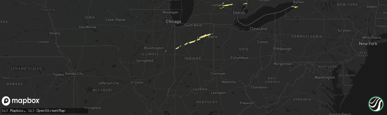
Hail
33,866
Estimated number of impacted properties by a 1.00" hail or larger803
Estimated number of impacted properties by a 1.75" hail or larger0
Estimated number of impacted properties by a 2.50" hail or largerStorm reports in Indiana
Indiana
| Date | Description |
|---|---|
| 02/18/20265:39 AM CST | Reported as toonie sized - 1.1 inch. |
| 02/18/20265:33 AM CST | Time estimated by radar. |
| 02/18/20265:31 AM CST | Report from mping: quarter |
| 02/18/20265:21 AM CST | Pictures shared on facebook of lots of smaller hail... But at least 1 hail stone the size of a half dollar. |
| 02/18/20265:01 AM CST | Picture relayed by off duty nws employee of several hailstones over 1 inch in diameter. |
| 02/18/20264:55 AM CST | Off duty nws employee reporting lots of mainly pea size hail with a few larger pieces of nickel to quarter size noted. |
| 02/18/20264:46 AM CST | Measured just over 1.5 inch hail stone. |
| 02/18/20264:46 AM CST | Time estimated by radar. |
| 02/18/20264:15 AM CST | A local report indicates 1.00 inch wind near North Manchester |
| 02/18/20264:05 AM CST | Completely covered the ground with stones ranging from half to 1.5 inch in diameter. |
| 02/18/20264:05 AM CST | Streets and lawns were covered in stones ranging up to 1 inch in diameter. |
| 02/18/20263:30 AM CST | Em sent picture of at least quarter size hail. |
| 02/18/20263:12 AM CST | Picture from em of at least quarter size hail. |
| 02/18/20263:00 AM CST | Picture shared by ema of a estimated 1 inch diameter hail stone. |
| 02/18/20262:37 AM CST | Report from mping: quarter |
| 02/18/20261:50 AM CST | Several photos shared on social media of quarter-sized hail near oxford. Time estimated from radar. |
| 02/18/20261:36 AM CST | Location is approximate. Hail was covering the road. |
Cities Impacted by Hail Map on February 18, 2026
- Howell, MI
- Fowlerville, MI
- Linden, MI
- Fenton, MI
- Davisburg, MI
- Holly, MI
- Angola, NY
- Irving, NY
- Williamston, MI
- Okemos, MI
- Clarkston, MI
- Webberville, MI
- Ambia, IN
- Oxford, IN
- Boswell, IN
- Pine Village, IN
- Fowler, IN
- Otterbein, IN
- North Collins, NY
- Eden, NY
- Brookston, IN
- Casco, MI
- East China, MI
- Saint Clair, MI
- Delphi, IN
- Yeoman, IN
- Monticello, IN
- Chalmers, IN
- Idaville, IN
- Burnettsville, IN
- Logansport, IN
- Royal Center, IN
- Twelve Mile, IN
- Peru, IN
- Denver, IN
- Mexico, IN
- Roann, IN
- Wabash, IN
- North Manchester, IN
- Servia, IN
- South Whitley, IN
- Claypool, IN
- Liberty Mills, IN
- Columbia City, IN
- Macy, IN
- Dansville, MI
- Fort Wayne, IN
- Churubusco, IN
- Arcola, IN
- Leo, IN
- Grabill, IN
- New Haven, MI
- Perry, MI
- Morrice, MI
- Harlan, IN
- Silver Lake, IN
- Rantoul, IL


