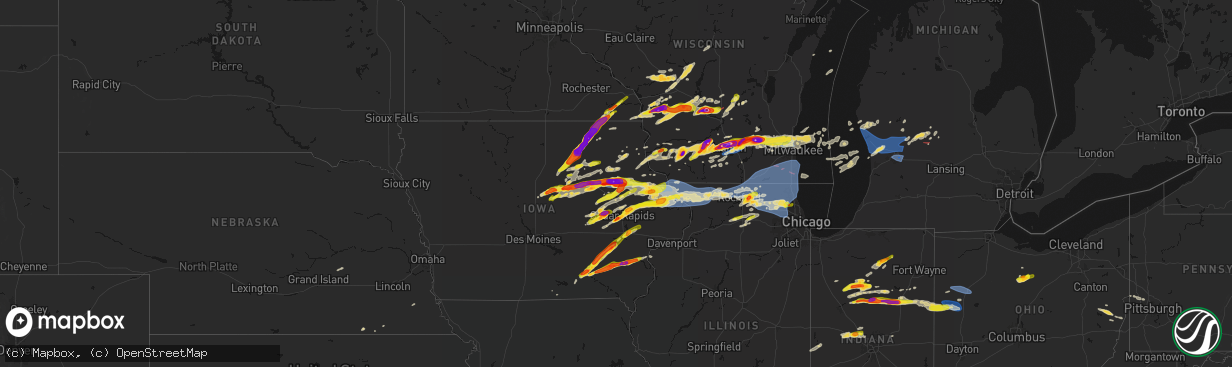
Hail Map on April 14, 2026
The weather event on April 14, 2026 includes Hail, Tornado, and Wind maps. 18 states and 1,229 cities were impacted and suffered possible damage. The total estimated number of properties impacted is 570,372.
Hail
Tornado
Wind
570,372
Estimated number of impacted properties by a 1.00" hail or larger183,172
Estimated number of impacted properties by a 1.75" hail or larger130,400
Estimated number of impacted properties by a 2.50" hail or largerStates Impacted by Hail Map on April 14, 2026
Storm reports
Ohio
| Date | Description |
|---|---|
| 04/14/20266:51 PM CDT | . |
| 04/14/20266:40 PM CDT | Roof torn off steer barn off sr 364. Time estimated from radar. |
| 04/14/20266:40 PM CDT | Poles down on waesch road. Time estimated from radar. |
| 04/14/20266:40 PM CDT | Poles down on west road. Time estimated from radar. |
| 04/14/20266:39 PM CDT | Awos station kaoh 2 wnw westminster. |
| 04/14/20266:33 PM CDT | A local report indicates 65 MPH wind near 1 NNE Southworth |
| 04/14/20266:32 PM CDT | Roof and structural damage to separate barns on brockman and harrison and 716a and harrison. Time estimated from radar. |
| 04/14/20266:27 PM CDT | Large tree branches down. Report from social media. Time estimated from radar. |
| 04/14/20264:35 PM CDT | A local report indicates 1.25 inch wind near Hopedale |
| 04/14/20264:35 PM CDT | A local report indicates 1.00 inch wind near Hopedale |
| 04/14/202612:58 PM CDT | Utility pole and wires down. |
| 04/13/20268:37 PM CDT | A tree was snapped along its trunk and blocked the roadway. |
| 04/13/20268:36 PM CDT | Side of barn blown out and barn pushed off foundation. Trailer with iron frame blown on to its side. Trees uprooted and broken along griffith rd. |
| 04/13/20268:29 PM CDT | Numerous trees downed near the intersection of burg street and new burg street. |
| 04/13/20268:28 PM CDT | Photo posted on social media of tree down on power pole. Time estimated from radar. |
| 04/13/20268:24 PM CDT | Public report of property damage including several large trees that were uprooted and a portion of barn roofing blown off. |
| 04/13/20268:15 PM CDT | Numerous trees downed along peter hoover road. Trees onto home. Numerous trees snapped. Time estimated by radar. |
| 04/13/20267:27 PM CDT | A tree was downed across e liberty road near state route 347. |
| 04/13/20267:23 PM CDT | Roof torn off barn. Time estimated from radar. |
| 04/13/20267:22 PM CDT | Damage to trees on property. Cement pond damaged. Time estimated from radar. |
| 04/13/20267:22 PM CDT | Corrects previous tstm wnd dmg report from 4 w west mansfield. Power poles snapped at sr47 and county road 12 intersection. Time estimated from radar. |
| 04/13/20267:21 PM CDT | Tree down on sr47. Time estimated from radar. |
| 04/13/20267:19 PM CDT | Tree down blocking road on county road 26. Time estimated from radar. |
| 04/13/20267:18 PM CDT | Extensive damage to benjamin logan elementary school. Time estimated from radar. |
| 04/13/20267:16 PM CDT | Parked bus flipped and rotated on sr47. Time estimated from radar. |
| 04/13/20267:08 PM CDT | One inch size hail along sr 98. |
Vermont
| Date | Description |
|---|---|
| 04/14/20265:40 PM CDT | Tree down along vt route 142 in vernon. |
| 04/14/20265:38 PM CDT | Report of tree down across rte 91 off ramp at exit 1. |
| 04/14/20265:33 PM CDT | Corrects previous tstm wnd dmg report from brattleboro. Social media report of trees down in brattleboro at maple st near guilford rd. |
| 04/14/20265:33 PM CDT | Social media report of trees down in brattleboro. |
Oklahoma
| Date | Description |
|---|---|
| 04/14/20266:55 PM CDT | A local report indicates 61 MPH wind near 4 SE Hobart |
| 04/14/20266:54 PM CDT | A local report indicates 58 MPH wind near 3 SE Hobart |
| 04/14/20266:52 PM CDT | A local report indicates 70 MPH wind near 3 SE Hobart |
| 04/14/20266:35 PM CDT | Damage to a home. Radar estimated time. |
| 04/14/20266:19 PM CDT | Kfor chaser. |
| 04/14/20265:46 PM CDT | Report from mping: quarter |
| 04/14/20265:39 PM CDT | A local report indicates 1.25 inch wind near 1 NW Elk City |
| 04/14/20265:34 PM CDT | A local report indicates 84 MPH wind near 2 NE Elk City |
| 04/14/20265:33 PM CDT | Structural damage. Time is estimated. |
| 04/14/20265:25 PM CDT | A local report indicates 1.00 inch wind near 1 WNW Elk City |
| 04/14/20264:43 PM CDT | Quarter sized hail reported in grandfield. |
| 04/14/202611:28 AM CDT | Tree limbs and power lines down near state highway 82 and park hill road. Time estimated from radar. |
| 04/13/202611:28 PM CDT | Corrects time of previous tstm wnd dmg report from 5 s tahlequah. Tree limbs and power lines down near state highway 82 and park hill road. Time estimated from radar. |
| 04/13/202611:20 PM CDT | A local report indicates 59 MPH wind near 1 WNW Webbers Falls |
| 04/13/202611:00 PM CDT | Several reports of lrage trees and power lines down via soical media post. Time estimated from radar. |
| 04/13/202610:12 PM CDT | Near 138th and 11th street. |
| 04/13/202610:11 PM CDT | A local report indicates 60 MPH wind near 4 ENE Tulsa |
| 04/13/20269:59 PM CDT | Power lines and poles down in the area. Timing estimated based on radar data. |
| 04/13/20269:54 PM CDT | Tds observed from kinx. Location was near 71st and us highway 75. Timing based on radar data. |
| 04/13/20269:51 PM CDT | Carport down on car...estimated 3 foot diameter trees toppled/uprooted...powerlines down...shingles missing from nearby homes. Time estimated from radar. |
| 04/13/20269:50 PM CDT | Amatuer radion report of multiple trees down on 81st street s between 33rd st w and 49th st w. Time estimated from radar. |
| 04/13/20267:30 PM CDT | A local report indicates 58 MPH wind near 4 S Tipton |
Illinois
| Date | Description |
|---|---|
| 04/14/20263:06 AM CDT | Report from mping: quarter |
| 04/13/202610:38 PM CDT | Report from mping: quarter |
| 04/13/202610:34 PM CDT | Report from mping: quarter |
| 04/13/202610:21 PM CDT | A local report indicates 1.00 inch wind near 2 W South Elgin |
| 04/13/202610:20 PM CDT | Measured at a personal weather station. A separate pws nearby reported a similar gust. |
| 04/13/202610:03 PM CDT | Report from mping: quarter |
| 04/13/202610:00 PM CDT | Report of wire down il-47 and burlington road. |
| 04/13/20269:47 PM CDT | Report from mping: quarter |
| 04/13/20269:44 PM CDT | A local report indicates 1.00 inch wind near 1 N DeKalb |
| 04/13/20269:42 PM CDT | Public report of hail up to 1.25 inches in diameter. |
| 04/13/20269:40 PM CDT | Picture shared of 1.0-1.25 inch hail in dekalb. Time estimated via radar. |
| 04/13/20269:38 PM CDT | Pea to quarter size hail reported in dekalb. Time estimated via radar. |
| 04/13/20269:25 PM CDT | Report of power lines down north side of hampshire. Time estimated by radar. |
| 04/13/20269:13 PM CDT | Measured at an ambient personal weather station. |
| 04/13/20269:11 PM CDT | Relayed by broadcast media. Time estimated by radar. |
| 04/13/20269:06 PM CDT | Spotter reported a measured 72 mph gust relayed by em. Time estimated from radar. |
| 04/13/20269:05 PM CDT | A local report indicates 1.00 inch wind near 3 SE Timberlane |
| 04/13/20269:05 PM CDT | Public report of half dollar size hail northwest of garden prairie. Time estimated by radar. |
| 04/13/20269:03 PM CDT | Relayed social media. |
| 04/13/20269:00 PM CDT | Relayed social media. |
| 04/13/20268:56 PM CDT | A local report indicates 1.75 inch wind near 1 WNW Belvidere |
| 04/13/20268:56 PM CDT | Relayed by broadcast media. Time estimated by radar. |
| 04/13/20268:45 PM CDT | Relayed by broadcast media. Time estimated by radar. |
| 04/13/20268:38 PM CDT | A local report indicates 63 MPH wind near 1 W Harvard |
| 04/13/20267:47 PM CDT | Barn flew across the road and took out 8 power poles. Time estimated from radar. |
| 04/13/20267:45 PM CDT | Trees down blocking roads. Tornado possible. |
Pennsylvania
| Date | Description |
|---|---|
| 04/14/20266:33 PM CDT | Large road construction signs blown onto roadway blocking both lanes. |
| 04/14/20265:47 PM CDT | Tree down on rosenbaum road by lincoln highway. |
| 04/14/20265:00 PM CDT | 50x50 foot open-face wooden hay storage barn blown down. |
| 04/14/20263:50 PM CDT | Multiple trees down in several locations including kennedy hill... Morado road... And kennedy boulevard. |
| 04/14/20263:46 PM CDT | Large tree uprooted. Fell on shed and car. Corrects previous tstm wnd dmg report from 1 s aliquippa. |
| 04/14/20263:45 PM CDT | Corrects previous tstm wnd dmg report from 1 wsw aliquippa. Multiple trees down in several locations including kennedy hill... Morado road... And kennedy boulevard. |
| 04/14/20263:42 PM CDT | A local report indicates 1.25 inch wind near 4 ESE Industry |
| 04/14/20263:16 PM CDT | Utility pole down. |
Wisconsin
| Date | Description |
|---|---|
| 04/14/20266:59 PM CDT | A local report indicates 1.00 inch wind near 2 SSE Germantown |
| 04/14/20266:55 PM CDT | A local report indicates 1.25 inch wind near 3 SSE Germantown |
| 04/14/20266:54 PM CDT | A local report indicates 70 MPH wind near 3 W Sinsinawa |
| 04/14/20266:47 PM CDT | Report from mping: quarter |
| 04/14/20266:47 PM CDT | A local report indicates 1.00 inch wind near Germantown |
| 04/14/20266:46 PM CDT | Report from mping: ping pong ball |
| 04/14/20266:41 PM CDT | Photo from social media with coins. Time estimated from radar. |
| 04/14/20266:40 PM CDT | Report from mping: quarter |
| 04/14/20266:38 PM CDT | Photo from social media with a tape measure. Time estimate from radar. |
| 04/14/20266:38 PM CDT | A local report indicates 1.25 inch wind near 3 S Richfield |
| 04/14/20266:38 PM CDT | Photo from social media with a tape measure. |
| 04/14/20266:31 PM CDT | Trained spotter measures softball sized hail near maple bluff. |
| 04/14/20266:30 PM CDT | Report from mping: quarter |
| 04/14/20266:28 PM CDT | Corrects previous tornado report date and time from 4 ssw endeavor. Nws storm survey found ef1 tornado damage southwest of endeavor. Brief tornado had a 50 yard wide pa |
| 04/14/20266:28 PM CDT | Time estimated by radar. |
| 04/14/20266:27 PM CDT | Radar confirmed tornadic debris signature at this location. Multiple roofs ripped off a commercial facility reported by law enforcement. Siding damage to nearby church. |
| 04/14/20266:25 PM CDT | Report from mping: baseball |
| 04/14/20266:24 PM CDT | Trained spotter reports 2 inch diameter hail in endeavor. |
| 04/14/20266:22 PM CDT | Nws storm survey found ef2 tornado damage in the town of lisbon. Maximum winds 120 mph. Path length 3.2 miles. Duration 6 minutes. Complete loss of roof on southern sid |
| 04/14/20266:20 PM CDT | Time estimated by radar. |
| 04/14/20266:20 PM CDT | Trained spotter reports thunderstorm wind damage. |
| 04/14/20266:19 PM CDT | Verified via photo with coins from social media. |
| 04/14/20266:17 PM CDT | Photo provided via social media. |
| 04/14/20266:16 PM CDT | A local report indicates 1.00 inch wind near Hartland |
| 04/14/20266:12 PM CDT | Photo from social media with a quarter for comparison. |
| 04/14/20266:06 PM CDT | Report from mping: quarter |
| 04/14/20266:01 PM CDT | Report from mping: ping pong ball |
| 04/14/20266:00 PM CDT | A local report indicates 3.00 inch wind near 4 SSW Plainville |
| 04/14/20266:00 PM CDT | Report from mping: quarter |
| 04/14/20265:57 PM CDT | A local report indicates 2.75 inch wind near 2 SE Watertown |
| 04/14/20265:56 PM CDT | Report from mping: quarter |
| 04/14/20265:55 PM CDT | A local report indicates 1.00 inch wind near 6 ENE Wonewoc |
| 04/14/20265:52 PM CDT | Report from mping: hen egg |
| 04/14/20265:52 PM CDT | A local report indicates 1.75 inch wind near Watertown |
| 04/14/20265:50 PM CDT | Photo from social media with a quarter for comparison. |
| 04/14/20265:49 PM CDT | Report from mping: half dollar |
| 04/14/20265:49 PM CDT | Report from mping: quarter |
| 04/14/20265:48 PM CDT | Report from mping: quarter |
| 04/14/20265:48 PM CDT | Report from mping: golf ball |
| 04/14/20265:47 PM CDT | Report from mping: quarter |
| 04/14/20265:45 PM CDT | Report from mping: tennis ball |
| 04/14/20265:44 PM CDT | Report from mping: golf ball |
| 04/14/20265:40 PM CDT | A local report indicates 1.75 inch wind near Cobb |
| 04/14/20265:39 PM CDT | Report from mping: baseball+ |
| 04/14/20265:38 PM CDT | A local report indicates 1.75 inch wind near 1 SSE Hillsboro |
| 04/14/20265:37 PM CDT | Report from mping: hen egg+ |
| 04/14/20265:37 PM CDT | Radar confirmed tornado with debris signature. House destroyed on raese rd northwest of union center. The tornado was reported to continue northeast crossing state high |
| 04/14/20265:37 PM CDT | A local report indicates 1.25 inch wind near Coon Valley |
| 04/14/20265:37 PM CDT | Corrects previous hail report from 3 e maple bluff. Trained spotter reports measured hail stones as large as 3.5 inches in diameter. |
| 04/14/20265:35 PM CDT | A local report indicates 2.50 inch wind near Cottage Grove |
| 04/14/20265:34 PM CDT | Report from mping: tea cup |
| 04/14/20265:34 PM CDT | A local report indicates 1.00 inch wind near Patch Grove |
| 04/14/20265:34 PM CDT | Report from mping: golf ball |
| 04/14/20265:34 PM CDT | A local report indicates 1.00 inch wind near 3 W Hillsboro |
| 04/14/20265:33 PM CDT | Report from mping: hen egg |
| 04/14/20265:33 PM CDT | The tornado begin in rural areas west-northwest of union center continuing northeast for almost 9 miles. The worst damage... Rated lower ef3 with winds to 140 mph... Wa |
| 04/14/20265:32 PM CDT | Report from mping: golf ball |
| 04/14/20265:31 PM CDT | Report from mping: quarter |
| 04/14/20265:30 PM CDT | Report from mping: quarter |
| 04/14/20265:29 PM CDT | Report from mping: hen egg |
| 04/14/20265:27 PM CDT | Report from mping: ping pong ball |
| 04/14/20265:27 PM CDT | Report from mping: quarter |
| 04/14/20265:27 PM CDT | Report from mping: half dollar |
| 04/14/20265:26 PM CDT | A local report indicates 1.00 inch wind near 1 SW Sun Prairie |
| 04/14/20265:26 PM CDT | Report from mping: golf ball |
| 04/14/20265:25 PM CDT | A local report indicates a tornado near 5 E Mount Hope |
| 04/14/20265:25 PM CDT | A local report indicates 3.00 inch wind near 1 ESE Maple Bluff |
| 04/14/20265:24 PM CDT | A local report indicates 2.50 inch wind near 3 E Maple Bluff |
| 04/14/20265:23 PM CDT | Report from mping: half dollar |
| 04/14/20265:23 PM CDT | Report from mping: half dollar |
| 04/14/20265:22 PM CDT | Trained spotter measures 2 inch diameter hail. |
| 04/14/20265:20 PM CDT | A local report indicates 2.75 inch wind near 1 SE Maple Bluff |
| 04/14/20265:20 PM CDT | Photo from social media. |
| 04/14/20265:19 PM CDT | Report from mping: ping pong ball |
| 04/14/20265:18 PM CDT | Report from mping: baseball |
| 04/14/20265:17 PM CDT | Report from mping: quarter |
| 04/14/20265:17 PM CDT | Report from mping: quarter |
| 04/14/20265:15 PM CDT | Picture provided via social media. |
| 04/14/20265:14 PM CDT | Report from mping: quarter |
| 04/14/20265:13 PM CDT | Report from mping: quarter |
| 04/14/20265:13 PM CDT | Report from mping: quarter |
| 04/14/20265:10 PM CDT | Report from mping: quarter |
| 04/14/20265:09 PM CDT | Report from mping: hen egg |
| 04/14/20265:07 PM CDT | A local report indicates 2.00 inch wind near 2 S Marshall |
| 04/14/20265:07 PM CDT | Report from mping: quarter |
| 04/14/20265:07 PM CDT | Report from mping: ping pong ball |
| 04/14/20265:06 PM CDT | Report from mping: hen egg |
| 04/14/20265:05 PM CDT | A local report indicates 1.00 inch wind near 3 NE Mount Hope |
| 04/14/20265:02 PM CDT | A local report indicates 1.50 inch wind near Middleton |
| 04/14/20265:02 PM CDT | A local report indicates 3.00 inch wind near 1 NW Maple Bluff |
| 04/14/20265:00 PM CDT | A local report indicates 1.00 inch wind near 2 N Maple Bluff |
| 04/14/20265:00 PM CDT | Trained spotter reports hail stones up to 2 inches in diameter. |
| 04/14/20265:00 PM CDT | A local report indicates 1.00 inch wind near 1 SE Maple Bluff |
| 04/14/20264:59 PM CDT | A local report indicates 2.00 inch wind near 3 NE Middleton |
| 04/14/20264:58 PM CDT | Report from mping: golf ball |
| 04/14/20264:57 PM CDT | A local report indicates 2.75 inch wind near 3 SW Cashton |
| 04/14/20264:57 PM CDT | Report from mping: half dollar |
| 04/14/20264:55 PM CDT | Report from mping: ping pong ball |
| 04/14/20264:55 PM CDT | Report from mping: golf ball |
| 04/14/20264:55 PM CDT | Report from mping: quarter |
| 04/14/20264:55 PM CDT | A local report indicates 2.50 inch wind near Middleton |
| 04/14/20264:54 PM CDT | Report from mping: quarter |
| 04/14/20264:54 PM CDT | Report from mping: ping pong ball |
| 04/14/20264:52 PM CDT | A local report indicates 2.00 inch wind near 2 S Middleton |
| 04/14/20264:51 PM CDT | Windshields broken on patrol car. |
| 04/14/20264:50 PM CDT | Report from mping: quarter |
| 04/14/20264:49 PM CDT | A local report indicates 1.25 inch wind near 3 NE Deerfield |
| 04/14/20264:49 PM CDT | Report from mping: half dollar |
| 04/14/20264:49 PM CDT | Report from mping: half dollar |
| 04/14/20264:49 PM CDT | Report from mping: half dollar |
| 04/14/20264:47 PM CDT | A local report indicates 1.00 inch wind near Deerfield |
| 04/14/20264:46 PM CDT | A local report indicates 1.75 inch wind near 1 WNW Esofea |
| 04/14/20264:45 PM CDT | Photo provided via social media. |
| 04/14/20264:45 PM CDT | Trained spotter measures hail stones as large as 2.75 inches in diameter. |
| 04/14/20264:45 PM CDT | Photo from social media with a quarter for comparison. |
| 04/14/20264:44 PM CDT | A local report indicates 1.75 inch wind near 1 W Middleton |
| 04/14/20264:39 PM CDT | Report from mping: quarter |
| 04/14/20264:38 PM CDT | One hail stone of 2 inch diameter. |
| 04/14/20264:38 PM CDT | A local report indicates 2.50 inch wind near 1 E Mazomanie |
| 04/14/20264:36 PM CDT | Baseball sized hail falling causing significant damage to siding and roofs in the area. |
| 04/14/20264:34 PM CDT | Report from mping: quarter |
| 04/14/20264:33 PM CDT | Report from mping: quarter |
| 04/14/20264:31 PM CDT | A local report indicates 1.75 inch wind near 4 W Black Earth |
| 04/14/20264:29 PM CDT | A local report indicates 2.00 inch wind near 5 SE Arena |
| 04/14/20264:25 PM CDT | A local report indicates 1.00 inch wind near 4 ENE Genoa |
| 04/14/20264:23 PM CDT | Report from mping: quarter |
| 04/14/20264:21 PM CDT | A local report indicates 1.50 inch wind near 2 W Barneveld |
| 04/14/20264:17 PM CDT | A local report indicates 1.00 inch wind near Barneveld |
| 04/14/20263:52 PM CDT | A local report indicates 1.00 inch wind near 2 NE Mineral Point |
| 04/13/20269:04 PM CDT | A local report indicates 1.00 inch wind near 4 S Gillingham |
| 04/13/20268:38 PM CDT | Trained spotter reports uprooted trees in addition to shingle & chimney damage. |
| 04/13/20268:29 PM CDT | Nws storm survey found ef1 tornado damage southwest of east troy. Maximum winds of 100 mph. |
| 04/13/20267:55 PM CDT | Trained spotter estimates 70 mph winds. |
| 04/13/20267:48 PM CDT | Trained spotter reports broken tree branches and limbs. |
| 04/13/20267:29 PM CDT | Trained spotter reports baseball-sized hail. Multiple vehicles with broken glass. |
| 04/13/20267:19 PM CDT | Report from mping: hen egg |
| 04/13/20267:07 PM CDT | Trained spotter estimates baseball sized hail. |
| 04/13/20267:02 PM CDT | Report from mping: quarter |
| 04/13/20267:02 PM CDT | Report from mping: hen egg+ |
| 04/13/20267:00 PM CDT | Trained spotter estimates 70 mph winds. |
Minnesota
| Date | Description |
|---|---|
| 04/14/20266:25 PM CDT | 1 to 1 1/4 inch hail. |
| 04/14/20265:53 PM CDT | Report from mping: quarter |
| 04/14/20265:40 PM CDT | A local report indicates 1.50 inch wind near 1 WNW Harmony |
Massachusetts
| Date | Description |
|---|---|
| 04/14/20266:55 PM CDT | Tree downed on wires near turkey hill rd. Relayed by amateur radio. |
| 04/14/20266:40 PM CDT | Multiple trees and powerline wires downed on laurel drive in hadley. |
| 04/14/20266:40 PM CDT | Powerline wires downed near indian hill rd. |
| 04/14/20266:35 PM CDT | Small tree downed on massachusetts route 8a near hawley. |
| 04/14/20266:30 PM CDT | Tree downed at intersection of meridian st and colorado ave in greenfield. Relayed by amateur radio. |
| 04/14/20266:28 PM CDT | Tree downed blocking portions of upper rd in deerfield. |
| 04/14/20266:27 PM CDT | Corrects previous tstm wnd dmg report from 3 nnw plainfield for time. Small tree downed on massachusetts route 8a near hawley. |
| 04/14/20266:10 PM CDT | Report of large limb down on spring street. |
| 04/14/20265:58 PM CDT | A local report indicates 59 MPH wind near 2 SW Pittsfield |
| 04/14/20265:56 PM CDT | Report of tree down blocking road on swamp rd. |
| 04/13/20267:10 PM CDT | Tree down on a house near crescent street in lancaster. Relayed by amateur radio. |
| 04/13/20267:09 PM CDT | Tree downed on a house near manning street in holden. |
| 04/13/20267:00 PM CDT | Downed trees and wires near ball hill rd in princeton. Relayed by amateur radio. |
Kansas
| Date | Description |
|---|---|
| 04/13/202610:48 PM CDT | Wind report based on personal weather station. Appears to be in the vicinity of other wind signatures on radar. |
| 04/13/20269:20 PM CDT | Report relayed via social media. Time estimated by radar. |
| 04/13/20269:04 PM CDT | Social media post. |
Nebraska
| Date | Description |
|---|---|
| 04/13/202610:17 PM CDT | Spotter reported quarter-sized hail in beatrice... Time estimated from radar. |
Indiana
| Date | Description |
|---|---|
| 04/14/20266:04 PM CDT | A local report indicates 1.00 inch wind near 1 S Montpelier |
| 04/14/20265:40 PM CDT | Tree downed by t-storm winds. Time estimated from radar. |
| 04/14/20265:27 PM CDT | A local report indicates 1.50 inch wind near 2 N Marion |
| 04/14/20265:24 PM CDT | A local report indicates 1.75 inch wind near 2 S Marion |
| 04/14/20265:22 PM CDT | A local report indicates 1.00 inch wind near 2 NW Marion |
| 04/14/20264:56 PM CDT | A local report indicates 1.25 inch wind near 3 S Santa Fe |
| 04/14/20264:50 PM CDT | A local report indicates 1.00 inch wind near 2 ENE Warsaw |
| 04/14/20264:42 PM CDT | A local report indicates 1.25 inch wind near 2 WSW Wawpecong |
| 04/14/20264:40 PM CDT | Near us-31 just south of miami county line. Time estimated from radar. |
| 04/14/20264:35 PM CDT | A local report indicates 1.25 inch wind near 5 N Kokomo |
| 04/14/20264:35 PM CDT | A local report indicates 1.50 inch wind near 3 N Palestine |
| 04/14/20264:15 PM CDT | A local report indicates 1.50 inch wind near 4 S Lebanon |
| 04/14/20263:58 PM CDT | Golf ball size hail. |
Missouri
| Date | Description |
|---|---|
| 04/14/202612:00 PM CDT | Social media report. Time estimated from radar. |
| 04/14/20261:23 AM CDT | Half of a tree took out a powerline in aurora. |
| 04/14/202612:26 AM CDT | Delayed report of a tree down near a residence on k highway. |
| 04/14/202612:25 AM CDT | Delayed report of a tree down on big sugar creek road west of craig o lea lane. |
| 04/14/202612:20 AM CDT | A tree knocked down powerlines in the noel area. |
New York
| Date | Description |
|---|---|
| 04/14/20266:59 PM CDT | Tree down blocking county road 116 in lake huntington. |
| 04/14/20266:02 PM CDT | Tree down blocking both lanes of big hollow road in sanford. |
| 04/14/20265:17 PM CDT | Report of trees snapped/uprooted near intersection of pinehurst and route 155. |
| 04/14/20265:13 PM CDT | *** 1 inj *** media report of downed tree near spring avenue and kinloch avenue. One injury reported from this event. |
| 04/14/20265:08 PM CDT | Report of downed trees in the north bethlehem/slingerlands area. |
| 04/14/20265:08 PM CDT | Corrects previous tstm wnd dmg report from 2 se westmere. Report of downed trees near the intersection of blessing rd and krumkill rd. |
| 04/14/20265:03 PM CDT | Social media report of trees downed on martin court in clifton park. |
| 04/14/20264:06 PM CDT | Glens falls asos gusted to 62.1 mph. |
| 04/14/20263:47 PM CDT | Multiple trees down. |
| 04/14/20263:44 PM CDT | Social media report of a downed tree in warrensburg. |
| 04/14/20262:49 PM CDT | Nws albany received a ny travel alert of a downed tree on ny 28 between old route 28 and john rust road in indian lake that blocked one lane of traffic heading eastboun |
| 04/13/20268:10 PM CDT | Ny alert report: large tree limbs down blocking one lane on ny-22 amenia. |
| 04/13/20267:40 PM CDT | Tree and wires down on rt 209 near kyserike rd near accord. |
| 04/13/20267:26 PM CDT | Tree down blocking roadway on wild turnpike road. |
| 04/13/20267:14 PM CDT | Tree down blocking road. |
| 04/13/20267:14 PM CDT | Tree blocking roadway at columbia hill road. |
| 04/13/20267:14 PM CDT | Wires down on roadway. |
Michigan
| Date | Description |
|---|---|
| 04/14/20261:17 AM CDT | Damage to trees and power lines starting around the i-275 and i-75 interchange spreading east toward estral beach |
| 04/14/20261:14 AM CDT | Nws storm survey team confirms an ef-1 tornado occurred in lincoln park on april 15. A brief tornado touched down near wall ave and ruth ave... And continued across res |
| 04/14/20261:08 AM CDT | Measured at willow run airport. |
| 04/14/20261:08 AM CDT | A local report indicates 69 MPH wind near Detroit Metro Intl Airp |
| 04/14/20261:05 AM CDT | Power lines and poles down across middle belt rd south of van born in romulus. |
| 04/14/202612:49 AM CDT | Measured at the university of michigan stadium. |
| 04/14/202612:45 AM CDT | Trees and power lines reported down across parts of the county... Especially in the ann arbor and ypsilanti area. |
| 04/14/202612:44 AM CDT | Nws storm survey team confirms an ef-1 tornado occurred in ann arbor on april 15. The tornado started in the area of jackson ave near interstate 94... Continued southea |
| 04/14/202612:38 AM CDT | Tree down blocking southbound lane of parker road between trinkle road and i-94. Reports of debris in the area. |
| 04/14/202612:25 AM CDT | Numerous trees and powerlines down... Along with damage to a large shed. |
| 04/14/202612:20 AM CDT | Trained spotter reported trees and powerlines down near bibbins road and us-12 intersection due to thunderstorm winds in hillsdale county in michigan. |
| 04/13/202611:32 PM CDT | Six inch diameter tree limb down. |
| 04/13/202611:10 PM CDT | Many twisted and broken trees down on property. Barn roof removed. Neighbors greenhouse ended up in their yard. Time approximate. |
| 04/13/202611:09 PM CDT | Several limbs and trees down along with trees uprooted in western genesee along grand blanc rd to seymour rd. Tim estimated off radar. |
| 04/13/202611:06 PM CDT | Nws storm survey team confirms an ef-0 tornado occurred in bridgeport on april 15. The tornado started northwest of roedel rd and s reimer rd... Continued southeast bef |
| 04/13/202611:00 PM CDT | Trees uprooted. |
| 04/13/202611:00 PM CDT | Roof damage along with greenhouse damage. Trees down as well. Time and location approximate. |
| 04/13/202610:58 PM CDT | Nws storm survey team confirms an ef-0 tornado occurred in durand on april 14. The tornado started near newburg rd just west of lansing rd... Continued east before lift |
| 04/13/202610:53 PM CDT | Nws storm survey confirms an ef-1 tornado occurred in albee township on april 14. The tornado started just northwest of w birch run rd and amman rd... Continued northea |
| 04/13/202610:52 PM CDT | This ef-1 tornado had maximum estimated winds of 100 mph and a path of around 16 miles. It touched down north of otsego and traveled east until hickory corners. This to |
| 04/13/202610:49 PM CDT | Some shingles from a house ripped off and downed trees. |
| 04/13/202610:49 PM CDT | A few pieces of siding from a house ripped off and downed trees. |
| 04/13/202610:40 PM CDT | Trees reported down near grand river road and delaney road. |
| 04/13/202610:38 PM CDT | An ef-0 tornado with peak winds near 80 mph began near schermerhorn lake in allegan county and was on the ground for around 6.5 miles before lifting west/northwest of o |
| 04/13/202610:11 PM CDT | A local report indicates 60 MPH wind near 1 W East Grand Rapids |
| 04/13/202610:00 PM CDT | Tree on house in the alto area. Time and location approximate. |
| 04/13/20269:58 PM CDT | A surge of thunderstorm winds occurred from the grand rapids airport southeast through the whitneyville area... Where a large tree fell on a house... Doing extensive da |
| 04/13/20269:57 PM CDT | Asos station kgrr gerald r ford intl. |
| 04/13/20269:51 PM CDT | An ef1 tornado with top winds near 110 mph began 2 miles east of fenwick in montcalm county... Moving east-northeast almost 19 miles before ending just east of perrinto |
| 04/13/20269:50 PM CDT | Delayed report. Lots of 10-12 inch trees down... Generally in one direction. Damage seems to be condensed to a small area between given location and county line rd. Tim |
| 04/13/20269:50 PM CDT | Gust at the gerald r ford international airport. |
| 04/13/20269:31 PM CDT | A local report indicates 61 MPH wind near 1 SW Comstock Park |
Arkansas
| Date | Description |
|---|---|
| 04/14/202612:30 AM CDT | 62 mph wind gusts east of springdale. Time estimated based on radar data. |
| 04/14/202612:20 AM CDT | Public report of trees down near pinnacle country club relayed by broadcast media. Time estimated from radar. |
| 04/14/202612:15 AM CDT | Power poles snapped and lines down on kelly ave near pine tree lane. Time estimated from radar. |
| 04/14/202612:01 AM CDT | Barn and trees damaged. |
| 04/13/202611:59 PM CDT | Trees uprooted and large tree branches broken. Photos and report relayed by media. |
Texas
| Date | Description |
|---|---|
| 04/14/20266:54 PM CDT | Ping pong ball size hail on lake amistad. Time estimated from radar. |
| 04/14/20266:54 PM CDT | The emergency manager reported 60 mph wind gusts estimated on lake amistad. Time estimated from radar. |
| 04/14/20265:47 PM CDT | A local report indicates 64 MPH wind near 8 SE Guthrie |
| 04/14/20265:19 PM CDT | A local report indicates 1.50 inch wind near 6 SW Thalia |
| 04/14/20264:31 PM CDT | A local report indicates 1.50 inch wind near Comstock |
| 04/13/20268:56 PM CDT | Photos sent by emergency manager of several sheets of corrugated tin making up the roof and walls of an unused airport hangar were stripped away with what appeared to b |
| 04/13/20268:55 PM CDT | Awos station kbpg big spring. |
| 04/13/20268:05 PM CDT | Large ground mounted flagpole blown down. Time estimated by radar. |
Iowa
| Date | Description |
|---|---|
| 04/14/20266:50 PM CDT | Photo provided. Time estimated using radar. |
| 04/14/20266:49 PM CDT | Report from mping: ping pong ball |
| 04/14/20266:48 PM CDT | A local report indicates 1.00 inch wind near 4 SE Langworthy |
| 04/14/20266:41 PM CDT | Asos. |
| 04/14/20266:32 PM CDT | Small tree branches/ limbs down. |
| 04/14/20266:30 PM CDT | Storm chaser report. Time estimated from radar. |
| 04/14/20266:30 PM CDT | Possible tornado. |
| 04/14/20266:29 PM CDT | A local report indicates 2.00 inch wind near Noble |
| 04/14/20266:27 PM CDT | Efu tornado confirmed based on multiple chaser videos and spotter reports. No known damage along its estimated 2.6 mile path. Tornado path determined by radar and video |
| 04/14/20266:27 PM CDT | Tree debris in the road. Possible tornado. |
| 04/14/20266:21 PM CDT | A local report indicates 1.00 inch wind near 3 NW Center Junction |
| 04/14/20266:21 PM CDT | Report from mping: ping pong ball |
| 04/14/20266:18 PM CDT | A local report indicates 1.00 inch wind near 2 SSE Hudson |
| 04/14/20266:17 PM CDT | A local report indicates 1.00 inch wind near 1 WSW Langworthy |
| 04/14/20266:12 PM CDT | A local report indicates 1.25 inch wind near 1 W Iowa City |
| 04/14/20266:12 PM CDT | Report from mping: quarter |
| 04/14/20266:11 PM CDT | A local report indicates 1.00 inch wind near 1 NNE Iowa City |
| 04/14/20266:10 PM CDT | Report from mping: half dollar |
| 04/14/20266:08 PM CDT | Time estimated from radar. |
| 04/14/20266:06 PM CDT | Quarter sized hail reported by butler county ema north of parkersburg. |
| 04/14/20266:02 PM CDT | Report from mping: quarter |
| 04/14/20266:00 PM CDT | Significant damage to farm buildings and wooden stakes impaled into the ground. |
| 04/14/20265:55 PM CDT | Lots of trees down and flagpoles folded in half. Time estimated from radar. |
| 04/14/20265:54 PM CDT | Time estimated by radar. |
| 04/14/20265:53 PM CDT | Emergency manager reported damage to a machine shed near delhi. Tornado possible. |
| 04/14/20265:52 PM CDT | Report from mping: quarter |
| 04/14/20265:51 PM CDT | Report from mping: quarter |
| 04/14/20265:50 PM CDT | A local report indicates 1.50 inch wind near 2 NNE Marion |
| 04/14/20265:48 PM CDT | Report from mping: quarter |
| 04/14/20265:48 PM CDT | Public report relayed by law enforcement. Time estimated from radar. |
| 04/14/20265:48 PM CDT | Em report from jesup. Time estimated from radar. |
| 04/14/20265:47 PM CDT | Report from mping: quarter |
| 04/14/20265:45 PM CDT | Trained spotter report. Time estimated from radar. |
| 04/14/20265:43 PM CDT | A local report indicates 1.00 inch wind near 3 SW Marion |
| 04/14/20265:40 PM CDT | Trained spotter report. Time estimated from radar. |
| 04/14/20265:37 PM CDT | Time estimated using radar. |
| 04/14/20265:35 PM CDT | A local report indicates 1.75 inch wind near 2 ENE Cedar Rapids |
| 04/14/20265:33 PM CDT | Report from mping: quarter |
| 04/14/20265:31 PM CDT | Report from mping: quarter |
| 04/14/20265:30 PM CDT | Emergency manager reported damage to a building near masonville. Tornado possible. |
| 04/14/20265:29 PM CDT | Report from mping: half dollar |
| 04/14/20265:28 PM CDT | Report from mping: golf ball |
| 04/14/20265:26 PM CDT | A local report indicates 1.75 inch wind near 2 S Fairfax |
| 04/14/20265:25 PM CDT | A local report indicates 2.00 inch wind near Van Horne |
| 04/14/20265:24 PM CDT | Report from mping: quarter |
| 04/14/20265:23 PM CDT | Report from mping: half dollar |
| 04/14/20265:22 PM CDT | Time estimated from radar. |
| 04/14/20265:16 PM CDT | A local report indicates 1.00 inch wind near Urbana |
| 04/14/20265:15 PM CDT | Time estimated via radar. |
| 04/14/20265:11 PM CDT | A local report indicates 1.00 inch wind near 2 ESE Mount Auburn |
| 04/14/20265:09 PM CDT | A local report indicates 1.00 inch wind near 1 SW Vinton |
| 04/14/20265:09 PM CDT | A local report indicates 2.75 inch wind near Elma |
| 04/14/20265:09 PM CDT | Report from mping: half dollar |
| 04/14/20265:08 PM CDT | Sheet metal roofs ripped off near walmart in independence. Tornado possible. |
| 04/14/20265:08 PM CDT | A local report indicates 1.75 inch wind near 3 N Ottumwa |
| 04/14/20265:06 PM CDT | Time estimated from radar. |
| 04/14/20265:06 PM CDT | Occurring right now and coming down real good. |
| 04/14/20265:05 PM CDT | A local report indicates 1.75 inch wind near 1 N Independence |
| 04/14/20265:05 PM CDT | A local report indicates 1.75 inch wind near 1 WNW Alta Vista |
| 04/14/20265:02 PM CDT | Image from buchanan county emergency manager in nws chat. Time estimated from radar. |
| 04/14/20264:58 PM CDT | A local report indicates 1.00 inch wind near 2 ENE Ottumwa |
| 04/14/20264:56 PM CDT | A local report indicates 3.50 inch wind near Elma |
| 04/14/20264:54 PM CDT | A local report indicates 1.00 inch wind near Tripoli |
| 04/14/20264:54 PM CDT | A local report indicates 1.00 inch wind near 5 SW New Providence |
| 04/14/20264:50 PM CDT | A local report indicates 2.50 inch wind near 3 ENE Floyd |
| 04/14/20264:40 PM CDT | Image frrom county emergency management on nws chat. |
| 04/14/20264:40 PM CDT | A local report indicates 3.25 inch wind near 1 E Charles City |
| 04/14/20264:38 PM CDT | Report from mping: quarter |
| 04/14/20264:35 PM CDT | A local report indicates 1.75 inch wind near 3 N Raymond |
| 04/14/20264:34 PM CDT | A local report indicates 2.00 inch wind near 1 SSE Cedar Falls |
| 04/14/20264:30 PM CDT | Golf ball to baseball. |
| 04/14/20264:29 PM CDT | A local report indicates 2.00 inch wind near 1 SW Waterloo |
| 04/14/20264:25 PM CDT | A local report indicates 1.75 inch wind near 7 W Nashua |
| 04/14/20264:24 PM CDT | Estimated in comparison to tennis ball. Time estimated from radar. |
| 04/14/20264:21 PM CDT | A local report indicates 1.75 inch wind near 1 ENE Waterloo |
| 04/14/20264:15 PM CDT | A local report indicates 1.00 inch wind near 1 WSW Cedar Falls |
| 04/14/20264:14 PM CDT | A local report indicates 1.75 inch wind near Greene |
| 04/14/20264:12 PM CDT | A local report indicates 1.00 inch wind near 1 W Cedar Falls |
| 04/14/20264:11 PM CDT | Time estimated via radar. |
| 04/14/20264:00 PM CDT | A local report indicates 1.00 inch wind near Dike |
| 04/14/20263:58 PM CDT | Relayed by em. |
| 04/14/20263:58 PM CDT | Trained spotter reported quarter sized hail falling in bristow at this time. |
| 04/14/20263:40 PM CDT | A local report indicates 1.75 inch wind near 1 NW Holland |
| 04/14/20263:26 PM CDT | Report from mping: golf ball |
| 04/14/20263:20 PM CDT | Emergency management relayed reports of a brief tornado touchdown just south of eldora with damage to a building. |
| 04/14/20263:20 PM CDT | Time and location estimated from radar. |
| 04/14/20263:10 PM CDT | A local report indicates 1.50 inch wind near Eldora |
| 04/14/20262:42 AM CDT | A local report indicates 60 MPH wind near 4 SE Kirkville |
| 04/14/202612:40 AM CDT | A local report indicates 60 MPH wind near Creston |
| 04/13/202611:33 PM CDT | Also torrential rainfall causing minor street flooding. |
| 04/13/202611:27 PM CDT | Delayed report from emergency management of hail up to one inch in diameter in essex... Iowa. |
| 04/13/20267:15 PM CDT | A local report indicates 1.00 inch wind near Bellevue |
New Hampshire
| Date | Description |
|---|---|
| 04/14/20266:45 PM CDT | Powerlines down in the area of sumner lane in hollis. Time estimated by radar. |
| 04/14/20266:45 PM CDT | Tree and powerlines down blocking hannah drive in hollis. Time estimated by radar. |
| 04/14/20266:45 PM CDT | Tree and powerlines down blocking van dyke rd in hollis. Time estimated by radar. |
| 04/14/20266:45 PM CDT | Powerlines down blocking rideout rd in the area of hillside drive in hollis. Time estimated by radar. |
| 04/14/20266:40 PM CDT | Delayed report. 3 large trees downed on gage road near silver springs fruit farm. Power outages across wilton. |
| 04/14/20266:37 PM CDT | Tree and powerlines down blocking dow rd in hollis. Time estimated by radar. |
| 04/14/20266:37 PM CDT | Several downed trees observed in the area around potanipo pond in brookline. Time estimated by radar. |
| 04/14/20266:27 PM CDT | Tree and powerlines down blocking nh-31 in the area of nh-101 in wilton. Time estimated by radar. |
| 04/14/20266:13 PM CDT | Tree down blocking old jaffery rd. Time estimated by radar. |
| 04/14/20266:10 PM CDT | Trees and wires down. |
| 04/14/20266:05 PM CDT | Trees and wires down. |
| 04/14/20265:55 PM CDT | Trees and wires down. |
| 04/14/20265:54 PM CDT | Delayed report. Quarter-sized hail at granite oak farm on chesham road for about 5 minutes. |
| 04/14/20265:52 PM CDT | Delayed report. Hail of around 1 inch in diameter on hwy 101 east of keene. |
| 04/14/20265:45 PM CDT | Delayed report. Trees down on maple avenue; estimated 8 inch diameter. Also reported nickle-sized hail. |
| 04/14/20265:35 PM CDT | Delayed report. Large branches across hwy 12 near intersection of hwy 63 south of walpole. |
| 04/14/20265:25 PM CDT | Trees and wires down. |
Cities Impacted by Hail Map on April 14, 2026
- Mannsville, NY
- Sandy Creek, NY
- Lacona, NY
- Adams, NY
- Lorraine, NY
- Taberg, NY
- West Leyden, NY
- Radcliffe, IA
- Ellsworth, IA
- Hubbard, IA
- Eldora, IA
- Iowa Falls, IA
- Seymour, TX
- Munday, TX
- Steamboat Rock, IA
- Wellsburg, IA
- Grundy Center, IA
- Parkersburg, IA
- Monticello, IN
- Ramey, PA
- Clinton, IN
- Houtzdale, PA
- Dana, IN
- Holland, IA
- Dike, IA
- Idaville, IN
- Burnettsville, IN
- Montezuma, IN
- Bloomingdale, IN
- Hillsdale, IN
- Electra, TX
- Monon, IN
- Rensselaer, IN
- Crawfordsville, IN
- Darlington, IN
- Ladoga, IN
- New Ross, IN
- Ackley, IA
- Geneva, IA
- Bristow, IA
- Dumont, IA
- Allison, IA
- Reinbeck, IA
- Cedar Falls, IA
- Greene, IA
- Delphi, IN
- Oelwein, IA
- Logansport, IN
- Royal Center, IN
- Shell Rock, IA
- Maynard, IA
- Fayette, IA
- Wadena, IA
- New Hartford, IA
- Jamestown, IN
- Elgin, IA
- Dodgeville, WI
- Advance, IN
- Lebanon, IN
- Waterloo, IA
- Clarksville, IA
- Lucerne, IN
- Twelve Mile, IN
- Iowa Park, TX
- Plainfield, IA
- Kewanna, IN
- Rochester, IN
- Flora, IN
- Bringhurst, IN
- Ridgeway, WI
- Mineral Point, WI
- Janesville, IA
- Camden, IN
- Bowerston, OH
- Caledonia, MN
- Galveston, IN
- Walton, IN
- Westgate, IA
- Comstock, TX
- Young America, IN
- Kokomo, IN
- Barneveld, WI
- Charles City, IA
- Nashua, IA
- Blue Mounds, WI
- Stoddard, WI
- Chaseburg, WI
- Genoa, WI
- Viroqua, WI
- Queensbury, NY
- Glens Falls, NY
- Lake George, NY
- Salem, NY
- Fort Edward, NY
- Argyle, NY
- Granville, NY
- Lake Luzerne, NY
- Hartford, NY
- Fort Ann, NY
- Hudson Falls, NY
- Evansdale, IA
- Whitestown, IN
- Waverly, IA
- Black Earth, WI
- Burkburnett, TX
- Dewar, IA
- Dorset, VT
- West Rupert, VT
- Grandfield, OK
- Mount Horeb, WI
- Harrold, TX
- Mentone, IN
- Jewett, OH
- Cadiz, OH
- Scio, OH
- Paducah, TX
- Carrollton, OH
- Tippecanoe, IN
- Readlyn, IA
- Denver, IA
- Raymond, IA
- Bunker Hill, IN
- Brownsville, MN
- Arena, WI
- Mazomanie, WI
- Dunkerton, IA
- Warsaw, IN
- Etna Green, IN
- Ionia, IA
- Westby, WI
- Coon Valley, WI
- Independence, IA
- Jesup, IA
- Manchester Center, VT
- Arlington, VT
- New Hampton, IA
- Alta Vista, IA
- Middleton, WI
- Madison, WI
- Verona, WI
- Del Rio, TX
- Girard, TX
- Spur, TX
- West Union, IA
- Conrad, IA
- Cross Plains, WI
- Hopedale, OH
- Oran, IA
- Fairbank, IA
- Cashton, WI
- Devol, OK
- Clermont, IA
- Norwalk, WI
- Claypool, IN
- Peru, IN
- Akron, IN
- Onward, IN
- Greentown, IN
- Hazleton, IA
- Amboy, IN
- Elma, IA
- Converse, IN
- Sumner, IA
- Tripoli, IA
- Waunakee, WI
- Ottumwa, IA
- Blakesburg, IA
- Randlett, OK
- Edgewood, IA
- Elkport, IA
- Garrison, IA
- Silver Lake, IN
- Crowell, TX
- New Providence, IA
- Zearing, IA
- Chelsea, IA
- Swayzee, IN
- Marion, IN
- Hudson, IA
- Jayton, TX
- Cottage Grove, WI
- Deerfield, WI
- Marshall, WI
- Waterloo, WI
- Mcfarland, WI
- Stoughton, WI
- Oregon, WI
- Wabash, IN
- Bangor, WI
- Rockland, WI
- La Farge, WI
- Cambridge, WI
- Keystone, IA
- Marengo, IA
- Gilbertville, IA
- La Porte City, IA
- Sparta, WI
- Brooklyn, IA
- Hartwick, IA
- Sweetser, IN
- Monona, IA
- Burket, IN
- Childress, TX
- Bagley, WI
- Bloomington, WI
- Prairie Du Chien, WI
- Snyder, TX
- Aspermont, TX
- Union, IA
- Brandon, IA
- Vinton, IA
- Mount Auburn, IA
- Ontario, WI
- Hedrick, IA
- Rowley, IA
- Urbana, IA
- Walker, IA
- Center Point, IA
- Aurora, IA
- Winthrop, IA
- Sun Prairie, WI
- Deforest, WI
- Lodi, WI
- Garnavillo, IA
- Garber, IA
- Guttenberg, IA
- Belle Plaine, IA
- Elberon, IA
- Vining, IA
- Blairstown, IA
- Rayland, OH
- Mingo Junction, OH
- Mount Hope, WI
- Hillsboro, WI
- Amsterdam, OH
- Woodman, WI
- La Fontaine, IN
- Watertown, WI
- Van Horne, IA
- Sayre, OK
- Stanley, IA
- Arlington, IA
- Van Buren, IN
- Lake Mills, WI
- Johnson Creek, WI
- Patch Grove, WI
- Unionville, IA
- Moravia, IA
- Cresco, IA
- Lime Springs, IA
- Gas City, IN
- Masonville, IA
- Lamont, IA
- Quasqueton, IA
- Reeseville, WI
- Tomah, WI
- Agency, IA
- Batavia, IA
- Elk City, OK
- Ollie, IA
- Martinsburg, IA
- Luzerne, IA
- Kendall, WI
- Glen Haven, WI
- Platteville, WI
- Livingston, WI
- Temple, OK
- Walters, OK
- Melrose, WI
- Ettrick, WI
- Black River Falls, WI
- Seymour, IA
- Centerville, IA
- Jefferson, WI
- Newhall, IA
- Shellsburg, IA
- Atkins, IA
- Dundee, IA
- Manchester, IA
- Eitzen, MN
- Amana, IA
- Norway, IA
- Fairfax, IA
- Walford, IA
- Elroy, WI
- Pendleton, IN
- Wonewoc, WI
- Watkins, IA
- Sigourney, IA
- Hayesville, IA
- Harper, IA
- Keota, IA
- South English, IA
- Wellman, IA
- Canton, MN
- Harmony, MN
- Packwood, IA
- Fairfield, IA
- Hartford City, IN
- Mauston, WI
- Springville, IA
- Cedar Rapids, IA
- Anamosa, IA
- Marion, IA
- Mount Vernon, IA
- Vernon, TX
- Montpelier, IN
- Earlville, IA
- Coggon, IA
- Delaware, IA
- Delhi, IA
- Ryan, IA
- Kalona, IA
- Parnell, IA
- Central City, IA
- Fennimore, WI
- Iowa City, IA
- Boscobel, WI
- Richland, IA
- Brighton, IA
- Harpers Ferry, IA
- Lyndon Station, WI
- Wisconsin Dells, WI
- La Valle, WI
- Reedsburg, WI
- Helenville, WI
- Wilton, WI
- Butler, OK
- Ixonia, WI
- Comanche, OK
- Duncan, OK
- Upland, IN
- Monaca, PA
- Aliquippa, PA
- Industry, PA
- Shippingport, PA
- Warren, IN
- Warrens, WI
- Canute, OK
- Portland, IN
- Bryant, IN
- Dalton, WI
- Montello, WI
- Portage, WI
- Pardeeville, WI
- Gould, OK
- Dillonvale, OH
- Pennville, IN
- Cobb, WI
- Highland, WI
- Montfort, WI
- Muscoda, WI
- Bloomingdale, OH
- Adena, OH
- Sewickley, PA
- Ambridge, PA
- Leetsdale, PA
- Rewey, WI
- Linden, WI
- Palo, IA
- Toddville, IA
- Vinson, OK
- Dysart, IA
- Gladbrook, IA
- Beaman, IA
- Whitten, IA
- Morrison, IA
- Hopkinton, IA
- Quanah, TX
- Keystone, IN
- Dunkirk, IN
- Geneva, IN
- Lancaster, WI
- Georgetown, PA
- Midland, PA
- Mabel, MN
- Clinton, OK
- Carter, OK
- Willow, OK
- Decatur, IN
- McGregor, IA
- Jonesboro, IN
- Huntington, IN
- Aplington, IA
- Ely, IA
- Martelle, IA
- Oxford, IA
- Coralville, IA
- Center Junction, IA
- Monticello, IA
- Lebanon, WI
- Solon, IA
- Oconomowoc, WI
- Ashippun, WI
- Lanesboro, MN
- Colesburg, IA
- Fort Recovery, OH
- Duke, OK
- Preston, MN
- Markesan, WI
- Avoca, WI
- Spring Green, WI
- Babcock, WI
- Pittsville, WI
- Neosho, WI
- Hartland, WI
- Sullivan, WI
- Hartford, WI
- Foss, OK
- Old Glory, TX
- Rubicon, WI
- Dyersville, IA
- Worthington, IA
- Mendon, OH
- Rockford, OH
- Robins, IA
- Alburnett, IA
- Hiawatha, IA
- Bluffton, IN
- Markle, IN
- Coldwater, OH
- Rushford, MN
- Peterson, MN
- Okauchee, WI
- Nashotah, WI
- Colgate, WI
- Washington, IA
- Wayland, IA
- Mount Pleasant, IA
- West Branch, IA
- Sussex, WI
- Tipton, IA
- Mechanicsville, IA
- Olustee, OK
- Mangum, OK
- Blair, OK
- Altus, OK
- Saint Henry, OH
- Grand Marsh, WI
- Oxford, WI
- Wapakoneta, OH
- Saint Marys, OH
- Briggsville, WI
- Stitzer, WI
- Princeton, WI
- Cascade, IA
- Farley, IA
- Westfield, WI
- Wisconsin Rapids, WI
- Onslow, IA
- Marlow, OK
- Endeavor, WI
- Arapaho, OK
- Celina, OH
- Salamonia, IN
- Spencerville, OH
- Epworth, IA
- Hordville, NE
- Polk, NE
- Adams, WI
- Delafield, WI
- Hubertus, WI
- Menomonee Falls, WI
- Pewaukee, WI
- Brookfield, WI
- Lannon, WI
- Peosta, IA
- Bernard, IA
- Dubuque, IA
- Crawfordsville, IA
- Columbus Junction, IA
- Winfield, IA
- Butler, WI
- Germantown, WI
- Venedocia, OH
- Delphos, OH
- Lima, OH
- Milwaukee, WI
- Maquoketa, IA
- Monmouth, IA
- Baldwin, IA
- Harrod, OH
- Wyoming, IA
- New Bremen, OH
- Montezuma, OH
- Minster, OH
- Maria Stein, OH
- Chickasaw, OH
- New Knoxville, OH
- Anna, OH
- Zionsville, IN
- Houston, MN
- Mount Blanchard, OH
- Bucyrus, OH
- Neshkoro, WI
- Richfield, WI
- Mequon, WI
- Davidson, OK
- La Motte, IA
- Zwingle, IA
- Bellevue, IA
- Leesburg, IN
- North Webster, IN
- Lone Wolf, OK
- Hobart, OK
- Roosevelt, OK
- Columbus City, IA
- Letts, IA
- Wapello, IA
- Hazel Green, WI
- East Dubuque, IL
- Andrew, IA
- Plymouth, OH
- Shelby, OH
- Tiro, OH
- Juneau, WI
- Bloomville, OH
- New Washington, OH
- Botkins, OH
- Oklaunion, TX
- Shiloh, OH
- Ripon, WI
- Green Lake, WI
- Stanton, TX
- Belleville, WI
- Wales, WI
- Waukesha, WI
- Junction City, WI
- Shelby, NE
- Galena, IL
- Milladore, WI
- Attica, OH
- Grandview, IA
- Miles, IA
- Hanover, IL
- Sabula, IA
- Savanna, IL
- Spragueville, IA
- Elizabeth, IL
- Stockton, IL
- Scales Mound, IL
- Apple River, IL
- Cuba City, WI
- Shullsburg, WI
- Willard, OH
- Frederick, OK
- New Glarus, WI
- Blanchardville, WI
- Hollandale, WI
- Brooklyn, WI
- Lawton, OK
- Monticello, WI
- Muscatine, IA
- New Boston, IL
- Hollister, OK
- Whitehall, MI
- Chatfield, OH
- Tipton, OK
- Preston, IA
- McConnell, IL
- Shannon, IL
- Kent, IL
- Lena, IL
- Pearl City, IL
- Mount Carroll, IL
- Lanark, IL
- Freeport, IL
- Holton, MI
- Twin Lake, MI
- Evansville, WI
- Fort Sill, OK
- Montague, MI
- Loveland, OK
- Albany, WI
- Chattanooga, OK
- Indiahoma, OK
- Cache, OK
- Cedarville, IL
- Dakota, IL
- Rothbury, MI
- Edgerton, WI
- Gail, TX
- Holy Cross, IA
- Elgin, OK
- Rocksprings, TX
- Faxon, OK
- Geronimo, OK
- Midland, TX
- Fremont, MI
- Ridott, IL
- Pecatonica, IL
- Davis, IL
- Rock City, IL
- Fletcher, OK
- Rush Springs, OK
- Newaygo, MI
- Wauzeka, WI
- East Troy, WI
- Burlington, WI
- Waterford, WI
- Genoa City, WI
- Twin Lakes, WI
- Franksville, WI
- Union Grove, WI
- Rochester, WI
- Kansasville, WI
- Readstown, WI
- Rockton, IL
- Rockford, IL
- Winnebago, IL
- White Cloud, MI
- Belding, MI
- Greenville, MI
- Rockford, MI
- Cedar Springs, MI
- Howard City, MI
- Morley, MI
- Salem, WI
- Caledonia, WI
- Oak Creek, WI
- Muskego, WI
- Richmond, IL
- Franklin, WI
- Spring Grove, IL
- Silver Lake, WI
- Wilmot, WI
- Antioch, IL
- Bristol, WI
- Trevor, WI
- Sturtevant, WI
- Racine, WI
- Fox Lake, IL
- Ninnekah, OK
- Muskegon, MI
- Capron, IL
- Poplar Grove, IL
- Roscoe, IL
- Sharon, WI
- Springfield, WI
- Caledonia, IL
- Clinton, WI
- Beloit, WI
- Darien, WI
- Garden Prairie, IL
- Williams Bay, WI
- Durand, IL
- South Beloit, IL
- Delavan, WI
- Fontana, WI
- Elkhorn, WI
- Belvidere, IL
- Machesney Park, IL
- Loves Park, IL
- Woodstock, IL
- Walworth, WI
- Cherry Valley, IL
- Hebron, IL
- Lake Geneva, WI
- Marengo, IL
- Harvard, IL
- Monroe Center, IL
- Pratt, KS
- Sawyer, KS
- Sidney, MI
- Sheridan, MI
- Viola, WI
- German Valley, IL
- Baileyville, IL
- Pierson, MI
- Nickerson, KS
- Hutchinson, KS
- New Vienna, IA
- West Olive, MI
- Grand Haven, MI
- Gowen, MI
- Davis Junction, IL
- Wonder Lake, IL
- Turon, KS
- Spring Lake, MI
- Stafford, KS
- Fruitport, MI
- Nunica, MI
- Coopersville, MI
- Ravenna, MI
- Kenosha, WI
- Bradley, OK
- Lindsay, OK
- Prague, OK
- Paden, OK
- Kent City, MI
- Casnovia, MI
- Conklin, MI
- Sylvia, KS
- Mchenry, IL
- Crystal Lake, IL
- Ingleside, IL
- Fox River Grove, IL
- Wauconda, IL
- Grayslake, IL
- Cary, IL
- Ringwood, IL
- Island Lake, IL
- Huntley, IL
- Barrington, IL
- Round Lake, IL
- Lake Villa, IL
- Lake In The Hills, IL
- Union, IL
- Sparta, MI
- Leakey, TX
- Allendale, MI
- Pleasant Prairie, WI
- Lake Zurich, IL
- Gurnee, IL
- Mundelein, IL
- Zion, IL
- Wadsworth, IL
- Libertyville, IL
- Stanton, MI
- Vestaburg, MI
- Riverdale, MI
- Richland Center, WI
- Kirkland, IL
- Ashton, IL
- Franklin Grove, IL
- Edmore, MI
- Riceville, IA
- Grand Rapids, MI
- Marne, MI
- Plevna, KS
- Sycamore, IL
- Kingston, IL
- Genoa, IL
- Hampshire, IL
- Burlington, IL
- Gilberts, IL
- Algonquin, IL
- Dundee, IL
- Carpentersville, IL
- Abbyville, KS
- Rochelle, IL
- Crystal, MI
- Comstock Park, MI
- Belmont, MI
- Sand Lake, MI
- Elgin, IL
- Waukegan, IL
- Winthrop Harbor, IL
- North Chicago, IL
- Vernon Hills, IL
- Ada, MI
- Sterling, KS
- Sumner, MI
- Malta, IL
- Lee, IL
- Carson City, MI
- Compton, IL
- Steward, IL
- Ridgeway, IA
- Clare, IL
- Cunningham, KS
- Dekalb, IL
- Tulsa, OK
- Palatine, IL
- Arlington Heights, IL
- Fenwick, MI
- Buffalo Grove, IL
- Hubbardston, MI
- Decorah, IA
- Diller, NE
- Alma, MI
- Lawler, IA
- Hubbell, NE
- Fairbury, NE
- Reynolds, NE
- Ithaca, MI
- Middleton, MI
- New Lisbon, WI
- Friendship, WI
- Mountain Home, TX
- Hoffman Estates, IL
- Esmond, IL
- Cook, NE
- Sterling, NE
- Farmersburg, IA
- Shabbona, IL
- Chana, IL
- Wyoming, MI
- Grandville, MI
- Streamwood, IL
- Bartlett, IL
- Lake Bluff, IL
- South Elgin, IL
- Great Lakes, IL
- Schaumburg, IL
- Lake Forest, IL
- Lincolnshire, IL
- Hanover Park, IL
- Rolling Meadows, IL
- Elk Grove Village, IL
- Medinah, IL
- Roselle, IL
- Bloomingdale, IL
- Glendale Heights, IL
- Addison, IL
- Itasca, IL
- Prospect Heights, IL
- Wheeling, IL
- Deerfield, IL
- Caledonia, MI
- Beatrice, NE
- Maple Park, IL
- Saint Charles, IL
- Cortland, IL
- Stuart, IA
- Dexter, IA
- Northbrook, IL
- Mount Prospect, IL
- Junction, TX
- Crab Orchard, NE
- Filley, NE
- Tecumseh, NE
- Talmage, NE
- Nebraska City, NE
- Muir, MI
- Winslow, IL
- Alto, MI
- Lowell, MI
- Freeport, MI
- Clarksville, MI
- Wetumka, OK
- Waucoma, IA
- Calmar, IA
- Highland Park, IL
- Glencoe, IL
- Lake Odessa, MI
- Broken Arrow, OK
- Coweta, OK
- Bixby, OK
- Mounds, OK
- Glenpool, OK
- Jenks, OK
- Sapulpa, OK
- Kiefer, OK
- Inola, OK
- Catoosa, OK
- Claremore, OK
- Okemah, OK
- Weleetka, OK
- Concordia, KS
- Scandia, KS
- Wayne, IL
- West Chicago, IL
- Dunbar, NE
- Lorton, NE
- Orangeville, IL
- Monroe, WI
- Winnetka, IL
- Blue River, WI
- Glen Elder, KS
- Zeeland, MI
- Bensenville, IL
- Wood Dale, IL
- Cawker City, KS
- Baden, PA
- Ionia, MI
- Orleans, MI
- Fowler, MI
- Pewamo, MI
- Westphalia, MI
- Lyons, MI
- Des Plaines, IL
- Perrinton, MI
- Ashley, MI
- Saint Johns, MI
- Maple Rapids, MI
- Pompeii, MI
- North Star, MI
- Wheeler, MI
- Saint Charles, MI
- Ovid, MI
- Elsie, MI
- Brant, MI
- Bannister, MI
- Courtland, KS
- Carol Stream, IL
- Fennville, MI
- Narka, KS
- Belleville, KS
- Munden, KS
- Norway, KS
- Glenview, IL
- Jansen, NE
- Lynnville, IA
- Hamilton, MI
- Hudsonville, MI
- Dorr, MI
- Holland, MI
- Byron Center, MI
- Mankato, KS
- Owosso, MI
- Corunna, MI
- Percival, IA
- Harwood Heights, IL
- Schiller Park, IL
- Lincolnwood, IL
- Niles, IL
- Skokie, IL
- Chicago, IL
- Park Ridge, IL
- Beloit, KS
- Randall, KS
- Allegan, MI
- Durand, MI
- Douglas, MI
- Saugatuck, MI
- Grinnell, IA
- Newton, IA
- Byars, OK
- Wanette, OK
- Dewitt, MI
- Oakley, MI
- Perry, MI
- Henderson, MI
- Laingsburg, MI
- Adams, NE
- Morrice, MI
- Chesaning, MI
- Bancroft, MI
- Hamburg, IA
- Sidney, IA
- Otsego, MI
- Riverton, IA
- Plainwell, MI
- Big Spring, TX
- New Lothrop, MI
- Lennon, MI
- Vernon, MI
- Golf, IL
- Morton Grove, IL
- Wilmette, IL
- Highwood, IL
- Farragut, IA
- Swartz Creek, MI
- Gaines, MI
- Byron, MI
- Ferryville, WI
- Soldiers Grove, WI
- Wild Rose, WI
- Jewell, KS
- Essex, IA
- Imogene, IA
- Endicott, NE
- Cuba, KS
- Formoso, KS
- Mahaska, KS
- Haddam, KS
- Rock Springs, WI
- North Freedom, WI
- Loganville, WI
- Winfield, IL
- Evanston, IL
- Kellogg, IA
- Brock, NE
- Victor, IA
- Plain, WI
- Hillpoint, WI
- Hopkins, MI
- Virginia, NE
- Peru, NE
- Malcom, IA
- Morrowville, KS
- Juda, WI
- Prescott, IA
- Baraboo, WI
- Janesville, WI
- Shenandoah, IA
- Fremont, WI
- Rock Port, MO
- Red Oak, IA
- Weyauwega, WI
- Waupaca, WI
- Clarinda, IA
- Villisca, IA
- Kenilworth, IL
- Cazenovia, WI
- Lime Ridge, WI
- Hollenberg, KS
- Sully, IA
- Vicksburg, MI
- Creston, IA
- Steele City, NE
- Coin, IA
- Schoolcraft, MI
- Prairieburg, IA
- Langworthy, IA
- Stanton, IA
- Wewoka, OK
- Maud, OK
- Seminole, OK
- Brodhead, WI
- Holly, MI
- Fenton, MI
- Flint, MI
- Linden, MI
- Grand Blanc, MI
- Orient, IA
- Nodaway, IA
- Homer, MI
- Tekonsha, MI
- Pickrell, NE
- Blue Springs, NE
- Wymore, NE
- Odell, NE
- Corning, IA
- Carbon, IA
- Burchard, NE
- Winterset, IA
- Ladora, IA
- Liberty, NE
- Steinauer, NE
- Holdenville, OK
- Laughlin Afb, TX
- Brackettville, TX
- Elk Creek, NE
- Prole, IA
- Lewiston, NE
- Greenfield, IA
- Swisher, IA
- Patterson, IA
- Henryetta, OK
- Okmulgee, OK
- Lisbon, IA
- Windsor, WI
- Cyril, OK
- Cement, OK
- Saint Charles, IA
- North Liberty, IA
- Tiffin, IA
- Muskogee, OK
- Webbers Falls, OK
- Warner, OK
- Gore, OK
- Vian, OK
- Stilwell, OK
- Tahlequah, OK
- Welling, OK
- Lorimor, IA
- Chickasha, OK
- Proctor, OK
- Westville, OK
- Lincoln, AR
- Summers, AR
- Canehill, AR
- Fayetteville, AR
- Prairie Grove, AR
- Farmington, AR
- Springdale, AR
- Hindsville, AR
- Huntsville, AR
- Elkins, AR
- Rogers, AR
- Eureka Springs, AR
- Berryville, AR
- North English, IA
- New Virginia, IA
- Indianola, IA
- Ann Arbor, MI
- Dexter, MI
- Chelsea, MI
- Grass Lake, MI
- Ypsilanti, MI
- Whitmore Lake, MI
- Plymouth, MI
- Canton, MI
- Belleville, MI
- Inkster, MI
- Romulus, MI
- Dearborn Heights, MI
- Wayne, MI
- Dearborn, MI
- Westland, MI
- Garden City, MI
- Noble, OK
- Lexington, OK
- Williamsburg, IA
- Milo, IA
- Baroda, MI
- Bridgman, MI
- Riverside, IA
- Taylor, MI
- Detroit, MI
- Trenton, MI
- Lincoln Park, MI
- Southgate, MI
- Allen Park, MI
- Wyandotte, MI
- Grosse Ile, MI
- Riverview, MI
- River Rouge, MI
- Melvindale, MI
- Ecorse, MI
- Forreston, IL
- Leaf River, IL
- Hills, IA
- Delta, IA
- Eddyville, IA
- Cedar, IA
- Fremont, IA
- Kirkville, IA
- Lindenwood, IL
- Castle, OK
- Bristow, OK
- Boley, OK
- Greeley, IA
- Beggs, OK
- Olds, IA
- Lenox, IA
- D Hanis, TX
- Hondo, TX
- Mesick, MI
- Afton, IA
- Kingsley, MI
- Buckley, MI
- Manton, MI
- Fife Lake, MI
- Johnstown, OH
- Alexandria, OH
- Pataskala, OH
- Granville, OH
- McClelland, IA
- Minden, IA
- Pickett, WI
- Omro, WI
- Jackson, WI
- Cedarburg, WI
- West Bend, WI
- Cassville, WI
- Potosi, WI
- Waterville, IA
- Postville, IA
- Luana, IA
- Waukon, IA
- Marquette, IA
- Cambria, WI
- Poynette, WI
- Packwaukee, WI
- Saint Olaf, IA
- Sherrill, IA
- Rushsylvania, OH
- Bellefontaine, OH
- Zanesfield, OH
- West Mansfield, OH
- Dublin, NH
- Marlborough, NH
- Harrisville, NH
- Keene, NH
- Coeymans Hollow, NY
- Clarksville, NY
- Selkirk, NY
- Ravena, NY
- Voorheesville, NY
- Westerlo, NY
- Feura Bush, NY
- Delmar, NY
- Alcove, NY
- South Bethlehem, NY
- Castleton On Hudson, NY
- Schodack Landing, NY
- Glenmont, NY
- Nassau, NY
- Pittsfield, MA
- Colwell, IA
- Coldwater, MI
- Quincy, MI
- Marble Rock, IA
- Hillsdale, MI
- Reading, MI
- Oktaha, OK
- Fort Gibson, OK
- Bella Vista, AR
- Cave Springs, AR
- Gravette, AR
- Noel, MO
- Jay, OK
- Gentry, AR
- Hiwasse, AR
- Anderson, MO
- Garfield, AR
- Watts, OK
- Decatur, AR
- Centerton, AR
- Lowell, AR
- Bentonville, AR
- Powell, MO
- Maysville, AR
- Pineville, MO
- Colcord, OK
- Washburn, MO
- Sulphur Springs, AR
- Seligman, MO
- Siloam Springs, AR
- Pea Ridge, AR
- South West City, MO
- Olivet, MI
- Springport, MI
- Albion, MI
- Delton, MI
- Battle Creek, MI
- Hickory Corners, MI
- Marshall, MI
- Bellevue, MI
- Augusta, MI
- Parma, MI
- Dowling, MI
- East China, MI
- Marine City, MI
- New Haven, MI
- Casco, MI
- Saint Clair, MI
- Frankenmuth, MI
- Bridgeport, MI
- Rockwood, MI
- Carleton, MI
- Newport, MI
- South Rockwood, MI
- Monroe, MI
- Flat Rock, MI
- Park Hill, OK