Hail Map in Wisconsin on April 14, 2026
The weather event in Wisconsin on April 14, 2026 includes Hail, Tornado, and Wind maps. 18 states and 1,229 cities were impacted and suffered possible damage. The total estimated number of properties impacted is 195,169.
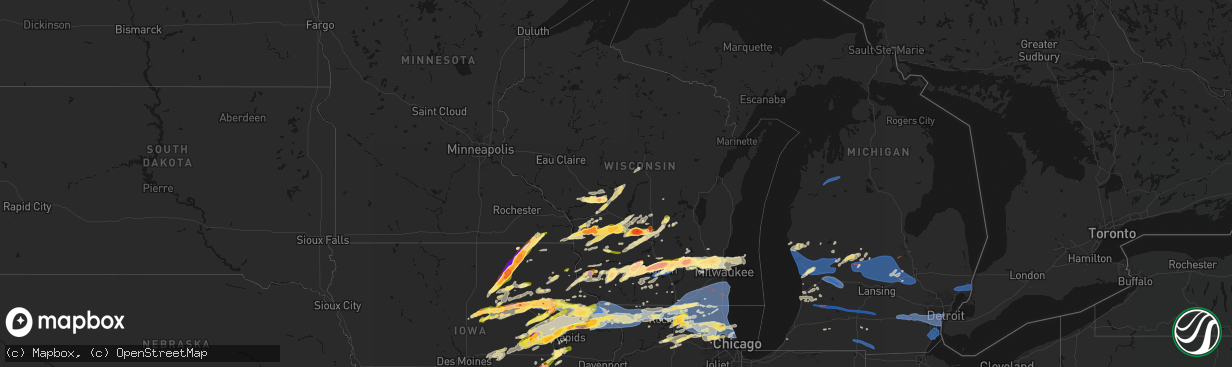
Hail
Tornado
Wind
195,169
Estimated number of impacted properties by a 1.00" hail or larger76,998
Estimated number of impacted properties by a 1.75" hail or larger83,190
Estimated number of impacted properties by a 2.50" hail or largerStorm reports in Wisconsin
Wisconsin
| Date | Description |
|---|---|
| 04/14/20266:59 PM CDT | A local report indicates 1.00 inch wind near 2 SSE Germantown |
| 04/14/20266:55 PM CDT | A local report indicates 1.25 inch wind near 3 SSE Germantown |
| 04/14/20266:54 PM CDT | A local report indicates 70 MPH wind near 3 W Sinsinawa |
| 04/14/20266:47 PM CDT | A local report indicates 1.00 inch wind near Germantown |
| 04/14/20266:47 PM CDT | Report from mping: quarter |
| 04/14/20266:46 PM CDT | Report from mping: ping pong ball |
| 04/14/20266:41 PM CDT | Photo from social media with coins. Time estimated from radar. |
| 04/14/20266:40 PM CDT | Report from mping: quarter |
| 04/14/20266:38 PM CDT | Photo from social media with a tape measure. Time estimate from radar. |
| 04/14/20266:38 PM CDT | Photo from social media with a tape measure. |
| 04/14/20266:38 PM CDT | A local report indicates 1.25 inch wind near 3 S Richfield |
| 04/14/20266:31 PM CDT | Trained spotter measures softball sized hail near maple bluff. |
| 04/14/20266:30 PM CDT | Report from mping: quarter |
| 04/14/20266:28 PM CDT | Time estimated by radar. |
| 04/14/20266:28 PM CDT | Corrects previous tornado report date and time from 4 ssw endeavor. Nws storm survey found ef1 tornado damage southwest of endeavor. Brief tornado had a 50 yard wide pa |
| 04/14/20266:27 PM CDT | Radar confirmed tornadic debris signature at this location. Multiple roofs ripped off a commercial facility reported by law enforcement. Siding damage to nearby church. |
| 04/14/20266:25 PM CDT | Report from mping: baseball |
| 04/14/20266:24 PM CDT | Trained spotter reports 2 inch diameter hail in endeavor. |
| 04/14/20266:22 PM CDT | Nws storm survey found ef2 tornado damage in the town of lisbon. Maximum winds 120 mph. Path length 3.2 miles. Duration 6 minutes. Complete loss of roof on southern sid |
| 04/14/20266:20 PM CDT | Trained spotter reports thunderstorm wind damage. |
| 04/14/20266:20 PM CDT | Time estimated by radar. |
| 04/14/20266:19 PM CDT | Verified via photo with coins from social media. |
| 04/14/20266:17 PM CDT | Photo provided via social media. |
| 04/14/20266:16 PM CDT | A local report indicates 1.00 inch wind near Hartland |
| 04/14/20266:12 PM CDT | Photo from social media with a quarter for comparison. |
| 04/14/20266:06 PM CDT | Report from mping: quarter |
| 04/14/20266:01 PM CDT | Report from mping: ping pong ball |
| 04/14/20266:00 PM CDT | Report from mping: quarter |
| 04/14/20266:00 PM CDT | A local report indicates 3.00 inch wind near 4 SSW Plainville |
| 04/14/20265:57 PM CDT | A local report indicates 2.75 inch wind near 2 SE Watertown |
| 04/14/20265:56 PM CDT | Report from mping: quarter |
| 04/14/20265:55 PM CDT | A local report indicates 1.00 inch wind near 6 ENE Wonewoc |
| 04/14/20265:52 PM CDT | Report from mping: hen egg |
| 04/14/20265:52 PM CDT | A local report indicates 1.75 inch wind near Watertown |
| 04/14/20265:50 PM CDT | Photo from social media with a quarter for comparison. |
| 04/14/20265:49 PM CDT | Report from mping: quarter |
| 04/14/20265:49 PM CDT | Report from mping: half dollar |
| 04/14/20265:48 PM CDT | Report from mping: golf ball |
| 04/14/20265:48 PM CDT | Report from mping: quarter |
| 04/14/20265:47 PM CDT | Report from mping: quarter |
| 04/14/20265:45 PM CDT | Report from mping: tennis ball |
| 04/14/20265:44 PM CDT | Report from mping: golf ball |
| 04/14/20265:40 PM CDT | A local report indicates 1.75 inch wind near Cobb |
| 04/14/20265:39 PM CDT | Report from mping: baseball+ |
| 04/14/20265:38 PM CDT | A local report indicates 1.75 inch wind near 1 SSE Hillsboro |
| 04/14/20265:37 PM CDT | A local report indicates 1.25 inch wind near Coon Valley |
| 04/14/20265:37 PM CDT | Corrects previous hail report from 3 e maple bluff. Trained spotter reports measured hail stones as large as 3.5 inches in diameter. |
| 04/14/20265:37 PM CDT | Radar confirmed tornado with debris signature. House destroyed on raese rd northwest of union center. The tornado was reported to continue northeast crossing state high |
| 04/14/20265:37 PM CDT | Report from mping: hen egg+ |
| 04/14/20265:35 PM CDT | A local report indicates 2.50 inch wind near Cottage Grove |
| 04/14/20265:34 PM CDT | Report from mping: golf ball |
| 04/14/20265:34 PM CDT | A local report indicates 1.00 inch wind near Patch Grove |
| 04/14/20265:34 PM CDT | A local report indicates 1.00 inch wind near 3 W Hillsboro |
| 04/14/20265:34 PM CDT | Report from mping: tea cup |
| 04/14/20265:33 PM CDT | Report from mping: hen egg |
| 04/14/20265:33 PM CDT | The tornado begin in rural areas west-northwest of union center continuing northeast for almost 9 miles. The worst damage... Rated lower ef3 with winds to 140 mph... Wa |
| 04/14/20265:32 PM CDT | Report from mping: golf ball |
| 04/14/20265:31 PM CDT | Report from mping: quarter |
| 04/14/20265:30 PM CDT | Report from mping: quarter |
| 04/14/20265:29 PM CDT | Report from mping: hen egg |
| 04/14/20265:27 PM CDT | Report from mping: half dollar |
| 04/14/20265:27 PM CDT | Report from mping: ping pong ball |
| 04/14/20265:27 PM CDT | Report from mping: quarter |
| 04/14/20265:26 PM CDT | Report from mping: golf ball |
| 04/14/20265:26 PM CDT | A local report indicates 1.00 inch wind near 1 SW Sun Prairie |
| 04/14/20265:25 PM CDT | A local report indicates 3.00 inch wind near 1 ESE Maple Bluff |
| 04/14/20265:25 PM CDT | A local report indicates a tornado near 5 E Mount Hope |
| 04/14/20265:24 PM CDT | A local report indicates 2.50 inch wind near 3 E Maple Bluff |
| 04/14/20265:23 PM CDT | Report from mping: half dollar |
| 04/14/20265:23 PM CDT | Report from mping: half dollar |
| 04/14/20265:22 PM CDT | Trained spotter measures 2 inch diameter hail. |
| 04/14/20265:20 PM CDT | Photo from social media. |
| 04/14/20265:20 PM CDT | A local report indicates 2.75 inch wind near 1 SE Maple Bluff |
| 04/14/20265:19 PM CDT | Report from mping: ping pong ball |
| 04/14/20265:18 PM CDT | Report from mping: baseball |
| 04/14/20265:17 PM CDT | Report from mping: quarter |
| 04/14/20265:17 PM CDT | Report from mping: quarter |
| 04/14/20265:15 PM CDT | Picture provided via social media. |
| 04/14/20265:14 PM CDT | Report from mping: quarter |
| 04/14/20265:13 PM CDT | Report from mping: quarter |
| 04/14/20265:13 PM CDT | Report from mping: quarter |
| 04/14/20265:10 PM CDT | Report from mping: quarter |
| 04/14/20265:09 PM CDT | Report from mping: hen egg |
| 04/14/20265:07 PM CDT | Report from mping: ping pong ball |
| 04/14/20265:07 PM CDT | Report from mping: quarter |
| 04/14/20265:07 PM CDT | A local report indicates 2.00 inch wind near 2 S Marshall |
| 04/14/20265:06 PM CDT | Report from mping: hen egg |
| 04/14/20265:05 PM CDT | A local report indicates 1.00 inch wind near 3 NE Mount Hope |
| 04/14/20265:02 PM CDT | A local report indicates 3.00 inch wind near 1 NW Maple Bluff |
| 04/14/20265:02 PM CDT | A local report indicates 1.50 inch wind near Middleton |
| 04/14/20265:00 PM CDT | A local report indicates 1.00 inch wind near 2 N Maple Bluff |
| 04/14/20265:00 PM CDT | Trained spotter reports hail stones up to 2 inches in diameter. |
| 04/14/20265:00 PM CDT | A local report indicates 1.00 inch wind near 1 SE Maple Bluff |
| 04/14/20264:59 PM CDT | A local report indicates 2.00 inch wind near 3 NE Middleton |
| 04/14/20264:58 PM CDT | Report from mping: golf ball |
| 04/14/20264:57 PM CDT | Report from mping: half dollar |
| 04/14/20264:57 PM CDT | A local report indicates 2.75 inch wind near 3 SW Cashton |
| 04/14/20264:55 PM CDT | Report from mping: golf ball |
| 04/14/20264:55 PM CDT | A local report indicates 2.50 inch wind near Middleton |
| 04/14/20264:55 PM CDT | Report from mping: ping pong ball |
| 04/14/20264:55 PM CDT | Report from mping: quarter |
| 04/14/20264:54 PM CDT | Report from mping: ping pong ball |
| 04/14/20264:54 PM CDT | Report from mping: quarter |
| 04/14/20264:52 PM CDT | A local report indicates 2.00 inch wind near 2 S Middleton |
| 04/14/20264:51 PM CDT | Windshields broken on patrol car. |
| 04/14/20264:50 PM CDT | Report from mping: quarter |
| 04/14/20264:49 PM CDT | Report from mping: half dollar |
| 04/14/20264:49 PM CDT | Report from mping: half dollar |
| 04/14/20264:49 PM CDT | A local report indicates 1.25 inch wind near 3 NE Deerfield |
| 04/14/20264:49 PM CDT | Report from mping: half dollar |
| 04/14/20264:47 PM CDT | A local report indicates 1.00 inch wind near Deerfield |
| 04/14/20264:46 PM CDT | A local report indicates 1.75 inch wind near 1 WNW Esofea |
| 04/14/20264:45 PM CDT | Trained spotter measures hail stones as large as 2.75 inches in diameter. |
| 04/14/20264:45 PM CDT | Photo provided via social media. |
| 04/14/20264:45 PM CDT | Photo from social media with a quarter for comparison. |
| 04/14/20264:44 PM CDT | A local report indicates 1.75 inch wind near 1 W Middleton |
| 04/14/20264:39 PM CDT | Report from mping: quarter |
| 04/14/20264:38 PM CDT | One hail stone of 2 inch diameter. |
| 04/14/20264:38 PM CDT | A local report indicates 2.50 inch wind near 1 E Mazomanie |
| 04/14/20264:36 PM CDT | Baseball sized hail falling causing significant damage to siding and roofs in the area. |
| 04/14/20264:34 PM CDT | Report from mping: quarter |
| 04/14/20264:33 PM CDT | Report from mping: quarter |
| 04/14/20264:31 PM CDT | A local report indicates 1.75 inch wind near 4 W Black Earth |
| 04/14/20264:29 PM CDT | A local report indicates 2.00 inch wind near 5 SE Arena |
| 04/14/20264:25 PM CDT | A local report indicates 1.00 inch wind near 4 ENE Genoa |
| 04/14/20264:23 PM CDT | Report from mping: quarter |
| 04/14/20264:21 PM CDT | A local report indicates 1.50 inch wind near 2 W Barneveld |
| 04/14/20264:17 PM CDT | A local report indicates 1.00 inch wind near Barneveld |
| 04/14/20263:52 PM CDT | A local report indicates 1.00 inch wind near 2 NE Mineral Point |
| 04/13/20269:04 PM CDT | A local report indicates 1.00 inch wind near 4 S Gillingham |
| 04/13/20268:38 PM CDT | Trained spotter reports uprooted trees in addition to shingle & chimney damage. |
| 04/13/20268:29 PM CDT | Nws storm survey found ef1 tornado damage southwest of east troy. Maximum winds of 100 mph. |
| 04/13/20267:55 PM CDT | Trained spotter estimates 70 mph winds. |
| 04/13/20267:48 PM CDT | Trained spotter reports broken tree branches and limbs. |
| 04/13/20267:29 PM CDT | Trained spotter reports baseball-sized hail. Multiple vehicles with broken glass. |
| 04/13/20267:19 PM CDT | Report from mping: hen egg |
| 04/13/20267:07 PM CDT | Trained spotter estimates baseball sized hail. |
| 04/13/20267:02 PM CDT | Report from mping: quarter |
| 04/13/20267:02 PM CDT | Report from mping: hen egg+ |
| 04/13/20267:00 PM CDT | Trained spotter estimates 70 mph winds. |
All States Impacted by Hail Map on April 14, 2026
Cities Impacted by Hail Map on April 14, 2026
- Mannsville, NY
- Sandy Creek, NY
- Lacona, NY
- Adams, NY
- Lorraine, NY
- Taberg, NY
- West Leyden, NY
- Radcliffe, IA
- Ellsworth, IA
- Hubbard, IA
- Eldora, IA
- Iowa Falls, IA
- Seymour, TX
- Munday, TX
- Steamboat Rock, IA
- Wellsburg, IA
- Grundy Center, IA
- Parkersburg, IA
- Monticello, IN
- Ramey, PA
- Clinton, IN
- Houtzdale, PA
- Dana, IN
- Holland, IA
- Dike, IA
- Idaville, IN
- Burnettsville, IN
- Montezuma, IN
- Bloomingdale, IN
- Hillsdale, IN
- Electra, TX
- Monon, IN
- Rensselaer, IN
- Crawfordsville, IN
- Darlington, IN
- Ladoga, IN
- New Ross, IN
- Ackley, IA
- Geneva, IA
- Bristow, IA
- Dumont, IA
- Allison, IA
- Reinbeck, IA
- Cedar Falls, IA
- Greene, IA
- Delphi, IN
- Oelwein, IA
- Logansport, IN
- Royal Center, IN
- Shell Rock, IA
- Maynard, IA
- Fayette, IA
- Wadena, IA
- New Hartford, IA
- Jamestown, IN
- Elgin, IA
- Dodgeville, WI
- Advance, IN
- Lebanon, IN
- Waterloo, IA
- Clarksville, IA
- Lucerne, IN
- Twelve Mile, IN
- Iowa Park, TX
- Plainfield, IA
- Kewanna, IN
- Rochester, IN
- Flora, IN
- Bringhurst, IN
- Ridgeway, WI
- Mineral Point, WI
- Janesville, IA
- Camden, IN
- Bowerston, OH
- Caledonia, MN
- Galveston, IN
- Walton, IN
- Westgate, IA
- Comstock, TX
- Young America, IN
- Kokomo, IN
- Barneveld, WI
- Charles City, IA
- Nashua, IA
- Blue Mounds, WI
- Stoddard, WI
- Chaseburg, WI
- Genoa, WI
- Viroqua, WI
- Queensbury, NY
- Glens Falls, NY
- Lake George, NY
- Salem, NY
- Fort Edward, NY
- Argyle, NY
- Granville, NY
- Lake Luzerne, NY
- Hartford, NY
- Fort Ann, NY
- Hudson Falls, NY
- Evansdale, IA
- Whitestown, IN
- Waverly, IA
- Black Earth, WI
- Burkburnett, TX
- Dewar, IA
- Dorset, VT
- West Rupert, VT
- Grandfield, OK
- Mount Horeb, WI
- Harrold, TX
- Mentone, IN
- Jewett, OH
- Cadiz, OH
- Scio, OH
- Paducah, TX
- Carrollton, OH
- Tippecanoe, IN
- Readlyn, IA
- Denver, IA
- Raymond, IA
- Bunker Hill, IN
- Brownsville, MN
- Arena, WI
- Mazomanie, WI
- Dunkerton, IA
- Warsaw, IN
- Etna Green, IN
- Ionia, IA
- Westby, WI
- Coon Valley, WI
- Independence, IA
- Jesup, IA
- Manchester Center, VT
- Arlington, VT
- New Hampton, IA
- Alta Vista, IA
- Middleton, WI
- Madison, WI
- Verona, WI
- Del Rio, TX
- Girard, TX
- Spur, TX
- West Union, IA
- Conrad, IA
- Cross Plains, WI
- Hopedale, OH
- Oran, IA
- Fairbank, IA
- Cashton, WI
- Devol, OK
- Clermont, IA
- Norwalk, WI
- Claypool, IN
- Peru, IN
- Akron, IN
- Onward, IN
- Greentown, IN
- Hazleton, IA
- Amboy, IN
- Elma, IA
- Converse, IN
- Sumner, IA
- Tripoli, IA
- Waunakee, WI
- Ottumwa, IA
- Blakesburg, IA
- Randlett, OK
- Edgewood, IA
- Elkport, IA
- Garrison, IA
- Silver Lake, IN
- Crowell, TX
- New Providence, IA
- Zearing, IA
- Chelsea, IA
- Swayzee, IN
- Marion, IN
- Hudson, IA
- Jayton, TX
- Cottage Grove, WI
- Deerfield, WI
- Marshall, WI
- Waterloo, WI
- Mcfarland, WI
- Stoughton, WI
- Oregon, WI
- Wabash, IN
- Bangor, WI
- Rockland, WI
- La Farge, WI
- Cambridge, WI
- Keystone, IA
- Marengo, IA
- Gilbertville, IA
- La Porte City, IA
- Sparta, WI
- Brooklyn, IA
- Hartwick, IA
- Sweetser, IN
- Monona, IA
- Burket, IN
- Childress, TX
- Bagley, WI
- Bloomington, WI
- Prairie Du Chien, WI
- Snyder, TX
- Aspermont, TX
- Union, IA
- Brandon, IA
- Vinton, IA
- Mount Auburn, IA
- Ontario, WI
- Hedrick, IA
- Rowley, IA
- Urbana, IA
- Walker, IA
- Center Point, IA
- Aurora, IA
- Winthrop, IA
- Sun Prairie, WI
- Deforest, WI
- Lodi, WI
- Garnavillo, IA
- Garber, IA
- Guttenberg, IA
- Belle Plaine, IA
- Elberon, IA
- Vining, IA
- Blairstown, IA
- Rayland, OH
- Mingo Junction, OH
- Mount Hope, WI
- Hillsboro, WI
- Amsterdam, OH
- Woodman, WI
- La Fontaine, IN
- Watertown, WI
- Van Horne, IA
- Sayre, OK
- Stanley, IA
- Arlington, IA
- Van Buren, IN
- Lake Mills, WI
- Johnson Creek, WI
- Patch Grove, WI
- Unionville, IA
- Moravia, IA
- Cresco, IA
- Lime Springs, IA
- Gas City, IN
- Masonville, IA
- Lamont, IA
- Quasqueton, IA
- Reeseville, WI
- Tomah, WI
- Agency, IA
- Batavia, IA
- Elk City, OK
- Ollie, IA
- Martinsburg, IA
- Luzerne, IA
- Kendall, WI
- Glen Haven, WI
- Platteville, WI
- Livingston, WI
- Temple, OK
- Walters, OK
- Melrose, WI
- Ettrick, WI
- Black River Falls, WI
- Seymour, IA
- Centerville, IA
- Jefferson, WI
- Newhall, IA
- Shellsburg, IA
- Atkins, IA
- Dundee, IA
- Manchester, IA
- Eitzen, MN
- Amana, IA
- Norway, IA
- Fairfax, IA
- Walford, IA
- Elroy, WI
- Pendleton, IN
- Wonewoc, WI
- Watkins, IA
- Sigourney, IA
- Hayesville, IA
- Harper, IA
- Keota, IA
- South English, IA
- Wellman, IA
- Canton, MN
- Harmony, MN
- Packwood, IA
- Fairfield, IA
- Hartford City, IN
- Mauston, WI
- Springville, IA
- Cedar Rapids, IA
- Anamosa, IA
- Marion, IA
- Mount Vernon, IA
- Vernon, TX
- Montpelier, IN
- Earlville, IA
- Coggon, IA
- Delaware, IA
- Delhi, IA
- Ryan, IA
- Kalona, IA
- Parnell, IA
- Central City, IA
- Fennimore, WI
- Iowa City, IA
- Boscobel, WI
- Richland, IA
- Brighton, IA
- Harpers Ferry, IA
- Lyndon Station, WI
- Wisconsin Dells, WI
- La Valle, WI
- Reedsburg, WI
- Helenville, WI
- Wilton, WI
- Butler, OK
- Ixonia, WI
- Comanche, OK
- Duncan, OK
- Upland, IN
- Monaca, PA
- Aliquippa, PA
- Industry, PA
- Shippingport, PA
- Warren, IN
- Warrens, WI
- Canute, OK
- Portland, IN
- Bryant, IN
- Dalton, WI
- Montello, WI
- Portage, WI
- Pardeeville, WI
- Gould, OK
- Dillonvale, OH
- Pennville, IN
- Cobb, WI
- Highland, WI
- Montfort, WI
- Muscoda, WI
- Bloomingdale, OH
- Adena, OH
- Sewickley, PA
- Ambridge, PA
- Leetsdale, PA
- Rewey, WI
- Linden, WI
- Palo, IA
- Toddville, IA
- Vinson, OK
- Dysart, IA
- Gladbrook, IA
- Beaman, IA
- Whitten, IA
- Morrison, IA
- Hopkinton, IA
- Quanah, TX
- Keystone, IN
- Dunkirk, IN
- Geneva, IN
- Lancaster, WI
- Georgetown, PA
- Midland, PA
- Mabel, MN
- Clinton, OK
- Carter, OK
- Willow, OK
- Decatur, IN
- McGregor, IA
- Jonesboro, IN
- Huntington, IN
- Aplington, IA
- Ely, IA
- Martelle, IA
- Oxford, IA
- Coralville, IA
- Center Junction, IA
- Monticello, IA
- Lebanon, WI
- Solon, IA
- Oconomowoc, WI
- Ashippun, WI
- Lanesboro, MN
- Colesburg, IA
- Fort Recovery, OH
- Duke, OK
- Preston, MN
- Markesan, WI
- Avoca, WI
- Spring Green, WI
- Babcock, WI
- Pittsville, WI
- Neosho, WI
- Hartland, WI
- Sullivan, WI
- Hartford, WI
- Foss, OK
- Old Glory, TX
- Rubicon, WI
- Dyersville, IA
- Worthington, IA
- Mendon, OH
- Rockford, OH
- Robins, IA
- Alburnett, IA
- Hiawatha, IA
- Bluffton, IN
- Markle, IN
- Coldwater, OH
- Rushford, MN
- Peterson, MN
- Okauchee, WI
- Nashotah, WI
- Colgate, WI
- Washington, IA
- Wayland, IA
- Mount Pleasant, IA
- West Branch, IA
- Sussex, WI
- Tipton, IA
- Mechanicsville, IA
- Olustee, OK
- Mangum, OK
- Blair, OK
- Altus, OK
- Saint Henry, OH
- Grand Marsh, WI
- Oxford, WI
- Wapakoneta, OH
- Saint Marys, OH
- Briggsville, WI
- Stitzer, WI
- Princeton, WI
- Cascade, IA
- Farley, IA
- Westfield, WI
- Wisconsin Rapids, WI
- Onslow, IA
- Marlow, OK
- Endeavor, WI
- Arapaho, OK
- Celina, OH
- Salamonia, IN
- Spencerville, OH
- Epworth, IA
- Hordville, NE
- Polk, NE
- Adams, WI
- Delafield, WI
- Hubertus, WI
- Menomonee Falls, WI
- Pewaukee, WI
- Brookfield, WI
- Lannon, WI
- Peosta, IA
- Bernard, IA
- Dubuque, IA
- Crawfordsville, IA
- Columbus Junction, IA
- Winfield, IA
- Butler, WI
- Germantown, WI
- Venedocia, OH
- Delphos, OH
- Lima, OH
- Milwaukee, WI
- Maquoketa, IA
- Monmouth, IA
- Baldwin, IA
- Harrod, OH
- Wyoming, IA
- New Bremen, OH
- Montezuma, OH
- Minster, OH
- Maria Stein, OH
- Chickasaw, OH
- New Knoxville, OH
- Anna, OH
- Zionsville, IN
- Houston, MN
- Mount Blanchard, OH
- Bucyrus, OH
- Neshkoro, WI
- Richfield, WI
- Mequon, WI
- Davidson, OK
- La Motte, IA
- Zwingle, IA
- Bellevue, IA
- Leesburg, IN
- North Webster, IN
- Lone Wolf, OK
- Hobart, OK
- Roosevelt, OK
- Columbus City, IA
- Letts, IA
- Wapello, IA
- Hazel Green, WI
- East Dubuque, IL
- Andrew, IA
- Plymouth, OH
- Shelby, OH
- Tiro, OH
- Juneau, WI
- Bloomville, OH
- New Washington, OH
- Botkins, OH
- Oklaunion, TX
- Shiloh, OH
- Ripon, WI
- Green Lake, WI
- Stanton, TX
- Belleville, WI
- Wales, WI
- Waukesha, WI
- Junction City, WI
- Shelby, NE
- Galena, IL
- Milladore, WI
- Attica, OH
- Grandview, IA
- Miles, IA
- Hanover, IL
- Sabula, IA
- Savanna, IL
- Spragueville, IA
- Elizabeth, IL
- Stockton, IL
- Scales Mound, IL
- Apple River, IL
- Cuba City, WI
- Shullsburg, WI
- Willard, OH
- Frederick, OK
- New Glarus, WI
- Blanchardville, WI
- Hollandale, WI
- Brooklyn, WI
- Lawton, OK
- Monticello, WI
- Muscatine, IA
- New Boston, IL
- Hollister, OK
- Whitehall, MI
- Chatfield, OH
- Tipton, OK
- Preston, IA
- McConnell, IL
- Shannon, IL
- Kent, IL
- Lena, IL
- Pearl City, IL
- Mount Carroll, IL
- Lanark, IL
- Freeport, IL
- Holton, MI
- Twin Lake, MI
- Evansville, WI
- Fort Sill, OK
- Montague, MI
- Loveland, OK
- Albany, WI
- Chattanooga, OK
- Indiahoma, OK
- Cache, OK
- Cedarville, IL
- Dakota, IL
- Rothbury, MI
- Edgerton, WI
- Gail, TX
- Holy Cross, IA
- Elgin, OK
- Rocksprings, TX
- Faxon, OK
- Geronimo, OK
- Midland, TX
- Fremont, MI
- Ridott, IL
- Pecatonica, IL
- Davis, IL
- Rock City, IL
- Fletcher, OK
- Rush Springs, OK
- Newaygo, MI
- Wauzeka, WI
- East Troy, WI
- Burlington, WI
- Waterford, WI
- Genoa City, WI
- Twin Lakes, WI
- Franksville, WI
- Union Grove, WI
- Rochester, WI
- Kansasville, WI
- Readstown, WI
- Rockton, IL
- Rockford, IL
- Winnebago, IL
- White Cloud, MI
- Belding, MI
- Greenville, MI
- Rockford, MI
- Cedar Springs, MI
- Howard City, MI
- Morley, MI
- Salem, WI
- Caledonia, WI
- Oak Creek, WI
- Muskego, WI
- Richmond, IL
- Franklin, WI
- Spring Grove, IL
- Silver Lake, WI
- Wilmot, WI
- Antioch, IL
- Bristol, WI
- Trevor, WI
- Sturtevant, WI
- Racine, WI
- Fox Lake, IL
- Ninnekah, OK
- Muskegon, MI
- Capron, IL
- Poplar Grove, IL
- Roscoe, IL
- Sharon, WI
- Springfield, WI
- Caledonia, IL
- Clinton, WI
- Beloit, WI
- Darien, WI
- Garden Prairie, IL
- Williams Bay, WI
- Durand, IL
- South Beloit, IL
- Delavan, WI
- Fontana, WI
- Elkhorn, WI
- Belvidere, IL
- Machesney Park, IL
- Loves Park, IL
- Woodstock, IL
- Walworth, WI
- Cherry Valley, IL
- Hebron, IL
- Lake Geneva, WI
- Marengo, IL
- Harvard, IL
- Monroe Center, IL
- Pratt, KS
- Sawyer, KS
- Sidney, MI
- Sheridan, MI
- Viola, WI
- German Valley, IL
- Baileyville, IL
- Pierson, MI
- Nickerson, KS
- Hutchinson, KS
- New Vienna, IA
- West Olive, MI
- Grand Haven, MI
- Gowen, MI
- Davis Junction, IL
- Wonder Lake, IL
- Turon, KS
- Spring Lake, MI
- Stafford, KS
- Fruitport, MI
- Nunica, MI
- Coopersville, MI
- Ravenna, MI
- Kenosha, WI
- Bradley, OK
- Lindsay, OK
- Prague, OK
- Paden, OK
- Kent City, MI
- Casnovia, MI
- Conklin, MI
- Sylvia, KS
- Mchenry, IL
- Crystal Lake, IL
- Ingleside, IL
- Fox River Grove, IL
- Wauconda, IL
- Grayslake, IL
- Cary, IL
- Ringwood, IL
- Island Lake, IL
- Huntley, IL
- Barrington, IL
- Round Lake, IL
- Lake Villa, IL
- Lake In The Hills, IL
- Union, IL
- Sparta, MI
- Leakey, TX
- Allendale, MI
- Pleasant Prairie, WI
- Lake Zurich, IL
- Gurnee, IL
- Mundelein, IL
- Zion, IL
- Wadsworth, IL
- Libertyville, IL
- Stanton, MI
- Vestaburg, MI
- Riverdale, MI
- Richland Center, WI
- Kirkland, IL
- Ashton, IL
- Franklin Grove, IL
- Edmore, MI
- Riceville, IA
- Grand Rapids, MI
- Marne, MI
- Plevna, KS
- Sycamore, IL
- Kingston, IL
- Genoa, IL
- Hampshire, IL
- Burlington, IL
- Gilberts, IL
- Algonquin, IL
- Dundee, IL
- Carpentersville, IL
- Abbyville, KS
- Rochelle, IL
- Crystal, MI
- Comstock Park, MI
- Belmont, MI
- Sand Lake, MI
- Elgin, IL
- Waukegan, IL
- Winthrop Harbor, IL
- North Chicago, IL
- Vernon Hills, IL
- Ada, MI
- Sterling, KS
- Sumner, MI
- Malta, IL
- Lee, IL
- Carson City, MI
- Compton, IL
- Steward, IL
- Ridgeway, IA
- Clare, IL
- Cunningham, KS
- Dekalb, IL
- Tulsa, OK
- Palatine, IL
- Arlington Heights, IL
- Fenwick, MI
- Buffalo Grove, IL
- Hubbardston, MI
- Decorah, IA
- Diller, NE
- Alma, MI
- Lawler, IA
- Hubbell, NE
- Fairbury, NE
- Reynolds, NE
- Ithaca, MI
- Middleton, MI
- New Lisbon, WI
- Friendship, WI
- Mountain Home, TX
- Hoffman Estates, IL
- Esmond, IL
- Cook, NE
- Sterling, NE
- Farmersburg, IA
- Shabbona, IL
- Chana, IL
- Wyoming, MI
- Grandville, MI
- Streamwood, IL
- Bartlett, IL
- Lake Bluff, IL
- South Elgin, IL
- Great Lakes, IL
- Schaumburg, IL
- Lake Forest, IL
- Lincolnshire, IL
- Hanover Park, IL
- Rolling Meadows, IL
- Elk Grove Village, IL
- Medinah, IL
- Roselle, IL
- Bloomingdale, IL
- Glendale Heights, IL
- Addison, IL
- Itasca, IL
- Prospect Heights, IL
- Wheeling, IL
- Deerfield, IL
- Caledonia, MI
- Beatrice, NE
- Maple Park, IL
- Saint Charles, IL
- Cortland, IL
- Stuart, IA
- Dexter, IA
- Northbrook, IL
- Mount Prospect, IL
- Junction, TX
- Crab Orchard, NE
- Filley, NE
- Tecumseh, NE
- Talmage, NE
- Nebraska City, NE
- Muir, MI
- Winslow, IL
- Alto, MI
- Lowell, MI
- Freeport, MI
- Clarksville, MI
- Wetumka, OK
- Waucoma, IA
- Calmar, IA
- Highland Park, IL
- Glencoe, IL
- Lake Odessa, MI
- Broken Arrow, OK
- Coweta, OK
- Bixby, OK
- Mounds, OK
- Glenpool, OK
- Jenks, OK
- Sapulpa, OK
- Kiefer, OK
- Inola, OK
- Catoosa, OK
- Claremore, OK
- Okemah, OK
- Weleetka, OK
- Concordia, KS
- Scandia, KS
- Wayne, IL
- West Chicago, IL
- Dunbar, NE
- Lorton, NE
- Orangeville, IL
- Monroe, WI
- Winnetka, IL
- Blue River, WI
- Glen Elder, KS
- Zeeland, MI
- Bensenville, IL
- Wood Dale, IL
- Cawker City, KS
- Baden, PA
- Ionia, MI
- Orleans, MI
- Fowler, MI
- Pewamo, MI
- Westphalia, MI
- Lyons, MI
- Des Plaines, IL
- Perrinton, MI
- Ashley, MI
- Saint Johns, MI
- Maple Rapids, MI
- Pompeii, MI
- North Star, MI
- Wheeler, MI
- Saint Charles, MI
- Ovid, MI
- Elsie, MI
- Brant, MI
- Bannister, MI
- Courtland, KS
- Carol Stream, IL
- Fennville, MI
- Narka, KS
- Belleville, KS
- Munden, KS
- Norway, KS
- Glenview, IL
- Jansen, NE
- Lynnville, IA
- Hamilton, MI
- Hudsonville, MI
- Dorr, MI
- Holland, MI
- Byron Center, MI
- Mankato, KS
- Owosso, MI
- Corunna, MI
- Percival, IA
- Harwood Heights, IL
- Schiller Park, IL
- Lincolnwood, IL
- Niles, IL
- Skokie, IL
- Chicago, IL
- Park Ridge, IL
- Beloit, KS
- Randall, KS
- Allegan, MI
- Durand, MI
- Douglas, MI
- Saugatuck, MI
- Grinnell, IA
- Newton, IA
- Byars, OK
- Wanette, OK
- Dewitt, MI
- Oakley, MI
- Perry, MI
- Henderson, MI
- Laingsburg, MI
- Adams, NE
- Morrice, MI
- Chesaning, MI
- Bancroft, MI
- Hamburg, IA
- Sidney, IA
- Otsego, MI
- Riverton, IA
- Plainwell, MI
- Big Spring, TX
- New Lothrop, MI
- Lennon, MI
- Vernon, MI
- Golf, IL
- Morton Grove, IL
- Wilmette, IL
- Highwood, IL
- Farragut, IA
- Swartz Creek, MI
- Gaines, MI
- Byron, MI
- Ferryville, WI
- Soldiers Grove, WI
- Wild Rose, WI
- Jewell, KS
- Essex, IA
- Imogene, IA
- Endicott, NE
- Cuba, KS
- Formoso, KS
- Mahaska, KS
- Haddam, KS
- Rock Springs, WI
- North Freedom, WI
- Loganville, WI
- Winfield, IL
- Evanston, IL
- Kellogg, IA
- Brock, NE
- Victor, IA
- Plain, WI
- Hillpoint, WI
- Hopkins, MI
- Virginia, NE
- Peru, NE
- Malcom, IA
- Morrowville, KS
- Juda, WI
- Prescott, IA
- Baraboo, WI
- Janesville, WI
- Shenandoah, IA
- Fremont, WI
- Rock Port, MO
- Red Oak, IA
- Weyauwega, WI
- Waupaca, WI
- Clarinda, IA
- Villisca, IA
- Kenilworth, IL
- Cazenovia, WI
- Lime Ridge, WI
- Hollenberg, KS
- Sully, IA
- Vicksburg, MI
- Creston, IA
- Steele City, NE
- Coin, IA
- Schoolcraft, MI
- Prairieburg, IA
- Langworthy, IA
- Stanton, IA
- Wewoka, OK
- Maud, OK
- Seminole, OK
- Brodhead, WI
- Holly, MI
- Fenton, MI
- Flint, MI
- Linden, MI
- Grand Blanc, MI
- Orient, IA
- Nodaway, IA
- Homer, MI
- Tekonsha, MI
- Pickrell, NE
- Blue Springs, NE
- Wymore, NE
- Odell, NE
- Corning, IA
- Carbon, IA
- Burchard, NE
- Winterset, IA
- Ladora, IA
- Liberty, NE
- Steinauer, NE
- Holdenville, OK
- Laughlin Afb, TX
- Brackettville, TX
- Elk Creek, NE
- Prole, IA
- Lewiston, NE
- Greenfield, IA
- Swisher, IA
- Patterson, IA
- Henryetta, OK
- Okmulgee, OK
- Lisbon, IA
- Windsor, WI
- Cyril, OK
- Cement, OK
- Saint Charles, IA
- North Liberty, IA
- Tiffin, IA
- Muskogee, OK
- Webbers Falls, OK
- Warner, OK
- Gore, OK
- Vian, OK
- Stilwell, OK
- Tahlequah, OK
- Welling, OK
- Lorimor, IA
- Chickasha, OK
- Proctor, OK
- Westville, OK
- Lincoln, AR
- Summers, AR
- Canehill, AR
- Fayetteville, AR
- Prairie Grove, AR
- Farmington, AR
- Springdale, AR
- Hindsville, AR
- Huntsville, AR
- Elkins, AR
- Rogers, AR
- Eureka Springs, AR
- Berryville, AR
- North English, IA
- New Virginia, IA
- Indianola, IA
- Ann Arbor, MI
- Dexter, MI
- Chelsea, MI
- Grass Lake, MI
- Ypsilanti, MI
- Whitmore Lake, MI
- Plymouth, MI
- Canton, MI
- Belleville, MI
- Inkster, MI
- Romulus, MI
- Dearborn Heights, MI
- Wayne, MI
- Dearborn, MI
- Westland, MI
- Garden City, MI
- Noble, OK
- Lexington, OK
- Williamsburg, IA
- Milo, IA
- Baroda, MI
- Bridgman, MI
- Riverside, IA
- Taylor, MI
- Detroit, MI
- Trenton, MI
- Lincoln Park, MI
- Southgate, MI
- Allen Park, MI
- Wyandotte, MI
- Grosse Ile, MI
- Riverview, MI
- River Rouge, MI
- Melvindale, MI
- Ecorse, MI
- Forreston, IL
- Leaf River, IL
- Hills, IA
- Delta, IA
- Eddyville, IA
- Cedar, IA
- Fremont, IA
- Kirkville, IA
- Lindenwood, IL
- Castle, OK
- Bristow, OK
- Boley, OK
- Greeley, IA
- Beggs, OK
- Olds, IA
- Lenox, IA
- D Hanis, TX
- Hondo, TX
- Mesick, MI
- Afton, IA
- Kingsley, MI
- Buckley, MI
- Manton, MI
- Fife Lake, MI
- Johnstown, OH
- Alexandria, OH
- Pataskala, OH
- Granville, OH
- McClelland, IA
- Minden, IA
- Pickett, WI
- Omro, WI
- Jackson, WI
- Cedarburg, WI
- West Bend, WI
- Cassville, WI
- Potosi, WI
- Waterville, IA
- Postville, IA
- Luana, IA
- Waukon, IA
- Marquette, IA
- Cambria, WI
- Poynette, WI
- Packwaukee, WI
- Saint Olaf, IA
- Sherrill, IA
- Rushsylvania, OH
- Bellefontaine, OH
- Zanesfield, OH
- West Mansfield, OH
- Dublin, NH
- Marlborough, NH
- Harrisville, NH
- Keene, NH
- Coeymans Hollow, NY
- Clarksville, NY
- Selkirk, NY
- Ravena, NY
- Voorheesville, NY
- Westerlo, NY
- Feura Bush, NY
- Delmar, NY
- Alcove, NY
- South Bethlehem, NY
- Castleton On Hudson, NY
- Schodack Landing, NY
- Glenmont, NY
- Nassau, NY
- Pittsfield, MA
- Colwell, IA
- Coldwater, MI
- Quincy, MI
- Marble Rock, IA
- Hillsdale, MI
- Reading, MI
- Oktaha, OK
- Fort Gibson, OK
- Bella Vista, AR
- Cave Springs, AR
- Gravette, AR
- Noel, MO
- Jay, OK
- Gentry, AR
- Hiwasse, AR
- Anderson, MO
- Garfield, AR
- Watts, OK
- Decatur, AR
- Centerton, AR
- Lowell, AR
- Bentonville, AR
- Powell, MO
- Maysville, AR
- Pineville, MO
- Colcord, OK
- Washburn, MO
- Sulphur Springs, AR
- Seligman, MO
- Siloam Springs, AR
- Pea Ridge, AR
- South West City, MO
- Olivet, MI
- Springport, MI
- Albion, MI
- Delton, MI
- Battle Creek, MI
- Hickory Corners, MI
- Marshall, MI
- Bellevue, MI
- Augusta, MI
- Parma, MI
- Dowling, MI
- East China, MI
- Marine City, MI
- New Haven, MI
- Casco, MI
- Saint Clair, MI
- Frankenmuth, MI
- Bridgeport, MI
- Rockwood, MI
- Carleton, MI
- Newport, MI
- South Rockwood, MI
- Monroe, MI
- Flat Rock, MI
- Park Hill, OK


