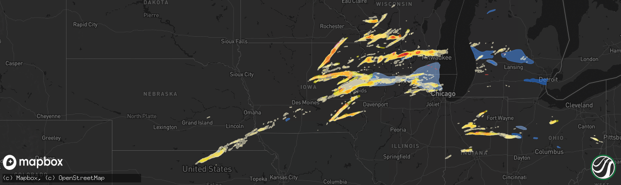
Hail Map in Iowa on April 14, 2026
The weather event in Iowa on April 14, 2026 includes Hail, Tornado, and Wind maps. 18 states and 1,229 cities were impacted and suffered possible damage. The total estimated number of properties impacted is 197,208.
Hail
Tornado
Wind
197,208
Estimated number of impacted properties by a 1.00" hail or larger71,161
Estimated number of impacted properties by a 1.75" hail or larger45,053
Estimated number of impacted properties by a 2.50" hail or largerStorm reports in Iowa
Iowa
| Date | Description |
|---|---|
| 04/14/20266:50 PM CDT | Photo provided. Time estimated using radar. |
| 04/14/20266:49 PM CDT | Report from mping: ping pong ball |
| 04/14/20266:48 PM CDT | A local report indicates 1.00 inch wind near 4 SE Langworthy |
| 04/14/20266:41 PM CDT | Asos. |
| 04/14/20266:32 PM CDT | Small tree branches/ limbs down. |
| 04/14/20266:30 PM CDT | Possible tornado. |
| 04/14/20266:30 PM CDT | Storm chaser report. Time estimated from radar. |
| 04/14/20266:29 PM CDT | A local report indicates 2.00 inch wind near Noble |
| 04/14/20266:27 PM CDT | Efu tornado confirmed based on multiple chaser videos and spotter reports. No known damage along its estimated 2.6 mile path. Tornado path determined by radar and video |
| 04/14/20266:27 PM CDT | Tree debris in the road. Possible tornado. |
| 04/14/20266:21 PM CDT | A local report indicates 1.00 inch wind near 3 NW Center Junction |
| 04/14/20266:21 PM CDT | Report from mping: ping pong ball |
| 04/14/20266:18 PM CDT | A local report indicates 1.00 inch wind near 2 SSE Hudson |
| 04/14/20266:17 PM CDT | A local report indicates 1.00 inch wind near 1 WSW Langworthy |
| 04/14/20266:12 PM CDT | Report from mping: quarter |
| 04/14/20266:12 PM CDT | A local report indicates 1.25 inch wind near 1 W Iowa City |
| 04/14/20266:11 PM CDT | A local report indicates 1.00 inch wind near 1 NNE Iowa City |
| 04/14/20266:10 PM CDT | Report from mping: half dollar |
| 04/14/20266:08 PM CDT | Time estimated from radar. |
| 04/14/20266:06 PM CDT | Quarter sized hail reported by butler county ema north of parkersburg. |
| 04/14/20266:02 PM CDT | Report from mping: quarter |
| 04/14/20266:00 PM CDT | Significant damage to farm buildings and wooden stakes impaled into the ground. |
| 04/14/20265:55 PM CDT | Lots of trees down and flagpoles folded in half. Time estimated from radar. |
| 04/14/20265:54 PM CDT | Time estimated by radar. |
| 04/14/20265:53 PM CDT | Emergency manager reported damage to a machine shed near delhi. Tornado possible. |
| 04/14/20265:52 PM CDT | Report from mping: quarter |
| 04/14/20265:51 PM CDT | Report from mping: quarter |
| 04/14/20265:50 PM CDT | A local report indicates 1.50 inch wind near 2 NNE Marion |
| 04/14/20265:48 PM CDT | Report from mping: quarter |
| 04/14/20265:48 PM CDT | Em report from jesup. Time estimated from radar. |
| 04/14/20265:48 PM CDT | Public report relayed by law enforcement. Time estimated from radar. |
| 04/14/20265:47 PM CDT | Report from mping: quarter |
| 04/14/20265:45 PM CDT | Trained spotter report. Time estimated from radar. |
| 04/14/20265:43 PM CDT | A local report indicates 1.00 inch wind near 3 SW Marion |
| 04/14/20265:40 PM CDT | Trained spotter report. Time estimated from radar. |
| 04/14/20265:37 PM CDT | Time estimated using radar. |
| 04/14/20265:35 PM CDT | A local report indicates 1.75 inch wind near 2 ENE Cedar Rapids |
| 04/14/20265:33 PM CDT | Report from mping: quarter |
| 04/14/20265:31 PM CDT | Report from mping: quarter |
| 04/14/20265:30 PM CDT | Emergency manager reported damage to a building near masonville. Tornado possible. |
| 04/14/20265:29 PM CDT | Report from mping: half dollar |
| 04/14/20265:28 PM CDT | Report from mping: golf ball |
| 04/14/20265:26 PM CDT | A local report indicates 1.75 inch wind near 2 S Fairfax |
| 04/14/20265:25 PM CDT | A local report indicates 2.00 inch wind near Van Horne |
| 04/14/20265:24 PM CDT | Report from mping: quarter |
| 04/14/20265:23 PM CDT | Report from mping: half dollar |
| 04/14/20265:22 PM CDT | Time estimated from radar. |
| 04/14/20265:16 PM CDT | A local report indicates 1.00 inch wind near Urbana |
| 04/14/20265:15 PM CDT | Time estimated via radar. |
| 04/14/20265:11 PM CDT | A local report indicates 1.00 inch wind near 2 ESE Mount Auburn |
| 04/14/20265:09 PM CDT | A local report indicates 1.00 inch wind near 1 SW Vinton |
| 04/14/20265:09 PM CDT | A local report indicates 2.75 inch wind near Elma |
| 04/14/20265:09 PM CDT | Report from mping: half dollar |
| 04/14/20265:08 PM CDT | A local report indicates 1.75 inch wind near 3 N Ottumwa |
| 04/14/20265:08 PM CDT | Sheet metal roofs ripped off near walmart in independence. Tornado possible. |
| 04/14/20265:06 PM CDT | Time estimated from radar. |
| 04/14/20265:06 PM CDT | Occurring right now and coming down real good. |
| 04/14/20265:05 PM CDT | A local report indicates 1.75 inch wind near 1 WNW Alta Vista |
| 04/14/20265:05 PM CDT | A local report indicates 1.75 inch wind near 1 N Independence |
| 04/14/20265:02 PM CDT | Image from buchanan county emergency manager in nws chat. Time estimated from radar. |
| 04/14/20264:58 PM CDT | A local report indicates 1.00 inch wind near 2 ENE Ottumwa |
| 04/14/20264:56 PM CDT | A local report indicates 3.50 inch wind near Elma |
| 04/14/20264:54 PM CDT | A local report indicates 1.00 inch wind near 5 SW New Providence |
| 04/14/20264:54 PM CDT | A local report indicates 1.00 inch wind near Tripoli |
| 04/14/20264:50 PM CDT | A local report indicates 2.50 inch wind near 3 ENE Floyd |
| 04/14/20264:40 PM CDT | Image frrom county emergency management on nws chat. |
| 04/14/20264:40 PM CDT | A local report indicates 3.25 inch wind near 1 E Charles City |
| 04/14/20264:38 PM CDT | Report from mping: quarter |
| 04/14/20264:35 PM CDT | A local report indicates 1.75 inch wind near 3 N Raymond |
| 04/14/20264:34 PM CDT | A local report indicates 2.00 inch wind near 1 SSE Cedar Falls |
| 04/14/20264:30 PM CDT | Golf ball to baseball. |
| 04/14/20264:29 PM CDT | A local report indicates 2.00 inch wind near 1 SW Waterloo |
| 04/14/20264:25 PM CDT | A local report indicates 1.75 inch wind near 7 W Nashua |
| 04/14/20264:24 PM CDT | Estimated in comparison to tennis ball. Time estimated from radar. |
| 04/14/20264:21 PM CDT | A local report indicates 1.75 inch wind near 1 ENE Waterloo |
| 04/14/20264:15 PM CDT | A local report indicates 1.00 inch wind near 1 WSW Cedar Falls |
| 04/14/20264:14 PM CDT | A local report indicates 1.75 inch wind near Greene |
| 04/14/20264:12 PM CDT | A local report indicates 1.00 inch wind near 1 W Cedar Falls |
| 04/14/20264:11 PM CDT | Time estimated via radar. |
| 04/14/20264:00 PM CDT | A local report indicates 1.00 inch wind near Dike |
| 04/14/20263:58 PM CDT | Trained spotter reported quarter sized hail falling in bristow at this time. |
| 04/14/20263:58 PM CDT | Relayed by em. |
| 04/14/20263:40 PM CDT | A local report indicates 1.75 inch wind near 1 NW Holland |
| 04/14/20263:26 PM CDT | Report from mping: golf ball |
| 04/14/20263:20 PM CDT | Emergency management relayed reports of a brief tornado touchdown just south of eldora with damage to a building. |
| 04/14/20263:20 PM CDT | Time and location estimated from radar. |
| 04/14/20263:10 PM CDT | A local report indicates 1.50 inch wind near Eldora |
| 04/14/20262:42 AM CDT | A local report indicates 60 MPH wind near 4 SE Kirkville |
| 04/14/202612:40 AM CDT | A local report indicates 60 MPH wind near Creston |
| 04/13/202611:33 PM CDT | Also torrential rainfall causing minor street flooding. |
| 04/13/202611:27 PM CDT | Delayed report from emergency management of hail up to one inch in diameter in essex... Iowa. |
| 04/13/20267:15 PM CDT | A local report indicates 1.00 inch wind near Bellevue |
All States Impacted by Hail Map on April 14, 2026
Cities Impacted by Hail Map on April 14, 2026
- Mannsville, NY
- Sandy Creek, NY
- Lacona, NY
- Adams, NY
- Lorraine, NY
- Taberg, NY
- West Leyden, NY
- Radcliffe, IA
- Ellsworth, IA
- Hubbard, IA
- Eldora, IA
- Iowa Falls, IA
- Seymour, TX
- Munday, TX
- Steamboat Rock, IA
- Wellsburg, IA
- Grundy Center, IA
- Parkersburg, IA
- Monticello, IN
- Ramey, PA
- Clinton, IN
- Houtzdale, PA
- Dana, IN
- Holland, IA
- Dike, IA
- Idaville, IN
- Burnettsville, IN
- Montezuma, IN
- Bloomingdale, IN
- Hillsdale, IN
- Electra, TX
- Monon, IN
- Rensselaer, IN
- Crawfordsville, IN
- Darlington, IN
- Ladoga, IN
- New Ross, IN
- Ackley, IA
- Geneva, IA
- Bristow, IA
- Dumont, IA
- Allison, IA
- Reinbeck, IA
- Cedar Falls, IA
- Greene, IA
- Delphi, IN
- Oelwein, IA
- Logansport, IN
- Royal Center, IN
- Shell Rock, IA
- Maynard, IA
- Fayette, IA
- Wadena, IA
- New Hartford, IA
- Jamestown, IN
- Elgin, IA
- Dodgeville, WI
- Advance, IN
- Lebanon, IN
- Waterloo, IA
- Clarksville, IA
- Lucerne, IN
- Twelve Mile, IN
- Iowa Park, TX
- Plainfield, IA
- Kewanna, IN
- Rochester, IN
- Flora, IN
- Bringhurst, IN
- Ridgeway, WI
- Mineral Point, WI
- Janesville, IA
- Camden, IN
- Bowerston, OH
- Caledonia, MN
- Galveston, IN
- Walton, IN
- Westgate, IA
- Comstock, TX
- Young America, IN
- Kokomo, IN
- Barneveld, WI
- Charles City, IA
- Nashua, IA
- Blue Mounds, WI
- Stoddard, WI
- Chaseburg, WI
- Genoa, WI
- Viroqua, WI
- Queensbury, NY
- Glens Falls, NY
- Lake George, NY
- Salem, NY
- Fort Edward, NY
- Argyle, NY
- Granville, NY
- Lake Luzerne, NY
- Hartford, NY
- Fort Ann, NY
- Hudson Falls, NY
- Evansdale, IA
- Whitestown, IN
- Waverly, IA
- Black Earth, WI
- Burkburnett, TX
- Dewar, IA
- Dorset, VT
- West Rupert, VT
- Grandfield, OK
- Mount Horeb, WI
- Harrold, TX
- Mentone, IN
- Jewett, OH
- Cadiz, OH
- Scio, OH
- Paducah, TX
- Carrollton, OH
- Tippecanoe, IN
- Readlyn, IA
- Denver, IA
- Raymond, IA
- Bunker Hill, IN
- Brownsville, MN
- Arena, WI
- Mazomanie, WI
- Dunkerton, IA
- Warsaw, IN
- Etna Green, IN
- Ionia, IA
- Westby, WI
- Coon Valley, WI
- Independence, IA
- Jesup, IA
- Manchester Center, VT
- Arlington, VT
- New Hampton, IA
- Alta Vista, IA
- Middleton, WI
- Madison, WI
- Verona, WI
- Del Rio, TX
- Girard, TX
- Spur, TX
- West Union, IA
- Conrad, IA
- Cross Plains, WI
- Hopedale, OH
- Oran, IA
- Fairbank, IA
- Cashton, WI
- Devol, OK
- Clermont, IA
- Norwalk, WI
- Claypool, IN
- Peru, IN
- Akron, IN
- Onward, IN
- Greentown, IN
- Hazleton, IA
- Amboy, IN
- Elma, IA
- Converse, IN
- Sumner, IA
- Tripoli, IA
- Waunakee, WI
- Ottumwa, IA
- Blakesburg, IA
- Randlett, OK
- Edgewood, IA
- Elkport, IA
- Garrison, IA
- Silver Lake, IN
- Crowell, TX
- New Providence, IA
- Zearing, IA
- Chelsea, IA
- Swayzee, IN
- Marion, IN
- Hudson, IA
- Jayton, TX
- Cottage Grove, WI
- Deerfield, WI
- Marshall, WI
- Waterloo, WI
- Mcfarland, WI
- Stoughton, WI
- Oregon, WI
- Wabash, IN
- Bangor, WI
- Rockland, WI
- La Farge, WI
- Cambridge, WI
- Keystone, IA
- Marengo, IA
- Gilbertville, IA
- La Porte City, IA
- Sparta, WI
- Brooklyn, IA
- Hartwick, IA
- Sweetser, IN
- Monona, IA
- Burket, IN
- Childress, TX
- Bagley, WI
- Bloomington, WI
- Prairie Du Chien, WI
- Snyder, TX
- Aspermont, TX
- Union, IA
- Brandon, IA
- Vinton, IA
- Mount Auburn, IA
- Ontario, WI
- Hedrick, IA
- Rowley, IA
- Urbana, IA
- Walker, IA
- Center Point, IA
- Aurora, IA
- Winthrop, IA
- Sun Prairie, WI
- Deforest, WI
- Lodi, WI
- Garnavillo, IA
- Garber, IA
- Guttenberg, IA
- Belle Plaine, IA
- Elberon, IA
- Vining, IA
- Blairstown, IA
- Rayland, OH
- Mingo Junction, OH
- Mount Hope, WI
- Hillsboro, WI
- Amsterdam, OH
- Woodman, WI
- La Fontaine, IN
- Watertown, WI
- Van Horne, IA
- Sayre, OK
- Stanley, IA
- Arlington, IA
- Van Buren, IN
- Lake Mills, WI
- Johnson Creek, WI
- Patch Grove, WI
- Unionville, IA
- Moravia, IA
- Cresco, IA
- Lime Springs, IA
- Gas City, IN
- Masonville, IA
- Lamont, IA
- Quasqueton, IA
- Reeseville, WI
- Tomah, WI
- Agency, IA
- Batavia, IA
- Elk City, OK
- Ollie, IA
- Martinsburg, IA
- Luzerne, IA
- Kendall, WI
- Glen Haven, WI
- Platteville, WI
- Livingston, WI
- Temple, OK
- Walters, OK
- Melrose, WI
- Ettrick, WI
- Black River Falls, WI
- Seymour, IA
- Centerville, IA
- Jefferson, WI
- Newhall, IA
- Shellsburg, IA
- Atkins, IA
- Dundee, IA
- Manchester, IA
- Eitzen, MN
- Amana, IA
- Norway, IA
- Fairfax, IA
- Walford, IA
- Elroy, WI
- Pendleton, IN
- Wonewoc, WI
- Watkins, IA
- Sigourney, IA
- Hayesville, IA
- Harper, IA
- Keota, IA
- South English, IA
- Wellman, IA
- Canton, MN
- Harmony, MN
- Packwood, IA
- Fairfield, IA
- Hartford City, IN
- Mauston, WI
- Springville, IA
- Cedar Rapids, IA
- Anamosa, IA
- Marion, IA
- Mount Vernon, IA
- Vernon, TX
- Montpelier, IN
- Earlville, IA
- Coggon, IA
- Delaware, IA
- Delhi, IA
- Ryan, IA
- Kalona, IA
- Parnell, IA
- Central City, IA
- Fennimore, WI
- Iowa City, IA
- Boscobel, WI
- Richland, IA
- Brighton, IA
- Harpers Ferry, IA
- Lyndon Station, WI
- Wisconsin Dells, WI
- La Valle, WI
- Reedsburg, WI
- Helenville, WI
- Wilton, WI
- Butler, OK
- Ixonia, WI
- Comanche, OK
- Duncan, OK
- Upland, IN
- Monaca, PA
- Aliquippa, PA
- Industry, PA
- Shippingport, PA
- Warren, IN
- Warrens, WI
- Canute, OK
- Portland, IN
- Bryant, IN
- Dalton, WI
- Montello, WI
- Portage, WI
- Pardeeville, WI
- Gould, OK
- Dillonvale, OH
- Pennville, IN
- Cobb, WI
- Highland, WI
- Montfort, WI
- Muscoda, WI
- Bloomingdale, OH
- Adena, OH
- Sewickley, PA
- Ambridge, PA
- Leetsdale, PA
- Rewey, WI
- Linden, WI
- Palo, IA
- Toddville, IA
- Vinson, OK
- Dysart, IA
- Gladbrook, IA
- Beaman, IA
- Whitten, IA
- Morrison, IA
- Hopkinton, IA
- Quanah, TX
- Keystone, IN
- Dunkirk, IN
- Geneva, IN
- Lancaster, WI
- Georgetown, PA
- Midland, PA
- Mabel, MN
- Clinton, OK
- Carter, OK
- Willow, OK
- Decatur, IN
- McGregor, IA
- Jonesboro, IN
- Huntington, IN
- Aplington, IA
- Ely, IA
- Martelle, IA
- Oxford, IA
- Coralville, IA
- Center Junction, IA
- Monticello, IA
- Lebanon, WI
- Solon, IA
- Oconomowoc, WI
- Ashippun, WI
- Lanesboro, MN
- Colesburg, IA
- Fort Recovery, OH
- Duke, OK
- Preston, MN
- Markesan, WI
- Avoca, WI
- Spring Green, WI
- Babcock, WI
- Pittsville, WI
- Neosho, WI
- Hartland, WI
- Sullivan, WI
- Hartford, WI
- Foss, OK
- Old Glory, TX
- Rubicon, WI
- Dyersville, IA
- Worthington, IA
- Mendon, OH
- Rockford, OH
- Robins, IA
- Alburnett, IA
- Hiawatha, IA
- Bluffton, IN
- Markle, IN
- Coldwater, OH
- Rushford, MN
- Peterson, MN
- Okauchee, WI
- Nashotah, WI
- Colgate, WI
- Washington, IA
- Wayland, IA
- Mount Pleasant, IA
- West Branch, IA
- Sussex, WI
- Tipton, IA
- Mechanicsville, IA
- Olustee, OK
- Mangum, OK
- Blair, OK
- Altus, OK
- Saint Henry, OH
- Grand Marsh, WI
- Oxford, WI
- Wapakoneta, OH
- Saint Marys, OH
- Briggsville, WI
- Stitzer, WI
- Princeton, WI
- Cascade, IA
- Farley, IA
- Westfield, WI
- Wisconsin Rapids, WI
- Onslow, IA
- Marlow, OK
- Endeavor, WI
- Arapaho, OK
- Celina, OH
- Salamonia, IN
- Spencerville, OH
- Epworth, IA
- Hordville, NE
- Polk, NE
- Adams, WI
- Delafield, WI
- Hubertus, WI
- Menomonee Falls, WI
- Pewaukee, WI
- Brookfield, WI
- Lannon, WI
- Peosta, IA
- Bernard, IA
- Dubuque, IA
- Crawfordsville, IA
- Columbus Junction, IA
- Winfield, IA
- Butler, WI
- Germantown, WI
- Venedocia, OH
- Delphos, OH
- Lima, OH
- Milwaukee, WI
- Maquoketa, IA
- Monmouth, IA
- Baldwin, IA
- Harrod, OH
- Wyoming, IA
- New Bremen, OH
- Montezuma, OH
- Minster, OH
- Maria Stein, OH
- Chickasaw, OH
- New Knoxville, OH
- Anna, OH
- Zionsville, IN
- Houston, MN
- Mount Blanchard, OH
- Bucyrus, OH
- Neshkoro, WI
- Richfield, WI
- Mequon, WI
- Davidson, OK
- La Motte, IA
- Zwingle, IA
- Bellevue, IA
- Leesburg, IN
- North Webster, IN
- Lone Wolf, OK
- Hobart, OK
- Roosevelt, OK
- Columbus City, IA
- Letts, IA
- Wapello, IA
- Hazel Green, WI
- East Dubuque, IL
- Andrew, IA
- Plymouth, OH
- Shelby, OH
- Tiro, OH
- Juneau, WI
- Bloomville, OH
- New Washington, OH
- Botkins, OH
- Oklaunion, TX
- Shiloh, OH
- Ripon, WI
- Green Lake, WI
- Stanton, TX
- Belleville, WI
- Wales, WI
- Waukesha, WI
- Junction City, WI
- Shelby, NE
- Galena, IL
- Milladore, WI
- Attica, OH
- Grandview, IA
- Miles, IA
- Hanover, IL
- Sabula, IA
- Savanna, IL
- Spragueville, IA
- Elizabeth, IL
- Stockton, IL
- Scales Mound, IL
- Apple River, IL
- Cuba City, WI
- Shullsburg, WI
- Willard, OH
- Frederick, OK
- New Glarus, WI
- Blanchardville, WI
- Hollandale, WI
- Brooklyn, WI
- Lawton, OK
- Monticello, WI
- Muscatine, IA
- New Boston, IL
- Hollister, OK
- Whitehall, MI
- Chatfield, OH
- Tipton, OK
- Preston, IA
- McConnell, IL
- Shannon, IL
- Kent, IL
- Lena, IL
- Pearl City, IL
- Mount Carroll, IL
- Lanark, IL
- Freeport, IL
- Holton, MI
- Twin Lake, MI
- Evansville, WI
- Fort Sill, OK
- Montague, MI
- Loveland, OK
- Albany, WI
- Chattanooga, OK
- Indiahoma, OK
- Cache, OK
- Cedarville, IL
- Dakota, IL
- Rothbury, MI
- Edgerton, WI
- Gail, TX
- Holy Cross, IA
- Elgin, OK
- Rocksprings, TX
- Faxon, OK
- Geronimo, OK
- Midland, TX
- Fremont, MI
- Ridott, IL
- Pecatonica, IL
- Davis, IL
- Rock City, IL
- Fletcher, OK
- Rush Springs, OK
- Newaygo, MI
- Wauzeka, WI
- East Troy, WI
- Burlington, WI
- Waterford, WI
- Genoa City, WI
- Twin Lakes, WI
- Franksville, WI
- Union Grove, WI
- Rochester, WI
- Kansasville, WI
- Readstown, WI
- Rockton, IL
- Rockford, IL
- Winnebago, IL
- White Cloud, MI
- Belding, MI
- Greenville, MI
- Rockford, MI
- Cedar Springs, MI
- Howard City, MI
- Morley, MI
- Salem, WI
- Caledonia, WI
- Oak Creek, WI
- Muskego, WI
- Richmond, IL
- Franklin, WI
- Spring Grove, IL
- Silver Lake, WI
- Wilmot, WI
- Antioch, IL
- Bristol, WI
- Trevor, WI
- Sturtevant, WI
- Racine, WI
- Fox Lake, IL
- Ninnekah, OK
- Muskegon, MI
- Capron, IL
- Poplar Grove, IL
- Roscoe, IL
- Sharon, WI
- Springfield, WI
- Caledonia, IL
- Clinton, WI
- Beloit, WI
- Darien, WI
- Garden Prairie, IL
- Williams Bay, WI
- Durand, IL
- South Beloit, IL
- Delavan, WI
- Fontana, WI
- Elkhorn, WI
- Belvidere, IL
- Machesney Park, IL
- Loves Park, IL
- Woodstock, IL
- Walworth, WI
- Cherry Valley, IL
- Hebron, IL
- Lake Geneva, WI
- Marengo, IL
- Harvard, IL
- Monroe Center, IL
- Pratt, KS
- Sawyer, KS
- Sidney, MI
- Sheridan, MI
- Viola, WI
- German Valley, IL
- Baileyville, IL
- Pierson, MI
- Nickerson, KS
- Hutchinson, KS
- New Vienna, IA
- West Olive, MI
- Grand Haven, MI
- Gowen, MI
- Davis Junction, IL
- Wonder Lake, IL
- Turon, KS
- Spring Lake, MI
- Stafford, KS
- Fruitport, MI
- Nunica, MI
- Coopersville, MI
- Ravenna, MI
- Kenosha, WI
- Bradley, OK
- Lindsay, OK
- Prague, OK
- Paden, OK
- Kent City, MI
- Casnovia, MI
- Conklin, MI
- Sylvia, KS
- Mchenry, IL
- Crystal Lake, IL
- Ingleside, IL
- Fox River Grove, IL
- Wauconda, IL
- Grayslake, IL
- Cary, IL
- Ringwood, IL
- Island Lake, IL
- Huntley, IL
- Barrington, IL
- Round Lake, IL
- Lake Villa, IL
- Lake In The Hills, IL
- Union, IL
- Sparta, MI
- Leakey, TX
- Allendale, MI
- Pleasant Prairie, WI
- Lake Zurich, IL
- Gurnee, IL
- Mundelein, IL
- Zion, IL
- Wadsworth, IL
- Libertyville, IL
- Stanton, MI
- Vestaburg, MI
- Riverdale, MI
- Richland Center, WI
- Kirkland, IL
- Ashton, IL
- Franklin Grove, IL
- Edmore, MI
- Riceville, IA
- Grand Rapids, MI
- Marne, MI
- Plevna, KS
- Sycamore, IL
- Kingston, IL
- Genoa, IL
- Hampshire, IL
- Burlington, IL
- Gilberts, IL
- Algonquin, IL
- Dundee, IL
- Carpentersville, IL
- Abbyville, KS
- Rochelle, IL
- Crystal, MI
- Comstock Park, MI
- Belmont, MI
- Sand Lake, MI
- Elgin, IL
- Waukegan, IL
- Winthrop Harbor, IL
- North Chicago, IL
- Vernon Hills, IL
- Ada, MI
- Sterling, KS
- Sumner, MI
- Malta, IL
- Lee, IL
- Carson City, MI
- Compton, IL
- Steward, IL
- Ridgeway, IA
- Clare, IL
- Cunningham, KS
- Dekalb, IL
- Tulsa, OK
- Palatine, IL
- Arlington Heights, IL
- Fenwick, MI
- Buffalo Grove, IL
- Hubbardston, MI
- Decorah, IA
- Diller, NE
- Alma, MI
- Lawler, IA
- Hubbell, NE
- Fairbury, NE
- Reynolds, NE
- Ithaca, MI
- Middleton, MI
- New Lisbon, WI
- Friendship, WI
- Mountain Home, TX
- Hoffman Estates, IL
- Esmond, IL
- Cook, NE
- Sterling, NE
- Farmersburg, IA
- Shabbona, IL
- Chana, IL
- Wyoming, MI
- Grandville, MI
- Streamwood, IL
- Bartlett, IL
- Lake Bluff, IL
- South Elgin, IL
- Great Lakes, IL
- Schaumburg, IL
- Lake Forest, IL
- Lincolnshire, IL
- Hanover Park, IL
- Rolling Meadows, IL
- Elk Grove Village, IL
- Medinah, IL
- Roselle, IL
- Bloomingdale, IL
- Glendale Heights, IL
- Addison, IL
- Itasca, IL
- Prospect Heights, IL
- Wheeling, IL
- Deerfield, IL
- Caledonia, MI
- Beatrice, NE
- Maple Park, IL
- Saint Charles, IL
- Cortland, IL
- Stuart, IA
- Dexter, IA
- Northbrook, IL
- Mount Prospect, IL
- Junction, TX
- Crab Orchard, NE
- Filley, NE
- Tecumseh, NE
- Talmage, NE
- Nebraska City, NE
- Muir, MI
- Winslow, IL
- Alto, MI
- Lowell, MI
- Freeport, MI
- Clarksville, MI
- Wetumka, OK
- Waucoma, IA
- Calmar, IA
- Highland Park, IL
- Glencoe, IL
- Lake Odessa, MI
- Broken Arrow, OK
- Coweta, OK
- Bixby, OK
- Mounds, OK
- Glenpool, OK
- Jenks, OK
- Sapulpa, OK
- Kiefer, OK
- Inola, OK
- Catoosa, OK
- Claremore, OK
- Okemah, OK
- Weleetka, OK
- Concordia, KS
- Scandia, KS
- Wayne, IL
- West Chicago, IL
- Dunbar, NE
- Lorton, NE
- Orangeville, IL
- Monroe, WI
- Winnetka, IL
- Blue River, WI
- Glen Elder, KS
- Zeeland, MI
- Bensenville, IL
- Wood Dale, IL
- Cawker City, KS
- Baden, PA
- Ionia, MI
- Orleans, MI
- Fowler, MI
- Pewamo, MI
- Westphalia, MI
- Lyons, MI
- Des Plaines, IL
- Perrinton, MI
- Ashley, MI
- Saint Johns, MI
- Maple Rapids, MI
- Pompeii, MI
- North Star, MI
- Wheeler, MI
- Saint Charles, MI
- Ovid, MI
- Elsie, MI
- Brant, MI
- Bannister, MI
- Courtland, KS
- Carol Stream, IL
- Fennville, MI
- Narka, KS
- Belleville, KS
- Munden, KS
- Norway, KS
- Glenview, IL
- Jansen, NE
- Lynnville, IA
- Hamilton, MI
- Hudsonville, MI
- Dorr, MI
- Holland, MI
- Byron Center, MI
- Mankato, KS
- Owosso, MI
- Corunna, MI
- Percival, IA
- Harwood Heights, IL
- Schiller Park, IL
- Lincolnwood, IL
- Niles, IL
- Skokie, IL
- Chicago, IL
- Park Ridge, IL
- Beloit, KS
- Randall, KS
- Allegan, MI
- Durand, MI
- Douglas, MI
- Saugatuck, MI
- Grinnell, IA
- Newton, IA
- Byars, OK
- Wanette, OK
- Dewitt, MI
- Oakley, MI
- Perry, MI
- Henderson, MI
- Laingsburg, MI
- Adams, NE
- Morrice, MI
- Chesaning, MI
- Bancroft, MI
- Hamburg, IA
- Sidney, IA
- Otsego, MI
- Riverton, IA
- Plainwell, MI
- Big Spring, TX
- New Lothrop, MI
- Lennon, MI
- Vernon, MI
- Golf, IL
- Morton Grove, IL
- Wilmette, IL
- Highwood, IL
- Farragut, IA
- Swartz Creek, MI
- Gaines, MI
- Byron, MI
- Ferryville, WI
- Soldiers Grove, WI
- Wild Rose, WI
- Jewell, KS
- Essex, IA
- Imogene, IA
- Endicott, NE
- Cuba, KS
- Formoso, KS
- Mahaska, KS
- Haddam, KS
- Rock Springs, WI
- North Freedom, WI
- Loganville, WI
- Winfield, IL
- Evanston, IL
- Kellogg, IA
- Brock, NE
- Victor, IA
- Plain, WI
- Hillpoint, WI
- Hopkins, MI
- Virginia, NE
- Peru, NE
- Malcom, IA
- Morrowville, KS
- Juda, WI
- Prescott, IA
- Baraboo, WI
- Janesville, WI
- Shenandoah, IA
- Fremont, WI
- Rock Port, MO
- Red Oak, IA
- Weyauwega, WI
- Waupaca, WI
- Clarinda, IA
- Villisca, IA
- Kenilworth, IL
- Cazenovia, WI
- Lime Ridge, WI
- Hollenberg, KS
- Sully, IA
- Vicksburg, MI
- Creston, IA
- Steele City, NE
- Coin, IA
- Schoolcraft, MI
- Prairieburg, IA
- Langworthy, IA
- Stanton, IA
- Wewoka, OK
- Maud, OK
- Seminole, OK
- Brodhead, WI
- Holly, MI
- Fenton, MI
- Flint, MI
- Linden, MI
- Grand Blanc, MI
- Orient, IA
- Nodaway, IA
- Homer, MI
- Tekonsha, MI
- Pickrell, NE
- Blue Springs, NE
- Wymore, NE
- Odell, NE
- Corning, IA
- Carbon, IA
- Burchard, NE
- Winterset, IA
- Ladora, IA
- Liberty, NE
- Steinauer, NE
- Holdenville, OK
- Laughlin Afb, TX
- Brackettville, TX
- Elk Creek, NE
- Prole, IA
- Lewiston, NE
- Greenfield, IA
- Swisher, IA
- Patterson, IA
- Henryetta, OK
- Okmulgee, OK
- Lisbon, IA
- Windsor, WI
- Cyril, OK
- Cement, OK
- Saint Charles, IA
- North Liberty, IA
- Tiffin, IA
- Muskogee, OK
- Webbers Falls, OK
- Warner, OK
- Gore, OK
- Vian, OK
- Stilwell, OK
- Tahlequah, OK
- Welling, OK
- Lorimor, IA
- Chickasha, OK
- Proctor, OK
- Westville, OK
- Lincoln, AR
- Summers, AR
- Canehill, AR
- Fayetteville, AR
- Prairie Grove, AR
- Farmington, AR
- Springdale, AR
- Hindsville, AR
- Huntsville, AR
- Elkins, AR
- Rogers, AR
- Eureka Springs, AR
- Berryville, AR
- North English, IA
- New Virginia, IA
- Indianola, IA
- Ann Arbor, MI
- Dexter, MI
- Chelsea, MI
- Grass Lake, MI
- Ypsilanti, MI
- Whitmore Lake, MI
- Plymouth, MI
- Canton, MI
- Belleville, MI
- Inkster, MI
- Romulus, MI
- Dearborn Heights, MI
- Wayne, MI
- Dearborn, MI
- Westland, MI
- Garden City, MI
- Noble, OK
- Lexington, OK
- Williamsburg, IA
- Milo, IA
- Baroda, MI
- Bridgman, MI
- Riverside, IA
- Taylor, MI
- Detroit, MI
- Trenton, MI
- Lincoln Park, MI
- Southgate, MI
- Allen Park, MI
- Wyandotte, MI
- Grosse Ile, MI
- Riverview, MI
- River Rouge, MI
- Melvindale, MI
- Ecorse, MI
- Forreston, IL
- Leaf River, IL
- Hills, IA
- Delta, IA
- Eddyville, IA
- Cedar, IA
- Fremont, IA
- Kirkville, IA
- Lindenwood, IL
- Castle, OK
- Bristow, OK
- Boley, OK
- Greeley, IA
- Beggs, OK
- Olds, IA
- Lenox, IA
- D Hanis, TX
- Hondo, TX
- Mesick, MI
- Afton, IA
- Kingsley, MI
- Buckley, MI
- Manton, MI
- Fife Lake, MI
- Johnstown, OH
- Alexandria, OH
- Pataskala, OH
- Granville, OH
- McClelland, IA
- Minden, IA
- Pickett, WI
- Omro, WI
- Jackson, WI
- Cedarburg, WI
- West Bend, WI
- Cassville, WI
- Potosi, WI
- Waterville, IA
- Postville, IA
- Luana, IA
- Waukon, IA
- Marquette, IA
- Cambria, WI
- Poynette, WI
- Packwaukee, WI
- Saint Olaf, IA
- Sherrill, IA
- Rushsylvania, OH
- Bellefontaine, OH
- Zanesfield, OH
- West Mansfield, OH
- Dublin, NH
- Marlborough, NH
- Harrisville, NH
- Keene, NH
- Coeymans Hollow, NY
- Clarksville, NY
- Selkirk, NY
- Ravena, NY
- Voorheesville, NY
- Westerlo, NY
- Feura Bush, NY
- Delmar, NY
- Alcove, NY
- South Bethlehem, NY
- Castleton On Hudson, NY
- Schodack Landing, NY
- Glenmont, NY
- Nassau, NY
- Pittsfield, MA
- Colwell, IA
- Coldwater, MI
- Quincy, MI
- Marble Rock, IA
- Hillsdale, MI
- Reading, MI
- Oktaha, OK
- Fort Gibson, OK
- Bella Vista, AR
- Cave Springs, AR
- Gravette, AR
- Noel, MO
- Jay, OK
- Gentry, AR
- Hiwasse, AR
- Anderson, MO
- Garfield, AR
- Watts, OK
- Decatur, AR
- Centerton, AR
- Lowell, AR
- Bentonville, AR
- Powell, MO
- Maysville, AR
- Pineville, MO
- Colcord, OK
- Washburn, MO
- Sulphur Springs, AR
- Seligman, MO
- Siloam Springs, AR
- Pea Ridge, AR
- South West City, MO
- Olivet, MI
- Springport, MI
- Albion, MI
- Delton, MI
- Battle Creek, MI
- Hickory Corners, MI
- Marshall, MI
- Bellevue, MI
- Augusta, MI
- Parma, MI
- Dowling, MI
- East China, MI
- Marine City, MI
- New Haven, MI
- Casco, MI
- Saint Clair, MI
- Frankenmuth, MI
- Bridgeport, MI
- Rockwood, MI
- Carleton, MI
- Newport, MI
- South Rockwood, MI
- Monroe, MI
- Flat Rock, MI
- Park Hill, OK


