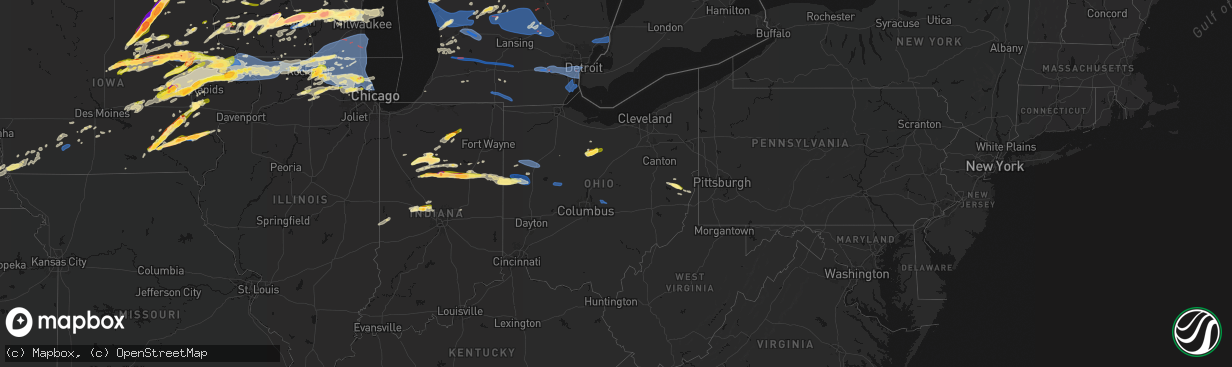
Hail Map in Ohio on April 14, 2026
The weather event in Ohio on April 14, 2026 includes Hail, Tornado, and Wind maps. 18 states and 1,229 cities were impacted and suffered possible damage. The total estimated number of properties impacted is 12,812.
Hail
Tornado
Wind
12,812
Estimated number of impacted properties by a 1.00" hail or larger0
Estimated number of impacted properties by a 1.75" hail or larger0
Estimated number of impacted properties by a 2.50" hail or largerStorm reports in Ohio
Ohio
| Date | Description |
|---|---|
| 04/14/20266:51 PM CDT | . |
| 04/14/20266:40 PM CDT | Poles down on west road. Time estimated from radar. |
| 04/14/20266:40 PM CDT | Poles down on waesch road. Time estimated from radar. |
| 04/14/20266:40 PM CDT | Roof torn off steer barn off sr 364. Time estimated from radar. |
| 04/14/20266:39 PM CDT | Awos station kaoh 2 wnw westminster. |
| 04/14/20266:33 PM CDT | A local report indicates 65 MPH wind near 1 NNE Southworth |
| 04/14/20266:32 PM CDT | Roof and structural damage to separate barns on brockman and harrison and 716a and harrison. Time estimated from radar. |
| 04/14/20266:27 PM CDT | Large tree branches down. Report from social media. Time estimated from radar. |
| 04/14/20264:35 PM CDT | A local report indicates 1.00 inch wind near Hopedale |
| 04/14/20264:35 PM CDT | A local report indicates 1.25 inch wind near Hopedale |
| 04/14/202612:58 PM CDT | Utility pole and wires down. |
| 04/13/20268:37 PM CDT | A tree was snapped along its trunk and blocked the roadway. |
| 04/13/20268:36 PM CDT | Side of barn blown out and barn pushed off foundation. Trailer with iron frame blown on to its side. Trees uprooted and broken along griffith rd. |
| 04/13/20268:29 PM CDT | Numerous trees downed near the intersection of burg street and new burg street. |
| 04/13/20268:28 PM CDT | Photo posted on social media of tree down on power pole. Time estimated from radar. |
| 04/13/20268:24 PM CDT | Public report of property damage including several large trees that were uprooted and a portion of barn roofing blown off. |
| 04/13/20268:15 PM CDT | Numerous trees downed along peter hoover road. Trees onto home. Numerous trees snapped. Time estimated by radar. |
| 04/13/20267:27 PM CDT | A tree was downed across e liberty road near state route 347. |
| 04/13/20267:23 PM CDT | Roof torn off barn. Time estimated from radar. |
| 04/13/20267:22 PM CDT | Corrects previous tstm wnd dmg report from 4 w west mansfield. Power poles snapped at sr47 and county road 12 intersection. Time estimated from radar. |
| 04/13/20267:22 PM CDT | Damage to trees on property. Cement pond damaged. Time estimated from radar. |
| 04/13/20267:21 PM CDT | Tree down on sr47. Time estimated from radar. |
| 04/13/20267:19 PM CDT | Tree down blocking road on county road 26. Time estimated from radar. |
| 04/13/20267:18 PM CDT | Extensive damage to benjamin logan elementary school. Time estimated from radar. |
| 04/13/20267:16 PM CDT | Parked bus flipped and rotated on sr47. Time estimated from radar. |
| 04/13/20267:08 PM CDT | One inch size hail along sr 98. |
All States Impacted by Hail Map on April 14, 2026
Cities Impacted by Hail Map on April 14, 2026
- Mannsville, NY
- Sandy Creek, NY
- Lacona, NY
- Adams, NY
- Lorraine, NY
- Taberg, NY
- West Leyden, NY
- Radcliffe, IA
- Ellsworth, IA
- Hubbard, IA
- Eldora, IA
- Iowa Falls, IA
- Seymour, TX
- Munday, TX
- Steamboat Rock, IA
- Wellsburg, IA
- Grundy Center, IA
- Parkersburg, IA
- Monticello, IN
- Ramey, PA
- Clinton, IN
- Houtzdale, PA
- Dana, IN
- Holland, IA
- Dike, IA
- Idaville, IN
- Burnettsville, IN
- Montezuma, IN
- Bloomingdale, IN
- Hillsdale, IN
- Electra, TX
- Monon, IN
- Rensselaer, IN
- Crawfordsville, IN
- Darlington, IN
- Ladoga, IN
- New Ross, IN
- Ackley, IA
- Geneva, IA
- Bristow, IA
- Dumont, IA
- Allison, IA
- Reinbeck, IA
- Cedar Falls, IA
- Greene, IA
- Delphi, IN
- Oelwein, IA
- Logansport, IN
- Royal Center, IN
- Shell Rock, IA
- Maynard, IA
- Fayette, IA
- Wadena, IA
- New Hartford, IA
- Jamestown, IN
- Elgin, IA
- Dodgeville, WI
- Advance, IN
- Lebanon, IN
- Waterloo, IA
- Clarksville, IA
- Lucerne, IN
- Twelve Mile, IN
- Iowa Park, TX
- Plainfield, IA
- Kewanna, IN
- Rochester, IN
- Flora, IN
- Bringhurst, IN
- Ridgeway, WI
- Mineral Point, WI
- Janesville, IA
- Camden, IN
- Bowerston, OH
- Caledonia, MN
- Galveston, IN
- Walton, IN
- Westgate, IA
- Comstock, TX
- Young America, IN
- Kokomo, IN
- Barneveld, WI
- Charles City, IA
- Nashua, IA
- Blue Mounds, WI
- Stoddard, WI
- Chaseburg, WI
- Genoa, WI
- Viroqua, WI
- Queensbury, NY
- Glens Falls, NY
- Lake George, NY
- Salem, NY
- Fort Edward, NY
- Argyle, NY
- Granville, NY
- Lake Luzerne, NY
- Hartford, NY
- Fort Ann, NY
- Hudson Falls, NY
- Evansdale, IA
- Whitestown, IN
- Waverly, IA
- Black Earth, WI
- Burkburnett, TX
- Dewar, IA
- Dorset, VT
- West Rupert, VT
- Grandfield, OK
- Mount Horeb, WI
- Harrold, TX
- Mentone, IN
- Jewett, OH
- Cadiz, OH
- Scio, OH
- Paducah, TX
- Carrollton, OH
- Tippecanoe, IN
- Readlyn, IA
- Denver, IA
- Raymond, IA
- Bunker Hill, IN
- Brownsville, MN
- Arena, WI
- Mazomanie, WI
- Dunkerton, IA
- Warsaw, IN
- Etna Green, IN
- Ionia, IA
- Westby, WI
- Coon Valley, WI
- Independence, IA
- Jesup, IA
- Manchester Center, VT
- Arlington, VT
- New Hampton, IA
- Alta Vista, IA
- Middleton, WI
- Madison, WI
- Verona, WI
- Del Rio, TX
- Girard, TX
- Spur, TX
- West Union, IA
- Conrad, IA
- Cross Plains, WI
- Hopedale, OH
- Oran, IA
- Fairbank, IA
- Cashton, WI
- Devol, OK
- Clermont, IA
- Norwalk, WI
- Claypool, IN
- Peru, IN
- Akron, IN
- Onward, IN
- Greentown, IN
- Hazleton, IA
- Amboy, IN
- Elma, IA
- Converse, IN
- Sumner, IA
- Tripoli, IA
- Waunakee, WI
- Ottumwa, IA
- Blakesburg, IA
- Randlett, OK
- Edgewood, IA
- Elkport, IA
- Garrison, IA
- Silver Lake, IN
- Crowell, TX
- New Providence, IA
- Zearing, IA
- Chelsea, IA
- Swayzee, IN
- Marion, IN
- Hudson, IA
- Jayton, TX
- Cottage Grove, WI
- Deerfield, WI
- Marshall, WI
- Waterloo, WI
- Mcfarland, WI
- Stoughton, WI
- Oregon, WI
- Wabash, IN
- Bangor, WI
- Rockland, WI
- La Farge, WI
- Cambridge, WI
- Keystone, IA
- Marengo, IA
- Gilbertville, IA
- La Porte City, IA
- Sparta, WI
- Brooklyn, IA
- Hartwick, IA
- Sweetser, IN
- Monona, IA
- Burket, IN
- Childress, TX
- Bagley, WI
- Bloomington, WI
- Prairie Du Chien, WI
- Snyder, TX
- Aspermont, TX
- Union, IA
- Brandon, IA
- Vinton, IA
- Mount Auburn, IA
- Ontario, WI
- Hedrick, IA
- Rowley, IA
- Urbana, IA
- Walker, IA
- Center Point, IA
- Aurora, IA
- Winthrop, IA
- Sun Prairie, WI
- Deforest, WI
- Lodi, WI
- Garnavillo, IA
- Garber, IA
- Guttenberg, IA
- Belle Plaine, IA
- Elberon, IA
- Vining, IA
- Blairstown, IA
- Rayland, OH
- Mingo Junction, OH
- Mount Hope, WI
- Hillsboro, WI
- Amsterdam, OH
- Woodman, WI
- La Fontaine, IN
- Watertown, WI
- Van Horne, IA
- Sayre, OK
- Stanley, IA
- Arlington, IA
- Van Buren, IN
- Lake Mills, WI
- Johnson Creek, WI
- Patch Grove, WI
- Unionville, IA
- Moravia, IA
- Cresco, IA
- Lime Springs, IA
- Gas City, IN
- Masonville, IA
- Lamont, IA
- Quasqueton, IA
- Reeseville, WI
- Tomah, WI
- Agency, IA
- Batavia, IA
- Elk City, OK
- Ollie, IA
- Martinsburg, IA
- Luzerne, IA
- Kendall, WI
- Glen Haven, WI
- Platteville, WI
- Livingston, WI
- Temple, OK
- Walters, OK
- Melrose, WI
- Ettrick, WI
- Black River Falls, WI
- Seymour, IA
- Centerville, IA
- Jefferson, WI
- Newhall, IA
- Shellsburg, IA
- Atkins, IA
- Dundee, IA
- Manchester, IA
- Eitzen, MN
- Amana, IA
- Norway, IA
- Fairfax, IA
- Walford, IA
- Elroy, WI
- Pendleton, IN
- Wonewoc, WI
- Watkins, IA
- Sigourney, IA
- Hayesville, IA
- Harper, IA
- Keota, IA
- South English, IA
- Wellman, IA
- Canton, MN
- Harmony, MN
- Packwood, IA
- Fairfield, IA
- Hartford City, IN
- Mauston, WI
- Springville, IA
- Cedar Rapids, IA
- Anamosa, IA
- Marion, IA
- Mount Vernon, IA
- Vernon, TX
- Montpelier, IN
- Earlville, IA
- Coggon, IA
- Delaware, IA
- Delhi, IA
- Ryan, IA
- Kalona, IA
- Parnell, IA
- Central City, IA
- Fennimore, WI
- Iowa City, IA
- Boscobel, WI
- Richland, IA
- Brighton, IA
- Harpers Ferry, IA
- Lyndon Station, WI
- Wisconsin Dells, WI
- La Valle, WI
- Reedsburg, WI
- Helenville, WI
- Wilton, WI
- Butler, OK
- Ixonia, WI
- Comanche, OK
- Duncan, OK
- Upland, IN
- Monaca, PA
- Aliquippa, PA
- Industry, PA
- Shippingport, PA
- Warren, IN
- Warrens, WI
- Canute, OK
- Portland, IN
- Bryant, IN
- Dalton, WI
- Montello, WI
- Portage, WI
- Pardeeville, WI
- Gould, OK
- Dillonvale, OH
- Pennville, IN
- Cobb, WI
- Highland, WI
- Montfort, WI
- Muscoda, WI
- Bloomingdale, OH
- Adena, OH
- Sewickley, PA
- Ambridge, PA
- Leetsdale, PA
- Rewey, WI
- Linden, WI
- Palo, IA
- Toddville, IA
- Vinson, OK
- Dysart, IA
- Gladbrook, IA
- Beaman, IA
- Whitten, IA
- Morrison, IA
- Hopkinton, IA
- Quanah, TX
- Keystone, IN
- Dunkirk, IN
- Geneva, IN
- Lancaster, WI
- Georgetown, PA
- Midland, PA
- Mabel, MN
- Clinton, OK
- Carter, OK
- Willow, OK
- Decatur, IN
- McGregor, IA
- Jonesboro, IN
- Huntington, IN
- Aplington, IA
- Ely, IA
- Martelle, IA
- Oxford, IA
- Coralville, IA
- Center Junction, IA
- Monticello, IA
- Lebanon, WI
- Solon, IA
- Oconomowoc, WI
- Ashippun, WI
- Lanesboro, MN
- Colesburg, IA
- Fort Recovery, OH
- Duke, OK
- Preston, MN
- Markesan, WI
- Avoca, WI
- Spring Green, WI
- Babcock, WI
- Pittsville, WI
- Neosho, WI
- Hartland, WI
- Sullivan, WI
- Hartford, WI
- Foss, OK
- Old Glory, TX
- Rubicon, WI
- Dyersville, IA
- Worthington, IA
- Mendon, OH
- Rockford, OH
- Robins, IA
- Alburnett, IA
- Hiawatha, IA
- Bluffton, IN
- Markle, IN
- Coldwater, OH
- Rushford, MN
- Peterson, MN
- Okauchee, WI
- Nashotah, WI
- Colgate, WI
- Washington, IA
- Wayland, IA
- Mount Pleasant, IA
- West Branch, IA
- Sussex, WI
- Tipton, IA
- Mechanicsville, IA
- Olustee, OK
- Mangum, OK
- Blair, OK
- Altus, OK
- Saint Henry, OH
- Grand Marsh, WI
- Oxford, WI
- Wapakoneta, OH
- Saint Marys, OH
- Briggsville, WI
- Stitzer, WI
- Princeton, WI
- Cascade, IA
- Farley, IA
- Westfield, WI
- Wisconsin Rapids, WI
- Onslow, IA
- Marlow, OK
- Endeavor, WI
- Arapaho, OK
- Celina, OH
- Salamonia, IN
- Spencerville, OH
- Epworth, IA
- Hordville, NE
- Polk, NE
- Adams, WI
- Delafield, WI
- Hubertus, WI
- Menomonee Falls, WI
- Pewaukee, WI
- Brookfield, WI
- Lannon, WI
- Peosta, IA
- Bernard, IA
- Dubuque, IA
- Crawfordsville, IA
- Columbus Junction, IA
- Winfield, IA
- Butler, WI
- Germantown, WI
- Venedocia, OH
- Delphos, OH
- Lima, OH
- Milwaukee, WI
- Maquoketa, IA
- Monmouth, IA
- Baldwin, IA
- Harrod, OH
- Wyoming, IA
- New Bremen, OH
- Montezuma, OH
- Minster, OH
- Maria Stein, OH
- Chickasaw, OH
- New Knoxville, OH
- Anna, OH
- Zionsville, IN
- Houston, MN
- Mount Blanchard, OH
- Bucyrus, OH
- Neshkoro, WI
- Richfield, WI
- Mequon, WI
- Davidson, OK
- La Motte, IA
- Zwingle, IA
- Bellevue, IA
- Leesburg, IN
- North Webster, IN
- Lone Wolf, OK
- Hobart, OK
- Roosevelt, OK
- Columbus City, IA
- Letts, IA
- Wapello, IA
- Hazel Green, WI
- East Dubuque, IL
- Andrew, IA
- Plymouth, OH
- Shelby, OH
- Tiro, OH
- Juneau, WI
- Bloomville, OH
- New Washington, OH
- Botkins, OH
- Oklaunion, TX
- Shiloh, OH
- Ripon, WI
- Green Lake, WI
- Stanton, TX
- Belleville, WI
- Wales, WI
- Waukesha, WI
- Junction City, WI
- Shelby, NE
- Galena, IL
- Milladore, WI
- Attica, OH
- Grandview, IA
- Miles, IA
- Hanover, IL
- Sabula, IA
- Savanna, IL
- Spragueville, IA
- Elizabeth, IL
- Stockton, IL
- Scales Mound, IL
- Apple River, IL
- Cuba City, WI
- Shullsburg, WI
- Willard, OH
- Frederick, OK
- New Glarus, WI
- Blanchardville, WI
- Hollandale, WI
- Brooklyn, WI
- Lawton, OK
- Monticello, WI
- Muscatine, IA
- New Boston, IL
- Hollister, OK
- Whitehall, MI
- Chatfield, OH
- Tipton, OK
- Preston, IA
- McConnell, IL
- Shannon, IL
- Kent, IL
- Lena, IL
- Pearl City, IL
- Mount Carroll, IL
- Lanark, IL
- Freeport, IL
- Holton, MI
- Twin Lake, MI
- Evansville, WI
- Fort Sill, OK
- Montague, MI
- Loveland, OK
- Albany, WI
- Chattanooga, OK
- Indiahoma, OK
- Cache, OK
- Cedarville, IL
- Dakota, IL
- Rothbury, MI
- Edgerton, WI
- Gail, TX
- Holy Cross, IA
- Elgin, OK
- Rocksprings, TX
- Faxon, OK
- Geronimo, OK
- Midland, TX
- Fremont, MI
- Ridott, IL
- Pecatonica, IL
- Davis, IL
- Rock City, IL
- Fletcher, OK
- Rush Springs, OK
- Newaygo, MI
- Wauzeka, WI
- East Troy, WI
- Burlington, WI
- Waterford, WI
- Genoa City, WI
- Twin Lakes, WI
- Franksville, WI
- Union Grove, WI
- Rochester, WI
- Kansasville, WI
- Readstown, WI
- Rockton, IL
- Rockford, IL
- Winnebago, IL
- White Cloud, MI
- Belding, MI
- Greenville, MI
- Rockford, MI
- Cedar Springs, MI
- Howard City, MI
- Morley, MI
- Salem, WI
- Caledonia, WI
- Oak Creek, WI
- Muskego, WI
- Richmond, IL
- Franklin, WI
- Spring Grove, IL
- Silver Lake, WI
- Wilmot, WI
- Antioch, IL
- Bristol, WI
- Trevor, WI
- Sturtevant, WI
- Racine, WI
- Fox Lake, IL
- Ninnekah, OK
- Muskegon, MI
- Capron, IL
- Poplar Grove, IL
- Roscoe, IL
- Sharon, WI
- Springfield, WI
- Caledonia, IL
- Clinton, WI
- Beloit, WI
- Darien, WI
- Garden Prairie, IL
- Williams Bay, WI
- Durand, IL
- South Beloit, IL
- Delavan, WI
- Fontana, WI
- Elkhorn, WI
- Belvidere, IL
- Machesney Park, IL
- Loves Park, IL
- Woodstock, IL
- Walworth, WI
- Cherry Valley, IL
- Hebron, IL
- Lake Geneva, WI
- Marengo, IL
- Harvard, IL
- Monroe Center, IL
- Pratt, KS
- Sawyer, KS
- Sidney, MI
- Sheridan, MI
- Viola, WI
- German Valley, IL
- Baileyville, IL
- Pierson, MI
- Nickerson, KS
- Hutchinson, KS
- New Vienna, IA
- West Olive, MI
- Grand Haven, MI
- Gowen, MI
- Davis Junction, IL
- Wonder Lake, IL
- Turon, KS
- Spring Lake, MI
- Stafford, KS
- Fruitport, MI
- Nunica, MI
- Coopersville, MI
- Ravenna, MI
- Kenosha, WI
- Bradley, OK
- Lindsay, OK
- Prague, OK
- Paden, OK
- Kent City, MI
- Casnovia, MI
- Conklin, MI
- Sylvia, KS
- Mchenry, IL
- Crystal Lake, IL
- Ingleside, IL
- Fox River Grove, IL
- Wauconda, IL
- Grayslake, IL
- Cary, IL
- Ringwood, IL
- Island Lake, IL
- Huntley, IL
- Barrington, IL
- Round Lake, IL
- Lake Villa, IL
- Lake In The Hills, IL
- Union, IL
- Sparta, MI
- Leakey, TX
- Allendale, MI
- Pleasant Prairie, WI
- Lake Zurich, IL
- Gurnee, IL
- Mundelein, IL
- Zion, IL
- Wadsworth, IL
- Libertyville, IL
- Stanton, MI
- Vestaburg, MI
- Riverdale, MI
- Richland Center, WI
- Kirkland, IL
- Ashton, IL
- Franklin Grove, IL
- Edmore, MI
- Riceville, IA
- Grand Rapids, MI
- Marne, MI
- Plevna, KS
- Sycamore, IL
- Kingston, IL
- Genoa, IL
- Hampshire, IL
- Burlington, IL
- Gilberts, IL
- Algonquin, IL
- Dundee, IL
- Carpentersville, IL
- Abbyville, KS
- Rochelle, IL
- Crystal, MI
- Comstock Park, MI
- Belmont, MI
- Sand Lake, MI
- Elgin, IL
- Waukegan, IL
- Winthrop Harbor, IL
- North Chicago, IL
- Vernon Hills, IL
- Ada, MI
- Sterling, KS
- Sumner, MI
- Malta, IL
- Lee, IL
- Carson City, MI
- Compton, IL
- Steward, IL
- Ridgeway, IA
- Clare, IL
- Cunningham, KS
- Dekalb, IL
- Tulsa, OK
- Palatine, IL
- Arlington Heights, IL
- Fenwick, MI
- Buffalo Grove, IL
- Hubbardston, MI
- Decorah, IA
- Diller, NE
- Alma, MI
- Lawler, IA
- Hubbell, NE
- Fairbury, NE
- Reynolds, NE
- Ithaca, MI
- Middleton, MI
- New Lisbon, WI
- Friendship, WI
- Mountain Home, TX
- Hoffman Estates, IL
- Esmond, IL
- Cook, NE
- Sterling, NE
- Farmersburg, IA
- Shabbona, IL
- Chana, IL
- Wyoming, MI
- Grandville, MI
- Streamwood, IL
- Bartlett, IL
- Lake Bluff, IL
- South Elgin, IL
- Great Lakes, IL
- Schaumburg, IL
- Lake Forest, IL
- Lincolnshire, IL
- Hanover Park, IL
- Rolling Meadows, IL
- Elk Grove Village, IL
- Medinah, IL
- Roselle, IL
- Bloomingdale, IL
- Glendale Heights, IL
- Addison, IL
- Itasca, IL
- Prospect Heights, IL
- Wheeling, IL
- Deerfield, IL
- Caledonia, MI
- Beatrice, NE
- Maple Park, IL
- Saint Charles, IL
- Cortland, IL
- Stuart, IA
- Dexter, IA
- Northbrook, IL
- Mount Prospect, IL
- Junction, TX
- Crab Orchard, NE
- Filley, NE
- Tecumseh, NE
- Talmage, NE
- Nebraska City, NE
- Muir, MI
- Winslow, IL
- Alto, MI
- Lowell, MI
- Freeport, MI
- Clarksville, MI
- Wetumka, OK
- Waucoma, IA
- Calmar, IA
- Highland Park, IL
- Glencoe, IL
- Lake Odessa, MI
- Broken Arrow, OK
- Coweta, OK
- Bixby, OK
- Mounds, OK
- Glenpool, OK
- Jenks, OK
- Sapulpa, OK
- Kiefer, OK
- Inola, OK
- Catoosa, OK
- Claremore, OK
- Okemah, OK
- Weleetka, OK
- Concordia, KS
- Scandia, KS
- Wayne, IL
- West Chicago, IL
- Dunbar, NE
- Lorton, NE
- Orangeville, IL
- Monroe, WI
- Winnetka, IL
- Blue River, WI
- Glen Elder, KS
- Zeeland, MI
- Bensenville, IL
- Wood Dale, IL
- Cawker City, KS
- Baden, PA
- Ionia, MI
- Orleans, MI
- Fowler, MI
- Pewamo, MI
- Westphalia, MI
- Lyons, MI
- Des Plaines, IL
- Perrinton, MI
- Ashley, MI
- Saint Johns, MI
- Maple Rapids, MI
- Pompeii, MI
- North Star, MI
- Wheeler, MI
- Saint Charles, MI
- Ovid, MI
- Elsie, MI
- Brant, MI
- Bannister, MI
- Courtland, KS
- Carol Stream, IL
- Fennville, MI
- Narka, KS
- Belleville, KS
- Munden, KS
- Norway, KS
- Glenview, IL
- Jansen, NE
- Lynnville, IA
- Hamilton, MI
- Hudsonville, MI
- Dorr, MI
- Holland, MI
- Byron Center, MI
- Mankato, KS
- Owosso, MI
- Corunna, MI
- Percival, IA
- Harwood Heights, IL
- Schiller Park, IL
- Lincolnwood, IL
- Niles, IL
- Skokie, IL
- Chicago, IL
- Park Ridge, IL
- Beloit, KS
- Randall, KS
- Allegan, MI
- Durand, MI
- Douglas, MI
- Saugatuck, MI
- Grinnell, IA
- Newton, IA
- Byars, OK
- Wanette, OK
- Dewitt, MI
- Oakley, MI
- Perry, MI
- Henderson, MI
- Laingsburg, MI
- Adams, NE
- Morrice, MI
- Chesaning, MI
- Bancroft, MI
- Hamburg, IA
- Sidney, IA
- Otsego, MI
- Riverton, IA
- Plainwell, MI
- Big Spring, TX
- New Lothrop, MI
- Lennon, MI
- Vernon, MI
- Golf, IL
- Morton Grove, IL
- Wilmette, IL
- Highwood, IL
- Farragut, IA
- Swartz Creek, MI
- Gaines, MI
- Byron, MI
- Ferryville, WI
- Soldiers Grove, WI
- Wild Rose, WI
- Jewell, KS
- Essex, IA
- Imogene, IA
- Endicott, NE
- Cuba, KS
- Formoso, KS
- Mahaska, KS
- Haddam, KS
- Rock Springs, WI
- North Freedom, WI
- Loganville, WI
- Winfield, IL
- Evanston, IL
- Kellogg, IA
- Brock, NE
- Victor, IA
- Plain, WI
- Hillpoint, WI
- Hopkins, MI
- Virginia, NE
- Peru, NE
- Malcom, IA
- Morrowville, KS
- Juda, WI
- Prescott, IA
- Baraboo, WI
- Janesville, WI
- Shenandoah, IA
- Fremont, WI
- Rock Port, MO
- Red Oak, IA
- Weyauwega, WI
- Waupaca, WI
- Clarinda, IA
- Villisca, IA
- Kenilworth, IL
- Cazenovia, WI
- Lime Ridge, WI
- Hollenberg, KS
- Sully, IA
- Vicksburg, MI
- Creston, IA
- Steele City, NE
- Coin, IA
- Schoolcraft, MI
- Prairieburg, IA
- Langworthy, IA
- Stanton, IA
- Wewoka, OK
- Maud, OK
- Seminole, OK
- Brodhead, WI
- Holly, MI
- Fenton, MI
- Flint, MI
- Linden, MI
- Grand Blanc, MI
- Orient, IA
- Nodaway, IA
- Homer, MI
- Tekonsha, MI
- Pickrell, NE
- Blue Springs, NE
- Wymore, NE
- Odell, NE
- Corning, IA
- Carbon, IA
- Burchard, NE
- Winterset, IA
- Ladora, IA
- Liberty, NE
- Steinauer, NE
- Holdenville, OK
- Laughlin Afb, TX
- Brackettville, TX
- Elk Creek, NE
- Prole, IA
- Lewiston, NE
- Greenfield, IA
- Swisher, IA
- Patterson, IA
- Henryetta, OK
- Okmulgee, OK
- Lisbon, IA
- Windsor, WI
- Cyril, OK
- Cement, OK
- Saint Charles, IA
- North Liberty, IA
- Tiffin, IA
- Muskogee, OK
- Webbers Falls, OK
- Warner, OK
- Gore, OK
- Vian, OK
- Stilwell, OK
- Tahlequah, OK
- Welling, OK
- Lorimor, IA
- Chickasha, OK
- Proctor, OK
- Westville, OK
- Lincoln, AR
- Summers, AR
- Canehill, AR
- Fayetteville, AR
- Prairie Grove, AR
- Farmington, AR
- Springdale, AR
- Hindsville, AR
- Huntsville, AR
- Elkins, AR
- Rogers, AR
- Eureka Springs, AR
- Berryville, AR
- North English, IA
- New Virginia, IA
- Indianola, IA
- Ann Arbor, MI
- Dexter, MI
- Chelsea, MI
- Grass Lake, MI
- Ypsilanti, MI
- Whitmore Lake, MI
- Plymouth, MI
- Canton, MI
- Belleville, MI
- Inkster, MI
- Romulus, MI
- Dearborn Heights, MI
- Wayne, MI
- Dearborn, MI
- Westland, MI
- Garden City, MI
- Noble, OK
- Lexington, OK
- Williamsburg, IA
- Milo, IA
- Baroda, MI
- Bridgman, MI
- Riverside, IA
- Taylor, MI
- Detroit, MI
- Trenton, MI
- Lincoln Park, MI
- Southgate, MI
- Allen Park, MI
- Wyandotte, MI
- Grosse Ile, MI
- Riverview, MI
- River Rouge, MI
- Melvindale, MI
- Ecorse, MI
- Forreston, IL
- Leaf River, IL
- Hills, IA
- Delta, IA
- Eddyville, IA
- Cedar, IA
- Fremont, IA
- Kirkville, IA
- Lindenwood, IL
- Castle, OK
- Bristow, OK
- Boley, OK
- Greeley, IA
- Beggs, OK
- Olds, IA
- Lenox, IA
- D Hanis, TX
- Hondo, TX
- Mesick, MI
- Afton, IA
- Kingsley, MI
- Buckley, MI
- Manton, MI
- Fife Lake, MI
- Johnstown, OH
- Alexandria, OH
- Pataskala, OH
- Granville, OH
- McClelland, IA
- Minden, IA
- Pickett, WI
- Omro, WI
- Jackson, WI
- Cedarburg, WI
- West Bend, WI
- Cassville, WI
- Potosi, WI
- Waterville, IA
- Postville, IA
- Luana, IA
- Waukon, IA
- Marquette, IA
- Cambria, WI
- Poynette, WI
- Packwaukee, WI
- Saint Olaf, IA
- Sherrill, IA
- Rushsylvania, OH
- Bellefontaine, OH
- Zanesfield, OH
- West Mansfield, OH
- Dublin, NH
- Marlborough, NH
- Harrisville, NH
- Keene, NH
- Coeymans Hollow, NY
- Clarksville, NY
- Selkirk, NY
- Ravena, NY
- Voorheesville, NY
- Westerlo, NY
- Feura Bush, NY
- Delmar, NY
- Alcove, NY
- South Bethlehem, NY
- Castleton On Hudson, NY
- Schodack Landing, NY
- Glenmont, NY
- Nassau, NY
- Pittsfield, MA
- Colwell, IA
- Coldwater, MI
- Quincy, MI
- Marble Rock, IA
- Hillsdale, MI
- Reading, MI
- Oktaha, OK
- Fort Gibson, OK
- Bella Vista, AR
- Cave Springs, AR
- Gravette, AR
- Noel, MO
- Jay, OK
- Gentry, AR
- Hiwasse, AR
- Anderson, MO
- Garfield, AR
- Watts, OK
- Decatur, AR
- Centerton, AR
- Lowell, AR
- Bentonville, AR
- Powell, MO
- Maysville, AR
- Pineville, MO
- Colcord, OK
- Washburn, MO
- Sulphur Springs, AR
- Seligman, MO
- Siloam Springs, AR
- Pea Ridge, AR
- South West City, MO
- Olivet, MI
- Springport, MI
- Albion, MI
- Delton, MI
- Battle Creek, MI
- Hickory Corners, MI
- Marshall, MI
- Bellevue, MI
- Augusta, MI
- Parma, MI
- Dowling, MI
- East China, MI
- Marine City, MI
- New Haven, MI
- Casco, MI
- Saint Clair, MI
- Frankenmuth, MI
- Bridgeport, MI
- Rockwood, MI
- Carleton, MI
- Newport, MI
- South Rockwood, MI
- Monroe, MI
- Flat Rock, MI
- Park Hill, OK


