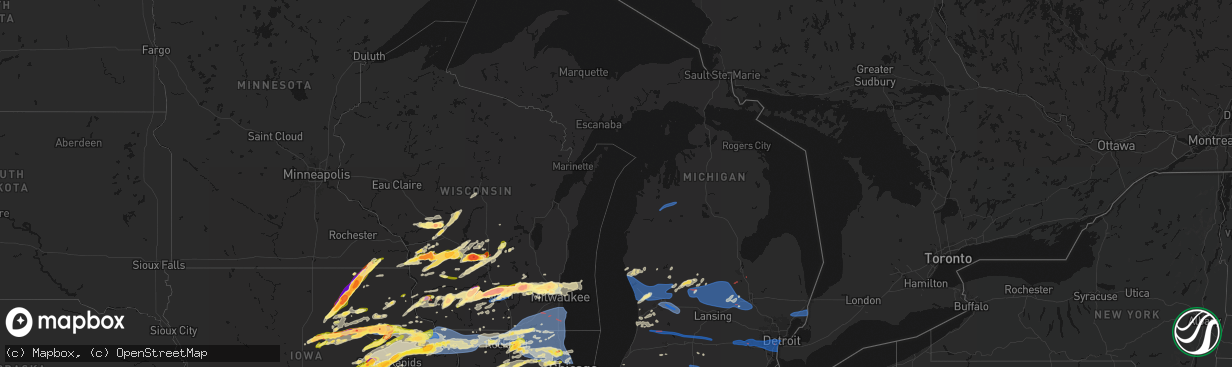
Hail Map in Michigan on April 14, 2026
The weather event in Michigan on April 14, 2026 includes Hail, Tornado, and Wind maps. 18 states and 1,229 cities were impacted and suffered possible damage. The total estimated number of properties impacted is 0.
Hail
Tornado
Wind
0
Estimated number of impacted properties by a 1.00" hail or larger0
Estimated number of impacted properties by a 1.75" hail or larger0
Estimated number of impacted properties by a 2.50" hail or largerStorm reports in Michigan
Michigan
| Date | Description |
|---|---|
| 04/14/20261:17 AM CDT | Damage to trees and power lines starting around the i-275 and i-75 interchange spreading east toward estral beach |
| 04/14/20261:14 AM CDT | Nws storm survey team confirms an ef-1 tornado occurred in lincoln park on april 15. A brief tornado touched down near wall ave and ruth ave... And continued across res |
| 04/14/20261:08 AM CDT | A local report indicates 69 MPH wind near Detroit Metro Intl Airp |
| 04/14/20261:08 AM CDT | Measured at willow run airport. |
| 04/14/20261:05 AM CDT | Power lines and poles down across middle belt rd south of van born in romulus. |
| 04/14/202612:49 AM CDT | Measured at the university of michigan stadium. |
| 04/14/202612:45 AM CDT | Trees and power lines reported down across parts of the county... Especially in the ann arbor and ypsilanti area. |
| 04/14/202612:44 AM CDT | Nws storm survey team confirms an ef-1 tornado occurred in ann arbor on april 15. The tornado started in the area of jackson ave near interstate 94... Continued southea |
| 04/14/202612:38 AM CDT | Tree down blocking southbound lane of parker road between trinkle road and i-94. Reports of debris in the area. |
| 04/14/202612:25 AM CDT | Numerous trees and powerlines down... Along with damage to a large shed. |
| 04/14/202612:20 AM CDT | Trained spotter reported trees and powerlines down near bibbins road and us-12 intersection due to thunderstorm winds in hillsdale county in michigan. |
| 04/13/202611:32 PM CDT | Six inch diameter tree limb down. |
| 04/13/202611:10 PM CDT | Many twisted and broken trees down on property. Barn roof removed. Neighbors greenhouse ended up in their yard. Time approximate. |
| 04/13/202611:09 PM CDT | Several limbs and trees down along with trees uprooted in western genesee along grand blanc rd to seymour rd. Tim estimated off radar. |
| 04/13/202611:06 PM CDT | Nws storm survey team confirms an ef-0 tornado occurred in bridgeport on april 15. The tornado started northwest of roedel rd and s reimer rd... Continued southeast bef |
| 04/13/202611:00 PM CDT | Trees uprooted. |
| 04/13/202611:00 PM CDT | Roof damage along with greenhouse damage. Trees down as well. Time and location approximate. |
| 04/13/202610:58 PM CDT | Nws storm survey team confirms an ef-0 tornado occurred in durand on april 14. The tornado started near newburg rd just west of lansing rd... Continued east before lift |
| 04/13/202610:53 PM CDT | Nws storm survey confirms an ef-1 tornado occurred in albee township on april 14. The tornado started just northwest of w birch run rd and amman rd... Continued northea |
| 04/13/202610:52 PM CDT | This ef-1 tornado had maximum estimated winds of 100 mph and a path of around 16 miles. It touched down north of otsego and traveled east until hickory corners. This to |
| 04/13/202610:49 PM CDT | A few pieces of siding from a house ripped off and downed trees. |
| 04/13/202610:49 PM CDT | Some shingles from a house ripped off and downed trees. |
| 04/13/202610:40 PM CDT | Trees reported down near grand river road and delaney road. |
| 04/13/202610:38 PM CDT | An ef-0 tornado with peak winds near 80 mph began near schermerhorn lake in allegan county and was on the ground for around 6.5 miles before lifting west/northwest of o |
| 04/13/202610:11 PM CDT | A local report indicates 60 MPH wind near 1 W East Grand Rapids |
| 04/13/202610:00 PM CDT | Tree on house in the alto area. Time and location approximate. |
| 04/13/20269:58 PM CDT | A surge of thunderstorm winds occurred from the grand rapids airport southeast through the whitneyville area... Where a large tree fell on a house... Doing extensive da |
| 04/13/20269:57 PM CDT | Asos station kgrr gerald r ford intl. |
| 04/13/20269:51 PM CDT | An ef1 tornado with top winds near 110 mph began 2 miles east of fenwick in montcalm county... Moving east-northeast almost 19 miles before ending just east of perrinto |
| 04/13/20269:50 PM CDT | Gust at the gerald r ford international airport. |
| 04/13/20269:50 PM CDT | Delayed report. Lots of 10-12 inch trees down... Generally in one direction. Damage seems to be condensed to a small area between given location and county line rd. Tim |
| 04/13/20269:31 PM CDT | A local report indicates 61 MPH wind near 1 SW Comstock Park |
All States Impacted by Hail Map on April 14, 2026
Cities Impacted by Hail Map on April 14, 2026
- Mannsville, NY
- Sandy Creek, NY
- Lacona, NY
- Adams, NY
- Lorraine, NY
- Taberg, NY
- West Leyden, NY
- Radcliffe, IA
- Ellsworth, IA
- Hubbard, IA
- Eldora, IA
- Iowa Falls, IA
- Seymour, TX
- Munday, TX
- Steamboat Rock, IA
- Wellsburg, IA
- Grundy Center, IA
- Parkersburg, IA
- Monticello, IN
- Ramey, PA
- Clinton, IN
- Houtzdale, PA
- Dana, IN
- Holland, IA
- Dike, IA
- Idaville, IN
- Burnettsville, IN
- Montezuma, IN
- Bloomingdale, IN
- Hillsdale, IN
- Electra, TX
- Monon, IN
- Rensselaer, IN
- Crawfordsville, IN
- Darlington, IN
- Ladoga, IN
- New Ross, IN
- Ackley, IA
- Geneva, IA
- Bristow, IA
- Dumont, IA
- Allison, IA
- Reinbeck, IA
- Cedar Falls, IA
- Greene, IA
- Delphi, IN
- Oelwein, IA
- Logansport, IN
- Royal Center, IN
- Shell Rock, IA
- Maynard, IA
- Fayette, IA
- Wadena, IA
- New Hartford, IA
- Jamestown, IN
- Elgin, IA
- Dodgeville, WI
- Advance, IN
- Lebanon, IN
- Waterloo, IA
- Clarksville, IA
- Lucerne, IN
- Twelve Mile, IN
- Iowa Park, TX
- Plainfield, IA
- Kewanna, IN
- Rochester, IN
- Flora, IN
- Bringhurst, IN
- Ridgeway, WI
- Mineral Point, WI
- Janesville, IA
- Camden, IN
- Bowerston, OH
- Caledonia, MN
- Galveston, IN
- Walton, IN
- Westgate, IA
- Comstock, TX
- Young America, IN
- Kokomo, IN
- Barneveld, WI
- Charles City, IA
- Nashua, IA
- Blue Mounds, WI
- Stoddard, WI
- Chaseburg, WI
- Genoa, WI
- Viroqua, WI
- Queensbury, NY
- Glens Falls, NY
- Lake George, NY
- Salem, NY
- Fort Edward, NY
- Argyle, NY
- Granville, NY
- Lake Luzerne, NY
- Hartford, NY
- Fort Ann, NY
- Hudson Falls, NY
- Evansdale, IA
- Whitestown, IN
- Waverly, IA
- Black Earth, WI
- Burkburnett, TX
- Dewar, IA
- Dorset, VT
- West Rupert, VT
- Grandfield, OK
- Mount Horeb, WI
- Harrold, TX
- Mentone, IN
- Jewett, OH
- Cadiz, OH
- Scio, OH
- Paducah, TX
- Carrollton, OH
- Tippecanoe, IN
- Readlyn, IA
- Denver, IA
- Raymond, IA
- Bunker Hill, IN
- Brownsville, MN
- Arena, WI
- Mazomanie, WI
- Dunkerton, IA
- Warsaw, IN
- Etna Green, IN
- Ionia, IA
- Westby, WI
- Coon Valley, WI
- Independence, IA
- Jesup, IA
- Manchester Center, VT
- Arlington, VT
- New Hampton, IA
- Alta Vista, IA
- Middleton, WI
- Madison, WI
- Verona, WI
- Del Rio, TX
- Girard, TX
- Spur, TX
- West Union, IA
- Conrad, IA
- Cross Plains, WI
- Hopedale, OH
- Oran, IA
- Fairbank, IA
- Cashton, WI
- Devol, OK
- Clermont, IA
- Norwalk, WI
- Claypool, IN
- Peru, IN
- Akron, IN
- Onward, IN
- Greentown, IN
- Hazleton, IA
- Amboy, IN
- Elma, IA
- Converse, IN
- Sumner, IA
- Tripoli, IA
- Waunakee, WI
- Ottumwa, IA
- Blakesburg, IA
- Randlett, OK
- Edgewood, IA
- Elkport, IA
- Garrison, IA
- Silver Lake, IN
- Crowell, TX
- New Providence, IA
- Zearing, IA
- Chelsea, IA
- Swayzee, IN
- Marion, IN
- Hudson, IA
- Jayton, TX
- Cottage Grove, WI
- Deerfield, WI
- Marshall, WI
- Waterloo, WI
- Mcfarland, WI
- Stoughton, WI
- Oregon, WI
- Wabash, IN
- Bangor, WI
- Rockland, WI
- La Farge, WI
- Cambridge, WI
- Keystone, IA
- Marengo, IA
- Gilbertville, IA
- La Porte City, IA
- Sparta, WI
- Brooklyn, IA
- Hartwick, IA
- Sweetser, IN
- Monona, IA
- Burket, IN
- Childress, TX
- Bagley, WI
- Bloomington, WI
- Prairie Du Chien, WI
- Snyder, TX
- Aspermont, TX
- Union, IA
- Brandon, IA
- Vinton, IA
- Mount Auburn, IA
- Ontario, WI
- Hedrick, IA
- Rowley, IA
- Urbana, IA
- Walker, IA
- Center Point, IA
- Aurora, IA
- Winthrop, IA
- Sun Prairie, WI
- Deforest, WI
- Lodi, WI
- Garnavillo, IA
- Garber, IA
- Guttenberg, IA
- Belle Plaine, IA
- Elberon, IA
- Vining, IA
- Blairstown, IA
- Rayland, OH
- Mingo Junction, OH
- Mount Hope, WI
- Hillsboro, WI
- Amsterdam, OH
- Woodman, WI
- La Fontaine, IN
- Watertown, WI
- Van Horne, IA
- Sayre, OK
- Stanley, IA
- Arlington, IA
- Van Buren, IN
- Lake Mills, WI
- Johnson Creek, WI
- Patch Grove, WI
- Unionville, IA
- Moravia, IA
- Cresco, IA
- Lime Springs, IA
- Gas City, IN
- Masonville, IA
- Lamont, IA
- Quasqueton, IA
- Reeseville, WI
- Tomah, WI
- Agency, IA
- Batavia, IA
- Elk City, OK
- Ollie, IA
- Martinsburg, IA
- Luzerne, IA
- Kendall, WI
- Glen Haven, WI
- Platteville, WI
- Livingston, WI
- Temple, OK
- Walters, OK
- Melrose, WI
- Ettrick, WI
- Black River Falls, WI
- Seymour, IA
- Centerville, IA
- Jefferson, WI
- Newhall, IA
- Shellsburg, IA
- Atkins, IA
- Dundee, IA
- Manchester, IA
- Eitzen, MN
- Amana, IA
- Norway, IA
- Fairfax, IA
- Walford, IA
- Elroy, WI
- Pendleton, IN
- Wonewoc, WI
- Watkins, IA
- Sigourney, IA
- Hayesville, IA
- Harper, IA
- Keota, IA
- South English, IA
- Wellman, IA
- Canton, MN
- Harmony, MN
- Packwood, IA
- Fairfield, IA
- Hartford City, IN
- Mauston, WI
- Springville, IA
- Cedar Rapids, IA
- Anamosa, IA
- Marion, IA
- Mount Vernon, IA
- Vernon, TX
- Montpelier, IN
- Earlville, IA
- Coggon, IA
- Delaware, IA
- Delhi, IA
- Ryan, IA
- Kalona, IA
- Parnell, IA
- Central City, IA
- Fennimore, WI
- Iowa City, IA
- Boscobel, WI
- Richland, IA
- Brighton, IA
- Harpers Ferry, IA
- Lyndon Station, WI
- Wisconsin Dells, WI
- La Valle, WI
- Reedsburg, WI
- Helenville, WI
- Wilton, WI
- Butler, OK
- Ixonia, WI
- Comanche, OK
- Duncan, OK
- Upland, IN
- Monaca, PA
- Aliquippa, PA
- Industry, PA
- Shippingport, PA
- Warren, IN
- Warrens, WI
- Canute, OK
- Portland, IN
- Bryant, IN
- Dalton, WI
- Montello, WI
- Portage, WI
- Pardeeville, WI
- Gould, OK
- Dillonvale, OH
- Pennville, IN
- Cobb, WI
- Highland, WI
- Montfort, WI
- Muscoda, WI
- Bloomingdale, OH
- Adena, OH
- Sewickley, PA
- Ambridge, PA
- Leetsdale, PA
- Rewey, WI
- Linden, WI
- Palo, IA
- Toddville, IA
- Vinson, OK
- Dysart, IA
- Gladbrook, IA
- Beaman, IA
- Whitten, IA
- Morrison, IA
- Hopkinton, IA
- Quanah, TX
- Keystone, IN
- Dunkirk, IN
- Geneva, IN
- Lancaster, WI
- Georgetown, PA
- Midland, PA
- Mabel, MN
- Clinton, OK
- Carter, OK
- Willow, OK
- Decatur, IN
- McGregor, IA
- Jonesboro, IN
- Huntington, IN
- Aplington, IA
- Ely, IA
- Martelle, IA
- Oxford, IA
- Coralville, IA
- Center Junction, IA
- Monticello, IA
- Lebanon, WI
- Solon, IA
- Oconomowoc, WI
- Ashippun, WI
- Lanesboro, MN
- Colesburg, IA
- Fort Recovery, OH
- Duke, OK
- Preston, MN
- Markesan, WI
- Avoca, WI
- Spring Green, WI
- Babcock, WI
- Pittsville, WI
- Neosho, WI
- Hartland, WI
- Sullivan, WI
- Hartford, WI
- Foss, OK
- Old Glory, TX
- Rubicon, WI
- Dyersville, IA
- Worthington, IA
- Mendon, OH
- Rockford, OH
- Robins, IA
- Alburnett, IA
- Hiawatha, IA
- Bluffton, IN
- Markle, IN
- Coldwater, OH
- Rushford, MN
- Peterson, MN
- Okauchee, WI
- Nashotah, WI
- Colgate, WI
- Washington, IA
- Wayland, IA
- Mount Pleasant, IA
- West Branch, IA
- Sussex, WI
- Tipton, IA
- Mechanicsville, IA
- Olustee, OK
- Mangum, OK
- Blair, OK
- Altus, OK
- Saint Henry, OH
- Grand Marsh, WI
- Oxford, WI
- Wapakoneta, OH
- Saint Marys, OH
- Briggsville, WI
- Stitzer, WI
- Princeton, WI
- Cascade, IA
- Farley, IA
- Westfield, WI
- Wisconsin Rapids, WI
- Onslow, IA
- Marlow, OK
- Endeavor, WI
- Arapaho, OK
- Celina, OH
- Salamonia, IN
- Spencerville, OH
- Epworth, IA
- Hordville, NE
- Polk, NE
- Adams, WI
- Delafield, WI
- Hubertus, WI
- Menomonee Falls, WI
- Pewaukee, WI
- Brookfield, WI
- Lannon, WI
- Peosta, IA
- Bernard, IA
- Dubuque, IA
- Crawfordsville, IA
- Columbus Junction, IA
- Winfield, IA
- Butler, WI
- Germantown, WI
- Venedocia, OH
- Delphos, OH
- Lima, OH
- Milwaukee, WI
- Maquoketa, IA
- Monmouth, IA
- Baldwin, IA
- Harrod, OH
- Wyoming, IA
- New Bremen, OH
- Montezuma, OH
- Minster, OH
- Maria Stein, OH
- Chickasaw, OH
- New Knoxville, OH
- Anna, OH
- Zionsville, IN
- Houston, MN
- Mount Blanchard, OH
- Bucyrus, OH
- Neshkoro, WI
- Richfield, WI
- Mequon, WI
- Davidson, OK
- La Motte, IA
- Zwingle, IA
- Bellevue, IA
- Leesburg, IN
- North Webster, IN
- Lone Wolf, OK
- Hobart, OK
- Roosevelt, OK
- Columbus City, IA
- Letts, IA
- Wapello, IA
- Hazel Green, WI
- East Dubuque, IL
- Andrew, IA
- Plymouth, OH
- Shelby, OH
- Tiro, OH
- Juneau, WI
- Bloomville, OH
- New Washington, OH
- Botkins, OH
- Oklaunion, TX
- Shiloh, OH
- Ripon, WI
- Green Lake, WI
- Stanton, TX
- Belleville, WI
- Wales, WI
- Waukesha, WI
- Junction City, WI
- Shelby, NE
- Galena, IL
- Milladore, WI
- Attica, OH
- Grandview, IA
- Miles, IA
- Hanover, IL
- Sabula, IA
- Savanna, IL
- Spragueville, IA
- Elizabeth, IL
- Stockton, IL
- Scales Mound, IL
- Apple River, IL
- Cuba City, WI
- Shullsburg, WI
- Willard, OH
- Frederick, OK
- New Glarus, WI
- Blanchardville, WI
- Hollandale, WI
- Brooklyn, WI
- Lawton, OK
- Monticello, WI
- Muscatine, IA
- New Boston, IL
- Hollister, OK
- Whitehall, MI
- Chatfield, OH
- Tipton, OK
- Preston, IA
- McConnell, IL
- Shannon, IL
- Kent, IL
- Lena, IL
- Pearl City, IL
- Mount Carroll, IL
- Lanark, IL
- Freeport, IL
- Holton, MI
- Twin Lake, MI
- Evansville, WI
- Fort Sill, OK
- Montague, MI
- Loveland, OK
- Albany, WI
- Chattanooga, OK
- Indiahoma, OK
- Cache, OK
- Cedarville, IL
- Dakota, IL
- Rothbury, MI
- Edgerton, WI
- Gail, TX
- Holy Cross, IA
- Elgin, OK
- Rocksprings, TX
- Faxon, OK
- Geronimo, OK
- Midland, TX
- Fremont, MI
- Ridott, IL
- Pecatonica, IL
- Davis, IL
- Rock City, IL
- Fletcher, OK
- Rush Springs, OK
- Newaygo, MI
- Wauzeka, WI
- East Troy, WI
- Burlington, WI
- Waterford, WI
- Genoa City, WI
- Twin Lakes, WI
- Franksville, WI
- Union Grove, WI
- Rochester, WI
- Kansasville, WI
- Readstown, WI
- Rockton, IL
- Rockford, IL
- Winnebago, IL
- White Cloud, MI
- Belding, MI
- Greenville, MI
- Rockford, MI
- Cedar Springs, MI
- Howard City, MI
- Morley, MI
- Salem, WI
- Caledonia, WI
- Oak Creek, WI
- Muskego, WI
- Richmond, IL
- Franklin, WI
- Spring Grove, IL
- Silver Lake, WI
- Wilmot, WI
- Antioch, IL
- Bristol, WI
- Trevor, WI
- Sturtevant, WI
- Racine, WI
- Fox Lake, IL
- Ninnekah, OK
- Muskegon, MI
- Capron, IL
- Poplar Grove, IL
- Roscoe, IL
- Sharon, WI
- Springfield, WI
- Caledonia, IL
- Clinton, WI
- Beloit, WI
- Darien, WI
- Garden Prairie, IL
- Williams Bay, WI
- Durand, IL
- South Beloit, IL
- Delavan, WI
- Fontana, WI
- Elkhorn, WI
- Belvidere, IL
- Machesney Park, IL
- Loves Park, IL
- Woodstock, IL
- Walworth, WI
- Cherry Valley, IL
- Hebron, IL
- Lake Geneva, WI
- Marengo, IL
- Harvard, IL
- Monroe Center, IL
- Pratt, KS
- Sawyer, KS
- Sidney, MI
- Sheridan, MI
- Viola, WI
- German Valley, IL
- Baileyville, IL
- Pierson, MI
- Nickerson, KS
- Hutchinson, KS
- New Vienna, IA
- West Olive, MI
- Grand Haven, MI
- Gowen, MI
- Davis Junction, IL
- Wonder Lake, IL
- Turon, KS
- Spring Lake, MI
- Stafford, KS
- Fruitport, MI
- Nunica, MI
- Coopersville, MI
- Ravenna, MI
- Kenosha, WI
- Bradley, OK
- Lindsay, OK
- Prague, OK
- Paden, OK
- Kent City, MI
- Casnovia, MI
- Conklin, MI
- Sylvia, KS
- Mchenry, IL
- Crystal Lake, IL
- Ingleside, IL
- Fox River Grove, IL
- Wauconda, IL
- Grayslake, IL
- Cary, IL
- Ringwood, IL
- Island Lake, IL
- Huntley, IL
- Barrington, IL
- Round Lake, IL
- Lake Villa, IL
- Lake In The Hills, IL
- Union, IL
- Sparta, MI
- Leakey, TX
- Allendale, MI
- Pleasant Prairie, WI
- Lake Zurich, IL
- Gurnee, IL
- Mundelein, IL
- Zion, IL
- Wadsworth, IL
- Libertyville, IL
- Stanton, MI
- Vestaburg, MI
- Riverdale, MI
- Richland Center, WI
- Kirkland, IL
- Ashton, IL
- Franklin Grove, IL
- Edmore, MI
- Riceville, IA
- Grand Rapids, MI
- Marne, MI
- Plevna, KS
- Sycamore, IL
- Kingston, IL
- Genoa, IL
- Hampshire, IL
- Burlington, IL
- Gilberts, IL
- Algonquin, IL
- Dundee, IL
- Carpentersville, IL
- Abbyville, KS
- Rochelle, IL
- Crystal, MI
- Comstock Park, MI
- Belmont, MI
- Sand Lake, MI
- Elgin, IL
- Waukegan, IL
- Winthrop Harbor, IL
- North Chicago, IL
- Vernon Hills, IL
- Ada, MI
- Sterling, KS
- Sumner, MI
- Malta, IL
- Lee, IL
- Carson City, MI
- Compton, IL
- Steward, IL
- Ridgeway, IA
- Clare, IL
- Cunningham, KS
- Dekalb, IL
- Tulsa, OK
- Palatine, IL
- Arlington Heights, IL
- Fenwick, MI
- Buffalo Grove, IL
- Hubbardston, MI
- Decorah, IA
- Diller, NE
- Alma, MI
- Lawler, IA
- Hubbell, NE
- Fairbury, NE
- Reynolds, NE
- Ithaca, MI
- Middleton, MI
- New Lisbon, WI
- Friendship, WI
- Mountain Home, TX
- Hoffman Estates, IL
- Esmond, IL
- Cook, NE
- Sterling, NE
- Farmersburg, IA
- Shabbona, IL
- Chana, IL
- Wyoming, MI
- Grandville, MI
- Streamwood, IL
- Bartlett, IL
- Lake Bluff, IL
- South Elgin, IL
- Great Lakes, IL
- Schaumburg, IL
- Lake Forest, IL
- Lincolnshire, IL
- Hanover Park, IL
- Rolling Meadows, IL
- Elk Grove Village, IL
- Medinah, IL
- Roselle, IL
- Bloomingdale, IL
- Glendale Heights, IL
- Addison, IL
- Itasca, IL
- Prospect Heights, IL
- Wheeling, IL
- Deerfield, IL
- Caledonia, MI
- Beatrice, NE
- Maple Park, IL
- Saint Charles, IL
- Cortland, IL
- Stuart, IA
- Dexter, IA
- Northbrook, IL
- Mount Prospect, IL
- Junction, TX
- Crab Orchard, NE
- Filley, NE
- Tecumseh, NE
- Talmage, NE
- Nebraska City, NE
- Muir, MI
- Winslow, IL
- Alto, MI
- Lowell, MI
- Freeport, MI
- Clarksville, MI
- Wetumka, OK
- Waucoma, IA
- Calmar, IA
- Highland Park, IL
- Glencoe, IL
- Lake Odessa, MI
- Broken Arrow, OK
- Coweta, OK
- Bixby, OK
- Mounds, OK
- Glenpool, OK
- Jenks, OK
- Sapulpa, OK
- Kiefer, OK
- Inola, OK
- Catoosa, OK
- Claremore, OK
- Okemah, OK
- Weleetka, OK
- Concordia, KS
- Scandia, KS
- Wayne, IL
- West Chicago, IL
- Dunbar, NE
- Lorton, NE
- Orangeville, IL
- Monroe, WI
- Winnetka, IL
- Blue River, WI
- Glen Elder, KS
- Zeeland, MI
- Bensenville, IL
- Wood Dale, IL
- Cawker City, KS
- Baden, PA
- Ionia, MI
- Orleans, MI
- Fowler, MI
- Pewamo, MI
- Westphalia, MI
- Lyons, MI
- Des Plaines, IL
- Perrinton, MI
- Ashley, MI
- Saint Johns, MI
- Maple Rapids, MI
- Pompeii, MI
- North Star, MI
- Wheeler, MI
- Saint Charles, MI
- Ovid, MI
- Elsie, MI
- Brant, MI
- Bannister, MI
- Courtland, KS
- Carol Stream, IL
- Fennville, MI
- Narka, KS
- Belleville, KS
- Munden, KS
- Norway, KS
- Glenview, IL
- Jansen, NE
- Lynnville, IA
- Hamilton, MI
- Hudsonville, MI
- Dorr, MI
- Holland, MI
- Byron Center, MI
- Mankato, KS
- Owosso, MI
- Corunna, MI
- Percival, IA
- Harwood Heights, IL
- Schiller Park, IL
- Lincolnwood, IL
- Niles, IL
- Skokie, IL
- Chicago, IL
- Park Ridge, IL
- Beloit, KS
- Randall, KS
- Allegan, MI
- Durand, MI
- Douglas, MI
- Saugatuck, MI
- Grinnell, IA
- Newton, IA
- Byars, OK
- Wanette, OK
- Dewitt, MI
- Oakley, MI
- Perry, MI
- Henderson, MI
- Laingsburg, MI
- Adams, NE
- Morrice, MI
- Chesaning, MI
- Bancroft, MI
- Hamburg, IA
- Sidney, IA
- Otsego, MI
- Riverton, IA
- Plainwell, MI
- Big Spring, TX
- New Lothrop, MI
- Lennon, MI
- Vernon, MI
- Golf, IL
- Morton Grove, IL
- Wilmette, IL
- Highwood, IL
- Farragut, IA
- Swartz Creek, MI
- Gaines, MI
- Byron, MI
- Ferryville, WI
- Soldiers Grove, WI
- Wild Rose, WI
- Jewell, KS
- Essex, IA
- Imogene, IA
- Endicott, NE
- Cuba, KS
- Formoso, KS
- Mahaska, KS
- Haddam, KS
- Rock Springs, WI
- North Freedom, WI
- Loganville, WI
- Winfield, IL
- Evanston, IL
- Kellogg, IA
- Brock, NE
- Victor, IA
- Plain, WI
- Hillpoint, WI
- Hopkins, MI
- Virginia, NE
- Peru, NE
- Malcom, IA
- Morrowville, KS
- Juda, WI
- Prescott, IA
- Baraboo, WI
- Janesville, WI
- Shenandoah, IA
- Fremont, WI
- Rock Port, MO
- Red Oak, IA
- Weyauwega, WI
- Waupaca, WI
- Clarinda, IA
- Villisca, IA
- Kenilworth, IL
- Cazenovia, WI
- Lime Ridge, WI
- Hollenberg, KS
- Sully, IA
- Vicksburg, MI
- Creston, IA
- Steele City, NE
- Coin, IA
- Schoolcraft, MI
- Prairieburg, IA
- Langworthy, IA
- Stanton, IA
- Wewoka, OK
- Maud, OK
- Seminole, OK
- Brodhead, WI
- Holly, MI
- Fenton, MI
- Flint, MI
- Linden, MI
- Grand Blanc, MI
- Orient, IA
- Nodaway, IA
- Homer, MI
- Tekonsha, MI
- Pickrell, NE
- Blue Springs, NE
- Wymore, NE
- Odell, NE
- Corning, IA
- Carbon, IA
- Burchard, NE
- Winterset, IA
- Ladora, IA
- Liberty, NE
- Steinauer, NE
- Holdenville, OK
- Laughlin Afb, TX
- Brackettville, TX
- Elk Creek, NE
- Prole, IA
- Lewiston, NE
- Greenfield, IA
- Swisher, IA
- Patterson, IA
- Henryetta, OK
- Okmulgee, OK
- Lisbon, IA
- Windsor, WI
- Cyril, OK
- Cement, OK
- Saint Charles, IA
- North Liberty, IA
- Tiffin, IA
- Muskogee, OK
- Webbers Falls, OK
- Warner, OK
- Gore, OK
- Vian, OK
- Stilwell, OK
- Tahlequah, OK
- Welling, OK
- Lorimor, IA
- Chickasha, OK
- Proctor, OK
- Westville, OK
- Lincoln, AR
- Summers, AR
- Canehill, AR
- Fayetteville, AR
- Prairie Grove, AR
- Farmington, AR
- Springdale, AR
- Hindsville, AR
- Huntsville, AR
- Elkins, AR
- Rogers, AR
- Eureka Springs, AR
- Berryville, AR
- North English, IA
- New Virginia, IA
- Indianola, IA
- Ann Arbor, MI
- Dexter, MI
- Chelsea, MI
- Grass Lake, MI
- Ypsilanti, MI
- Whitmore Lake, MI
- Plymouth, MI
- Canton, MI
- Belleville, MI
- Inkster, MI
- Romulus, MI
- Dearborn Heights, MI
- Wayne, MI
- Dearborn, MI
- Westland, MI
- Garden City, MI
- Noble, OK
- Lexington, OK
- Williamsburg, IA
- Milo, IA
- Baroda, MI
- Bridgman, MI
- Riverside, IA
- Taylor, MI
- Detroit, MI
- Trenton, MI
- Lincoln Park, MI
- Southgate, MI
- Allen Park, MI
- Wyandotte, MI
- Grosse Ile, MI
- Riverview, MI
- River Rouge, MI
- Melvindale, MI
- Ecorse, MI
- Forreston, IL
- Leaf River, IL
- Hills, IA
- Delta, IA
- Eddyville, IA
- Cedar, IA
- Fremont, IA
- Kirkville, IA
- Lindenwood, IL
- Castle, OK
- Bristow, OK
- Boley, OK
- Greeley, IA
- Beggs, OK
- Olds, IA
- Lenox, IA
- D Hanis, TX
- Hondo, TX
- Mesick, MI
- Afton, IA
- Kingsley, MI
- Buckley, MI
- Manton, MI
- Fife Lake, MI
- Johnstown, OH
- Alexandria, OH
- Pataskala, OH
- Granville, OH
- McClelland, IA
- Minden, IA
- Pickett, WI
- Omro, WI
- Jackson, WI
- Cedarburg, WI
- West Bend, WI
- Cassville, WI
- Potosi, WI
- Waterville, IA
- Postville, IA
- Luana, IA
- Waukon, IA
- Marquette, IA
- Cambria, WI
- Poynette, WI
- Packwaukee, WI
- Saint Olaf, IA
- Sherrill, IA
- Rushsylvania, OH
- Bellefontaine, OH
- Zanesfield, OH
- West Mansfield, OH
- Dublin, NH
- Marlborough, NH
- Harrisville, NH
- Keene, NH
- Coeymans Hollow, NY
- Clarksville, NY
- Selkirk, NY
- Ravena, NY
- Voorheesville, NY
- Westerlo, NY
- Feura Bush, NY
- Delmar, NY
- Alcove, NY
- South Bethlehem, NY
- Castleton On Hudson, NY
- Schodack Landing, NY
- Glenmont, NY
- Nassau, NY
- Pittsfield, MA
- Colwell, IA
- Coldwater, MI
- Quincy, MI
- Marble Rock, IA
- Hillsdale, MI
- Reading, MI
- Oktaha, OK
- Fort Gibson, OK
- Bella Vista, AR
- Cave Springs, AR
- Gravette, AR
- Noel, MO
- Jay, OK
- Gentry, AR
- Hiwasse, AR
- Anderson, MO
- Garfield, AR
- Watts, OK
- Decatur, AR
- Centerton, AR
- Lowell, AR
- Bentonville, AR
- Powell, MO
- Maysville, AR
- Pineville, MO
- Colcord, OK
- Washburn, MO
- Sulphur Springs, AR
- Seligman, MO
- Siloam Springs, AR
- Pea Ridge, AR
- South West City, MO
- Olivet, MI
- Springport, MI
- Albion, MI
- Delton, MI
- Battle Creek, MI
- Hickory Corners, MI
- Marshall, MI
- Bellevue, MI
- Augusta, MI
- Parma, MI
- Dowling, MI
- East China, MI
- Marine City, MI
- New Haven, MI
- Casco, MI
- Saint Clair, MI
- Frankenmuth, MI
- Bridgeport, MI
- Rockwood, MI
- Carleton, MI
- Newport, MI
- South Rockwood, MI
- Monroe, MI
- Flat Rock, MI
- Park Hill, OK


