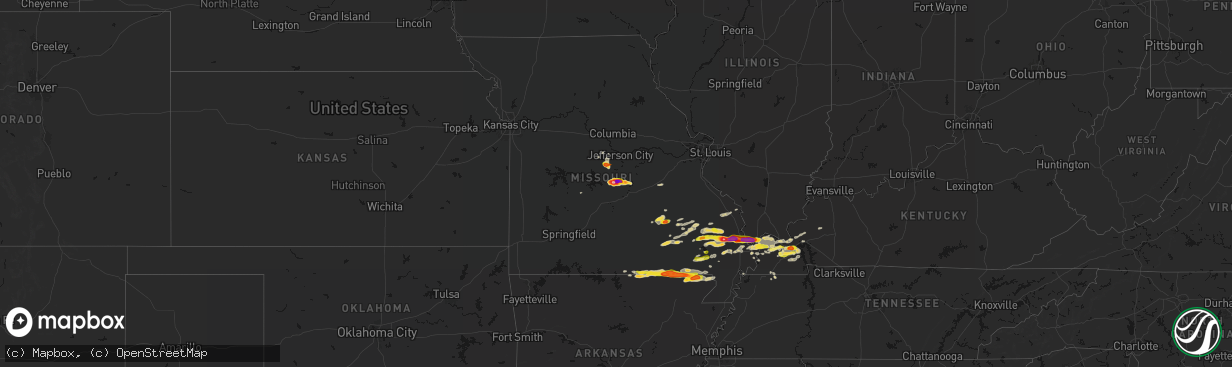
Hail Map on April 16, 2026
The weather event on April 16, 2026 includes Hail, Wind, and Tornado maps. 11 states and 357 cities were impacted and suffered possible damage. The total estimated number of properties impacted is 59,356.
Hail
Wind
Tornado
59,356
Estimated number of impacted properties by a 1.00" hail or larger18,697
Estimated number of impacted properties by a 1.75" hail or larger1,611
Estimated number of impacted properties by a 2.50" hail or largerStates Impacted by Hail Map on April 16, 2026
Storm reports
Missouri
| Date | Description |
|---|---|
| 04/16/20266:57 PM CDT | A local report indicates 1.00 inch wind near 3 E Naylor |
| 04/16/20265:44 PM CDT | Pictures of tennis ball size hail near eugene. |
| 04/16/20265:32 PM CDT | Corrects previous hail report from 2 n eugene. |
| 04/16/20265:26 PM CDT | A local report indicates 1.00 inch wind near 2 N Eugene |
| 04/16/20265:25 PM CDT | Delayed report... Time estimated from radar. Emergency management estimated hail between golf ball and tennis ball size... Though photo was representative of tennis bal |
| 04/16/20265:20 PM CDT | Multiple reports of golf ball size hail reported by the public... Relayed by regional skywarn ham operator. |
| 04/16/20265:18 PM CDT | Report from mping of quarter size hail. |
| 04/16/20265:05 PM CDT | A local report indicates 1.00 inch wind near 3 S Wappapello |
| 04/16/20265:04 PM CDT | A local report indicates 1.00 inch wind near Olean |
| 04/16/20264:41 PM CDT | A local report indicates 1.00 inch wind near 1 SE Poplar Bluff |
| 04/16/20264:29 PM CDT | A local report indicates 1.00 inch wind near 4 W Poplar Bluff |
| 04/16/20264:01 PM CDT | Hail from quarters to golf balls in size fell for more than 25 minutes. |
| 04/16/20263:58 PM CDT | Delayed report... Time estimated from radar. A lot of small hail with a few ping pong sized pieces. |
| 04/16/20263:24 PM CDT | A local report indicates 1.75 inch wind near 1 ESE Oran |
| 04/16/20263:09 PM CDT | A local report indicates 1.50 inch wind near 2 SSW New Hamburg |
| 04/16/20263:08 PM CDT | Multiple social media reports show hail in benton. |
| 04/16/20263:00 PM CDT | Lots of limbs down in area of leopold... Some larger branches. |
| 04/16/20262:48 PM CDT | Powerlines down. |
| 04/16/20262:45 PM CDT | Part of a barn roof torn off along highway pp south of hwy ff. |
| 04/16/20262:45 PM CDT | A local report indicates 1.00 inch wind near Myrtle |
| 04/16/20262:45 PM CDT | A local report indicates 3.00 inch wind near 2 ENE Iberia |
| 04/16/20262:44 PM CDT | Tree down across roadway. |
| 04/16/20262:41 PM CDT | A local report indicates 1.75 inch wind near Iberia |
| 04/16/20262:41 PM CDT | A local report indicates 2.00 inch wind near Advance |
| 04/16/20262:39 PM CDT | Image of hailstone. |
| 04/16/20262:33 PM CDT | A local report indicates 2.75 inch wind near Advance |
| 04/16/20262:30 PM CDT | Social media images and videos. |
| 04/16/20262:30 PM CDT | A local report indicates 2.00 inch wind near Iberia |
| 04/16/20262:27 PM CDT | A local report indicates 1.25 inch wind near Iberia |
| 04/16/20262:03 PM CDT | A local report indicates 1.25 inch wind near 3 WSW Zalma |
| 04/16/20261:52 PM CDT | Hail to quarters in size reported. |
| 04/15/20267:05 PM CDT | Corrects previous hail report from 2 n kennett. Delayed report of quarter size hail 2 miles north of kennett. |
Kentucky
| Date | Description |
|---|---|
| 04/16/20266:56 PM CDT | Roof ripped off a barn. Time estimated from radar. |
| 04/16/20266:47 PM CDT | Downed trees reported off newtown road. |
| 04/16/20266:45 PM CDT | Multiple trees and power lines down throughout southeast logan county. |
| 04/16/20266:30 PM CDT | Kentucky mesonet measured 59 mph gust. |
| 04/16/20266:20 PM CDT | Tree uprooted on silvey rd in hopkinsville ky. |
| 04/16/20266:08 PM CDT | Shingles blown off roof in hopkinsville. Winds on the bypass observed at 50-55 mph. Power poles knocked down in hopkinsville. |
| 04/16/20266:08 PM CDT | *** 1 inj *** a tree was blown down onto a house on the 800 block of e 12th st. |
| 04/16/20266:05 PM CDT | Roof blown off a garage. |
| 04/16/20265:45 PM CDT | Late report. Trees down in city of murray. |
| 04/16/20265:45 PM CDT | Late report. Tree down on sugar creek road. |
| 04/16/20265:45 PM CDT | Late report. Several trees reported down throughout trigg county. |
| 04/16/20265:37 PM CDT | Tree downed blocking the parking lot of hematite lake picnic area... With at least one vehicle trapped in the parking lot. |
| 04/16/20265:35 PM CDT | Tree down on grooms lane. |
| 04/16/20265:25 PM CDT | Late report. Tree down in almo. |
| 04/16/20265:25 PM CDT | Tree down on friendship road. |
| 04/16/20265:24 PM CDT | Downed tree at ky-303 and martin rd. |
| 04/16/20265:17 PM CDT | Trees down... Spotter estimated 60 mph wind. |
| 04/16/20265:13 PM CDT | A local report indicates 1.00 inch wind near 1 ENE Benton |
| 04/16/20265:10 PM CDT | A local report indicates 1.00 inch wind near 6 S Calvert City |
| 04/16/20265:05 PM CDT | Trees down on briensburg tatumsville road northeast of benton. |
| 04/16/20265:03 PM CDT | Late report. Tree down blocking road in grand rivers area. |
| 04/16/20265:03 PM CDT | Late report. Some stones were egg size in palma community. |
| 04/16/20265:02 PM CDT | Trees and power lines down in mayfield. |
| 04/16/20264:56 PM CDT | A local report indicates 1.00 inch wind near 5 SSW Calvert City |
| 04/16/20264:56 PM CDT | Tree in the roadway blocking part of ky-849. |
| 04/16/20264:55 PM CDT | Damage to siding and broken windows in sharpe. |
| 04/16/20264:53 PM CDT | A local report indicates 1.00 inch wind near Hickory |
| 04/16/20264:51 PM CDT | Powerlines down. |
| 04/16/20264:51 PM CDT | Very large tree downed... Completely blocking the road at ky-534 and carman rd. |
| 04/16/20264:50 PM CDT | A local report indicates 1.50 inch wind near 5 SE Reidland |
| 04/16/20264:46 PM CDT | A local report indicates 1.00 inch wind near 2 S Folsomdale |
| 04/16/20264:46 PM CDT | Tree down blocking part of the road. |
| 04/16/20264:43 PM CDT | A large tree was downed partially blocking the road at herman and sturgill. A second tree on sturgill rd was fully blocking the road. |
| 04/16/20264:31 PM CDT | Trees down. |
| 04/16/20264:31 PM CDT | Downed power lines blocked ky-339 between ky-121 and ky-1213. |
| 04/16/20264:26 PM CDT | Trees and powerlines down. |
| 04/16/20264:16 PM CDT | Hail dented the back porch wood. |
| 04/16/20264:11 PM CDT | A local report indicates 1.00 inch wind near Wickliffe |
| 04/16/20264:01 PM CDT | Powerlines down. |
| 04/16/20263:56 PM CDT | A local report indicates 1.00 inch wind near 3 WSW Melber |
| 04/15/20267:30 PM CDT | Tree down on power line on gayle way. |
| 04/15/20267:25 PM CDT | Large tree down over the 3000 block of sportsman lake road. |
| 04/15/20267:19 PM CDT | Tree down at the intersection of rapids road and grace road. Tree is blocking all lanes of traffic. |
| 04/15/20267:13 PM CDT | Very large tree down over the 900 block of rapids road. The tree is blocking all lanes of traffic. |
Tennessee
| Date | Description |
|---|---|
| 04/16/20266:45 PM CDT | Power outages in cumberland furnace. Time estimated with radar. |
| 04/16/20266:45 PM CDT | Reports of tree damage relayed via social media. |
| 04/16/20266:45 PM CDT | Reports in adams and cedar hill of numerous trees down... As well as several brush fires in the same area. |
| 04/16/20266:34 PM CDT | Trees down... With one on power line and on fire. Time estimated from radar. |
| 04/16/20266:16 PM CDT | Trees down on hwy 232 near leatherwood road reported by ema. |
| 04/16/20266:12 PM CDT | Several trees and power lines down across benton county. |
| 04/16/20266:11 PM CDT | Report of a tree down on mansfield road at vale road. |
| 04/16/20266:02 PM CDT | Trees and power lines down on donelson parkway at the tn river bridge. Reported by ema. |
| 04/16/20266:01 PM CDT | Tree down over the intersection of west and east antioch road. |
| 04/16/20265:58 PM CDT | Tree down across log cabin road and buchanan road at cay lawrence road. |
| 04/16/20265:43 PM CDT | Tree down on henry midway road. |
| 04/16/20265:26 PM CDT | Report of a tree on a home on ralston road in martin. |
| 04/16/20265:08 PM CDT | Several trees down in the south fulton area. |
| 04/15/20269:20 PM CDT | Tree across webb ridge road & forrest drive... And tangled in power lines. |
| 04/15/20269:19 PM CDT | Reports of trees down on ashley drive in tullahoma. Relayed via #tspotter. |
| 04/15/20268:33 PM CDT | Wind damage to the roof of the library in manchester... Tn. Relayed via #tspotter. |
| 04/15/20268:00 PM CDT | Tree down on a house in chapel hill. Time estimated. Relayed via #tspotter. |
| 04/15/20268:00 PM CDT | About 3000 people without power in wilson county according to ema. |
| 04/15/20267:54 PM CDT | Report of large tree down on north side of armstrong valley road in south murfreesboro. |
| 04/15/20267:50 PM CDT | Fence down in rockvale due to the winds... Relayed via broadcast media. |
| 04/15/20267:49 PM CDT | Tree down on the 7100 block of trousdale ferry pike. |
| 04/15/20267:49 PM CDT | Reports of utility poles down in between hartmann drive and hunters village drive. Time estimated. |
| 04/15/20267:45 PM CDT | Multiple reports of power outages in dickson county. Relayed by amateur radio. |
| 04/15/20267:37 PM CDT | Tree down in antioch on anderson road. Time estimated from radar. |
| 04/15/20267:36 PM CDT | Tree down and on a car. Time estimated from radar. Relayed via facebook. |
| 04/15/20267:36 PM CDT | Asos station peak gust kbna nashville intl airport. |
| 04/15/20267:36 PM CDT | Corrects previous tstm wnd gst report from 4 n antioch. Asos station peak gust kbna nashville intl airport. |
| 04/15/20267:31 PM CDT | No working red lights and down trees on central pike in hermitage. Time estimated. |
| 04/15/20267:29 PM CDT | Power outages in hendersonville. |
| 04/15/20267:27 PM CDT | Several trees down across robertson county... Including in springfield... Orlinda... And greenbrier. Power lines down as well. |
| 04/15/20267:25 PM CDT | Trees down on live power line... Relayed via #tspotter. |
| 04/15/20267:25 PM CDT | Multiple reports of trees down in franklin. |
| 04/15/20267:19 PM CDT | Trees blocking sanders ferry road in hendersonville. |
| 04/15/20267:19 PM CDT | Huge tree down blocking shoulder and parts of the westbound lane on i-40. Relayed by nash severe wx. |
| 04/15/20267:10 PM CDT | Trees across both lanes of crocker springs road. Time estimated via radar. |
| 04/15/20267:06 PM CDT | Roof damage to a convenience store from strong winds. Time estimated from radar. |
| 04/15/20267:01 PM CDT | Reports of power outages in hickman county... With trees down in roads and roof damage. |
| 04/15/20267:00 PM CDT | Trees down on hwy 47 and 48 in dickson county. Multiple reports of power outages. Relayed via nash severe wx. |
| 04/15/20267:00 PM CDT | Large limbs down on hwy 100. Traffic still moving. Time estimated. |
Pennsylvania
| Date | Description |
|---|---|
| 04/16/20266:47 PM CDT | Tree down; time estimated from radar. |
| 04/16/20263:41 PM CDT | Photo showing snapped tree on horsecreek road. Time estimated based on radar. |
| 04/16/20263:28 PM CDT | Tree down across road. Time estimated from radar. |
| 04/16/20263:28 PM CDT | Tree down; time estimated from radar. |
| 04/16/20263:28 PM CDT | Tree down; time estimated from radar. |
| 04/16/20263:27 PM CDT | Tree down... Time estimated from radar. |
| 04/16/20263:19 PM CDT | Several trees down. Road impassable. |
| 04/16/20263:15 PM CDT | Tree down on electrical wires. Time estimated from radar. |
| 04/16/20263:10 PM CDT | Tree down on wires. Time estimated from radar. |
| 04/16/20263:03 PM CDT | Tree down; time estimated from radar. |
| 04/16/20263:01 PM CDT | Electrical wires down. Time estimated from radar. |
| 04/16/20263:00 PM CDT | Tree down on wires. |
| 04/16/20262:52 PM CDT | Tree down on wires. Time estimated from radar. |
| 04/16/20262:49 PM CDT | Tree down on utility pole. |
Illinois
| Date | Description |
|---|---|
| 04/16/20263:49 PM CDT | A local report indicates 1.75 inch wind near Mounds |
New Hampshire
| Date | Description |
|---|---|
| 04/15/20269:05 PM CDT | Delayed report. Trees and several large branches partially blocking sections of lost river road... Stretching from nh hwy 116 east to the wildwood campground. |
| 04/15/20268:58 PM CDT | Delayed report. Trees downed on power lines in lisbon. Power outages also reported. |
| 04/15/20268:53 PM CDT | Delayed report. Multiple trees down on sawyer hill road between goose lane and nh hwy 112. Largest tree diameter between 12 and 18 inches. |
| 04/15/20268:50 PM CDT | Delayed report. Social media photos of hail up to 1.25 inches in diameter in center haverhill near intersection of route 116 and french pond rd. Wind damage reports str |
| 04/15/20268:48 PM CDT | Hail up to 1.5 inches in north haverhill on route 10. Spotter id: hl590. |
| 04/15/20267:20 PM CDT | Off-duty ems |
| 04/15/20267:20 PM CDT | Off-duty ems observed hail measured 1.5 inches in dummer. Hail began at 8:20. |
| 04/15/20267:05 PM CDT | Quarter-sized hail in groveton near intersection of main street and us highway 3. |
Texas
| Date | Description |
|---|---|
| 04/16/20266:52 PM CDT | Phone call with fire rescue confirmed 2 inch hail from a cell in sanderson. |
New York
| Date | Description |
|---|---|
| 04/16/20266:16 PM CDT | Tree downed. |
| 04/16/20265:54 PM CDT | Hail size estimated from video posted to broadcast media social media page. |
| 04/16/20265:34 PM CDT | Trees down along mill road near silver lake. |
| 04/15/20268:19 PM CDT | Tree down with wires on county rd 110. |
| 04/15/20268:15 PM CDT | Tree blocking road on union mills rd. |
| 04/15/20268:14 PM CDT | Multiple trees and poles down blocking roads and on wires at state route 349 and bemis rd... W main and school st... And on first ave and beech st. |
| 04/15/20268:11 PM CDT | Quarter size hail was reported in the village of mayfield. |
| 04/15/20268:06 PM CDT | Tree down on e state st. |
| 04/15/20268:05 PM CDT | Tree down on n shore rd and woodworth lake rd. |
| 04/15/20268:04 PM CDT | Tree/pole down across norboro rd. |
| 04/15/20268:03 PM CDT | Tree down and power pole leaning on w bush rd. |
| 04/15/20268:02 PM CDT | Tree down in roadway by fical rd and state rte 29. |
| 04/15/20267:54 PM CDT | 2 trees down jackson summit and county rd 106. Likely due to outflow boundary. |
| 04/15/20267:45 PM CDT | Multiple trees down... One on a wire on county highway 123 and christie rd and diamond hill rd. |
| 04/15/20267:36 PM CDT | Tree and wires down on w state st in the town of johnstown. This damage was likely caused by an outflow boundary. |
| 04/15/20267:22 PM CDT | Tree down with wires and pole on sand point rd. |
Arkansas
| Date | Description |
|---|---|
| 04/16/20266:31 PM CDT | Report of quarter size hail in sw piggott. |
| 04/16/20264:32 PM CDT | Delayed report of quarter size hail in st. Francis. |
| 04/16/20263:34 PM CDT | Report of approximately golf ball size hail near success |
| 04/16/20262:19 PM CDT | Hail size verified from social media picture. |
| 04/16/20262:02 PM CDT | Ping pong ball sized hail reported north of salem. Hail size verified on social media post. |
Michigan
| Date | Description |
|---|---|
| 04/16/20262:57 PM CDT | 5 to 8 inch diameter branches down. |
| 04/16/20262:57 PM CDT | Report from mping: quarter |
Vermont
| Date | Description |
|---|---|
| 04/15/20269:53 PM CDT | Tree down on power lines near intersection of chelsea rd and baptist st. |
| 04/15/20268:40 PM CDT | Corrects previous tstm wnd dmg report time from 3 ene ainsworth state park. Tree down on power lines near intersection of chelsea rd and baptist st. |
| 04/15/20268:35 PM CDT | Power pole down on fairview st. |
| 04/15/20268:30 PM CDT | A local report indicates 1.00 inch wind near 2 NE East Orange |
Ohio
| Date | Description |
|---|---|
| 04/16/20263:10 PM CDT | Tree and powerlines downed. |
| 04/16/20263:07 PM CDT | Tree and powerlines downed. |
| 04/16/20262:24 PM CDT | Tree downed in plain township. |
Cities Impacted by Hail Map on April 16, 2026
- Salem, MO
- Bunker, MO
- Ellington, MO
- Bixby, MO
- Boss, MO
- Greenville, MO
- Caulfield, MO
- Bakersfield, MO
- Lesterville, MO
- Lowndes, MO
- West Plains, MO
- Koshkonong, MO
- Thayer, MO
- Gipsy, MO
- Zalma, MO
- Des Arc, MO
- Patterson, MO
- Mammoth Spring, AR
- Salem, AR
- Sturkie, AR
- Macks Creek, MO
- Couch, MO
- Iberia, MO
- Camp, AR
- Viola, AR
- Marble Hill, MO
- Ravenden, AR
- Myrtle, MO
- Advance, MO
- Warren, OH
- Cortland, OH
- Sturdivant, MO
- Crocker, MO
- Clubb, MO
- Marquand, MO
- Oran, MO
- Pocahontas, AR
- Warm Springs, AR
- Chaffee, MO
- Glenallen, MO
- Brownwood, MO
- Dixon, MO
- Ulman, MO
- Brumley, MO
- Winona, MO
- Patton, MO
- Sedgewickville, MO
- Vienna, OH
- Fowler, OH
- Gatewood, MO
- Fremont, MO
- Doniphan, MO
- Leopold, MO
- Daisy, MO
- Friedheim, MO
- Van Buren, MO
- Perryville, MO
- Benton, MO
- Scott City, MO
- Oak Ridge, MO
- Piedmont, MO
- Altenburg, MO
- Frohna, MO
- Kalamazoo, MI
- Galesburg, MI
- Portage, MI
- Brinktown, MO
- Charleston, MO
- Cairo, IL
- Miller City, IL
- Thebes, IL
- Olive Branch, IL
- Vulcan, MO
- Maynard, AR
- Success, AR
- Ellsinore, MO
- Silva, MO
- Wappapello, MO
- Naylor, MO
- Oxly, MO
- Leasburg, MO
- Cuba, MO
- Corning, AR
- Neelyville, MO
- Bloomfield, MO
- Dexter, MO
- Olean, MO
- Russellville, MO
- McGee, MO
- Vienna, MO
- Datto, AR
- Biggers, AR
- Sikeston, MO
- Bertrand, MO
- Mounds, IL
- Puxico, MO
- Essex, MO
- Barlow, KY
- La Center, KY
- Mound City, IL
- Knobel, AR
- Cunningham, KY
- Bardwell, KY
- Kevil, KY
- Pollard, AR
- Latham, MO
- Qulin, MO
- Annapolis, MO
- Wickliffe, KY
- Paducah, KY
- Melber, KY
- Eldon, MO
- Bell City, MO
- Boaz, KY
- Villa Ridge, IL
- California, MO
- Broseley, MO
- Poplar Bluff, MO
- Hickory, KY
- East Prairie, MO
- Piggott, AR
- West Paducah, KY
- Rector, AR
- Symsonia, KY
- Smithland, KY
- Mill Spring, MO
- Fredericktown, MO
- Calvert City, KY
- Centerville, MO
- Arlington, KY
- Benton, KY
- Mayfield, KY
- Campbell, MO
- Grand Rivers, KY
- Tiline, KY
- Redford, MO
- Fisk, MO
- Clinton, KY
- Brookport, IL
- Ledbetter, KY
- Eugene, MO
- Gilbertsville, KY
- Princeton, KY
- Marion, KY
- Salem, KY
- Kuttawa, KY
- Williamsville, MO
- Marathon, TX
- South Fulton, TN
- Martin, TN
- Fulton, KY
- Providence, KY
- Dawson Springs, KY
- Henley, MO
- Hardin, KY
- Dexter, KY
- Murray, KY
- Almo, KY
- Kirksey, KY
- Dudley, MO
- Fredonia, KY
- Nebo, KY
- Centertown, MO
- Lohman, MO
- Eddyville, KY
- Dresden, TN
- Palmersville, TN
- Woodgate, NY
- Forestport, NY
- Boonville, NY
- Fort Stockton, TX
- Cerulean, KY
- Snyder, TX
- Dryden, TX
- Crofton, KY
- Cadiz, KY
- Lafe, AR
- Hopkinsville, KY
- Gracey, KY
- Saint Charles, KY
- Nortonville, KY
- Pembroke, KY
- Trenton, KY
- Elkton, KY
- Cold Brook, NY
- Hoffmeister, NY
- Sanderson, TX
- Greenway, AR
- Matthews, MO
- Bernie, MO
- Oak Grove, KY
- Clarksville, TN
- Greenville, KY
- Lewisburg, KY
- Belton, KY
- Dunmor, KY
- White Plains, KY
- Guthrie, KY
- Russellville, KY
- Sharon Grove, KY
- Olmstead, KY
- Allensville, KY
- Springfield, TN
- Cedar Hill, TN
- Ashland City, TN
- Pleasant View, TN
- Adairville, KY
- Chapmansboro, TN
- Adams, TN
- Charlotte, TN
- Camden, TN
- Cumberland Furnace, TN
- Westport, TN
- Erin, TN
- Cumberland City, TN
- Holladay, TN
- McEwen, TN
- Cunningham, TN
- Hurricane Mills, TN
- White Bluff, TN
- Southside, TN
- New Johnsonville, TN
- Waverly, TN
- Dickson, TN
- Vanleer, TN
- Indian Mound, TN
- Dover, TN
- Woodlawn, TN
- Palmyra, TN
- Stewart, TN
- Buchanan, TN
- Tennessee Ridge, TN
- Big Rock, TN
- Fort Campbell, KY
- Big Sandy, TN
- Joelton, TN
- Auburn, KY
- Piseco, NY
- Lake Pleasant, NY
- Speculator, NY
- Canalou, MO
- Kennett, MO
- Holcomb, MO
- Franklin, KY
- Cross Plains, TN
- Greenbrier, TN
- Portland, TN
- Orlinda, TN
- Bragg City, MO
- White House, TN
- Goodlettsville, TN
- Parma, MO
- Gibson, MO
- Nashville, TN
- Hayti, MO
- Steele, MO
- Hermitage, TN
- Bethpage, TN
- Whites Creek, TN
- Franklin, TN
- Antioch, TN
- Smyrna, TN
- La Vergne, TN
- Mount Juliet, TN
- Madison, TN
- Castalian Springs, TN
- Hendersonville, TN
- Arrington, TN
- Nolensville, TN
- Lebanon, TN
- Old Hickory, TN
- Cottontown, TN
- Brentwood, TN
- Gallatin, TN
- Caruthersville, MO
- Warren, VT
- Granville, VT
- Bradyville, TN
- Beechgrove, TN
- Auburntown, TN
- Christiana, TN
- Milton, TN
- Gordonsville, TN
- Watertown, TN
- Alexandria, TN
- Readyville, TN
- Woodbury, TN
- Carthage, TN
- Rockvale, TN
- Brush Creek, TN
- Riddleton, TN
- Murfreesboro, TN
- Hickman, TN
- College Grove, TN
- Hartsville, TN
- Liberty, TN
- Lascassas, TN
- Bell Buckle, TN
- Eagleville, TN
- Randolph, VT
- Brookfield, VT
- Williamstown, VT
- Northfield, VT
- Roxbury, VT
- Johnstown, NY
- Gloversville, NY
- Mayfield, NY
- Waitsfield, VT
- Washington, VT
- West Topsham, VT
- Topsham, VT
- Barre, VT
- East Barre, VT
- Graniteville, VT
- Corinth, VT
- Chelsea, VT
- Mcminnville, TN
- Manchester, TN
- Buffalo Valley, TN
- Chestnut Mound, TN
- Lancaster, TN
- Smithville, TN
- Elmwood, TN
- Baxter, TN
- Morrison, TN
- Silver Point, TN
- Dowelltown, TN
- East Corinth, VT
- Newbury, VT
- Wells River, VT
- Bradford, VT
- Pike, NH
- Haverhill, NH
- North Haverhill, NH
- Oakfield, TN
- Jackson, TN
- Alton, MO
- Bath, NH
- South Ryegate, VT
- Woodsville, NH
- Groton, VT
- Milan, NH
- Cornish, NH
- Scotts, MI
- Lisbon, NH
- Caroga Lake, NY
- Broadalbin, NY
- Saint Francis, AR
- Clarkton, MO
- Woodburn, KY
- Westmoreland, TN
- Fancy Farm, KY
- North Stratford, NH
- Groveton, NH
- Northville, NY
- Warrenton, MO
- Troy, MO