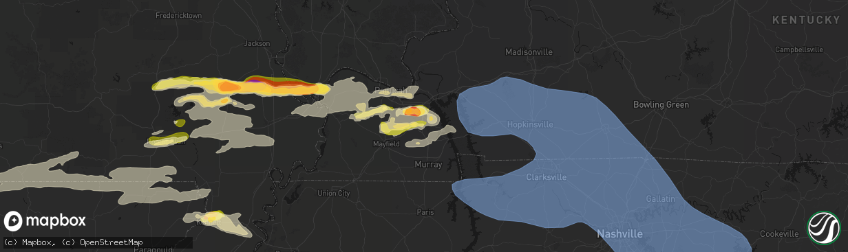
Hail Map in Benton, KY on April 16, 2026
The weather event in Benton, KY on April 16, 2026 includes Hail, Wind, and Tornado maps. 11 states and 357 cities were impacted and suffered possible damage. The total estimated number of properties impacted is 2,948.
Hail
Wind
Tornado
2,948
Estimated number of impacted properties by a 1.00" hail or larger843
Estimated number of impacted properties by a 1.75" hail or larger0
Estimated number of impacted properties by a 2.50" hail or largerStorm reports in Benton, KY
Benton, KY
| Date | Description |
|---|---|
| 04/16/20265:17 PM CDT | Trees down... Spotter estimated 60 mph wind. |
| 04/16/20265:13 PM CDT | A local report indicates 1.00 inch wind near 1 ENE Benton |
| 04/16/20265:10 PM CDT | A local report indicates 1.00 inch wind near 6 S Calvert City |
| 04/16/20265:05 PM CDT | Trees down on briensburg tatumsville road northeast of benton. |
| 04/16/20265:03 PM CDT | Late report. Some stones were egg size in palma community. |
| 04/16/20264:56 PM CDT | A local report indicates 1.00 inch wind near 5 SSW Calvert City |
| 04/16/20264:55 PM CDT | Damage to siding and broken windows in sharpe. |
| 04/16/20264:50 PM CDT | A local report indicates 1.50 inch wind near 5 SE Reidland |
All States Impacted by Hail Map on April 16, 2026
All Cities Impacted by Hail Map on April 16, 2026
- Salem, MO
- Bunker, MO
- Ellington, MO
- Bixby, MO
- Boss, MO
- Greenville, MO
- Caulfield, MO
- Bakersfield, MO
- Lesterville, MO
- Lowndes, MO
- West Plains, MO
- Koshkonong, MO
- Thayer, MO
- Gipsy, MO
- Zalma, MO
- Des Arc, MO
- Patterson, MO
- Mammoth Spring, AR
- Salem, AR
- Sturkie, AR
- Macks Creek, MO
- Couch, MO
- Iberia, MO
- Camp, AR
- Viola, AR
- Marble Hill, MO
- Ravenden, AR
- Myrtle, MO
- Advance, MO
- Warren, OH
- Cortland, OH
- Sturdivant, MO
- Crocker, MO
- Clubb, MO
- Marquand, MO
- Oran, MO
- Pocahontas, AR
- Warm Springs, AR
- Chaffee, MO
- Glenallen, MO
- Brownwood, MO
- Dixon, MO
- Ulman, MO
- Brumley, MO
- Winona, MO
- Patton, MO
- Sedgewickville, MO
- Vienna, OH
- Fowler, OH
- Gatewood, MO
- Fremont, MO
- Doniphan, MO
- Leopold, MO
- Daisy, MO
- Friedheim, MO
- Van Buren, MO
- Perryville, MO
- Benton, MO
- Scott City, MO
- Oak Ridge, MO
- Piedmont, MO
- Altenburg, MO
- Frohna, MO
- Kalamazoo, MI
- Galesburg, MI
- Portage, MI
- Brinktown, MO
- Charleston, MO
- Cairo, IL
- Miller City, IL
- Thebes, IL
- Olive Branch, IL
- Vulcan, MO
- Maynard, AR
- Success, AR
- Ellsinore, MO
- Silva, MO
- Wappapello, MO
- Naylor, MO
- Oxly, MO
- Leasburg, MO
- Cuba, MO
- Corning, AR
- Neelyville, MO
- Bloomfield, MO
- Dexter, MO
- Olean, MO
- Russellville, MO
- McGee, MO
- Vienna, MO
- Datto, AR
- Biggers, AR
- Sikeston, MO
- Bertrand, MO
- Mounds, IL
- Puxico, MO
- Essex, MO
- Barlow, KY
- La Center, KY
- Mound City, IL
- Knobel, AR
- Cunningham, KY
- Bardwell, KY
- Kevil, KY
- Pollard, AR
- Latham, MO
- Qulin, MO
- Annapolis, MO
- Wickliffe, KY
- Paducah, KY
- Melber, KY
- Eldon, MO
- Bell City, MO
- Boaz, KY
- Villa Ridge, IL
- California, MO
- Broseley, MO
- Poplar Bluff, MO
- Hickory, KY
- East Prairie, MO
- Piggott, AR
- West Paducah, KY
- Rector, AR
- Symsonia, KY
- Smithland, KY
- Mill Spring, MO
- Fredericktown, MO
- Calvert City, KY
- Centerville, MO
- Arlington, KY
- Benton, KY
- Mayfield, KY
- Campbell, MO
- Grand Rivers, KY
- Tiline, KY
- Redford, MO
- Fisk, MO
- Clinton, KY
- Brookport, IL
- Ledbetter, KY
- Eugene, MO
- Gilbertsville, KY
- Princeton, KY
- Marion, KY
- Salem, KY
- Kuttawa, KY
- Williamsville, MO
- Marathon, TX
- South Fulton, TN
- Martin, TN
- Fulton, KY
- Providence, KY
- Dawson Springs, KY
- Henley, MO
- Hardin, KY
- Dexter, KY
- Murray, KY
- Almo, KY
- Kirksey, KY
- Dudley, MO
- Fredonia, KY
- Nebo, KY
- Centertown, MO
- Lohman, MO
- Eddyville, KY
- Dresden, TN
- Palmersville, TN
- Woodgate, NY
- Forestport, NY
- Boonville, NY
- Fort Stockton, TX
- Cerulean, KY
- Snyder, TX
- Dryden, TX
- Crofton, KY
- Cadiz, KY
- Lafe, AR
- Hopkinsville, KY
- Gracey, KY
- Saint Charles, KY
- Nortonville, KY
- Pembroke, KY
- Trenton, KY
- Elkton, KY
- Cold Brook, NY
- Hoffmeister, NY
- Sanderson, TX
- Greenway, AR
- Matthews, MO
- Bernie, MO
- Oak Grove, KY
- Clarksville, TN
- Greenville, KY
- Lewisburg, KY
- Belton, KY
- Dunmor, KY
- White Plains, KY
- Guthrie, KY
- Russellville, KY
- Sharon Grove, KY
- Olmstead, KY
- Allensville, KY
- Springfield, TN
- Cedar Hill, TN
- Ashland City, TN
- Pleasant View, TN
- Adairville, KY
- Chapmansboro, TN
- Adams, TN
- Charlotte, TN
- Camden, TN
- Cumberland Furnace, TN
- Westport, TN
- Erin, TN
- Cumberland City, TN
- Holladay, TN
- McEwen, TN
- Cunningham, TN
- Hurricane Mills, TN
- White Bluff, TN
- Southside, TN
- New Johnsonville, TN
- Waverly, TN
- Dickson, TN
- Vanleer, TN
- Indian Mound, TN
- Dover, TN
- Woodlawn, TN
- Palmyra, TN
- Stewart, TN
- Buchanan, TN
- Tennessee Ridge, TN
- Big Rock, TN
- Fort Campbell, KY
- Big Sandy, TN
- Joelton, TN
- Auburn, KY
- Piseco, NY
- Lake Pleasant, NY
- Speculator, NY
- Canalou, MO
- Kennett, MO
- Holcomb, MO
- Franklin, KY
- Cross Plains, TN
- Greenbrier, TN
- Portland, TN
- Orlinda, TN
- Bragg City, MO
- White House, TN
- Goodlettsville, TN
- Parma, MO
- Gibson, MO
- Nashville, TN
- Hayti, MO
- Steele, MO
- Hermitage, TN
- Bethpage, TN
- Whites Creek, TN
- Franklin, TN
- Antioch, TN
- Smyrna, TN
- La Vergne, TN
- Mount Juliet, TN
- Madison, TN
- Castalian Springs, TN
- Hendersonville, TN
- Arrington, TN
- Nolensville, TN
- Lebanon, TN
- Old Hickory, TN
- Cottontown, TN
- Brentwood, TN
- Gallatin, TN
- Caruthersville, MO
- Warren, VT
- Granville, VT
- Bradyville, TN
- Beechgrove, TN
- Auburntown, TN
- Christiana, TN
- Milton, TN
- Gordonsville, TN
- Watertown, TN
- Alexandria, TN
- Readyville, TN
- Woodbury, TN
- Carthage, TN
- Rockvale, TN
- Brush Creek, TN
- Riddleton, TN
- Murfreesboro, TN
- Hickman, TN
- College Grove, TN
- Hartsville, TN
- Liberty, TN
- Lascassas, TN
- Bell Buckle, TN
- Eagleville, TN
- Randolph, VT
- Brookfield, VT
- Williamstown, VT
- Northfield, VT
- Roxbury, VT
- Johnstown, NY
- Gloversville, NY
- Mayfield, NY
- Waitsfield, VT
- Washington, VT
- West Topsham, VT
- Topsham, VT
- Barre, VT
- East Barre, VT
- Graniteville, VT
- Corinth, VT
- Chelsea, VT
- Mcminnville, TN
- Manchester, TN
- Buffalo Valley, TN
- Chestnut Mound, TN
- Lancaster, TN
- Smithville, TN
- Elmwood, TN
- Baxter, TN
- Morrison, TN
- Silver Point, TN
- Dowelltown, TN
- East Corinth, VT
- Newbury, VT
- Wells River, VT
- Bradford, VT
- Pike, NH
- Haverhill, NH
- North Haverhill, NH
- Oakfield, TN
- Jackson, TN
- Alton, MO
- Bath, NH
- South Ryegate, VT
- Woodsville, NH
- Groton, VT
- Milan, NH
- Cornish, NH
- Scotts, MI
- Lisbon, NH
- Caroga Lake, NY
- Broadalbin, NY
- Saint Francis, AR
- Clarkton, MO
- Woodburn, KY
- Westmoreland, TN
- Fancy Farm, KY
- North Stratford, NH
- Groveton, NH
- Northville, NY
- Warrenton, MO
- Troy, MO


