Hail Map in Wagoner, OK on May 8, 2026
The weather event in Wagoner, OK on May 8, 2026 includes Hail and Wind maps. 10 states and 438 cities were impacted and suffered possible damage. The total estimated number of properties impacted is 6,666.
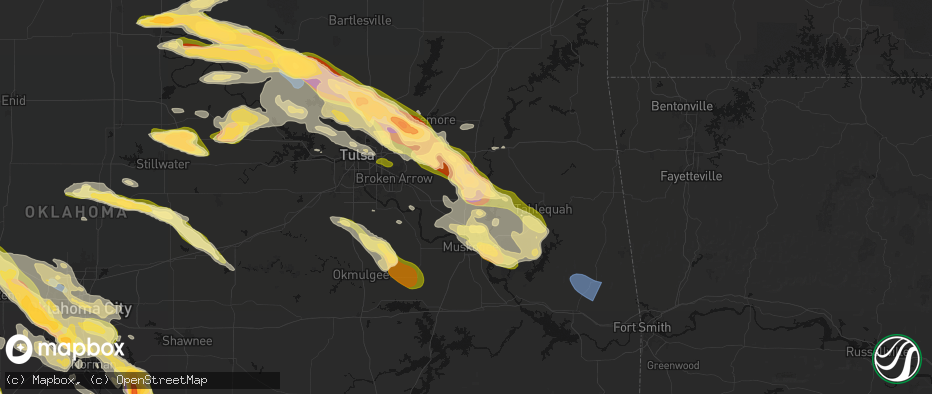
Hail
Wind
6,666
Estimated number of impacted properties by a 1.00" hail or larger6,546
Estimated number of impacted properties by a 1.75" hail or larger0
Estimated number of impacted properties by a 2.50" hail or largerStorm reports in Wagoner, OK
Wagoner, OK
| Date | Description |
|---|---|
| 05/08/20266:56 PM CDT | Reported 1 mile north of wagoner on highway 69. |
| 05/08/20266:55 PM CDT | Relayed via spotter network. Time of occurrence revised according to radar. |
All States Impacted by Hail Map on May 8, 2026
All Cities Impacted by Hail Map on May 8, 2026
- Livingston, TX
- Glenmora, LA
- Moscow, TX
- Onalaska, TX
- Forest Hill, LA
- Cheneyville, LA
- Lecompte, LA
- Trinity, TX
- Ville Platte, LA
- Bunkie, LA
- Saint Landry, LA
- Cottonport, LA
- Evergreen, LA
- Ventress, LA
- Jarreau, LA
- Saint Francisville, LA
- Jackson, LA
- Plaucheville, LA
- Simmesport, LA
- Lettsworth, LA
- Batchelor, LA
- Morrow, LA
- Slaughter, LA
- Ethel, LA
- Melville, LA
- Clinton, LA
- Greensburg, LA
- Kentwood, LA
- Amite, LA
- Wilson, LA
- Fluker, LA
- Bogalusa, LA
- Poplarville, MS
- Franklinton, LA
- Mount Hermon, LA
- Lumberton, MS
- Angie, LA
- Wiggins, MS
- Perkinston, MS
- Lucedale, MS
- Wilmer, AL
- Semmes, AL
- Eight Mile, AL
- Chunchula, AL
- Bay Minette, AL
- McDavid, FL
- Molino, FL
- Ponca City, OK
- Kaw City, OK
- Shidler, OK
- Burbank, OK
- Newkirk, OK
- Boutte, LA
- Paradis, LA
- Hahnville, LA
- Thibodaux, LA
- Des Allemands, LA
- Luling, LA
- Destrehan, LA
- Norco, LA
- Saint Rose, LA
- Ama, LA
- Jay, FL
- Cedar Vale, KS
- Milton, FL
- Fairfax, OK
- Westwego, LA
- Palatka, FL
- Marrero, LA
- Braithwaite, LA
- Harvey, LA
- Belle Chasse, LA
- Marianna, FL
- Greenwood, FL
- East Palatka, FL
- Raceland, LA
- La Place, LA
- Wynona, OK
- Pawhuska, OK
- Marathon, TX
- Sneads, FL
- Grand Ridge, FL
- Crescent, OK
- Guthrie, OK
- Mulhall, OK
- Watonga, OK
- Donalsonville, GA
- Terrell, TX
- Wills Point, TX
- Omega, OK
- Kingfisher, OK
- Barnsdall, OK
- Marland, OK
- Cairo, GA
- Okarche, OK
- Coyle, OK
- Skiatook, OK
- Crescent City, FL
- Ochlocknee, GA
- Seville, FL
- Georgetown, FL
- Perkins, OK
- El Reno, OK
- Ramona, OK
- La Cygne, KS
- Amsterdam, MO
- Calumet, OK
- Pierson, FL
- Fort Stockton, TX
- Amoret, MO
- Butler, MO
- Collinsville, OK
- Yukon, OK
- Flagler Beach, FL
- Ormond Beach, FL
- Bunnell, FL
- Ralston, OK
- Wellston, OK
- Morrison, OK
- Glencoe, OK
- Stillwater, OK
- Piedmont, OK
- Owasso, OK
- Sperry, OK
- Oklahoma City, OK
- Pawnee, OK
- Snyder, OK
- Frederick, OK
- Tryon, OK
- De Leon Springs, FL
- Elk City, KS
- Oologah, OK
- Edmond, OK
- Carney, OK
- Palm Coast, FL
- Hinton, OK
- Perry, OK
- Indiahoma, OK
- Claremore, OK
- Catoosa, OK
- Binger, OK
- Minco, OK
- Mustang, OK
- Chandler, OK
- Tulsa, OK
- Agra, OK
- Prue, OK
- Maramec, OK
- Yale, OK
- Hominy, OK
- Lookeba, OK
- Fort Scott, KS
- Fulton, KS
- Montrose, MO
- Bethany, OK
- Wheatland, OK
- Cleveland, OK
- Jennings, OK
- Anadarko, OK
- Inola, OK
- Davenport, OK
- Daytona Beach, FL
- Appleton City, MO
- Loveland, OK
- Deland, FL
- Sand Springs, OK
- Galesburg, KS
- Chattanooga, OK
- Newcastle, OK
- Norman, OK
- Pocasset, OK
- Stroud, OK
- Broken Arrow, OK
- Union City, OK
- Tuttle, OK
- Spencer, OK
- Choctaw, OK
- Port Orange, FL
- Chickasha, OK
- Osage, OK
- Osceola, MO
- Verden, OK
- Wagoner, OK
- Coweta, OK
- Chouteau, OK
- Fargo, GA
- Blanchard, OK
- New Smyrna Beach, FL
- Erie, KS
- Noble, OK
- Lexington, OK
- Walters, OK
- Walnut, KS
- Locust Grove, OK
- Pryor, OK
- Newalla, OK
- Ninnekah, OK
- Hulbert, OK
- Macomb, OK
- Wanette, OK
- Grandfield, OK
- Devol, OK
- Randlett, OK
- Farlington, KS
- Hepler, KS
- Apache, OK
- Cement, OK
- Washington, OK
- Rush Springs, OK
- Bradley, OK
- Porter, OK
- Purcell, OK
- Tecumseh, OK
- Muskogee, OK
- Fort Gibson, OK
- Tahlequah, OK
- Cyril, OK
- Mounds, OK
- Wayne, OK
- Fletcher, OK
- Elgin, OK
- Braggs, OK
- Beggs, OK
- Okmulgee, OK
- Park Hill, OK
- Bixby, OK
- Haskell, OK
- Byars, OK
- Marlow, OK
- Kirbyville, TX
- Morris, OK
- Boynton, OK
- Lawton, OK
- Fort Sill, OK
- Jasper, TX
- Council Hill, OK
- Oktaha, OK
- Roff, OK
- Bunch, OK
- Sallisaw, OK
- Ada, OK
- Stratford, OK
- Bristow, OK
- Newton, TX
- Cookson, OK
- Vian, OK
- Gore, OK
- Sapulpa, OK
- Burkeville, TX
- Kellyville, OK
- Hope, AR
- Duncan, OK
- Cache, OK
- Fitzhugh, OK
- Muldrow, OK
- Roland, OK
- Evans, LA
- Leesville, LA
- Emmet, AR
- Checotah, OK
- Callahan, FL
- Wiergate, TX
- Faxon, OK
- Comanche, OK
- Warner, OK
- Porum, OK
- Van Buren, AR
- Arkoma, OK
- Fort Smith, AR
- Prescott, AR
- Anacoco, LA
- Odell, TX
- Geronimo, OK
- Vernon, TX
- Yulee, FL
- Rosston, AR
- Chillicothe, TX
- Waurika, OK
- Webbers Falls, OK
- Stigler, OK
- Loco, OK
- Stephens, AR
- Fulton, AR
- Lavaca, AR
- Barling, AR
- Charleston, AR
- Alma, AR
- Keota, OK
- Call, TX
- Bon Wier, TX
- Rudy, AR
- Cedarville, AR
- Quanah, TX
- Ryan, OK
- Henryetta, OK
- Deport, TX
- Lake Creek, TX
- Merryville, LA
- Magazine, AR
- Booneville, AR
- Branch, AR
- Shady Point, OK
- Wolfe City, TX
- Hampton, AR
- Poteau, OK
- Ringling, OK
- Davidson, OK
- Crowell, TX
- Burkburnett, TX
- Nocona, TX
- Hartford, AR
- Bokoshe, OK
- Singer, LA
- Deridder, LA
- Harrold, TX
- Electra, TX
- Ladonia, TX
- Henrietta, TX
- Wichita Falls, TX
- Iowa Park, TX
- Saint Jo, TX
- Montague, TX
- Sulphur Springs, TX
- Como, TX
- Longville, LA
- Pickton, TX
- Moreauville, LA
- Greenville, TX
- Campbell, TX
- Monterey, LA
- Dry Creek, LA
- Yantis, TX
- Winnsboro, TX
- Scroggins, TX
- Mittie, LA
- Leesburg, TX
- Kinder, LA
- Oberlin, LA
- Portland, AR
- Holliday, TX
- Seymour, TX
- Bellevue, TX
- Pittsburg, TX
- Windthorst, TX
- Scotland, TX
- Mamou, LA
- Ore City, TX
- Quitman, TX
- Jacksboro, TX
- Bowie, TX
- Newcastle, TX
- Olney, TX
- Avinger, TX
- Lone Star, TX
- Gilmer, TX
- Jefferson, TX
- Crossett, AR
- Bastrop, LA
- Eunice, LA
- Saltillo, TX
- Diana, TX
- Perrin, TX
- Jones, LA
- Hamburg, AR
- Bonita, LA
- Karnack, TX
- Opelousas, LA
- Washington, LA
- Port Barre, LA
- Big Sandy, TX
- Oak Grove, LA
- Fordoche, LA
- Lottie, LA
- Krotz Springs, LA
- Maringouin, LA
- Livonia, LA
- Mooringsport, LA
- Benton, LA
- Belcher, LA
- Shreveport, LA
- Oil City, LA
- Longview, TX
- Vivian, LA
- Harleton, TX
- Marshall, TX
- Lake Providence, LA
- Rolling Fork, MS
- Hallsville, TX
- Bossier City, LA
- Haughton, LA
- Oscar, LA
- Minden, LA
- Grosse Tete, LA
- Mayersville, MS
- Princeton, LA
- Sibley, LA
- Doyline, LA
- Dubberly, LA
- Port Allen, LA
- Heflin, LA
- Rosedale, LA
- Waskom, TX
- Castor, LA
- Gibsland, LA
- Jamestown, LA
- Barksdale Afb, LA
- Durant, MS
- Bienville, LA
- Mansura, LA
- Goodman, MS
- Sallis, MS
- Laredo, TX
- Jonesboro, LA
- Chatham, LA
- San Ygnacio, TX
- Saline, LA
- Zapata, TX
- Columbia, LA
- Grayson, LA
- Hebbronville, TX
- Eros, LA
- Winnsboro, LA
- Ponchatoula, LA
- Wisner, LA
- Fort Necessity, LA
- Sicily Island, LA
- Gilbert, LA
- Saint Joseph, LA
- Liberty, MS
- Magnolia, MS
- Osyka, MS
- Woodville, MS
- New Roads, LA
- Greenwood, LA
- Zachary, LA
- Roseland, LA
- Denham Springs, LA
- Vera, OK


