Hail Map in Louisiana on May 8, 2026
The weather event in Louisiana on May 8, 2026 includes Hail and Wind maps. 10 states and 438 cities were impacted and suffered possible damage. The total estimated number of properties impacted is 34,502.
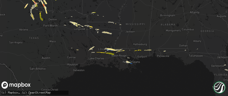
Hail
Wind
34,502
Estimated number of impacted properties by a 1.00" hail or larger0
Estimated number of impacted properties by a 1.75" hail or larger0
Estimated number of impacted properties by a 2.50" hail or largerStorm reports in Louisiana
Louisiana
| Date | Description |
|---|---|
| 05/08/20264:06 PM CDT | Several trees... Power lines... And carports damaged on multiple streets along barriere road. Video shared by media also showed strong straight line winds impacting the |
| 05/08/20263:17 PM CDT | Measured by a vessel at mm 124 on the mississippi river. |
| 05/08/20263:16 PM CDT | Public reported of half dollar sized hail in destrehan. Time estimated by radar. |
| 05/08/20263:15 PM CDT | Public report of ping pong ball sized hail. Time estimated by radar. |
| 05/08/20263:05 PM CDT | Measured from a home weather station. |
| 05/08/20268:52 AM CDT | Corrects previous hail report from 5 n slaughter. Picture of quarter sized hail in ethel. |
| 05/08/20268:50 AM CDT | Video and picture of hail estimated around ping pong ball sized. |
| 05/08/20268:48 AM CDT | Trees down in batchelor. |
| 05/08/20268:48 AM CDT | Trees down in innis. |
| 05/08/20268:30 AM CDT | Repots of downed trees at the intersection of hwy 1179 and la 107. |
| 05/08/20268:30 AM CDT | Reports of 1.5 inch hail in dupont. |
| 05/08/20268:20 AM CDT | Media reports of quarter size hail in plaucheville. |
| 05/08/20268:10 AM CDT | Reports of wind damage to a gas station on the corner of hwy 29 and hwy 71 in bunkie. |
| 05/08/20268:00 AM CDT | An nws storm survey concluded that a widespread swath of wind damage extending from bunkie to plaucheville was the result of straight line thunderstorm winds occurring |
| 05/08/20267:52 AM CDT | Picture of quarter sized hail in ethel. |
| 05/08/20266:55 AM CDT | Tree down kohnke hill rd and monteleone ln in hammond. |
| 05/08/20266:48 AM CDT | Tree down whiskey ln and johns ln in tickfaw. |
| 05/08/20266:39 AM CDT | Tree down on la 442 east of la 43. |
| 05/08/20266:23 AM CDT | Trees down on hwy 1061 between hwy 440 and hwy 1057. |
| 05/08/20264:00 AM CDT | A few pine trees snapped near the intersection of scenic drive and airport rd and in the oakmont subdivision off airport rd. Time estimated by radar. |
| 05/08/20261:30 AM CDT | Ping pong ball sized hail near litton road and parks road intersection. |
| 05/08/20261:15 AM CDT | One inch sized hail south and southeast of benton... Louisiana. |
All States Impacted by Hail Map on May 8, 2026
Cities Impacted by Hail Map on May 8, 2026
- Livingston, TX
- Glenmora, LA
- Moscow, TX
- Onalaska, TX
- Forest Hill, LA
- Cheneyville, LA
- Lecompte, LA
- Trinity, TX
- Ville Platte, LA
- Bunkie, LA
- Saint Landry, LA
- Cottonport, LA
- Evergreen, LA
- Ventress, LA
- Jarreau, LA
- Saint Francisville, LA
- Jackson, LA
- Plaucheville, LA
- Simmesport, LA
- Lettsworth, LA
- Batchelor, LA
- Morrow, LA
- Slaughter, LA
- Ethel, LA
- Melville, LA
- Clinton, LA
- Greensburg, LA
- Kentwood, LA
- Amite, LA
- Wilson, LA
- Fluker, LA
- Bogalusa, LA
- Poplarville, MS
- Franklinton, LA
- Mount Hermon, LA
- Lumberton, MS
- Angie, LA
- Wiggins, MS
- Perkinston, MS
- Lucedale, MS
- Wilmer, AL
- Semmes, AL
- Eight Mile, AL
- Chunchula, AL
- Bay Minette, AL
- McDavid, FL
- Molino, FL
- Ponca City, OK
- Kaw City, OK
- Shidler, OK
- Burbank, OK
- Newkirk, OK
- Boutte, LA
- Paradis, LA
- Hahnville, LA
- Thibodaux, LA
- Des Allemands, LA
- Luling, LA
- Destrehan, LA
- Norco, LA
- Saint Rose, LA
- Ama, LA
- Jay, FL
- Cedar Vale, KS
- Milton, FL
- Fairfax, OK
- Westwego, LA
- Palatka, FL
- Marrero, LA
- Braithwaite, LA
- Harvey, LA
- Belle Chasse, LA
- Marianna, FL
- Greenwood, FL
- East Palatka, FL
- Raceland, LA
- La Place, LA
- Wynona, OK
- Pawhuska, OK
- Marathon, TX
- Sneads, FL
- Grand Ridge, FL
- Crescent, OK
- Guthrie, OK
- Mulhall, OK
- Watonga, OK
- Donalsonville, GA
- Terrell, TX
- Wills Point, TX
- Omega, OK
- Kingfisher, OK
- Barnsdall, OK
- Marland, OK
- Cairo, GA
- Okarche, OK
- Coyle, OK
- Skiatook, OK
- Crescent City, FL
- Ochlocknee, GA
- Seville, FL
- Georgetown, FL
- Perkins, OK
- El Reno, OK
- Ramona, OK
- La Cygne, KS
- Amsterdam, MO
- Calumet, OK
- Pierson, FL
- Fort Stockton, TX
- Amoret, MO
- Butler, MO
- Collinsville, OK
- Yukon, OK
- Flagler Beach, FL
- Ormond Beach, FL
- Bunnell, FL
- Ralston, OK
- Wellston, OK
- Morrison, OK
- Glencoe, OK
- Stillwater, OK
- Piedmont, OK
- Owasso, OK
- Sperry, OK
- Oklahoma City, OK
- Pawnee, OK
- Snyder, OK
- Frederick, OK
- Tryon, OK
- De Leon Springs, FL
- Elk City, KS
- Oologah, OK
- Edmond, OK
- Carney, OK
- Palm Coast, FL
- Hinton, OK
- Perry, OK
- Indiahoma, OK
- Claremore, OK
- Catoosa, OK
- Binger, OK
- Minco, OK
- Mustang, OK
- Chandler, OK
- Tulsa, OK
- Agra, OK
- Prue, OK
- Maramec, OK
- Yale, OK
- Hominy, OK
- Lookeba, OK
- Fort Scott, KS
- Fulton, KS
- Montrose, MO
- Bethany, OK
- Wheatland, OK
- Cleveland, OK
- Jennings, OK
- Anadarko, OK
- Inola, OK
- Davenport, OK
- Daytona Beach, FL
- Appleton City, MO
- Loveland, OK
- Deland, FL
- Sand Springs, OK
- Galesburg, KS
- Chattanooga, OK
- Newcastle, OK
- Norman, OK
- Pocasset, OK
- Stroud, OK
- Broken Arrow, OK
- Union City, OK
- Tuttle, OK
- Spencer, OK
- Choctaw, OK
- Port Orange, FL
- Chickasha, OK
- Osage, OK
- Osceola, MO
- Verden, OK
- Wagoner, OK
- Coweta, OK
- Chouteau, OK
- Fargo, GA
- Blanchard, OK
- New Smyrna Beach, FL
- Erie, KS
- Noble, OK
- Lexington, OK
- Walters, OK
- Walnut, KS
- Locust Grove, OK
- Pryor, OK
- Newalla, OK
- Ninnekah, OK
- Hulbert, OK
- Macomb, OK
- Wanette, OK
- Grandfield, OK
- Devol, OK
- Randlett, OK
- Farlington, KS
- Hepler, KS
- Apache, OK
- Cement, OK
- Washington, OK
- Rush Springs, OK
- Bradley, OK
- Porter, OK
- Purcell, OK
- Tecumseh, OK
- Muskogee, OK
- Fort Gibson, OK
- Tahlequah, OK
- Cyril, OK
- Mounds, OK
- Wayne, OK
- Fletcher, OK
- Elgin, OK
- Braggs, OK
- Beggs, OK
- Okmulgee, OK
- Park Hill, OK
- Bixby, OK
- Haskell, OK
- Byars, OK
- Marlow, OK
- Kirbyville, TX
- Morris, OK
- Boynton, OK
- Lawton, OK
- Fort Sill, OK
- Jasper, TX
- Council Hill, OK
- Oktaha, OK
- Roff, OK
- Bunch, OK
- Sallisaw, OK
- Ada, OK
- Stratford, OK
- Bristow, OK
- Newton, TX
- Cookson, OK
- Vian, OK
- Gore, OK
- Sapulpa, OK
- Burkeville, TX
- Kellyville, OK
- Hope, AR
- Duncan, OK
- Cache, OK
- Fitzhugh, OK
- Muldrow, OK
- Roland, OK
- Evans, LA
- Leesville, LA
- Emmet, AR
- Checotah, OK
- Callahan, FL
- Wiergate, TX
- Faxon, OK
- Comanche, OK
- Warner, OK
- Porum, OK
- Van Buren, AR
- Arkoma, OK
- Fort Smith, AR
- Prescott, AR
- Anacoco, LA
- Odell, TX
- Geronimo, OK
- Vernon, TX
- Yulee, FL
- Rosston, AR
- Chillicothe, TX
- Waurika, OK
- Webbers Falls, OK
- Stigler, OK
- Loco, OK
- Stephens, AR
- Fulton, AR
- Lavaca, AR
- Barling, AR
- Charleston, AR
- Alma, AR
- Keota, OK
- Call, TX
- Bon Wier, TX
- Rudy, AR
- Cedarville, AR
- Quanah, TX
- Ryan, OK
- Henryetta, OK
- Deport, TX
- Lake Creek, TX
- Merryville, LA
- Magazine, AR
- Booneville, AR
- Branch, AR
- Shady Point, OK
- Wolfe City, TX
- Hampton, AR
- Poteau, OK
- Ringling, OK
- Davidson, OK
- Crowell, TX
- Burkburnett, TX
- Nocona, TX
- Hartford, AR
- Bokoshe, OK
- Singer, LA
- Deridder, LA
- Harrold, TX
- Electra, TX
- Ladonia, TX
- Henrietta, TX
- Wichita Falls, TX
- Iowa Park, TX
- Saint Jo, TX
- Montague, TX
- Sulphur Springs, TX
- Como, TX
- Longville, LA
- Pickton, TX
- Moreauville, LA
- Greenville, TX
- Campbell, TX
- Monterey, LA
- Dry Creek, LA
- Yantis, TX
- Winnsboro, TX
- Scroggins, TX
- Mittie, LA
- Leesburg, TX
- Kinder, LA
- Oberlin, LA
- Portland, AR
- Holliday, TX
- Seymour, TX
- Bellevue, TX
- Pittsburg, TX
- Windthorst, TX
- Scotland, TX
- Mamou, LA
- Ore City, TX
- Quitman, TX
- Jacksboro, TX
- Bowie, TX
- Newcastle, TX
- Olney, TX
- Avinger, TX
- Lone Star, TX
- Gilmer, TX
- Jefferson, TX
- Crossett, AR
- Bastrop, LA
- Eunice, LA
- Saltillo, TX
- Diana, TX
- Perrin, TX
- Jones, LA
- Hamburg, AR
- Bonita, LA
- Karnack, TX
- Opelousas, LA
- Washington, LA
- Port Barre, LA
- Big Sandy, TX
- Oak Grove, LA
- Fordoche, LA
- Lottie, LA
- Krotz Springs, LA
- Maringouin, LA
- Livonia, LA
- Mooringsport, LA
- Benton, LA
- Belcher, LA
- Shreveport, LA
- Oil City, LA
- Longview, TX
- Vivian, LA
- Harleton, TX
- Marshall, TX
- Lake Providence, LA
- Rolling Fork, MS
- Hallsville, TX
- Bossier City, LA
- Haughton, LA
- Oscar, LA
- Minden, LA
- Grosse Tete, LA
- Mayersville, MS
- Princeton, LA
- Sibley, LA
- Doyline, LA
- Dubberly, LA
- Port Allen, LA
- Heflin, LA
- Rosedale, LA
- Waskom, TX
- Castor, LA
- Gibsland, LA
- Jamestown, LA
- Barksdale Afb, LA
- Durant, MS
- Bienville, LA
- Mansura, LA
- Goodman, MS
- Sallis, MS
- Laredo, TX
- Jonesboro, LA
- Chatham, LA
- San Ygnacio, TX
- Saline, LA
- Zapata, TX
- Columbia, LA
- Grayson, LA
- Hebbronville, TX
- Eros, LA
- Winnsboro, LA
- Ponchatoula, LA
- Wisner, LA
- Fort Necessity, LA
- Sicily Island, LA
- Gilbert, LA
- Saint Joseph, LA
- Liberty, MS
- Magnolia, MS
- Osyka, MS
- Woodville, MS
- New Roads, LA
- Greenwood, LA
- Zachary, LA
- Roseland, LA
- Denham Springs, LA
- Vera, OK


