Hail Map in Kansas City, MO on May 31, 2026
The weather event in Kansas City, MO on May 31, 2026 includes Hail, Wind, and Tornado maps. 17 states and 717 cities were impacted and suffered possible damage. The total estimated number of properties impacted is 34,963.
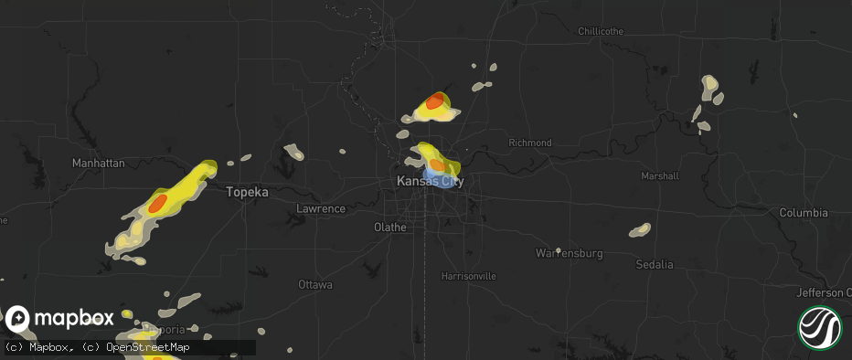
Hail
Wind
Tornado
34,963
Estimated number of impacted properties by a 1.00" hail or larger1,519
Estimated number of impacted properties by a 1.75" hail or larger0
Estimated number of impacted properties by a 2.50" hail or largerStorm reports in Kansas City, MO
Kansas City, MO
| Date | Description |
|---|---|
| 05/31/20262:59 AM CDT | Downed wires near 59th street. Time estimated from radar. |
| 05/31/20262:48 AM CDT | Downed wires near 41st and wayne. Time confirmed from radar. |
| 05/31/20262:09 AM CDT | Report from mping: quarter |
| 05/31/20261:46 AM CDT | Report from mping: quarter |
| 05/31/20261:41 AM CDT | Downed tree damaged a residence near tracy avenue. Time estimated from radar. |
| 05/31/20261:41 AM CDT | Several downed trees and limbs near 43rd street. Time estimated from radar. |
| 05/31/20261:38 AM CDT | Kmkc airport reported a peak wind gust of 82 mph at 138 am cdt. |
| 05/31/20261:38 AM CDT | Several trees down on 21st avenue. Time estimated from radar. |
| 05/31/20261:38 AM CDT | Several downed trees... Including onto vehicles... Near prather and 37th terrace. Time estimated from radar. |
| 05/31/20261:38 AM CDT | Social media report of an uprooted tree at north kansas city hospital. Time estimated from radar. |
| 05/31/20261:36 AM CDT | Downed wires near cheyenne circle. Time estimated from radar. |
| 05/31/20261:35 AM CDT | Several large branches down near swift st and 28th st. |
| 05/31/20261:35 AM CDT | Several large trees downed from storms overnight. Time estimate via radar. |
| 05/31/20261:34 AM CDT | A local report indicates 74 MPH wind near Kansas City Downtown |
| 05/31/20261:34 AM CDT | Downed tree at a residence near 38th and parvin. Time estimated from radar. |
| 05/31/20261:34 AM CDT | Tree down on a vehicle and another tree fell onto a roof... Causing damage. Time estimated from radar. |
| 05/31/20261:34 AM CDT | Several downed trees near 32nd avenue. Time estimated from radar. |
| 05/31/20261:31 AM CDT | Social media report of an uprooted tree at anita gorman park. Time estimated from radar. |
| 05/31/20261:31 AM CDT | Downed tree at a residence in gladstone. Time estimated from radar. |
| 05/31/20261:28 AM CDT | Social media report of tree damage at englewood park. Time estimated from radar. |
| 05/31/20261:25 AM CDT | Large tree downed at a residence in gladstone damaging the property. Time estimated from radar. |
| 05/31/20261:22 AM CDT | Social media report of a downed tree damaging a car at an apartment complex. Time estimated from radar. |
| 05/31/20261:18 AM CDT | Tree down on wires near edgewood circle. Time estimated from radar. |
| 05/31/20261:18 AM CDT | Downed tree at a residence near 58th street. Time estimated from radar. |
| 05/31/20261:12 AM CDT | Downed tree into a house near metro north crossing. Time estimated from radar. |
| 05/31/20261:12 AM CDT | Several trees snapped near barry and broadway. Time estimated from radar. |
| 05/31/20261:08 AM CDT | Social media report of trees down near barry and platte purchase. Time estimated from radar. |
| 05/31/202612:56 AM CDT | Social media report of multiple trees uprooted and several tree limbs down near oak and 96th. Time estimated from radar. |
| 05/31/202612:42 AM CDT | Social media report. Time estimated from radar. |
| 05/31/202612:03 AM CDT | A local report indicates 60 MPH wind near Platte Woods |
All States Impacted by Hail Map on May 31, 2026
All Cities Impacted by Hail Map on May 31, 2026
- Madison, KS
- Gridley, KS
- Burlington, KS
- Le Roy, KS
- Westphalia, KS
- Colony, KS
- Kincaid, KS
- Hughesville, MO
- La Monte, MO
- Houstonia, MO
- Bronson, KS
- Moran, KS
- Osceola, MO
- Wheatland, MO
- Weaubleau, MO
- Belle, MO
- Flemington, MO
- Climax Springs, MO
- Bland, MO
- Macks Creek, MO
- Camdenton, MO
- Dixon, MO
- Roach, MO
- Sunrise Beach, MO
- Gravois Mills, MO
- Linn Creek, MO
- Montreal, MO
- Richland, MO
- Vienna, MO
- Stoutland, MO
- Rolla, MO
- Crocker, MO
- Newburg, MO
- Brumley, MO
- Iberia, MO
- Laquey, MO
- Saint James, MO
- Brinktown, MO
- Waynesville, MO
- Saint Robert, MO
- Bourbon, MO
- Potosi, MO
- Sullivan, MO
- Devils Elbow, MO
- Jerome, MO
- Owensville, MO
- Fort Leonard Wood, MO
- Duke, MO
- Leasburg, MO
- Steelville, MO
- Cook Sta, MO
- Salem, MO
- Cherryville, MO
- Belgrade, MO
- Mineral Point, MO
- Bixby, MO
- Belleview, MO
- Rapid City, SD
- Keystone, SD
- Davisville, MO
- Black, MO
- Irondale, MO
- Hermosa, SD
- Bismarck, MO
- Park Hills, MO
- Lesterville, MO
- Caledonia, MO
- Leadwood, MO
- Bonne Terre, MO
- Ironton, MO
- Middle Brook, MO
- Pilot Knob, MO
- Doe Run, MO
- Ellington, MO
- Fort Meade, SD
- Sturgis, SD
- Nisland, SD
- Farmington, MO
- Annapolis, MO
- Vulcan, MO
- Piedmont, MO
- Albany, GA
- Leesburg, GA
- Patterson, MO
- Des Arc, MO
- Silva, MO
- Van Buren, MO
- Grandin, MO
- Greenville, MO
- Ellsinore, MO
- Williamsville, MO
- Mill Spring, MO
- Wappapello, MO
- Poplar Bluff, MO
- Roscoe, SD
- Emery, SD
- Alpine, TX
- Pecos, TX
- Monahans, TX
- Hague, ND
- Marathon, TX
- Dexter, MO
- Scott City, MO
- Fort Stockton, TX
- Alexandria, SD
- Sainte Genevieve, MO
- Arcadia, MO
- Fredericktown, MO
- Marquand, MO
- Oak Ridge, MO
- Patton, MO
- Sedgewickville, MO
- Perryville, MO
- Cape Girardeau, MO
- Daisy, MO
- Burfordville, MO
- Whitewater, MO
- Jackson, MO
- Glenallen, MO
- Marble Hill, MO
- Friedheim, MO
- Millersville, MO
- Saint Mary, MO
- Leopold, MO
- Jonesboro, IL
- McClure, IL
- Thebes, IL
- Benton, MO
- Chaffee, MO
- Tamms, IL
- Olive Branch, IL
- Cairo, IL
- Miller City, IL
- Charleston, MO
- Mounds, IL
- Pulaski, IL
- Villa Ridge, IL
- Mound City, IL
- Spencer, SD
- Barstow, TX
- Haleyville, AL
- Doniphan, MO
- Strasburg, ND
- Fairdealing, MO
- Billingsley, AL
- Prattville, AL
- Olmsted, IL
- Barlow, KY
- Ashland City, TN
- Chapmansboro, TN
- Charlotte, TN
- Canova, SD
- Marbury, AL
- Double Springs, AL
- Shellman, GA
- New Madrid, MO
- Wabbaseka, AR
- Oxly, MO
- Leola, SD
- Pyote, TX
- Birmingham, AL
- Florence, AL
- Campbell, MO
- Humphrey, AR
- Humnoke, AR
- Piggott, AR
- Naylor, MO
- Pollock, SD
- Fedora, SD
- Howard, SD
- Wink, TX
- Crosbyton, TX
- Hickman, KY
- Corning, AR
- Neelyville, MO
- Bragg City, MO
- Kennett, MO
- Dickens, TX
- Success, AR
- Union City, TN
- Clarkton, MO
- Nauvoo, AL
- Altheimer, AR
- Slaton, TX
- Tahoka, TX
- Ipswich, SD
- Knobel, AR
- Muscle Shoals, AL
- Steele, MO
- Kermit, TX
- Ralls, TX
- Linton, ND
- Hardy, AR
- Mammoth Spring, AR
- Williford, AR
- Ravenden, AR
- Carbon Hill, AL
- Ulm, AR
- Stuttgart, AR
- Bridgewater, SD
- Gobler, MO
- Sherrill, AR
- Caruthersville, MO
- Spur, TX
- Cavour, SD
- Star City, AR
- Canistota, SD
- Cooter, MO
- Hazelton, ND
- Huron, SD
- Finley, TN
- Martin, TN
- Ravenden Springs, AR
- Pocahontas, AR
- Jacksonville, AR
- North Little Rock, AR
- Post, TX
- Myrtle, MO
- Wilson, TX
- Dyersburg, TN
- De Valls Bluff, AR
- Seminole, TX
- Salem, SD
- Greenfield, TN
- Gleason, TN
- Sharon, TN
- Dresden, TN
- Blytheville, AR
- Yorktown, AR
- Jal, NM
- Andrews, TX
- Atwood, TN
- Milan, TN
- Clarksville, TN
- Trezevant, TN
- McKenzie, TN
- Kintyre, ND
- Grady, AR
- Pine Bluff, AR
- Montrose, SD
- Scott, AR
- Cumberland Furnace, TN
- Vanleer, TN
- Snyder, TX
- Justiceburg, TX
- Lonoke, AR
- Huntingdon, TN
- Humboldt, SD
- Westport, SD
- Volin, SD
- Orient, SD
- Irene, SD
- Viborg, SD
- Yuma, TN
- Kelso, TN
- Lubbock, TX
- Hobbs, NM
- Huntland, TN
- Estillfork, AL
- Paducah, TX
- Beebe, AR
- Miller, SD
- Grapevine, AR
- Flintville, TN
- Freeman, SD
- Hurley, SD
- Davis, SD
- Cresbard, SD
- Hartford, SD
- Elora, TN
- New Market, AL
- McRae, AR
- Frederick, SD
- Parker, SD
- Marion, SD
- Fayetteville, TN
- Searcy, AR
- Higginson, AR
- Garner, AR
- Loxahatchee, FL
- Chancellor, SD
- Crowell, TX
- Faulkton, SD
- Wakonda, SD
- Lennox, SD
- Olpe, KS
- Gayville, SD
- Mission Hill, SD
- Vermillion, SD
- Centerville, SD
- Beresford, SD
- Eureka, SD
- Old Glory, TX
- Aspermont, TX
- Memphis, TX
- Lorenzo, TX
- Hosmer, SD
- Emporia, KS
- Tea, SD
- Wellington, TX
- Childress, TX
- Tucker, AR
- England, AR
- Wolfforth, TX
- Shallowater, TX
- Quail, TX
- Ropesville, TX
- Aberdeen, SD
- Waterloo, NE
- Long Lake, SD
- Alcester, SD
- Hudson, SD
- Levelland, TX
- Burbank, SD
- Omaha, NE
- Elkhorn, NE
- Admire, KS
- Reading, KS
- Elk Point, SD
- Smyer, TX
- Hartford, KS
- Newcastle, NE
- Fairview, OK
- Longdale, OK
- Conway Springs, KS
- Argonia, KS
- Waverly, KS
- Gypsum, KS
- Seiling, OK
- Groton, SD
- Jacksonville, FL
- Bath, SD
- Lebo, KS
- Neosho Rapids, KS
- Tampa, KS
- Durham, KS
- Akron, IA
- Westfield, IA
- Ponca, NE
- Chester, OK
- Hope, KS
- Modale, IA
- Garnett, KS
- Wisner, NE
- Marion, KS
- Jefferson, SD
- Sioux City, IA
- Hillsboro, KS
- Mondamin, IA
- Merrill, IA
- Abilene, KS
- Hinton, IA
- Tekamah, NE
- Little Sioux, IA
- Pisgah, IA
- Dodge, NE
- Ashton, IA
- Logan, IA
- Persia, IA
- Portsmouth, IA
- Onawa, IA
- Taloga, OK
- Woodbine, IA
- Scribner, NE
- Lawton, IA
- Shelby, IA
- McLouth, KS
- Leavenworth, KS
- Kansas City, MO
- Platte City, MO
- Council Grove, KS
- Cottonwood Falls, KS
- Harlan, IA
- Strong City, KS
- Missouri Valley, IA
- Lyons, NE
- Bancroft, NE
- Neosho Falls, KS
- Smithville, MO
- Hooper, NE
- Welda, KS
- Iola, KS
- Hornick, IA
- Bronson, IA
- Moville, IA
- Salix, IA
- Alta Vista, KS
- Eureka, KS
- Piedmont, KS
- Walthill, NE
- Sloan, IA
- Decatur, NE
- Dwight, KS
- Alma, KS
- Arlington, NE
- Herman, NE
- Craig, NE
- Valley Falls, KS
- Silver Lake, KS
- Severy, KS
- Yates Center, KS
- Toronto, KS
- Macy, NE
- Avoca, IA
- La Harpe, KS
- Dalton, MO
- Kearney, MO
- Edgerton, MO
- Oakland, NE
- Howard, KS
- Trimble, MO
- Plattsburg, MO
- Allen, KS
- Oskaloosa, KS
- Keytesville, MO
- Rosalie, NE
- Neola, IA
- Eskridge, KS
- Virgil, KS
- Fredonia, KS
- Neal, KS
- Piqua, KS
- Blue Mound, KS
- Holt, MO
- Ozawkie, KS
- Blair, NE
- Riverside, MO
- Topeka, KS
- Fall River, KS
- Mutual, OK
- Salisbury, MO
- Paxico, KS
- Maple Hill, KS
- Buffalo, KS
- Kennard, NE
- Walnut, IA
- Uniontown, KS
- Hoyt, KS
- Kansas City, KS
- Lathrop, MO
- Liberty, MO
- Minden, IA
- Moberly, MO
- Elk City, KS
- Fort Calhoun, NE
- Humboldt, KS
- Hamilton, KS
- Mapleton, KS
- Benedict, KS
- Rossville, KS
- Independence, MO
- Hancock, IA
- Oakland, IA
- Glasgow, MO
- Marceline, MO
- Bennington, NE
- Altoona, KS
- Chanute, KS
- Erie, KS
- Warrensburg, MO
- Centerview, MO
- Turney, MO
- Cameron, MO
- Polo, MO
- Carson, IA
- Griswold, IA
- Neodesha, KS
- Thayer, KS
- Slater, MO
- Bloomsdale, MO
- Gilliam, MO
- Independence, KS
- Kingston, MO
- Stark, KS
- Underwood, IA
- McFarland, KS
- Saint Marys, KS
- Hardin, MO
- Norborne, MO
- Blue Springs, MO
- Fayette, MO
- Armstrong, MO
- Galesburg, KS
- Cherryvale, KS
- Napoleon, MO
- Newcastle, TX
- Council Bluffs, IA
- Bogard, MO
- Carrollton, MO
- Madison, MO
- Boys Town, NE
- Redfield, KS
- Shawnee, KS
- Henderson, IA
- Lees Summit, MO
- Franklin, MO
- Hamilton, MO
- Wellington, MO
- Sedan, KS
- Sibley, MO
- Treynor, IA
- Paris, MO
- Centralia, MO
- Peru, KS
- Red Oak, IA
- Clarence, MO
- Excello, MO
- Jacksonville, MO
- McClelland, IA
- Savonburg, KS
- Lexington, MO
- Silver City, IA
- Emerson, IA
- Elliott, IA
- New Franklin, MO
- Breckenridge, MO
- Bates City, MO
- Weston, MO
- Dearborn, MO
- Grain Valley, MO
- Oak Grove, MO
- Caney, KS
- Niotaze, KS
- Buckner, MO
- Havana, KS
- Santa Fe, MO
- Mexico, MO
- Richards, MO
- Rocheport, MO
- Chillicothe, MO
- Sturgeon, MO
- Dennis, KS
- Liberal, MO
- Nevada, MO
- Parsons, KS
- Harrisburg, MO
- Sheldon, MO
- Milo, MO
- Higginsville, MO
- Concordia, MO
- Alma, MO
- Corder, MO
- Blackburn, MO
- Clark, MO
- Stoutsville, MO
- Prairie Du Rocher, IL
- Old Monroe, MO
- Perry, MO
- California, MO
- Mendon, MO
- Elsberry, MO
- Winfield, MO
- Foley, MO
- Centertown, MO
- Jamestown, MO
- Saint Louis, MO
- Brunswick, MO
- Columbia, MO
- Russellville, MO
- Hallsville, MO
- Batchtown, IL
- Tina, MO
- Hale, MO
- Sumner, MO
- Triplett, MO
- Rothville, MO
- New Cambria, MO
- Bucklin, MO
- Brussels, IL
- Fieldon, IL
- Jefferson City, MO
- Hartsburg, MO
- Belleville, IL
- East Saint Louis, IL
- Ashland, MO
- Saint Charles, MO
- Lohman, MO
- Saint Thomas, MO
- Henley, MO
- Grafton, IL
- Vandalia, MO
- Monroe City, MO
- Fulton, MO
- Clarksville, MO
- Eolia, MO
- Hardin, IL
- New Bloomfield, MO
- Auxvasse, MO
- Kingdom City, MO
- Trenton, MO
- Freeburg, MO
- South Roxana, IL
- Hartford, IL
- Westphalia, MO
- Modoc, IL
- Evansville, IL
- Holts Summit, MO
- Troy, IL
- Maryville, IL
- Collinsville, IL
- Curryville, MO
- Williamsburg, MO
- Steedman, MO
- Mokane, MO
- Montgomery City, MO
- Martinsburg, MO
- Jamesport, MO
- Lock Springs, MO
- Scott Air Force Base, IL
- Argyle, MO
- Lebanon, IL
- Koeltztown, MO
- Mooresville, MO
- Roxana, IL
- Edwardsville, IL
- Glen Carbon, IL
- Meta, MO
- Tebbetts, MO
- Freeburg, IL
- New London, MO
- Morrison, MO
- Chamois, MO
- Rhineland, MO
- Portland, MO
- New Florence, MO
- Shambaugh, IA
- Clarinda, IA
- Braddyville, IA
- O'Fallon, MO
- Ellis Grove, IL
- Marine, IL
- New Athens, IL
- Bonnots Mill, MO
- Portage Des Sioux, MO
- Linn, MO
- Granite City, IL
- Red Bud, IL
- Mascoutah, IL
- New Baden, IL
- Loose Creek, MO
- Jonesburg, MO
- High Hill, MO
- Hermann, MO
- Warrenton, MO
- Rockport, IL
- Clearmont, MO
- Golden Eagle, IL
- Albers, IL
- O'Fallon, IL
- East Alton, IL
- Cuba, MO
- Kevil, KY
- Pittsfield, IL
- Pleasant Hill, IL
- Germantown, IL
- Bartelso, IL
- West Paducah, KY
- Metropolis, IL
- Caseyville, IL
- Berger, MO
- Wright City, MO
- Marthasville, MO
- Nebo, IL
- Pearl, IL
- Fairview Heights, IL
- Brookport, IL
- Ballwin, MO
- Madison, IL
- Paducah, KY
- Smithland, KY
- Chesterfield, MO
- Smithton, IL
- East Carondelet, IL
- Symsonia, KY
- Calvert City, KY
- Maryland Heights, MO
- Benton, KY
- Belknap, IL
- Grantsburg, IL
- Bridgeton, MO
- Earth City, MO
- Lenzburg, IL
- Cutler, IL
- Columbia, IL
- Millstadt, IL
- Simpson, IL
- Gilbertsville, KY
- Dupo, IL
- Golconda, IL
- Richwoods, MO
- Blackwell, MO
- Baldwin, IL
- Bethune, CO
- Dexter, KY
- Hardin, KY
- Cadet, MO
- Eminence, MO
- Pinckneyville, IL
- Du Quoin, IL
- Chester, IL
- Eddyville, IL
- Sparta, IL
- Burlington, CO
- Johnston City, IL
- Steeleville, IL
- Percy, IL
- Ledbetter, KY
- Winona, MO
- Marion, IL
- Marissa, IL
- Murray, KY
- Walsh, IL
- Coulterville, IL
- Mayview, MO
- Odessa, MO
- Lansing, KS
- Mission, KS


