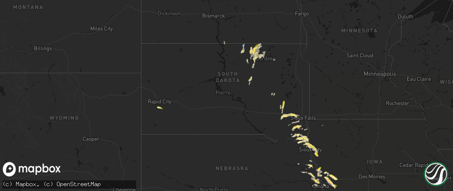
Hail Map in South Dakota on May 31, 2026
The weather event in South Dakota on May 31, 2026 includes Hail, Wind, and Tornado maps. 17 states and 717 cities were impacted and suffered possible damage. The total estimated number of properties impacted is 5,185.
Hail
Wind
Tornado
5,185
Estimated number of impacted properties by a 1.00" hail or larger418
Estimated number of impacted properties by a 1.75" hail or larger0
Estimated number of impacted properties by a 2.50" hail or largerStorm reports in South Dakota
South Dakota
| Date | Description |
|---|---|
| 05/31/20266:58 PM CDT | Ping pong ball sized hail damaged young crops in fields. |
| 05/31/20266:51 PM CDT | Most hail was pea to quarter sized... But a few were as big as golf balls. Farm fields further north are more damaged than his. |
| 05/31/20266:45 PM CDT | No noticeable damage from the strong winds. |
| 05/31/20266:20 PM CDT | A local report indicates 1.00 inch wind near 3 SSW Leola |
| 05/31/20266:20 PM CDT | A local report indicates 1.00 inch wind near Leola |
| 05/31/20266:16 PM CDT | Hail was jagged... With some as long as a quarter... But most of it was pea to nickel sized. Heavy rainfall so far has been 1.75 inch. |
| 05/31/20266:07 PM CDT | Tornado is kicking up dust from the ground now. |
| 05/31/20265:30 PM CDT | Very heavy rain along with penny to quarter sized hail. Rainfall is already over 3 inches. |
| 05/31/20265:07 PM CDT | A local report indicates 1.25 inch wind near 2 W Vilas |
| 05/31/20264:28 PM CDT | Mostly dime size hail with the largest stones quarter size. Time estimated by radar. |
| 05/31/20264:25 PM CDT | Mostly nickel to quarter size. |
| 05/30/202610:05 PM CDT | Most hail was pea to nickel sized... But a few were quarter sized. Looked like a wall cloud was about 3 to 4 miles to the west. |
| 05/30/20269:28 PM CDT | Corrects time in previous hail report from 6 nnw vermillion. Report and photo via social media. |
| 05/30/20269:15 PM CDT | Mesonet station llks2 eureka 13 ene. |
| 05/30/20268:54 PM CDT | Tornado observed from chaser live feed. |
| 05/30/20268:45 PM CDT | A local report indicates 1.00 inch wind near Davis |
| 05/30/20268:36 PM CDT | Report via social media. |
| 05/30/20268:28 PM CDT | Report and photo via social media. |
| 05/30/20268:11 PM CDT | Radar confirmed tonado. |
| 05/30/20267:56 PM CDT | Report and photo via social media. |
| 05/30/20267:54 PM CDT | A local report indicates 1.00 inch wind near 2 WNW Davis |
| 05/30/20267:40 PM CDT | Report and photo via social media. |
| 05/30/20267:39 PM CDT | Report and video via social media. |
| 05/30/20267:33 PM CDT | A local report indicates 1.00 inch wind near 4 SW Hurley |
| 05/30/20267:26 PM CDT | In addition to hail up to the size of quarters... Heavy rainfall was reported. |
| 05/30/20267:20 PM CDT | Photo and report via social media. |
All States Impacted by Hail Map on May 31, 2026
Cities Impacted by Hail Map on May 31, 2026
- Madison, KS
- Gridley, KS
- Burlington, KS
- Le Roy, KS
- Westphalia, KS
- Colony, KS
- Kincaid, KS
- Hughesville, MO
- La Monte, MO
- Houstonia, MO
- Bronson, KS
- Moran, KS
- Osceola, MO
- Wheatland, MO
- Weaubleau, MO
- Belle, MO
- Flemington, MO
- Climax Springs, MO
- Bland, MO
- Macks Creek, MO
- Camdenton, MO
- Dixon, MO
- Roach, MO
- Sunrise Beach, MO
- Gravois Mills, MO
- Linn Creek, MO
- Montreal, MO
- Richland, MO
- Vienna, MO
- Stoutland, MO
- Rolla, MO
- Crocker, MO
- Newburg, MO
- Brumley, MO
- Iberia, MO
- Laquey, MO
- Saint James, MO
- Brinktown, MO
- Waynesville, MO
- Saint Robert, MO
- Bourbon, MO
- Potosi, MO
- Sullivan, MO
- Devils Elbow, MO
- Jerome, MO
- Owensville, MO
- Fort Leonard Wood, MO
- Duke, MO
- Leasburg, MO
- Steelville, MO
- Cook Sta, MO
- Salem, MO
- Cherryville, MO
- Belgrade, MO
- Mineral Point, MO
- Bixby, MO
- Belleview, MO
- Rapid City, SD
- Keystone, SD
- Davisville, MO
- Black, MO
- Irondale, MO
- Hermosa, SD
- Bismarck, MO
- Park Hills, MO
- Lesterville, MO
- Caledonia, MO
- Leadwood, MO
- Bonne Terre, MO
- Ironton, MO
- Middle Brook, MO
- Pilot Knob, MO
- Doe Run, MO
- Ellington, MO
- Fort Meade, SD
- Sturgis, SD
- Nisland, SD
- Farmington, MO
- Annapolis, MO
- Vulcan, MO
- Piedmont, MO
- Albany, GA
- Leesburg, GA
- Patterson, MO
- Des Arc, MO
- Silva, MO
- Van Buren, MO
- Grandin, MO
- Greenville, MO
- Ellsinore, MO
- Williamsville, MO
- Mill Spring, MO
- Wappapello, MO
- Poplar Bluff, MO
- Roscoe, SD
- Emery, SD
- Alpine, TX
- Pecos, TX
- Monahans, TX
- Hague, ND
- Marathon, TX
- Dexter, MO
- Scott City, MO
- Fort Stockton, TX
- Alexandria, SD
- Sainte Genevieve, MO
- Arcadia, MO
- Fredericktown, MO
- Marquand, MO
- Oak Ridge, MO
- Patton, MO
- Sedgewickville, MO
- Perryville, MO
- Cape Girardeau, MO
- Daisy, MO
- Burfordville, MO
- Whitewater, MO
- Jackson, MO
- Glenallen, MO
- Marble Hill, MO
- Friedheim, MO
- Millersville, MO
- Saint Mary, MO
- Leopold, MO
- Jonesboro, IL
- McClure, IL
- Thebes, IL
- Benton, MO
- Chaffee, MO
- Tamms, IL
- Olive Branch, IL
- Cairo, IL
- Miller City, IL
- Charleston, MO
- Mounds, IL
- Pulaski, IL
- Villa Ridge, IL
- Mound City, IL
- Spencer, SD
- Barstow, TX
- Haleyville, AL
- Doniphan, MO
- Strasburg, ND
- Fairdealing, MO
- Billingsley, AL
- Prattville, AL
- Olmsted, IL
- Barlow, KY
- Ashland City, TN
- Chapmansboro, TN
- Charlotte, TN
- Canova, SD
- Marbury, AL
- Double Springs, AL
- Shellman, GA
- New Madrid, MO
- Wabbaseka, AR
- Oxly, MO
- Leola, SD
- Pyote, TX
- Birmingham, AL
- Florence, AL
- Campbell, MO
- Humphrey, AR
- Humnoke, AR
- Piggott, AR
- Naylor, MO
- Pollock, SD
- Fedora, SD
- Howard, SD
- Wink, TX
- Crosbyton, TX
- Hickman, KY
- Corning, AR
- Neelyville, MO
- Bragg City, MO
- Kennett, MO
- Dickens, TX
- Success, AR
- Union City, TN
- Clarkton, MO
- Nauvoo, AL
- Altheimer, AR
- Slaton, TX
- Tahoka, TX
- Ipswich, SD
- Knobel, AR
- Muscle Shoals, AL
- Steele, MO
- Kermit, TX
- Ralls, TX
- Linton, ND
- Hardy, AR
- Mammoth Spring, AR
- Williford, AR
- Ravenden, AR
- Carbon Hill, AL
- Ulm, AR
- Stuttgart, AR
- Bridgewater, SD
- Gobler, MO
- Sherrill, AR
- Caruthersville, MO
- Spur, TX
- Cavour, SD
- Star City, AR
- Canistota, SD
- Cooter, MO
- Hazelton, ND
- Huron, SD
- Finley, TN
- Martin, TN
- Ravenden Springs, AR
- Pocahontas, AR
- Jacksonville, AR
- North Little Rock, AR
- Post, TX
- Myrtle, MO
- Wilson, TX
- Dyersburg, TN
- De Valls Bluff, AR
- Seminole, TX
- Salem, SD
- Greenfield, TN
- Gleason, TN
- Sharon, TN
- Dresden, TN
- Blytheville, AR
- Yorktown, AR
- Jal, NM
- Andrews, TX
- Atwood, TN
- Milan, TN
- Clarksville, TN
- Trezevant, TN
- McKenzie, TN
- Kintyre, ND
- Grady, AR
- Pine Bluff, AR
- Montrose, SD
- Scott, AR
- Cumberland Furnace, TN
- Vanleer, TN
- Snyder, TX
- Justiceburg, TX
- Lonoke, AR
- Huntingdon, TN
- Humboldt, SD
- Westport, SD
- Volin, SD
- Orient, SD
- Irene, SD
- Viborg, SD
- Yuma, TN
- Kelso, TN
- Lubbock, TX
- Hobbs, NM
- Huntland, TN
- Estillfork, AL
- Paducah, TX
- Beebe, AR
- Miller, SD
- Grapevine, AR
- Flintville, TN
- Freeman, SD
- Hurley, SD
- Davis, SD
- Cresbard, SD
- Hartford, SD
- Elora, TN
- New Market, AL
- McRae, AR
- Frederick, SD
- Parker, SD
- Marion, SD
- Fayetteville, TN
- Searcy, AR
- Higginson, AR
- Garner, AR
- Loxahatchee, FL
- Chancellor, SD
- Crowell, TX
- Faulkton, SD
- Wakonda, SD
- Lennox, SD
- Olpe, KS
- Gayville, SD
- Mission Hill, SD
- Vermillion, SD
- Centerville, SD
- Beresford, SD
- Eureka, SD
- Old Glory, TX
- Aspermont, TX
- Memphis, TX
- Lorenzo, TX
- Hosmer, SD
- Emporia, KS
- Tea, SD
- Wellington, TX
- Childress, TX
- Tucker, AR
- England, AR
- Wolfforth, TX
- Shallowater, TX
- Quail, TX
- Ropesville, TX
- Aberdeen, SD
- Waterloo, NE
- Long Lake, SD
- Alcester, SD
- Hudson, SD
- Levelland, TX
- Burbank, SD
- Omaha, NE
- Elkhorn, NE
- Admire, KS
- Reading, KS
- Elk Point, SD
- Smyer, TX
- Hartford, KS
- Newcastle, NE
- Fairview, OK
- Longdale, OK
- Conway Springs, KS
- Argonia, KS
- Waverly, KS
- Gypsum, KS
- Seiling, OK
- Groton, SD
- Jacksonville, FL
- Bath, SD
- Lebo, KS
- Neosho Rapids, KS
- Tampa, KS
- Durham, KS
- Akron, IA
- Westfield, IA
- Ponca, NE
- Chester, OK
- Hope, KS
- Modale, IA
- Garnett, KS
- Wisner, NE
- Marion, KS
- Jefferson, SD
- Sioux City, IA
- Hillsboro, KS
- Mondamin, IA
- Merrill, IA
- Abilene, KS
- Hinton, IA
- Tekamah, NE
- Little Sioux, IA
- Pisgah, IA
- Dodge, NE
- Ashton, IA
- Logan, IA
- Persia, IA
- Portsmouth, IA
- Onawa, IA
- Taloga, OK
- Woodbine, IA
- Scribner, NE
- Lawton, IA
- Shelby, IA
- McLouth, KS
- Leavenworth, KS
- Kansas City, MO
- Platte City, MO
- Council Grove, KS
- Cottonwood Falls, KS
- Harlan, IA
- Strong City, KS
- Missouri Valley, IA
- Lyons, NE
- Bancroft, NE
- Neosho Falls, KS
- Smithville, MO
- Hooper, NE
- Welda, KS
- Iola, KS
- Hornick, IA
- Bronson, IA
- Moville, IA
- Salix, IA
- Alta Vista, KS
- Eureka, KS
- Piedmont, KS
- Walthill, NE
- Sloan, IA
- Decatur, NE
- Dwight, KS
- Alma, KS
- Arlington, NE
- Herman, NE
- Craig, NE
- Valley Falls, KS
- Silver Lake, KS
- Severy, KS
- Yates Center, KS
- Toronto, KS
- Macy, NE
- Avoca, IA
- La Harpe, KS
- Dalton, MO
- Kearney, MO
- Edgerton, MO
- Oakland, NE
- Howard, KS
- Trimble, MO
- Plattsburg, MO
- Allen, KS
- Oskaloosa, KS
- Keytesville, MO
- Rosalie, NE
- Neola, IA
- Eskridge, KS
- Virgil, KS
- Fredonia, KS
- Neal, KS
- Piqua, KS
- Blue Mound, KS
- Holt, MO
- Ozawkie, KS
- Blair, NE
- Riverside, MO
- Topeka, KS
- Fall River, KS
- Mutual, OK
- Salisbury, MO
- Paxico, KS
- Maple Hill, KS
- Buffalo, KS
- Kennard, NE
- Walnut, IA
- Uniontown, KS
- Hoyt, KS
- Kansas City, KS
- Lathrop, MO
- Liberty, MO
- Minden, IA
- Moberly, MO
- Elk City, KS
- Fort Calhoun, NE
- Humboldt, KS
- Hamilton, KS
- Mapleton, KS
- Benedict, KS
- Rossville, KS
- Independence, MO
- Hancock, IA
- Oakland, IA
- Glasgow, MO
- Marceline, MO
- Bennington, NE
- Altoona, KS
- Chanute, KS
- Erie, KS
- Warrensburg, MO
- Centerview, MO
- Turney, MO
- Cameron, MO
- Polo, MO
- Carson, IA
- Griswold, IA
- Neodesha, KS
- Thayer, KS
- Slater, MO
- Bloomsdale, MO
- Gilliam, MO
- Independence, KS
- Kingston, MO
- Stark, KS
- Underwood, IA
- McFarland, KS
- Saint Marys, KS
- Hardin, MO
- Norborne, MO
- Blue Springs, MO
- Fayette, MO
- Armstrong, MO
- Galesburg, KS
- Cherryvale, KS
- Napoleon, MO
- Newcastle, TX
- Council Bluffs, IA
- Bogard, MO
- Carrollton, MO
- Madison, MO
- Boys Town, NE
- Redfield, KS
- Shawnee, KS
- Henderson, IA
- Lees Summit, MO
- Franklin, MO
- Hamilton, MO
- Wellington, MO
- Sedan, KS
- Sibley, MO
- Treynor, IA
- Paris, MO
- Centralia, MO
- Peru, KS
- Red Oak, IA
- Clarence, MO
- Excello, MO
- Jacksonville, MO
- McClelland, IA
- Savonburg, KS
- Lexington, MO
- Silver City, IA
- Emerson, IA
- Elliott, IA
- New Franklin, MO
- Breckenridge, MO
- Bates City, MO
- Weston, MO
- Dearborn, MO
- Grain Valley, MO
- Oak Grove, MO
- Caney, KS
- Niotaze, KS
- Buckner, MO
- Havana, KS
- Santa Fe, MO
- Mexico, MO
- Richards, MO
- Rocheport, MO
- Chillicothe, MO
- Sturgeon, MO
- Dennis, KS
- Liberal, MO
- Nevada, MO
- Parsons, KS
- Harrisburg, MO
- Sheldon, MO
- Milo, MO
- Higginsville, MO
- Concordia, MO
- Alma, MO
- Corder, MO
- Blackburn, MO
- Clark, MO
- Stoutsville, MO
- Prairie Du Rocher, IL
- Old Monroe, MO
- Perry, MO
- California, MO
- Mendon, MO
- Elsberry, MO
- Winfield, MO
- Foley, MO
- Centertown, MO
- Jamestown, MO
- Saint Louis, MO
- Brunswick, MO
- Columbia, MO
- Russellville, MO
- Hallsville, MO
- Batchtown, IL
- Tina, MO
- Hale, MO
- Sumner, MO
- Triplett, MO
- Rothville, MO
- New Cambria, MO
- Bucklin, MO
- Brussels, IL
- Fieldon, IL
- Jefferson City, MO
- Hartsburg, MO
- Belleville, IL
- East Saint Louis, IL
- Ashland, MO
- Saint Charles, MO
- Lohman, MO
- Saint Thomas, MO
- Henley, MO
- Grafton, IL
- Vandalia, MO
- Monroe City, MO
- Fulton, MO
- Clarksville, MO
- Eolia, MO
- Hardin, IL
- New Bloomfield, MO
- Auxvasse, MO
- Kingdom City, MO
- Trenton, MO
- Freeburg, MO
- South Roxana, IL
- Hartford, IL
- Westphalia, MO
- Modoc, IL
- Evansville, IL
- Holts Summit, MO
- Troy, IL
- Maryville, IL
- Collinsville, IL
- Curryville, MO
- Williamsburg, MO
- Steedman, MO
- Mokane, MO
- Montgomery City, MO
- Martinsburg, MO
- Jamesport, MO
- Lock Springs, MO
- Scott Air Force Base, IL
- Argyle, MO
- Lebanon, IL
- Koeltztown, MO
- Mooresville, MO
- Roxana, IL
- Edwardsville, IL
- Glen Carbon, IL
- Meta, MO
- Tebbetts, MO
- Freeburg, IL
- New London, MO
- Morrison, MO
- Chamois, MO
- Rhineland, MO
- Portland, MO
- New Florence, MO
- Shambaugh, IA
- Clarinda, IA
- Braddyville, IA
- O'Fallon, MO
- Ellis Grove, IL
- Marine, IL
- New Athens, IL
- Bonnots Mill, MO
- Portage Des Sioux, MO
- Linn, MO
- Granite City, IL
- Red Bud, IL
- Mascoutah, IL
- New Baden, IL
- Loose Creek, MO
- Jonesburg, MO
- High Hill, MO
- Hermann, MO
- Warrenton, MO
- Rockport, IL
- Clearmont, MO
- Golden Eagle, IL
- Albers, IL
- O'Fallon, IL
- East Alton, IL
- Cuba, MO
- Kevil, KY
- Pittsfield, IL
- Pleasant Hill, IL
- Germantown, IL
- Bartelso, IL
- West Paducah, KY
- Metropolis, IL
- Caseyville, IL
- Berger, MO
- Wright City, MO
- Marthasville, MO
- Nebo, IL
- Pearl, IL
- Fairview Heights, IL
- Brookport, IL
- Ballwin, MO
- Madison, IL
- Paducah, KY
- Smithland, KY
- Chesterfield, MO
- Smithton, IL
- East Carondelet, IL
- Symsonia, KY
- Calvert City, KY
- Maryland Heights, MO
- Benton, KY
- Belknap, IL
- Grantsburg, IL
- Bridgeton, MO
- Earth City, MO
- Lenzburg, IL
- Cutler, IL
- Columbia, IL
- Millstadt, IL
- Simpson, IL
- Gilbertsville, KY
- Dupo, IL
- Golconda, IL
- Richwoods, MO
- Blackwell, MO
- Baldwin, IL
- Bethune, CO
- Dexter, KY
- Hardin, KY
- Cadet, MO
- Eminence, MO
- Pinckneyville, IL
- Du Quoin, IL
- Chester, IL
- Eddyville, IL
- Sparta, IL
- Burlington, CO
- Johnston City, IL
- Steeleville, IL
- Percy, IL
- Ledbetter, KY
- Winona, MO
- Marion, IL
- Marissa, IL
- Murray, KY
- Walsh, IL
- Coulterville, IL
- Mayview, MO
- Odessa, MO
- Lansing, KS
- Mission, KS


